 Block
From the record
One of 162 National Register listings published here for Benton County · listed in 1988 · category: Building.
Sources: the National Register database, National Park Service · the Wikipedia article
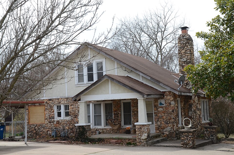
Listed on the National Register of Historic Places in 1988.
One of 162 National Register listings published here for Benton County · listed in 1988 · category: Building.
Sources: the National Register database, National Park Service · the Wikipedia article
Regional context, not property-specific evidence. The federal wildfire occurrence database lists 13 fires within 5 miles of Bertschy House between 1998 and 2019, burning about 272 acres in total. None started naturally. 4 were recorded as arson. Distance is straight-line from the map coordinates, so a fire counted here may appear on a neighbouring settlement's page as well.
| Reported cause | Fires |
|---|---|
| Missing data/not specified/undetermined | 5 |
| Arson/incendiarism | 4 |
| Smoking | 2 |
| Debris and open burning | 1 |
| Equipment and vehicle use | 1 |
The most recent of them, most recent first, with the day each was reported and the service that recorded it.
| Date | Cause | Size | Reported by | Name on the report |
|---|---|---|---|---|
| 26 August 2011 | Equipment and vehicle use | 8.0 acres | Arkansas Forestry Commission | not named |
| 25 July 2012 | Smoking | 23 acres | Arkansas Forestry Commission | not named |
| 17 July 2012 | Missing data/not specified/undetermined | 5.0 acres | Arkansas Forestry Commission | not named |
| 9 April 2019 | Missing data/not specified/undetermined | 3.0 acres | Arkansas Forestry Commission | not named |
| 8 April 1998 | Smoking | 2.0 acres | Arkansas Forestry Commission | not named |
| 5 March 2007 | Arson/incendiarism | 80 acres | Arkansas Forestry Commission | not named |
| 29 February 2016 | Debris and open burning | 25 acres | Arkansas Forestry Commission | not named |
| 1 February 2017 | Missing data/not specified/undetermined | 5.0 acres | Arkansas Forestry Commission | not named |
Regional context, not property-specific evidence. The federal mineral resources record lists 5 workings within 5 miles of Bertschy House: 5 unknowns. None of them still produces. What was taken out: Sand and Gravel, Construction, Stone. Distance is straight-line from the map coordinates, so a quarry counted here may appear on a neighbouring settlement's page as well.
Regional context, not property-specific evidence. The National Weather Service names Bentonville, the town this property stands in, in 106 storm reports between 1993 and 2025: 44 hail, 41 thunderstorm wind, 11 flash flood, 5 lightning. The reports record 5 injuries. Each account below is quoted exactly as the forecast office filed it, from the NOAA Storm Events Database, and each date opens the federal record of that event.
| When | Event | Place named | Harm | What the report says |
|---|---|---|---|---|
| August 2006 | Thunderstorm Wind | Bentonville | 2 hurt, $50,000 | Thunderstorm winds estimated at 70 miles an hour damaged roofs, blew down trees, and damaged power lines. A home under construction was destroyed. A truck driver was injured when his truck was blown off a road. Another injury occurred when a portion of a brick wall was blown down onto a brick layer who was working on it. |
| August 2009 | Lightning | Bentonville | 1 hurt, $2,000 | Lightning struck a vehicle, injuring a storm chaser who was filming the storms as they moved through northwest Arkansas. |
| May 2004 | Lightning | Bentonville | 1 hurt | A man was struck by lightning while he was helping someone repair a car window. He was taken to the hospital where tests concluded he did not suffer any major damage. He did, however, suffer some vision problems and some pain in his joints during the next day or so. |
| July 2003 | Lightning | Bentonville | 1 hurt | A man was struck by lightning in the parking lot of a retail store. He was treated and recovered with no additional problems. |
| March 2006 | Tornado (F2) | Bentonville | $10,000,000 | The supercell cycled again and produced a third tornado that moved through the southern portion of Bentonville and Little Flock damaging or destroying 125 homes. |
| August 2013 | Flash Flood | Bentonville | $2,000,000 | Several city streets were closed due to widespread flooding. Significant damage to roads and bridges occurred in this portion of the county. At least six homes were damaged by flood waters. Numerous water rescues were necessary. |
| May 2003 | Thunderstorm Wind | Bentonville | $700,000 | Thunderstorm winds estimated at 80 miles an hour did significant damage in Bentonville. The brick walls of part of a business were reduced to rubble as the winds were let in as its garage door was blown open.Nine homes in the southeast part of town's Walnut Ridge subdivision were damaged. Large tree limbs were blown down throughout the city with many of them knocking down power lines and causing power outages. |
| May 2024 | Hail | Bentonville | $250,000 | Tennis ball size hail damaged homes, businesses, and vehicles in and around Bentonville. |
| July 2013 | Lightning | Bentonville | $200,000 | Lightning struck a home, resulting in a fire that destroyed it and damaged the adjacent house. |
| May 2009 | Thunderstorm Wind | Bentonville | $100,000 | Thunderstorm winds estimated at 80 miles an hour damaged trees and roofs of homes. |
| May 2008 | Tornado (EF1) | Bentonville | $100,000 | A tornado damaged a school roof and blew down trees. |
| May 2008 | Hail | Bentonville | $75,000 | no account filed |
| April 2023 | Hail | Bentonville | $25,000 | Half dollar size hail damaged vehicles and homes. |
| April 2011 | Hail | Bentonville | $25,000 | no account filed |
| May 2013 | Flash Flood | Bentonville | $20,000 | Numerous roads were closed due to flooding. Flood water was reported in two homes, one of which was evacuated. |
| April 2024 | Thunderstorm Wind | Bentonville | $15,000 | Strong thunderstorm wind uprooted trees, blew down privacy fences, and snapped numerous large tree limbs. |
| September 2023 | Thunderstorm Wind | Bentonville | $10,000 | Strong thunderstorm wind blew down trees, and damaged a gazebo. |
| June 2011 | Thunderstorm Wind | Bentonville | $10,000 | Strong thunderstorm wind blew down trees and damaged the roofs and siding of homes. |
| June 2005 | Thunderstorm Wind | Bentonville | $10,000 | Thunderstorm winds estimated at 70 miles an hour blew down a tree. The tree fell between two houses and caused roof damage to one of the houses. |
| April 2015 | Hail | Bentonville | $10,000 | no account filed |
| June 2011 | Thunderstorm Wind | Bentonville | $5,000 | Strong thunderstorm wind blew down power lines and large trees across town. At the height of the storm, about 2000 residents were reported to be without power. |
| August 2009 | Lightning | Bentonville | $5,000 | Lightning struck a business complex in Bentonville causing a fire that damaged portions of the attic. |
| May 2005 | Thunderstorm Wind | Bentonville | $5,000 | Thunderstorm winds estimated at 70 miles an hour blew down trees and the falling trees downed powerlines. |
| September 1996 | Thunderstorm Wind | Bentonville | $5,000 | no account filed |
| May 2011 | Thunderstorm Wind | Bentonville | $3,000 | Privacy fences were damaged and large tree limbs were downed by strong thunderstorm wind. |
| August 2001 | Thunderstorm Wind | Bentonville | $3,000 | Thunderstorm winds estimated at 70 miles per hour caused trees and power poles to be blown down in Bentonville. |
| April 2000 | Thunderstorm Wind | Bentonville | $3,000 | Thunderstorm winds blew down several power poles causing a power outage for hundreds of customers. |
| April 2017 | Thunderstorm Wind | Bentonville | $1,000 | Strong thunderstorm wind snapped large tree limbs and damaged a carport. |
| May 2006 | Thunderstorm Wind | Bentonville | $1,000 | Thunderstorm winds measured at 62 miles an hour blew down a sign and small trees. |
| November 1998 | Thunderstorm Wind | Bentonville | $200 | Two trees were blown across city streets. |
| February 2001 | Thunderstorm Wind | Bentonville | $100 | Thunderstorm winds blew trees down. |
| May 2001 | Thunderstorm Wind | Bentonville | $100 | Thunderstorm winds blew down large tree limbs. |
| March 2024 | Thunderstorm Wind | Bentonville | - | Strong thunderstorm wind snapped large tree limbs. |
| April 2023 | Thunderstorm Wind | Bentonville | - | Thunderstorm wind gusts were estimated to 60 mph. |
| May 2022 | Thunderstorm Wind | Bentonville | - | Strong thunderstorm wind snapped large tree limbs. |
| April 2021 | Flash Flood | Bentonville | - | Extensive flooding was reported on the southwest side of town, with cars stranded in the high water. |
| April 2021 | Flash Flood | Bentonville | - | Widespread flooding was reported across Bentonville, with cars stranded in the high water. |
| August 2021 | Thunderstorm Wind | Bentonville | - | Strong thunderstorm wind snapped large tree limbs in north Bentonville. |
| August 2021 | Thunderstorm Wind | Bentonville | - | Strong thunderstorm wind blew down trees. |
| April 2020 | Hail | Bentonville | - | Hail up to quarter size covered the ground. |
| August 2019 | Thunderstorm Wind | Bentonville | - | Strong thunderstorm wind blew down trees in Bentonville. |
| July 2018 | Thunderstorm Wind | Bentonville | - | Strong thunderstorm wind snapped large tree limbs. |
| April 2017 | Thunderstorm Wind | Bentonville | - | Strong thunderstorm wind blew down trees. |
| July 2017 | Thunderstorm Wind | Bentonville | - | Strong thunderstorm wind blew down numerous trees in Little Flock. |
| April 2016 | Thunderstorm Wind | Bentonville | - | Strong thunderstorm wind blew down large tree limbs. |
| September 2016 | Flash Flood | Bentonville | - | Several streets in Bentonville were flooded. |
| September 2016 | Flash Flood | Bentonville | - | Several additional streets were reported flooded in Bentonville. |
| December 2015 | Flood | Bentonville | - | Several streets in town were flooded and impassable. |
| May 2015 | Thunderstorm Wind | Bentonville | - | Strong thunderstorm wind blew down large tree limbs. |
| July 2015 | Flash Flood | Bentonville | - | Several streets were flooded in downtown Bentonville. |
| May 2015 | Flash Flood | Bentonville | - | Memorial Park in Bentonville was flooded. |
| July 2014 | Thunderstorm Wind | Bentonville | - | Strong thunderstorm wind snapped large tree limbs. |
| May 2013 | Thunderstorm Wind | Bentonville | - | Strong thunderstorm wind estimated to 65 mph blew down large tree limbs. |
| April 2013 | Flood | Bentonville | - | The intersection of Oak Hills Drive and Peach Orchard Road was flooded. |
| August 2012 | Thunderstorm Wind | Bentonville | - | A storm chaser estimated thunderstorm wind gusts to near 65 mph. |
| April 2011 | Tornado (EF0) | Bentonville | - | A brief tornado developed over open fields. No damage resulted from this tornado. |
| May 2010 | Thunderstorm Wind | Bentonville | - | Strong thunderstorm wind snapped large limbs from several maple trees. |
| May 2009 | Thunderstorm Wind | Bentonville | - | Thunderstorm winds estimated at 60 miles an hour blew down large tree limbs. |
| June 2009 | Thunderstorm Wind | Bentonville | - | Thunderstorm winds estimated at 70 mph blew down trees. |
| June 2007 | Flash Flood | Bentonville | - | Heavy thunderstorm rains caused severe street flooding. |
No historic map-sheet match is published for this property yet. That does not mean no map exists. This record needs a coordinate-quality review before it can be joined to a sheet boundary. Browse the county's mapped places while that work is pending.
Other National Register properties close enough to walk or drive between, ordered by distance from this one. Both positions come from the same geocoding pass that matched these properties to their map sheets.
| Photograph | Property | Distance | Listed |
|---|---|---|---|
 | Koons House | under 500 feet | 1988 |
 | Bentonville High School | 0.3 miles | 1988 |
 | Rice House | 0.3 miles | 1988 |
 | Linebarger House | 0.3 miles | 1988 |
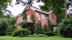 | Bentonville West Central Avenue Historic District | 0.4 miles | 1992 |
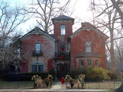 | Craig-Bryan House | 0.4 miles | 1988 |
| National Archives record | The nomination case file for reference 87002336 in Record Group 79. |
| Wikipedia article | Community-written account of this property, licensed CC BY-SA. |
| Benton County | All 162 listed properties in this county. |