BlockBefore

Lloyd England Hall

Listed on the National Register of Historic Places in 1997.

From the record

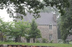
“Lloyd England Hall is a historic building at the northwest corner of 6th and Missouri Streets, on the grounds of Camp Joseph T. Robinson, an Arkansas National Guard base in North Little Rock, Arkansas.”

Wikipedia article Arkansas National Guard Museum, CC BY-SA 4.0.

One of 383 National Register listings published here for Pulaski County · listed in 1997 · category: Building.

Sources: the Wikipedia article · the National Register database, National Park Service

The listing

  • What is counted as historic. The nomination lists 1 building as contributing to the listing.
  • Address. Jct. of Missouri Ave. and 6th St., NW corner, North Little Rock
  • When was it listed? May 1997
  • Category. building
  • Also known as. Thompson, Charles L., Design Collection TR
  • Township. Hill township
  • Architectural style. Art Deco architecture
  • Architect. Charles L. Thompson and associates
  • National Register reference number. 97000403 - assigned by the National Park Service when the property was listed.

Fires near this property

29 since 1998

Regional context, not property-specific evidence. The federal wildfire occurrence database lists 29 fires within 5 miles of Lloyd England Hall between 1998 and 2018, burning about 1,633 acres in total. None started naturally. 12 were recorded as arson. Distance is straight-line from the map coordinates, so a fire counted here may appear on a neighbouring settlement's page as well.

Reported cause Fires
Arson/incendiarism12
Missing data/not specified/undetermined7
Debris and open burning6
Smoking2
Equipment and vehicle use1
Recreation and ceremony1

The most recent of them, most recent first, with the day each was reported and the service that recorded it.

DateCause SizeReported by Name on the report
30 September 1999Arson/incendiarism1.0 acresArkansas Forestry Commissionnot named
26 September 2006Debris and open burning30 acresArkansas Forestry Commissionnot named
11 September 2013Missing data/not specified/undetermined1.0 acresArkansas Forestry Commissionnot named
7 August 1999Arson/incendiarism5.0 acresArkansas Forestry Commissionnot named
7 August 1999Arson/incendiarism2.0 acresArkansas Forestry Commissionnot named
28 August 2010Arson/incendiarism1.0 acresArkansas Forestry Commissionnot named
23 August 1999Missing data/not specified/undetermined1.0 acresArkansas Forestry Commissionnot named

Every fire recorded in Pulaski County

Mines and quarries near this property

9 within 5 miles

Regional context, not property-specific evidence. The federal mineral resources record lists 9 workings within 5 miles of Lloyd England Hall: 5 producers, 3 unknowns, 1 past producer. 5 still produce. What was taken out: Stone, Crushed/Broken, Sand and Gravel, Construction, Lead, Zinc, Copper, Gold. Distance is straight-line from the map coordinates, so a quarry counted here may appear on a neighbouring settlement's page as well.

Where SiteCommodity StatusRecorded
Construction Products DivisionVermiculiteProducer
Big Sandy No. 3Sand and Gravel, ConstructionProducer
Julius HessLead, Zinc, Copper, GoldUnknown
Kellog MineLead, Zinc, Copper, GoldUnknown
North Little Rock Plant and DredgeSand and Gravel, ConstructionProducer
Big Rock QuarryStone, Crushed/BrokenUnknown
Cabot QuarryStone, Crushed/BrokenProducer
Little Rock MillStone, Crushed/BrokenProducer
MaumelleStone, Crushed/BrokenPast Producer

Every working recorded in Pulaski County

Storms near this property

60 of 71 shown

Regional context, not property-specific evidence. The National Weather Service names North Little Rock, the town this property stands in, in 71 storm reports between 1994 and 2020: 29 hail, 26 thunderstorm wind, 11 flash flood, 3 lightning. The reports record 1 injury. Each account below is quoted exactly as the forecast office filed it, from the NOAA Storm Events Database, and each date opens the federal record of that event.

WhenEvent Place namedHarm What the report says
June 1998Thunderstorm WindNorth Little Rock1 hurtno account filed
August 2011LightningNorth Little Rock$175,000Lightning struck a house on East C Ave. in the Park Hill neighborhood of North Little Rock, setting it on fire. The house was badly damaged. A firefighter was injured battling the blaze.
December 2009FloodNorth Little Rock$100,000Numerous streets were flooded in the Dark Hollow neighborhood of North Little Rock. Yards were covered in water, and the North Little Rock Fire Department evacuated about 20 people from their homes.
May 2015Flash FloodNorth Little Rock$50,000The intersection of Chester Street and La Harpe Boulevard west of the River Market area of Downtown Little Rock was flooded. Some cars had stalled in the high water.
July 2007Flash FloodNorth Little Rock$50,000The local emergency manager reported flooding on Riverfront Drive, Parker, and Pike Avenue. Several homes at 7th and Division were surrounded by water. Several vehicles stalled in the high water.
June 1998LightningNorth Little Rock$40,000no account filed
August 2012Thunderstorm WindNorth Little Rock$25,000A number of power lines were blown down in North Little Rock.
July 1999Thunderstorm WindNorth Little Rock$25,000no account filed
June 2009LightningNorth Little Rock$5,000A lightning strike took a chunk of concrete off the side column on North Little Rock High School's midsection tower.
June 1994Thunderstorm WindNorth Little Rock$5,000Several trees and power lines were blown down.
June 2020Thunderstorm WindNorth Little Rock-A tree and power lines were reported down at 5th and Orange St. in North Little Rock.
June 2019Thunderstorm WindNorth Little Rock-Tree limbs were blown down in Argenta.
May 2018Thunderstorm WindNorth Little Rock-Trained spotter reported 60 mph wind gusts on East 5th Street in North Little Rock.
July 2016Thunderstorm WindNorth Little Rock-Three large trees were uprooted at Dickey-Stephens Park in downtown North Little Rock.
March 2008HailNorth Little Rock-Hail covered the ground in North Little Rock, with the largest pieces being penny sized.
April 2008Flash FloodNorth Little Rock-Flash flooding was reported at the intersection of Riverfront Drive and Main Street.
June 2008Thunderstorm WindNorth Little Rock-A large pecan tree was down.
September 2007Flash FloodNorth Little Rock-Street flooding was reported at the 3600 block of John F. Kennedy Blvd. and on Pershing at the railroad underpass.
July 2007Flash FloodNorth Little Rock-A few streets were barricaded due to high water.
May 2006Flash FloodNorth Little Rock-Heavy rainfall, produced by slow moving thunderstorms, produced flash flooding in portions of North Little Rock. A number of streets in the city were impassible for several hours due to high water levels from runoff.
January 2005Thunderstorm WindNorth Little Rock-Thunderstorm winds downed some power lines and damaged the roof of a building in downtown North Little Rock.
July 2005Thunderstorm WindNorth Little Rock-Thunderstorm winds blew down a few trees and power lines about 3 miles east of North Little Rock.
August 2005Flash FloodNorth Little Rock-Heavy rains flooded several streets in North Little Rock.
June 2004Flash FloodNorth Little Rock-Several roads were briefly flooded to due heavy rainfall.
November 2004Flash FloodNorth Little Rock-Heavy rainfall produced significant street flooding in North Little Rock. A number of city streets were impassible due to high water and a police sub-station also flooded.
July 2003Thunderstorm WindNorth Little Rock-Thunderstorm winds blew down some large trees.
May 2003Thunderstorm WindNorth Little Rock-Thunderstorm winds downed several trees.
June 2001Thunderstorm WindNorth Little Rock-Thunderstorm winds downed some power lines.
July 1997Thunderstorm WindNorth Little Rock-Thunderstorm winds blew down some trees.
July 1995HailNorth Little Rock-Lightning struck a power pole in the parking lot at the National Weather Service. The lightning travelled into the office and damaged some electronic equipment.
April 1995Thunderstorm WindNorth Little Rock-Thunderstorm winds downed some power lines.
June 1995HailNorth Little Rock-Hail up to golf ball-size fell at a number of locations in the Little Rock metro area.
April 2011HailNorth Little Rock-no account filed
May 2006Thunderstorm WindNorth Little Rock-no account filed
April 2006Flash FloodNorth Little Rock-no account filed
November 2004Flash FloodNorth Little Rock-no account filed
May 2003HailNorth Little Rock-no account filed
March 2002HailNorth Little Rock-no account filed
February 2001HailNorth Little Rock-no account filed
May 2000Thunderstorm WindNorth Little Rock-no account filed
September 2000Thunderstorm WindNorth Little Rock-no account filed
April 1999HailNorth Little Rock-no account filed
February 1999HailNorth Little Rock-no account filed
June 1999Thunderstorm WindNorth Little Rock-no account filed
March 1999HailNorth Little Rock-no account filed
June 1999Thunderstorm WindNorth Little Rock-no account filed
June 1999HailNorth Little Rock-no account filed
June 1999Thunderstorm WindNorth Little Rock-no account filed
May 1998HailNorth Little Rock-no account filed
July 1998Thunderstorm WindNorth Little Rock-no account filed
April 1998HailNorth Little Rock-no account filed
June 1998HailNorth Little Rock-no account filed

Every storm recorded in Pulaski County

Map coverage status

No historic map-sheet match is published for this property yet. That does not mean no map exists. This record needs a coordinate-quality review before it can be joined to a sheet boundary. Browse the county's mapped places while that work is pending.

Listed places nearby

6 within 8 miles

Other National Register properties close enough to walk or drive between, ordered by distance from this one. Both positions come from the same geocoding pass that matched these properties to their map sheets.

Photograph PropertyDistance Listed
St. Joseph's Home1.1 miles1976
Amboy Overpass1.7 miles1995
Dr. Charles H. Kennedy House2.3 miles2017
Burns Park Golf Center2.7 miles2022
Cherry-Luter Estate2.9 miles1992
Lakeshore Drive Bridge2.9 miles1990

Sources for this property

National Archives recordThe nomination case file for reference 97000403 in Record Group 79.
Wikipedia articleCommunity-written account of this property, licensed CC BY-SA.
Pulaski CountyAll 383 listed properties in this county.

Provenance

  • Listing record. National Park Service National Register of Historic Places, listed-properties dataset, current to 2026-05-22.
  • Map join. Address geocoded through the United States Census geocoder, then tested against the published boundary of every sheet in the USGS Historical Topographic Map Collection.
  • How this page is made. Listing fields come from federal records; map-sheet coverage is a labelled coordinate-to-boundary calculation, not a source-field claim.
  • Wildfire. Short, Karen C. 2022. Spatial wildfire occurrence data for the United States, 1992-2020 [FPA_FOD_20221014]. 6th Edition. Fort Collins, CO: Forest Service Research Data Archive. https://doi.org/10.2737/RDS-2013-0009.6 Collected with United States Government funding and usable without additional permissions or fees.
  • Mines and quarries. USGS Mineral Resources Data System (MRDS) https://mrdata.usgs.gov/mrds/ A work of the United States government, no copyright under 17 U.S.C. 105.
  • Storms. NOAA National Centers for Environmental Information, Storm Events Database https://www.ncei.noaa.gov/stormevents/ A work of the United States government, no copyright under 17 U.S.C. 105. Narratives are quoted verbatim from the National Weather Service report and are not edited or summarised.