 Block
Sunnyslope, Arizona
18 topographic sheets cover this place, the earliest surveyed in 1954 and the latest in 1988. It stands in the Phoenix census division. It lies in ZIP code area 85020. It lies near North Mountain. The Survey maps it on the Sunnyslope quadrangle.
On record in Sunnyslope
Buildings and businesses the archive holds for this place. Each opens its own page, with the source record it came from.
On the National Register within a mile 3 records
The National Register names another town for these. They stand within one mile of this settlement's coordinate.
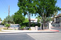 Bohn, Louis J. and Lee, Gertrude, Houselisted 2011 · 0.9 miles away
 Morgan, David-Bronson, Earl A., Houselisted 2011 · 1.0 miles away
- Casa Del Northernlisted 2022 · 0.9 miles away
Topographic sheets covering this place
9 surveys from 18 printed sheetsMatched by testing this settlement's coordinate against the published boundary of every sheet in the United States Geological Survey's historical collection. Each opens the scanned sheet at the Survey.
- 1954 USGS Phoenix quadrangle1:250000, 5 printings
- 1957 USGS Phoenix quadrangle1:250000
- 1958 USGS Phoenix quadrangle1:250000
- 1960 USGS Phoenix quadrangle1:250000
- 1965 USGS Sunnyslope quadrangle1:24000, 4 printings
- 1969 USGS Phoenix quadrangle1:250000, 2 printings
- 1971 USGS Phoenix quadrangle1:250000
- 1971 USGS Sunnyslope quadrangle1:24000
- 1988 USGS Phoenix North quadrangle1:100000, 2 printings






Fires near this place
2,016 since 1992Regional context, not property-specific evidence. The federal wildfire occurrence database lists 2,016 fires within 5 miles of Sunnyslope between 1992 and 2020, burning about 200 acres in total. 24 started naturally. 46 were recorded as arson. Distance is straight-line from the map coordinates, so a fire counted here may appear on a neighbouring settlement's page as well.
| Reported cause | Fires |
|---|---|
| Missing data/not specified/undetermined | 1937 |
| Arson/incendiarism | 46 |
| Natural | 24 |
| Power generation/transmission/distribution | 8 |
| Misuse of fire by a minor | 1 |
The most recent of them, most recent first, with the day each was reported and the service that recorded it.
| Date | Cause | Size | Reported by | Name on the report |
|---|---|---|---|---|
| 9 September 2019 | Missing data/not specified/undetermined | under an acre | Phoenix Fire Department | NOT NAMED |
| 9 September 2018 | Arson/incendiarism | under an acre | Phoenix Fire Department | 334516 |
| 9 September 2015 | Missing data/not specified/undetermined | under an acre | Arizona Department of Forestry and Fire Management - State Office | 154837 |
| 9 September 2012 | Missing data/not specified/undetermined | under an acre | Arizona Department of Forestry and Fire Management - State Office | AZ-122597 |
| 9 September 2011 | Missing data/not specified/undetermined | under an acre | Arizona Department of Forestry and Fire Management - State Office | AZ-111670 |
| 9 September 2011 | Missing data/not specified/undetermined | under an acre | Arizona Department of Forestry and Fire Management - State Office | AZ-111669 |
| 9 September 2010 | Missing data/not specified/undetermined | under an acre | Arizona Department of Forestry and Fire Management - State Office | AZ-101905 |
| 9 September 2010 | Missing data/not specified/undetermined | under an acre | Arizona Department of Forestry and Fire Management - State Office | AZ-101906 |
Settlements close enough to share some of these fires:
Mines and quarries near this place
10 of 29 shownRegional context, not property-specific evidence. The federal mineral resources record lists 29 workings within 5 miles of Sunnyslope: 10 past producers, 9 unknowns, 6 occurrences, 3 prospects. 1 still produces. What was taken out: Mercury, Sand and Gravel, Construction, Gold, Kyanite. Distance is straight-line from the map coordinates, so a quarry counted here may appear on a neighbouring settlement's page as well.
| Where | Site | Commodity | Status | Recorded |
|---|---|---|---|---|
| Cram's Gold Standard Prospect | Mercury, Silver, Copper, Gold | Past Producer | Vein | |
| Crushed Granite Operation Madison | Stone, Crushed/Broken | Producer | ||
| Marion | Gold, Silver, Bromine | Unknown | ||
| Mercury Group | Mercury, Copper | Past Producer | Cinnabar | |
| Nita Jean | Stone | Unknown | ||
| Rico Group | Mercury, Copper, Silver | Past Producer | 1916 | |
| Rico Mercury-Pat.#4047 | Mercury, Silver, Copper | Past Producer | 1916 | |
| Seal Rock Group | Kyanite, Mica, Mercury | Occurrence | Cinnabar, Kyanite, Mica | |
| Sealrock Group | Mercury, Mica, Kyanite | Unknown | ||
| Silica Occurrence | Silica | Occurrence | Quartz |
Storms near this place
41 since 1998Regional context, not property-specific evidence. The National Weather Service names Sunnyslope in 41 storm reports between 1998 and 2025: 30 thunderstorm wind, 6 flash flood, 2 hail, 1 heavy rain. No death or injury is recorded in these reports. Each account below is quoted exactly as the forecast office filed it, from the NOAA Storm Events Database, and each date opens the federal record of that event.
| When | Event | Place named | Harm | What the report says |
|---|---|---|---|---|
| July 2021 | Thunderstorm Wind | Sunnyslope | $200,000 | Multiple photos and videos on social media and reports from broadcast media of at least 14 downed utility power poles along 35th Avenue between Dunlap Avenue and Cactus Road in Phoenix due to strong winds from a severe warned thunderstorm. The downed poles and lines also knocked over street signs and street lamps, disrupted traffic, and caused a power outage for the area that took more than a day to be restored. Additionally, several large trees were uprooted or snapped in and around Cortez Park at 35th Ave and Dunlap Ave and a metal carport reportedly blew more than a block away near 35th Ave and Peoria Ave. Wind gusts were estimated around 55-65 mph. Timing estimated from radar. No injuries were reported. |
| July 2008 | Flash Flood | Sunnyslope | $200,000 | Streets and highways became flooded and some road closures were reported after rainfall rates exceeded 2 inches per hour in the heaviest storms. One spotter in East Mesa had a total of 2.50 inches. |
| August 2015 | Thunderstorm Wind | Sunnyslope | $100,000 | Thunderstorms raked the north central portion of the greater Phoenix metropolitan area during the afternoon hours on August 27th; due to a favorable combination of enhanced instability and wind fields aloft, the stronger storms were able to generate strong damaging microburst winds. Some of the areas that were especially hard hit were northern communities such as north Phoenix and North Mountain Park. According to local broadcast media reports, at 1600MST gusty winds estimated to be as high as 80 mph produced significant structural damage to a mobile home park located about 1 mile southeast of the Metro Center Mall. The damage was just east of Interstate 17 and north of West Dunlap Avenue. No injuries were reported. |
| August 2008 | Thunderstorm Wind | Sunnyslope | $100,000 | Trees and power lines down. |
| November 2019 | Tornado (EF0) | Sunnyslope | $40,000 | A powerful Pacific upper level low and associated cold front pushed east across the central and northern portions of the greater Phoenix metropolitan area during the early morning hours on November 29th. Due to elevated levels of wind shear and instability, the front spawned several tornadoes in the Phoenix area, including one that tracked through portions of North Phoenix and Deer Valley. The tornado moved to the northeast, across Lookout Mountain, and ended near the intersection of Loop 101 and Highway 51. The tornado, which was spotted by both the public and members of local broadcast media, touched down at about 0349MST and lifted back in the sky at 0359MST. The path length was nearly 10 miles. There were numerous reports of damage, some reported via social media. Broadcast media reported several trees downed along Thunderbird Road between 7th Avenue and 3rd Street. Media also reported several trees downed about 5 miles southeast of Deer Valley, and a carport was also destroyed. Additionally, at 0355MST the public reported that a carport was blown over onto some cars near the intersection of Bell Road and 15th Street. Fortunately there were no reports of injuries or fatalities due to the tornado. |
| July 2021 | Thunderstorm Wind | Sunnyslope | $25,000 | Broadcast report from local media showed a carport ripped away from a residence near Sahuaro Drive and 37th Drive due to strong winds in a severe warned thunderstorm. The carport flew into an alley behind the residence, knocking over a cinderblock wall and shattering the window of a residence on the other side of the alley. Winds were estimated around 55-65 mph and timing was estimated from radar. No injuries reported. |
| August 2010 | Thunderstorm Wind | Sunnyslope | $25,000 | A trained spotter reported that power poles were blown down at 19th Avenue and Dunlap. The poles were downed by thunderstorm microburst winds estimated to be in excess of 50 kt. |
| October 2018 | Flood | Sunnyslope | $20,000 | Copious amounts of tropical moisture spread north and into the greater Phoenix area during the morning hours on October 2nd; the moisture was associated with former hurricane Rosa. The moisture resulted in the development of widespread moderate to heavy showers which persisted into the afternoon hours, and affected the central portion of the Phoenix area including the community of Glendale. Heavy rains led to episodes of flash flooding and flooding, causing many road closures and resulting in some street damage. According to a report from a local newspaper, at 1435MST a sink hole developed at the intersection of 35th Avenue and Cactus Roads, about 5 miles northeast of Glendale. The sinkhole was caused by flash flooding that occurred earlier in the day and resulted in the intersection becoming closed. A Flood Warning had been issued earlier in the morning for the area, but the warning expired shortly before the sinkhole was reported by the paper. |
| August 2021 | Thunderstorm Wind | Sunnyslope | $17,000 | A portion of the roof of an apartment complex near 7th Avenue and Hatcher Road was torn of in strong winds and landed on an unoccupied parked car, causing damage. Nearby, multiple photos on social media showed several downed saguaros with one of them causing some damage to the front of a home near 12th Street and Northern Avenue. Winds estimated around 60 to 65 mph. No injuries were reported. |
| July 2021 | Thunderstorm Wind | Sunnyslope | $15,000 | Video on social media shows the roof of a residential home was partially torn off due to strong thunderstorm winds near 43rd Avenue and Cactus Road. Winds estimated around 60 mph and timing estimated from radar. No injuries reported. |
| July 2024 | Thunderstorm Wind | Sunnyslope | $10,000 | Large uprooted tree that fell between two houses in the area of West Beryl Avenue and North 38th Lane in Glendale. Wind gusts were estimated upwards of 60 mph. No injuries were reported. |
| August 2010 | Thunderstorm Wind | Sunnyslope | $10,000 | Power poles were blown down at 19th Ave and Dunlap. |
| July 2013 | Thunderstorm Wind | Sunnyslope | $6,000 | Strong thunderstorms developed across the northern portion of the greater Phoenix metropolitan area during the evening hours on July 19th. The storms generated gusty winds estimated to reach or exceed 65 mph. According to a trained weather spotter, at 1020 pm near 25th Avenue and West Happy Valley Road, 25 foot long tree branches were blown down. Winds estimated to be at least 50 mph were strong enough to shake vehicles in the area. In addition, another trained spotter 5 miles north of central Phoenix reported a large tree uprooted at 1020 pm by winds estimated to be at least 65 mph. The diameter of the trunk was estimated at 15 inches. The uprooted tree was located at the intersection of 16th Street and Greenway Parkway. A Severe Thunderstorm Warning was in effect for the area; it was issued at 1001 pm and continued until 1030 pm. |
| August 2025 | Thunderstorm Wind | Sunnyslope | $5,000 | Large tree fell on top of a couple parked vehicles and caused damage to a carport at Las Brisas Condominiums near 7th Street and Northern Ave in Phoenix with another large tree uprooted along a canal located near the condominium. Wind gusts were estimated upwards of 65 mph. No injuries were reported. |
| August 2022 | Thunderstorm Wind | Sunnyslope | $5,000 | Downed power poles reported in the area of West Cactus Road and North 30th Avenue in Phoenix. Timing estimated from radar. Wind gust was estimated at 60-70 mph. No injuries were reported. |
| December 2009 | Thunderstorm Wind | Sunnyslope | $5,000 | Three lare trees snapped and blown down onto a road near 32nd Street and Greenway. |
| November 2025 | Thunderstorm Wind | Sunnyslope | $2,000 | Downed power lines leading to power outage reported in the area of North 31st Avenue to North 23rd Avenue and Northern Avenue to West Maryland Avenue in Glendale. Based on radar evidence and surface observations, wind gusts were estimated upwards of 40 mph. Saturated loose grounds from previous rainfall likely made power lines more susceptible to go down with sub-severe winds. Timing estimated from radar. No injuries reported. |
| July 2024 | Thunderstorm Wind | Sunnyslope | $2,000 | Entire section of a brick wall blown down and large tree limbs snapped off in a residential complex located in the area of North 40th Avenue and West Peoria Avenue in Glendale. Wind gusts were estimated upwards of 60 mph. No injuries were reported. |
| July 2024 | Thunderstorm Wind | Sunnyslope | $2,000 | Palm tree fell over powerlines in the area of North 39th Avenue and West Peoria Avenue in Glendale. Wind gusts were estimated upwards of 60 mph. No injuries were reported. |
| August 2021 | Thunderstorm Wind | Sunnyslope | $2,000 | A photo on social media showed a large uprooted tree down on some power lines near 15th Avenue and Glendale Avenue. No injuries were reported. |
| August 2019 | Flash Flood | Sunnyslope | $2,000 | Scattered thunderstorms developed across the northern portions of the greater Phoenix area during the evening hours on August 28th. Some of the stronger storms, with peak rain rates in excess of one inch per hour, affected communities such as Deer Valley and north Phoenix. The locally heavy rain was sufficient to produce an episode of flash flooding. According to local broadcast media, at 2215MST flash flooding caused the road to be closed on West Thunderbird Road eastbound near north 26th Avenue. This was about 4 miles south of Deer Valley. The flooding resulted in multiple vehicles becoming stranded in the flood waters. Fortunately there were no injuries reported. A Flash Flood Warning had been issued for the area at 2215MST. |
| October 2018 | Flash Flood | Sunnyslope | $2,000 | Copious amounts of deep tropical moisture spread into the greater Phoenix area during the morning hours on October 2nd; the moisture was associated with former hurricane Rosa. The deep moisture resulted in widespread moderate to heavy showers. Many locations picked up 2 to 3 inches of rain during this event with much of the rain occurring in the morning. The heavy rain led to numerous episodes of flash flooding including many road closures across the central and northern portion of the Phoenix area. According to the Arizona Department of Highways, at 0732MST flash flooding resulted in a road closure at the intersection of Interstate I-17 and Peoria Avenue, about 5 miles northeast of Glendale. Additionally it was reported that one of the underpasses was flooded. No reports of accidents were received. A very large Flash Flood Warning was issued at 0730MST and it remained in effect until 1030MST; the warning included the area around Glendale. |
| August 2016 | Thunderstorm Wind | Sunnyslope | $2,000 | Thunderstorms developed across portions of the greater Phoenix metropolitan area during the evening hours on August 20th, and the stronger storms generated gusty and damaging outflow winds which impacted the town of Glendale. According to a report from the public, at 1830MST strong outflow winds downed a large tree near a hotel located about 5 miles northeast of Glendale and near the MetroCenter Mall just west of Interstate 17. The winds were estimated to be at least 60 mph in strength. The downed tree was reported by staff at the hotel. |
| October 2010 | Thunderstorm Wind | Sunnyslope | $2,000 | A trained weather spotter at 7th Avenue and Camelback Road reported that strong gusty thunderstorm winds damaged a plastic patio roof and blew down a 2 inch diameter tree branch. The spotter estimated winds to be in excess of 40 mph. |
| August 2008 | Thunderstorm Wind | Sunnyslope | $2,000 | Power lines down near 7th Street and Northern. |
| August 2025 | Thunderstorm Wind | Sunnyslope | $1,000 | A very large tree uprooted near the area of 3rd street and Northern Avenue in Phoenix. Wind gusts were estimated upwards of 65 mph. No injuries were reported. |
| July 2024 | Thunderstorm Wind | Sunnyslope | $1,000 | Large tree uprooted in the area of North 39th Avenue and West Peoria Avenue in Glendale. Wind gusts were estimated upwards of 60 mph. No injuries were reported. |
| August 2023 | Thunderstorm Wind | Sunnyslope | $1,000 | Large uprooted tree in the area of North Central Avenue and East Northern Avenue in Phoenix. Wind gusts were estimated of up to 60 mph. No injuries were reported. |
| August 2022 | Thunderstorm Wind | Sunnyslope | $1,000 | Social media picture showed a large tree uprooted alongside a home located on the intersection of West Cinnabar Avenue and North 33rd Avenue in Glendale. Timing estimated from radar. Winds were estimated at 55-60 mph. No injuries were reported. |
| August 2008 | Thunderstorm Wind | Sunnyslope | $1,000 | Large branches blown from trees. |
| August 2022 | Hail | Sunnyslope | - | Nickel size hail reported near the area of West Cactus Road and North 28th Drive in Glendale. No damages or injuries were reported. |
| August 2021 | Flash Flood | Sunnyslope | - | Public report of flooding along 23rd Avenue between Dunlap Avenue and Northern Avenue. Video shows the intersection of 23rd Avenue and Butler Drive flooded with at least 6 inches of water. No damages or injuries were reported. |
| August 2021 | Thunderstorm Wind | Sunnyslope | - | Photos on social media showed a large tree approximately 40-50 feet tall snapped in half near 35th Avenue and Peoria Avenue. No injuries were reported. |
| August 2021 | Flash Flood | Sunnyslope | - | A Maricopa County Flood Control District stream gage along Cave Creek at Cactus Road recorded flow climbing above alarm stage, impacting nearby low-lying areas. At 1632MST, the gage crested at 11.14 feet and 1,567 CFS. No damage or injuries were reported. |
| September 2019 | Thunderstorm Wind | Sunnyslope | - | Thunderstorms developed across the northern and central portions of the greater Phoenix area, including the community of Glendale, during the afternoon hours on September 1. Some of the storms produced gusty damaging outflow winds estimated to be up to 60 mph in strength. According to a report from the public, at 1720MST large tree limbs up to 16 inches in diameter were snapped near 7th Avenue and Northern Avenue, about 6 miles east of Glendale. Gusty thunderstorm outflow winds estimated at 60 mph downed the branches. |
| November 2019 | Thunderstorm Wind | Sunnyslope | - | A cold front passing through the central portions of the greater Phoenix area during the early morning on November 29th led to some strong and gusty winds. At 0350MST a mesonet weather station 5 miles northeast of Glendale, or near the intersection of Interstate 17 and Dunlap Avenue, measured a wind gust to 63 mph. Thunderstorms were present and associated with the front, and likely contributed to the strong gust. |
| October 2015 | Hail | Sunnyslope | - | Scattered thunderstorms moved across the greater Phoenix metropolitan area, including the community of Glendale, during the late morning hours on October 20th. Due in part to cold temperatures aloft, the stronger storms were able to generate large hail. At 1132MST a trained spotter just west of the Metro Center Mall estimated hailstones up to one inch in diameter at the intersection of 35th Avenue and Peoria Avenue. About 15 minutes earlier, another spotter 3 miles northeast of the Glendale Sports Complex estimated hailstones with diameters up to nearly 0.90 inches. Finally, at 1208MST another trained spotter estimated one inch diameter hail at the intersection of 75th Avenue and Bethany Home Road in Glendale. None of the spotters reported any damage due to the large hail. |
| September 2014 | Flash Flood | Sunnyslope | - | During the early afternoon hours on September 27th, a line of strong thunderstorms moved east across the greater Phoenix metropolitan area. In addition to bringing strong wind, the storms produced very heavy rain with rain rates in excess of 2 inches per hour. The heavy rains affected North Mountain, and led to flash flooding along Interstate 17 about 1 mile north of the Metro Center Mall. According to a trained weather spotter, at about 1530MST, flash flooding caused 3 to 4 feet of water to accumulate under the underpass of Interstate 17, creating extremely hazardous conditions for motorists. Fortunately, no injuries were reported as a result of the flooding. Although a Flash Flood Warning was not issued for the area, Urban and Small Stream Flood Advisories were in effect beginning at 1424MST and continuing through 1930MST. |
| August 2014 | Heavy Rain | Sunnyslope | - | Thunderstorms developed across the northern portions of the greater Phoenix area during the evening hours on August 1st and they affected communities such Glendale, Deer Valley and North Mountain as well as the Interstate 17 corridor. The stronger storms produced locally heavy rainfall with rain rates well in excess of one inch per hour. At 2141MST, a trained weather spotter 1 mile west of Metrocenter Mall in North Mountain measured 0.75 inches of rain within 45 minutes. He reported urban flooding with water curb to curb and running a few feet into some of the yards in the area. Additionally, at 2146MST another trained spotter 2 miles north of Glendale measured 1.36 inches of rain within 45 minutes. The heavy rain resulted in the issuance of multiple Urban and Small Stream Advisories for the area, which remained in effect into the early morning hours on August 2nd. |
| July 2010 | Thunderstorm Wind | Sunnyslope | - | Deer Valley airport recorded a gust from the southwest at 61 mph. The heavy rain reduced the visibility to a mere 1/4 mile. |
| July 1998 | Thunderstorm Wind | Sunnyslope | - | Power lines down. |
Nearest settlements
The eight closest, with where each one stands in the county. Distances are straight-line, computed from the Geographic Names Information System coordinates.
| Map | Place | Distance | Sheets |
|---|---|---|---|
| Palmas Royale | 1.2 miles | 18 | |
| The Pointe | 1.3 miles | 18 | |
| Skyline Heights | 1.6 miles | 18 | |
| Stony Mountain Villas | 2.5 miles | 18 | |
| The Preserve | 2.5 miles | 18 | |
| Estate Monterra | 2.7 miles | 18 | |
| Villa Novena | 2.8 miles | 18 | |
| Claremont Place | 2.9 miles | 18 |
Provenance
This settlement is recorded in the Geographic Names Information System as feature 11974. The sheet list is computed by point-in-boundary test against the United States Geological Survey's historical topographic inventory. Both are works of the United States government and carry no copyright under 17 U.S.C. 105.
Wildfire. Short, Karen C. 2022. Spatial wildfire occurrence data for the United States, 1992-2020 [FPA_FOD_20221014]. 6th Edition. Fort Collins, CO: Forest Service Research Data Archive. https://doi.org/10.2737/RDS-2013-0009.6 Collected with United States Government funding and usable without additional permissions or fees.
Mines and quarries. USGS Mineral Resources Data System (MRDS) https://mrdata.usgs.gov/mrds/ A work of the United States government, no copyright under 17 U.S.C. 105.
Storms. NOAA National Centers for Environmental Information, Storm Events Database https://www.ncei.noaa.gov/stormevents/ A work of the United States government, no copyright under 17 U.S.C. 105. Narratives are quoted verbatim from the National Weather Service report and are not edited or summarised.