
BlockBefore
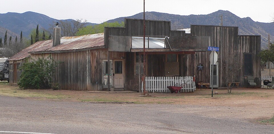
Photograph of J.H. Smith Grocery Store and Filling Station
Photograph by Ammodramus, CC0 1.0. Via Wikimedia Commons.

J.H. Smith Grocery Store and Filling Station

Listed on the National Register of Historic Places in 2004.

From the record

“Smith Grocery Store and Filling Station, at 1835 Old Ranch Rd. in Dragoon, Arizona, was built in 1915. It was listed on the National Register of Historic Places in 2004.”

Wikipedia article J.H. Smith Grocery Store and Filling Station, CC BY-SA 4.0.

One of 76 National Register listings published here for Cochise County · listed in 2004 · category: Building.

Sources: the Wikipedia article · the case file at the National Archives · the National Register database, National Park Service

The listing

  • What is counted as historic. The nomination lists 1 building as contributing to the listing.
  • Listed as. Smith, J.H., Grocery Store and Filling Station - the National Register files a house under its owner's surname.
  • Address. 1835 Old Ranch Rd., Dragoon, 85609
  • When was it listed? July 2004
  • Category. building
  • Census division. Benson
  • National Register reference number. 04000720 - the number the National Park Service assigned this property when it was listed, and the key its nomination file is catalogued under at the National Archives.

Fires near this property

177 since 1992

Regional context, not property-specific evidence. The federal wildfire occurrence database lists 177 fires within 5 miles of J.H. Smith Grocery Store and Filling Station between 1992 and 2020, burning about 22,017 acres in total. 35 started naturally. 5 were recorded as arson. Distance is straight-line from the map coordinates, so a fire counted here may appear on a neighbouring settlement's page as well.

Reported cause Fires
Missing data/not specified/undetermined94
Natural35
Equipment and vehicle use20
Debris and open burning7
Railroad operations and maintenance6
Arson/incendiarism5
Smoking5
Recreation and ceremony3
Misuse of fire by a minor2

The most recent of them, most recent first, with the day each was reported and the service that recorded it.

DateCause SizeReported by Name on the report
28 September 2000Natural4.0 acresArizona Department of Forestry and Fire Management - State OfficeGUNNISON
21 September 1999Equipment and vehicle useunder an acreArizona Department of Forestry and Fire Management - State OfficeOXYGEN
19 September 1994Missing data/not specified/undeterminedunder an acreArizona Department of Forestry and Fire Management - State Officenot named
14 September 2004Equipment and vehicle use5.0 acresArizona Department of Forestry and Fire Management - State OfficeREST AREA
12 September 2005Missing data/not specified/undeterminedunder an acreArizona Department of Forestry and Fire Management - State OfficeAPPRENTICE
29 August 2015Missing data/not specified/undetermined1.8 acresArizona Department of Forestry and Fire Management - State OfficeTOWERS
28 August 2019Missing data/not specified/undetermined9.8 acresArizona Department of Forestry and Fire Management - Southeast DistrictTOUCHSTONE
25 August 2011Natural1,632 acresCoronado National ForestFOURR

Every fire recorded in Cochise County

Mines and quarries near this property

10 of 85 shown

Regional context, not property-specific evidence. The federal mineral resources record lists 85 workings within 5 miles of J.H. Smith Grocery Store and Filling Station: 53 past producers, 12 occurrences, 12 prospects, 6 producers. 6 still produce. What was taken out: Tungsten, Copper, Stone, Crushed/Broken, Copper, Silver. Distance is straight-line from the map coordinates, so a quarry counted here may appear on a neighbouring settlement's page as well.

Where SiteCommodity StatusRecorded
Apache Yellow QuarriesMarble, Dimension, Stone, Crushed/BrokenPast Producer1909, 1953
Banks MineTungsten, Copper, Lead, Zinc, Fluorine-FluoritePast ProducerHuebnerite, Scheelite
Banks MineTungsten, Fluorine-Fluorite, Zinc, Lead, CopperPast Producer
Bluebird MineTungsten, Copper, QuartzPast Producer1898
Bluebird MineTungsten, Copper, Bismuth, BerylliumPast Producer1898, 1900
Buena Vista MineLead, Silver, CopperPast Producer1914, 1937
Burrel Claim GroupCopper, Lead, Silver, Tungsten, ZincPast Producer
Burro PitSilica, Copper, SilverPast Producer1960, 1970
Centurion Area Small MinesTungsten, Copper, SilverPast ProducerScheelite
Dividend TunnelTungsten, Copper, Beryllium, BismuthPast Producer

Every working recorded in Cochise County

Storms near this property

10 since 2008

Regional context, not property-specific evidence. The National Weather Service names Dragoon, the town this property stands in, in 10 storm reports between 2008 and 2025: 5 flash flood, 4 thunderstorm wind, 1 hail. The reports record 1 death. Each account below is quoted exactly as the forecast office filed it, from the NOAA Storm Events Database, and each date opens the federal record of that event.

WhenEvent Place namedHarm What the report says
August 2018Flash FloodDragoon1 killed, $10,000Heavy rain of 1.5 to 2 inches fell over a two hour period over and just east of the 2017 Lizard Fire Burn Scar. A motorist drown when his car became stuck in flood waters on Cochise Stronghold Road a mile south of Dragoon Road.
July 2018Thunderstorm WindDragoon$11,000Thunderstorm winds knocked down seven power poles along Dragoon Rd forcing it to close for a several hours.
August 2021Thunderstorm WindDragoon$10,000Four power poles were downed along Dragoon Rd.
July 2025Flash FloodDragoon$2,000A trained spotter reported flash flooding across roadway. With a nearby measured rainfall of 1.18 inches in 30 minutes.
July 2010Thunderstorm WindDragoon$1,000A trained spotter reported wind damage to awnings of a residence near Dragoon. The Willcox sheriff reported a horse was killed near Cochise, after a downed power line electrocuted the animal.
August 2024Thunderstorm WindDragoon-Personal weather station estimate of 60 mph gust.
July 2022Flash FloodDragoon-Heavy rain of 1.5 in 1 hour caused flash flooding and the closure of Dragoon Rd. south of Interstate 10.
September 2016Flash FloodDragoon-Thunderstorms produced brief heavy rain that caused 6 to 12 inches of water to flow over Dragoon Road and Old Ranch Road.
July 2008Flash FloodDragoon-A trained spotter reported flooding on Highway 191 near Pearce.
July 2018HailDragoon-no account filed

Every storm recorded in Cochise County

Map coverage status

No historic map-sheet match is published for this property yet. That does not mean no map exists. This record needs a coordinate-quality review before it can be joined to a sheet boundary. Browse the county's mapped places while that work is pending.

Sources for this property

National Archives recordThe nomination case file for reference 04000720 in Record Group 79.
Wikipedia articleCommunity-written account of this property, licensed CC BY-SA.
Cochise CountyAll 76 listed properties in this county.

Provenance

  • Listing record. National Park Service National Register of Historic Places, listed-properties dataset, current to 2026-05-22.
  • Map join. Address geocoded through the United States Census geocoder, then tested against the published boundary of every sheet in the USGS Historical Topographic Map Collection.
  • How this page is made. Listing fields come from federal records; map-sheet coverage is a labelled coordinate-to-boundary calculation, not a source-field claim.
  • Wildfire. Short, Karen C. 2022. Spatial wildfire occurrence data for the United States, 1992-2020 [FPA_FOD_20221014]. 6th Edition. Fort Collins, CO: Forest Service Research Data Archive. https://doi.org/10.2737/RDS-2013-0009.6 Collected with United States Government funding and usable without additional permissions or fees.
  • Mines and quarries. USGS Mineral Resources Data System (MRDS) https://mrdata.usgs.gov/mrds/ A work of the United States government, no copyright under 17 U.S.C. 105.
  • Storms. NOAA National Centers for Environmental Information, Storm Events Database https://www.ncei.noaa.gov/stormevents/ A work of the United States government, no copyright under 17 U.S.C. 105. Narratives are quoted verbatim from the National Weather Service report and are not edited or summarised.