 Block
From the record
One of 467 National Register listings published here for Maricopa County · listed in 2017 · category: Building.
Sources: the National Register database, National Park Service
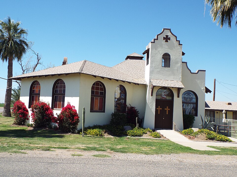
Listed on the National Register of Historic Places in 2017.
One of 467 National Register listings published here for Maricopa County · listed in 2017 · category: Building.
Sources: the National Register database, National Park Service
Regional context, not property-specific evidence. The federal wildfire occurrence database lists 254 fires within 5 miles of Liberty Methodist Episcopal Church, South between 1993 and 2020, burning about 820 acres in total. 10 started naturally. 9 were recorded as arson. Distance is straight-line from the map coordinates, so a fire counted here may appear on a neighbouring settlement's page as well.
| Reported cause | Fires |
|---|---|
| Missing data/not specified/undetermined | 225 |
| Natural | 10 |
| Arson/incendiarism | 9 |
| Power generation/transmission/distribution | 3 |
| Debris and open burning | 3 |
| Equipment and vehicle use | 3 |
| Smoking | 1 |
The most recent of them, most recent first, with the day each was reported and the service that recorded it.
| Date | Cause | Size | Reported by | Name on the report |
|---|---|---|---|---|
| 8 September 2015 | Missing data/not specified/undetermined | under an acre | Arizona Department of Forestry and Fire Management - State Office | 154014 |
| 7 September 2010 | Missing data/not specified/undetermined | under an acre | Arizona Department of Forestry and Fire Management - State Office | AZ-101018 |
| 30 September 2011 | Missing data/not specified/undetermined | under an acre | Arizona Department of Forestry and Fire Management - State Office | AZ-110709 |
| 27 September 2017 | Missing data/not specified/undetermined | under an acre | Goodyear Fire Department | not named |
| 27 September 2013 | Missing data/not specified/undetermined | under an acre | Arizona Department of Forestry and Fire Management - State Office | AZ-131996 |
| 26 September 2015 | Missing data/not specified/undetermined | under an acre | Arizona Department of Forestry and Fire Management - State Office | 153890 |
| 25 September 2010 | Missing data/not specified/undetermined | under an acre | Arizona Department of Forestry and Fire Management - State Office | AZ-100999 |
| 24 September 2018 | Natural | under an acre | Buckeye Fire Department | 354310 |
Regional context, not property-specific evidence. The federal mineral resources record lists 3 workings within 5 miles of Liberty Methodist Episcopal Church, South: 1 past producer, 1 producer, 1 unknown. 1 still produces. What was taken out: Sand and Gravel, Construction. Distance is straight-line from the map coordinates, so a quarry counted here may appear on a neighbouring settlement's page as well.
| Where | Site | Commodity | Status | Recorded |
|---|---|---|---|---|
| Cotton Lane Pit | Sand and Gravel, Construction | Unknown | ||
| Portable Crusher, King Material | Sand and Gravel, Construction | Past Producer | ||
| Western Sand & Rock | Sand and Gravel, Construction | Producer |
Regional context, not property-specific evidence. The National Weather Service names Buckeye, the town this property stands in, in 25 storm reports between 1993 and 2022: 20 thunderstorm wind, 3 funnel cloud, 1 lightning, 1 flood. The reports record 1 injury. Each account below is quoted exactly as the forecast office filed it, from the NOAA Storm Events Database, and each date opens the federal record of that event.
| When | Event | Place named | Harm | What the report says |
|---|---|---|---|---|
| August 1996 | Thunderstorm Wind | Buckeye | 1 hurt | no account filed |
| August 1998 | Thunderstorm Wind | Buckeye | $150,000 | Winds took down 6 power poles, and forced the closure of I-10 for 1 1/2 hours. A squad car from the Buckeye Police Department received minor damage when crushed by a falling power pole. Two private planes from Pierce Aviation were destroyed and several other planes were damaged by high winds. The roof of the administration building was damaged by the storm. |
| August 2022 | Thunderstorm Wind | Buckeye | $50,000 | Local broadcast showed footage of significant damage in the Buckeye area, including roofs partially torn off and a destroyed RV. No other specific details were received. No injuries were reported. |
| July 2005 | Thunderstorm Wind | Buckeye | $50,000 | About 41 power poles blown down by strong winds along route 85 between Buckeye and Gila Bend. |
| July 1999 | Thunderstorm Wind | Buckeye | $30,000 | High winds tore off a portion of a roof and pushed over a camper on Van Buren Street east of Palo Verde Road. In addition, power poles were blown down just outside of Buckeye. |
| August 2016 | Thunderstorm Wind | Buckeye | $15,000 | Thunderstorms with gusty outflow winds developed across portions of the greater Phoenix metropolitan area during the evening hours on August 10th and some of the stronger storms affected the community of Buckeye. According to a report from local law enforcement, a thunderstorm 1 mile southeast of Buckeye produced microburst winds that downed one power pole as well as several trees. Wind gusts were estimated to be as high as 65 mph. The thunderstorm damage occurred near the intersection of Highway 85 and South Miller Road. |
| August 2008 | Lightning | Buckeye | $10,000 | Brush fire was started by lightning and grew to about 425 acres. No structures were involved in the fire. |
| August 2003 | Thunderstorm Wind | Buckeye | $10,000 | no account filed |
| July 2022 | Thunderstorm Wind | Buckeye | $5,000 | Images from the Buckeye Police Department showed downed trees and power lines in Downtown Buckeye. Winds were estimated at 60 mph. Timing estimated from radar. No injuries were reported. |
| August 1993 | Thunderstorm Wind | Buckeye | $5,000 | Thunderstorms downed power lines and caused minor damage to a home. |
| August 2016 | Flood | Buckeye | - | Thunderstorms with locally heavy rain developed across the greater Phoenix metropolitan area during the evening hours on August 10th and the heavier showers exhibited peak rain rates approaching 2 inches per hour. Some of the heavier showers occurred over the community of Buckeye which led to some flooding of roads across the town. At 2040MST the Buckeye Police Department reported that several roads in the area were closed due to flooding. Flash flooding did not occur. An Urban and Small Stream Flood Advisory was initially issued for the area, starting at 2011MST and it was upgraded to a Flood Warning at 2045MST. The Flood Warning expired at 2245MST. |
| April 2004 | Funnel Cloud | Buckeye | - | Brief funnel cloud. |
| August 1998 | Thunderstorm Wind | Buckeye | - | Also, a report of .62 inch rain with the storm in 21 minutes. |
| July 1998 | Thunderstorm Wind | Buckeye | - | Ham radio tower blown over by winds, power lines down. |
| July 1997 | Thunderstorm Wind | Buckeye | - | Shingles were blown off roofs and awnings were damaged at several homes. |
| September 1997 | Thunderstorm Wind | Buckeye | - | About 30 power poles downed near Patterson Road. |
| August 1995 | Thunderstorm Wind | Buckeye | - | A tree was blown over onto a car. |
| September 1994 | Thunderstorm Wind | Buckeye | - | Thunderstorm winds blew down power poles. One half of a roof was blown off a mobile home. |
| August 2004 | Thunderstorm Wind | Buckeye | - | no account filed |
| March 2001 | Funnel Cloud | Buckeye | - | no account filed |
| February 1998 | Funnel Cloud | Buckeye | - | no account filed |
| August 1997 | Thunderstorm Wind | Buckeye | - | no account filed |
| August 1997 | Thunderstorm Wind | Buckeye | - | no account filed |
| August 1997 | Thunderstorm Wind | Buckeye | - | no account filed |
| September 1996 | Thunderstorm Wind | Buckeye | - | no account filed |
3 papers published in this town, digitised by the Library of Congress and free to read: 1,458 issues, 7,880 pages. Every page is searchable, so a name or a street can be looked for directly in what the town printed about itself at the time.
| Newspaper | Published |
|---|---|
| Buckeye Valley News and Buckeye Review | 1935 to 1950 |
| Buckeye Valley News | 1912 to 1935 |
| Buckeye Valley News and Continuation of the Buckeye Review | 1935 |
No historic map-sheet match is published for this property yet. That does not mean no map exists. This record needs a coordinate-quality review before it can be joined to a sheet boundary. Browse the county's mapped places while that work is pending.
Other National Register properties close enough to walk or drive between, ordered by distance from this one. Both positions come from the same geocoding pass that matched these properties to their map sheets.
| Photograph | Property | Distance | Listed |
|---|---|---|---|
 | Buckeye Union High School School A-Wing | 5.2 miles | 2009 |
| Buckeye Woman's Club | 5.3 miles | 2021 |
| National Archives record | The nomination case file for reference 100001752 in Record Group 79. |
| Maricopa County | All 467 listed properties in this county. |