 Block
From the record
One of 467 National Register listings published here for Maricopa County · listed in 2018 · category: Building.
Sources: the National Register database, National Park Service
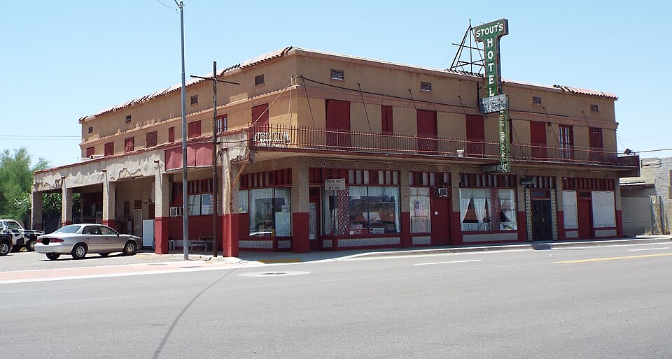
Listed on the National Register of Historic Places in 2018.
One of 467 National Register listings published here for Maricopa County · listed in 2018 · category: Building.
Sources: the National Register database, National Park Service
Regional context, not property-specific evidence. The federal wildfire occurrence database lists 53 fires within 5 miles of Stout's Hotel between 1993 and 2020, burning about 637 acres in total. 2 started naturally. 1 was recorded as arson. Distance is straight-line from the map coordinates, so a fire counted here may appear on a neighbouring settlement's page as well.
| Reported cause | Fires |
|---|---|
| Missing data/not specified/undetermined | 41 |
| Smoking | 6 |
| Natural | 2 |
| Debris and open burning | 2 |
| Railroad operations and maintenance | 1 |
| Arson/incendiarism | 1 |
The most recent of them, most recent first, with the day each was reported and the service that recorded it.
| Date | Cause | Size | Reported by | Name on the report |
|---|---|---|---|---|
| 18 September 1999 | Smoking | under an acre | Arizona Department of Forestry and Fire Management - State Office | BEND |
| 3 August 2018 | Natural | 15 acres | Arizona Department of Forestry and Fire Management - Central District | CITRUS |
| 8 July 2019 | Missing data/not specified/undetermined | under an acre | Buckeye Fire Department | NOT NAMED |
| 8 July 2019 | Missing data/not specified/undetermined | under an acre | Buckeye Fire Department | NOT NAMED |
| 6 July 2003 | Smoking | under an acre | Arizona Department of Forestry and Fire Management - State Office | AFTER |
| 3 July 2020 | Missing data/not specified/undetermined | under an acre | Arizona Department of Forestry and Fire Management - Central District | BUTTERFIELD |
| 25 July 2015 | Missing data/not specified/undetermined | under an acre | Arizona Department of Forestry and Fire Management - State Office | 154024 |
| 21 July 2014 | Missing data/not specified/undetermined | under an acre | Arizona Department of Forestry and Fire Management - State Office | AZ-141291 |
Regional context, not property-specific evidence. The federal mineral resources record lists 2 workings within 5 miles of Stout's Hotel: 1 producer, 1 past producer. 1 still produces. What was taken out: Sand and Gravel, Construction. Distance is straight-line from the map coordinates, so a quarry counted here may appear on a neighbouring settlement's page as well.
| Where | Site | Commodity | Status | Recorded |
|---|---|---|---|---|
| Gila Ready Mix Pit #1 | Sand and Gravel, Construction | Past Producer | ||
| Screening Plant Yavapai Materials | Sand and Gravel, Construction | Producer |
Regional context, not property-specific evidence. The National Weather Service names Gila Bend, the town this property stands in, in 32 storm reports between 1993 and 2025: 17 thunderstorm wind, 10 flash flood, 2 heavy rain, 1 tornado. No death or injury is recorded in these reports. Each account below is quoted exactly as the forecast office filed it, from the NOAA Storm Events Database, and each date opens the federal record of that event.
| When | Event | Place named | Harm | What the report says |
|---|---|---|---|---|
| September 2010 | Thunderstorm Wind | Gila Bend | $100,000 | Sheriff's Office and DPS reported that 20 power poles were blown down near the intersection of Watermelon Road and old U.S. Highway 80, just outside of Gila Bend. |
| August 2005 | Thunderstorm Wind | Gila Bend | $100,000 | As many as 12 electric utility power poles were blown down by severe thunderstorm winds. The storm winds also damaged the roof of the Paloma school building, and toppled a large tree onto a house. |
| May 1993 | Thunderstorm Wind | Gila Bend | $50,000 | Straight line winds snapped off about 20 power poles, blew shingles off the roof of the Super 8 motel, and damaged a storage shed. Power was off for much of this area for most of the day. |
| November 2019 | Flash Flood | Gila Bend | $20,000 | Widespread showers and isolated thunderstorms developed across the central deserts southwest of Phoenix during the evening hours on November 19th. The locally heavy rain resulted in an episode of flash flooding near the town of Gila Bend. At 1930MST a member of the public reported that a vehicle was stuck in a low water crossing about 2 miles to the east of Gila Bend. There were no reports of injuries to the trapped motorist. |
| September 2022 | Flash Flood | Gila Bend | $10,000 | SR-238 was closed in its entirety between Gila Bend and SR-347 due to significant flooding. The Maricopa Fire and Medical Crew as well as the Goodyear Fire Department in a collective effort had to rescue approximately 32 people in stranded vehicles. No injuries were reported. |
| July 2021 | Thunderstorm Wind | Gila Bend | $10,000 | Multiple RVs were damaged or displaced after strong to severe winds impacted the Sonoran Desert RV Park. 10 RVs were moved 5 to 6 feet and one was knocked over on its side. Additionally, one RV had windows broken and another had a cracked glass door. Winds estimated based on damage and timing based on radar. No injuries were reported. |
| August 2015 | Thunderstorm Wind | Gila Bend | $10,000 | Scattered thunderstorms developed across south central Arizona during the evening hours on August 30th, and some of them affected the town of Gila Bend. The stronger storms produced gusty and damaging outflow winds estimated to be at least 60 mph in strength. According to a trained weather spotter in the town of Gila Bend, at 1846MST gusty outflow winds snapped some power lines and this resulted in a power outage in town. |
| May 2012 | Thunderstorm Wind | Gila Bend | $10,000 | An upper level low moving east across southern Arizona spread moisture into south central Arizona and led to scattered thunderstorms during the afternoon and evening hours on May 9th. Some of the storms in the Gila Bend area produced damaging microburst winds with peak gusts estimated to be at least 60 knots. As reported by the local utility company, at approximately 615 PM the gusty winds downed a tree which blocked traffic on Pima Road and Highway 85. Construction debris from Interstate 8 and Bypass 85 was strewn about by the strong winds. In addition, power lines were downed by sustained winds reported to be in excess of 45 mph and this left most of the town of Gila Bend without power. |
| July 2018 | Thunderstorm Wind | Gila Bend | $5,000 | Isolated thunderstorms developed over the central deserts west of Phoenix during the evening hours on July 8th, and some of them produced gusty and damaging outflow winds that were at least 50 mph in strength. According to a trained weather spotter in Gila Bend, gusty outflow winds downed power lines and uprooted a tree in the town of Gila Bend. The downed power lines caused about half of the town to lose power as well as landline telephone service. No injuries were reported due to the downed lines. |
| October 2018 | Flash Flood | Gila Bend | $5,000 | Copious amounts of tropical moisture spread north and into southwest Maricopa County during the morning hours on October 2nd; the moisture was associated with former hurricane Rosa. The moisture led to widespread moderate to heavy showers and flash flooding around the town of Gila Bend. According to Maricopa County officials, at 0700MST flash flooding in the Sand Tank Wash resulted in the closure of both Watermelon Road and Indian Road. No accidents were reported due to the flooding. A Flash Flood Warning was issued for the area starting at 0550MST and it remained in effect through 0915MST. |
| August 2013 | Flash Flood | Gila Bend | $5,000 | Strong thunderstorms developed across portions of southwest Maricopa county during the evening hours, and they affected the area around Gila Bend. Due in part to lingering tropical moisture, the storms were able to generate locally heavy rains which led to flash flooding. At 1845MST the Department of Highways reported that Highway 238 east of Gila Bend was closed due to flash flooding. A Flash Flood Warning was issued for the area at 1836MST and it continued until 2030MST. No accidents or injuries were reported due to the flash flooding. |
| May 2025 | Flash Flood | Gila Bend | - | Intersection of State Route 85 and Maricopa Road in Gila Bend was closed due to flooding. Timing estimated from the radar. No damages nor injuries were reported. |
| October 2025 | Flash Flood | Gila Bend | - | State Route 85 ramp in Gila Bend closed due to flooding. Timing estimated from radar. No damages or injuries reported. |
| January 2024 | Flood | Gila Bend | - | Highway 238 initially closed from Mileposts 32-38 due to flooding. Approximately four hours later, the closure along the highway extended to Gila Bend. No damages or injuries were reported. |
| August 2022 | Flash Flood | Gila Bend | - | SR-238 was closed entirely from Gila Bend to SR 347 due to flooding. Timing estimated from radar. No damages or injuries were reported. |
| September 2022 | Flash Flood | Gila Bend | - | SR-238 closed between Milepost 4 and 24 due to flooding. No damages or injuries were reported. |
| July 2021 | Flash Flood | Gila Bend | - | Thunderstorms produced locally heavy rainfall late in the evening on the 9th near midnight across southern portions of Maricopa County and western portions of Pinal County. According to the Arizona Department of Transportation, the flood prone Highway 238 was closed due to flooding. No injuries or damage was reported as a result of the flooding. |
| October 2015 | Thunderstorm Wind | Gila Bend | - | Isolated thunderstorms developed across south central Arizona during the early afternoon hours on October 16th, and the stronger storms generated gusty outflow winds in excess of 60 mph. One such storm affected the community of Gila Bend. At 1301MST, the official ASOS weather station at the Gila Bend airport measured a wind gust to 62 mph. |
| August 2011 | Thunderstorm Wind | Gila Bend | - | Thunderstorms in the Gila Bend area during the late afternoon hours on August 3rd produced strong and gusty winds. The official Gila Bend AWOS weather station recorded a peak gust of 50 knots at 527 pm. |
| July 2011 | Thunderstorm Wind | Gila Bend | - | The official weather station at Gila Bend reported a peak wind gust of 57 knots at 730 pm, associated with the haboob moving westward across the central deserts. Visibility was measured at 1/16 of a mile in dense blowing dust. |
| September 2010 | Heavy Rain | Gila Bend | - | A trained spotter near Gila Bend measured a total of 0.90 inches of rainfall in a 30 minute period. The heavy rain prompted issuance of an urban and small stream flood advisory for the Gila Bend area. |
| September 2008 | Thunderstorm Wind | Gila Bend | - | Shingles were blown off homes, and a few trees were uprooted. |
| August 2006 | Thunderstorm Wind | Gila Bend | - | Rancher reported 18 power poles down. |
| August 2005 | Flash Flood | Gila Bend | - | DPS reported flooding on route 85. |
| August 2005 | Heavy Rain | Gila Bend | - | Trained spotter in Gila Bend reported a rainfall of 1/2 inch in 30 minutes. An automatic rain gauge at Hassayampa reported 1.38 inches of rain in one hour. |
| August 2001 | Thunderstorm Wind | Gila Bend | - | A large thunderstorm complex developed over northwest Maricopa County and moved to the south and southwest. The thunderstorm induced gust front, at times over 60 miles long, west to east, caused widespread electric power outages in the Gila Bend area south to Ajo in west Pima County. In the immediate Gila Bend area, thirty-eight 230kv poles downed, and thirty-nine 69kv poles downed. A substation was damaged as well as telephone lines. The reported wind gust of 66 knots was recorded at the Gila Bend municipal airport at 0245. As the gust front moved further to the south and southwest, a total of 140 power poles were blown over as reported by the Arizona Public Service. Electric power services were disrupted up to 5 days. |
| July 1995 | Tornado (F0) | Gila Bend | - | A flight service employee reported that a funnel cloud briefly touched the ground as a tornado in open country south of Gila Bend. |
| July 2005 | Funnel Cloud | Gila Bend | - | no account filed |
| August 1997 | Thunderstorm Wind | Gila Bend | - | no account filed |
| August 1997 | Thunderstorm Wind | Gila Bend | - | no account filed |
| August 1996 | Thunderstorm Wind | Gila Bend | - | no account filed |
| August 1996 | Thunderstorm Wind | Gila Bend | - | no account filed |
No historic map-sheet match is published for this property yet. That does not mean no map exists. This record needs a coordinate-quality review before it can be joined to a sheet boundary. Browse the county's mapped places while that work is pending.
Other National Register properties close enough to walk or drive between, ordered by distance from this one. Both positions come from the same geocoding pass that matched these properties to their map sheets.
| Photograph | Property | Distance | Listed |
|---|---|---|---|
| Gila Bend Overpass | 1.1 miles | 1988 |
| National Archives record | The nomination case file for reference 100002980 in Record Group 79. |
| Maricopa County | All 467 listed properties in this county. |