 Block
From the record
One of 140 National Register listings published here for Coconino County · listed in 1978 · category: District.
Sources: the case file at the National Archives · the National Register database, National Park Service
Listed on the National Register of Historic Places in 1978.
One of 140 National Register listings published here for Coconino County · listed in 1978 · category: District.
Sources: the case file at the National Archives · the National Register database, National Park Service
Regional context, not property-specific evidence. The federal wildfire occurrence database lists 7 fires within 5 miles of Lonely Dell Ranch Historic District between 1994 and 2017, burning about 12 acres in total. None started naturally. 3 were recorded as arson. Distance is straight-line from the map coordinates, so a fire counted here may appear on a neighbouring settlement's page as well.
| Reported cause | Fires |
|---|---|
| Arson/incendiarism | 3 |
| Recreation and ceremony | 3 |
| Power generation/transmission/distribution | 1 |
The most recent of them, most recent first, with the day each was reported and the service that recorded it.
| Date | Cause | Size | Reported by | Name on the report |
|---|---|---|---|---|
| 3 August 2000 | Arson/incendiarism | under an acre | Grand Canyon National Park | BRIDGE |
| 6 June 1995 | Recreation and ceremony | 2.0 acres | Glen Canyon National Recreation Area | 7.5 MILE C |
| 4 June 2017 | Recreation and ceremony | under an acre | Glen Canyon National Recreation Area | LEES FERRY CAMPGROUND |
| 13 June 2013 | Arson/incendiarism | 6.0 acres | Glen Canyon National Recreation Area | 8 MILE BAR |
| 11 June 2015 | Power generation/transmission/distribution | under an acre | Glen Canyon National Recreation Area | LEES FERRY |
| 29 May 1994 | Recreation and ceremony | under an acre | Grand Canyon National Park | KEATING |
| 2 February 2009 | Arson/incendiarism | 4.0 acres | Navajo Region Fire and Aviation Management | SOUTH PAGE 1 |
Regional context, not property-specific evidence. The federal mineral resources record lists 16 workings within 5 miles of Lonely Dell Ranch Historic District: 9 occurrences, 3 past producers, 2 prospects, 1 producer. 1 still produces. What was taken out: Uranium, Copper, Bentonite, Semiprecious Gemstone. Distance is straight-line from the map coordinates, so a quarry counted here may appear on a neighbouring settlement's page as well.
| Where | Site | Commodity | Status | Recorded |
|---|---|---|---|---|
| Foot of Echo Cliffs Area Bentonite | Bentonite | Occurrence | Bentonite | |
| Lees Ferry | Silica, Semiprecious Gemstone | Producer | Replacement | |
| Lees Ferry Gold | Gold | Occurrence | ||
| Lees Ferry Mercury | Mercury | Occurrence | ||
| Lehneer Prospect | Copper, Uranium | Prospect | ||
| Maggie-Baker Riley | Semiprecious Gemstone, Uranium, Vanadium | Past Producer | ||
| Redwing Prospect | Uranium, Copper | Prospect | ||
| B&B 1 & 11 | Copper | Unknown | ||
| El Pequito Mine | Uranium, Copper | Past Producer | Vein | |
| Lehneer Prospect | Uranium, Copper | Occurrence | Vein |
Regional context, not property-specific evidence. The National Weather Service names Page, the town this property stands in, in 21 storm reports between 1997 and 2025: 13 flash flood, 2 flood, 2 heavy rain, 2 thunderstorm wind. The reports record 11 deaths and 3 injuries. Each account below is quoted exactly as the forecast office filed it, from the NOAA Storm Events Database, and each date opens the federal record of that event.
| When | Event | Place named | Harm | What the report says |
|---|---|---|---|---|
| August 1997 | Flash Flood | Page | 11 killed, 1 hurt | Eleven hikers and tourists were drowned by a flash flood in a narrow slot canyon 5 miles southeast of Page. A severe thunderstorm 3 to 5 miles upstream produced very heavy rain causing a 10-30 foot wall of water to crash down Antelope Canyon. In the area of the flood fatalities the depth and width of Antelope Canyon varies from about 20 feet across and 30 feet deep to points where it is 200 feet deep but only two (2) feet across. It is a popular site for hiking and photography where access is via rope ladders controlled by Navajo Nation representatives. The eleven who died and a tour guide were warned not to enter the canyon because of the flood potential from an approaching thunderstorm. The tour guide alone survived after being carried several miles downstream by the flood. |
| August 2024 | Lightning | Page | 2 hurt | Two people were injured by lightning near the Rim Overlook at Horseshoe Bend. |
| July 2023 | Thunderstorm Wind | Page | $100,000 | Strong winds broke large tree limbs, uprooted trees, blew shingles off structures, and caused power outages for much of the city of Page. |
| July 2022 | Flash Flood | Page | $20,000 | Heavy rain caused flash flooding in Antelope Canyon. The popular tourist slot canyon was closed for at least a day so that the water could be removed and sand could be replaced. |
| September 2017 | Thunderstorm Wind | Page | $20,000 | A thunderstorm produce damaging winds in the Page area. The hanger at the Page Airport was damaged. The Jet Center windows were blown out by the winds. A few trees were uprooted. The Page ASOS recorded a peak wind gust of 56 MPH at 1238 PM MST. ||Multiple homes in the Champan Village area were damaged by flying debris and falling trees. Two power poles were destroyed when wind blown trees fell on them. This caused power outages in the area. |
| August 1997 | Flash Flood | Page | $10,000 | Power poles were knocked over by mudslides in the Wahweap area and street flooding was reported in Page. |
| July 1999 | Flood | Page | $1,000 | no account filed |
| August 2025 | Heavy Rain | Page | - | Public reported heavy rain near Glen Canyon Dam that closed the Chains and Hanging Gardens trailheads due to flooding. Rainfall was estimated at 0.5 inches. |
| July 2022 | Flash Flood | Page | - | A video of flash flooding in Antelope Canyon was posted on social media. |
| September 2021 | Flash Flood | Page | - | Heavy rain flooded a wash which created a waterfall over the rim and into Glen Canyon just below/south of Glen Canyon Dam. |
| August 2015 | Flash Flood | Page | - | A maintenance worker at the Lake Powell Tribal Park reported significant flooding in Antelope Canyon. Time estimated using radar data. |
| June 2015 | Heavy Rain | Page | - | Heavy rain from a thunderstorm caused water and mud to run over Highway 89 near Glen Canyon Bridge. The north bound lane was briefly closed (Estimated time). |
| August 2013 | Flash Flood | Page | - | A major flash flood hit Antelope Canyon with water hitting the underside of a bridge. The water in the normally dry slot canyon is over 40 feet in places. Flood waters in Honey Draw were running over State Route 99 and and State Highway 89. The water and mud flowed down State Highway 89 and into a gas station at Lake Powell Boulevard. The mud that was deposited in the parking lot was 12-18 inches deep and trapped vehicles. |
| August 2013 | Flash Flood | Page | - | Flash flooding was reported in Antelope Canyon southeast of Page. Eight to 12 inches of new sand was deposited in this popular slot canyon. |
| August 2010 | Flash Flood | Page | - | The tour company at Antelope Canyon reported flash flooding in the canyon after midnight. |
| July 2007 | Flash Flood | Page | - | Heavy rain from a thunderstorm produced a flash flood and mudslide on Copper Mind Road. |
| July 2006 | Flash Flood | Page | - | Antelope Canyon had 3 to 4 feet of water flowing through it Sunday evening. |
| October 2006 | Flash Flood | Page | - | An Antelope Canyon Tours employee reported a large amount of water flowing through the normally dry slot canyon. |
| August 2003 | Flash Flood | Page | - | A "massive" flash flood swept through Antelope Canyon near Page. Four feet of sand was removed from this slot canyon with even higher water levels. State Route 98 was flooded near mile post 307 and from mile post 300 to mile post 302. |
| August 1997 | Hail | Page | - | 0.75 inch diameter hail reported by the public. |
| October 1997 | Flood | Page | - | Heavy thunderstorm rains caused mudslides and flooding in the Wahweep area of Page, AZ closing Lakeshore Drive. |
No historic map-sheet match is published for this property yet. That does not mean no map exists. This record needs a coordinate-quality review before it can be joined to a sheet boundary. Browse the county's mapped places while that work is pending.
Other National Register properties close enough to walk or drive between, ordered by distance from this one. Both positions come from the same geocoding pass that matched these properties to their map sheets.
| Photograph | Property | Distance | Listed |
|---|---|---|---|
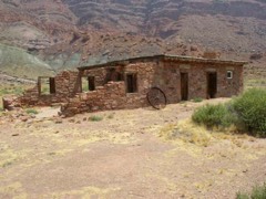 | Lee's Ferry and Lonely Dell Ranch | under 500 feet | 1997 |
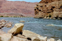 | Lees Ferry | 0.9 miles | 1976 |
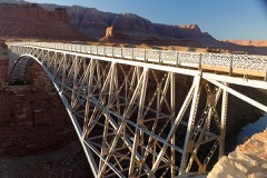 | Navajo Steel Arch Highway Bridge | 4.2 miles | 1981 |
| National Archives record | The nomination case file for reference 78000277 in Record Group 79. |
| Coconino County | All 140 listed properties in this county. |