
BlockBefore
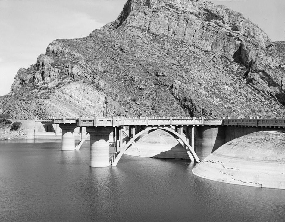
Photograph of Coolidge Dam
Photograph by Unknown, Public domain. Via Wikimedia Commons.

Coolidge Dam

Built in 1930. Listed on the National Register of Historic Places in 1981.

From the record

“The Coolidge Dam is a reinforced concrete multiple dome and buttress dam 31 miles (50 km) southeast of Globe, Arizona on the Gila River. Built between 1924 and 1928, the Coolidge Dam was part of the San Carlos Irrigation Project.”

Wikipedia article Coolidge Dam, CC BY-SA 4.0.

One of 43 National Register listings published here for Gila County · listed in 1981 · category: Structure · built in 1930.

Sources: the Wikipedia article · the case file at the National Archives · the National Register database, National Park Service

The listing

  • Address. SW of San Carlos, San Carlos
  • When was it listed? October 1981
  • Category. structure
  • When was it built? 1930
  • National Register reference number. 81000135 - the number the National Park Service assigned this property when it was listed, and the key its nomination file is catalogued under at the National Archives.

Fires near this property

50 since 1992

Regional context, not property-specific evidence. The federal wildfire occurrence database lists 50 fires within 5 miles of Coolidge Dam between 1992 and 2020, burning about 272 acres in total. 10 started naturally. 16 were recorded as arson. Distance is straight-line from the map coordinates, so a fire counted here may appear on a neighbouring settlement's page as well.

Reported cause Fires
Arson/incendiarism16
Missing data/not specified/undetermined16
Natural10
Misuse of fire by a minor5
Debris and open burning2
Equipment and vehicle use1

The most recent of them, most recent first, with the day each was reported and the service that recorded it.

DateCause SizeReported by Name on the report
8 September 1995Arson/incendiarism15 acresSan Carlos AgencyBLUE
3 August 2004Equipment and vehicle use1.5 acresSan Carlos AgencyWASTE
27 August 2005Arson/incendiarism1.0 acresSan Carlos AgencyKID
16 August 2020Natural123 acresSan Carlos AgencySC LAKE
16 August 1994Naturalunder an acreSan Carlos AgencyRABBIT II
13 August 1995Natural15 acresSan Carlos AgencyBORDERLINE
11 August 2003Missing data/not specified/undetermined2.0 acresSan Carlos AgencyARSON
8 July 1999Naturalunder an acreFort Apache AgencyPEPPER RDG

Every fire recorded in Gila County

Storms near this property

18 since 2000

Regional context, not property-specific evidence. The National Weather Service names San Carlos, the town this property stands in, in 18 storm reports between 2000 and 2025: 9 thunderstorm wind, 3 hail, 3 flash flood, 2 heavy rain. No death or injury is recorded in these reports. Each account below is quoted exactly as the forecast office filed it, from the NOAA Storm Events Database, and each date opens the federal record of that event.

WhenEvent Place namedHarm What the report says
January 2010FloodSan Carlos$200,000Numerous reports of flooding in Southern Gila County. Residents were evacuated along the wash south of San Carlos. Residents near Tonto Basin were stranded for several days after flows of about 60,000 cfs were measured along the Tonto Creek. By Monday, January 25th, the flow was down to about 550 cfs.
September 2012Flash FloodSan Carlos$100,000Scattered thunderstorms developed across portions of southern Gila county during the late afternoon hours on September 4th. Due to the very humid and unstable nature of the atmosphere, the storms generated excessive rainfall with peak rain rates in excess of 2 inches. The heavy rains affected San Carlos as well as State Route 170 east of the town. Radar indicated that up to 2 inches of rain fell north of San Carlos between 4 pm and 5 pm, and a Flash Flood Warning was issued at 425 pm. According to local law enforcement, at 515 pm flash flooding was occurring along State Route 170 in San Carlos. Multiple people were being rescued due to high and swiftly moving water crossing the highway.
August 2011Thunderstorm WindSan Carlos$100,000Strong thunderstorms affected the community of San Carlos during the late afternoon hours on August 12th. Damaging microburst winds were produced by the storms. According to local law enforcement personnel, gusty winds estimated to be around 60 knots blew down numerous power poles in and around San Carlos. In addition, the strong winds blew down a number of trees in the community.
July 2007Thunderstorm WindSan Carlos$50,000Roofing materials blown off several homes; mobile home damaged in White Rock, near San Carlos.
August 2015Thunderstorm WindSan Carlos$5,000Thunderstorms developed across southern Gila county during the early afternoon hours on August 7th and some of them produced gusty outflow winds measured as high as 60 mph. Some of the storms affected the area around San Carlos; according to local law enforcement strong gusty winds blew down live power lines in residential areas about 1 mile northeast of San Carlos. Locally heavy rain was also present, covering some of the roads and producing minor street flooding in the area.
August 2008Thunderstorm WindSan Carlos$2,000Power outage due to strong winds. Possible funnel cloud near mile marker 256 on highway 70.
September 2025Thunderstorm WindSan Carlos-Mesonet station QSCA3 San Carlos No. 1 in San Carlos measured a 62 mph peak gust.
August 2024Flash FloodSan Carlos-Sevenmile Wash rose approximately 2 ft, making low water crossings across the wash impassable. Timing estimated from radar estimated precipitation. No damages nor injuries were reported.
June 2024Thunderstorm WindSan Carlos-A 64 mph wind gust was measured at the San Carlos RAWS station. Timing estimated from radar.
July 2019Thunderstorm WindSan Carlos-Monsoon thunderstorms developed across the higher terrain of eastern Arizona, including southern Gila County, during late afternoon and evening hours on July 22. One of the stronger storms generated very gusty outflow winds that impacted the town of San Carlos. According to a mesonet weather station, a wind gust to 61 mph was recorded at 1814MST about 2 miles to the northeast of San Carlos. No damaged was reported due to the strong wind.
August 2015Thunderstorm WindSan Carlos-Scattered thunderstorms affected south central Arizona, including far southern Gila county, during the afternoon hours on August 7th. Some of the stronger storms produced gusty outflow winds in excess of 50 mph. According to the San Carlos RAWS weather station, a wind gust to 60 mph was measured at 1314MST.
July 2014HailSan Carlos-Strong thunderstorms developed across portions of southern Gila county during the evening hours on July 8th, and they affected the community of San Carlos. The storms produced locally heavy rain and large hail. According to local law enforcement, quarter sized hail, or hail 1 inch in diameter, was measured in San Carlos.
August 2011Heavy RainSan Carlos-Strong thunderstorms in the community of San Carlos produced locally heavy rainfall during the late afternoon and early evening hours on August 12th. Radar estimated that between 2 and 3 inches of rain fell across San Carlos, and according to local law enforcement personnel the rainfall led to flooding of streets across the community. Additionally, the heavy rain caused area washes to run heavily.
July 2008Flash FloodSan Carlos-Flooding along San Carlos river just south of San Carlos.
May 2007HailSan Carlos-Local police reported large hail.
July 2006Heavy RainSan Carlos-Radar estimated from 3/4 to 1 inch rainfall across mainly rural areas of Southern Gila County.
July 2003Thunderstorm WindSan Carlos-The San Carlos RAWS measured 58 MPH wind gusts.
August 2000HailSan Carlos-Large hail was reported from a lookout tower. Strong winds from nearby thunderstorms moved through San Carlos at about the same time.

Every storm recorded in Gila County

Map coverage status

No historic map-sheet match is published for this property yet. That does not mean no map exists. This record needs a coordinate-quality review before it can be joined to a sheet boundary. Browse the county's mapped places while that work is pending.

Sources for this property

National Archives recordThe nomination case file for reference 81000135 in Record Group 79.
Wikipedia articleCommunity-written account of this property, licensed CC BY-SA.
Gila CountyAll 43 listed properties in this county.

Provenance

  • Listing record. National Park Service National Register of Historic Places, listed-properties dataset, current to 2026-05-22.
  • Map join. Address geocoded through the United States Census geocoder, then tested against the published boundary of every sheet in the USGS Historical Topographic Map Collection.
  • How this page is made. Listing fields come from federal records; map-sheet coverage is a labelled coordinate-to-boundary calculation, not a source-field claim.
  • Wildfire. Short, Karen C. 2022. Spatial wildfire occurrence data for the United States, 1992-2020 [FPA_FOD_20221014]. 6th Edition. Fort Collins, CO: Forest Service Research Data Archive. https://doi.org/10.2737/RDS-2013-0009.6 Collected with United States Government funding and usable without additional permissions or fees.
  • Storms. NOAA National Centers for Environmental Information, Storm Events Database https://www.ncei.noaa.gov/stormevents/ A work of the United States government, no copyright under 17 U.S.C. 105. Narratives are quoted verbatim from the National Weather Service report and are not edited or summarised.