
BlockBefore
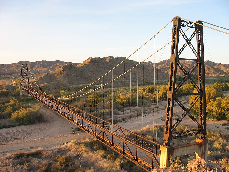
Photograph of McPhaul Suspension Bridge
Photograph by Kenneth, CC BY-SA 3.0. Via Wikimedia Commons.

McPhaul Suspension Bridge

Listed on the National Register of Historic Places in 1981.

From the record

“The McPhaul Suspension Bridge, sometimes known as Yuma, Arizona's Bridge to Nowhere, is a suspension bridge that used to carry a section of Arizona Route 95. The bridge is listed on the National Register of Historic Places.”

Wikipedia article McPhaul Suspension Bridge, CC BY-SA 4.0.

One of 58 National Register listings published here for Yuma County · listed in 1981 · category: Structure.

Sources: the Wikipedia article · the case file at the National Archives · the National Register database, National Park Service

The listing

  • What is counted as historic. The nomination lists 1 structure as contributing to the listing.
  • Address. W of Dome, Dome, 85365
  • When was it listed? August 1981
  • Category. structure
  • Also known as. Vehicular Bridges in Arizona MPS
  • Census division. Yuma
  • National Register reference number. 81000140 - the number the National Park Service assigned this property when it was listed, and the key its nomination file is catalogued under at the National Archives.

Fires near this property

108 since 1992

Regional context, not property-specific evidence. The federal wildfire occurrence database lists 108 fires within 5 miles of McPhaul Suspension Bridge between 1992 and 2020, burning about 526 acres in total. 2 started naturally. 3 were recorded as arson. Distance is straight-line from the map coordinates, so a fire counted here may appear on a neighbouring settlement's page as well.

Reported cause Fires
Missing data/not specified/undetermined55
Recreation and ceremony31
Debris and open burning10
Firearms and explosives use3
Arson/incendiarism3
Natural2
Fireworks2
Equipment and vehicle use1
Misuse of fire by a minor1

The most recent of them, most recent first, with the day each was reported and the service that recorded it.

DateCause SizeReported by Name on the report
8 September 2016Missing data/not specified/undetermined1.0 acresArizona Department of Forestry and Fire Management - State OfficeKINTER
7 September 2020Arson/incendiarismunder an acreColorado River DistrictBRIDGE
7 September 2013Naturalunder an acreColorado River DistrictNORTH GILA
7 September 2008Missing data/not specified/undeterminedunder an acreColorado River DistrictLEO
26 September 1992Fireworks1.0 acresColorado River DistrictMITTRY 2
22 September 2014Missing data/not specified/undetermined1.0 acresColorado River DistrictSIPHON
22 September 2005Missing data/not specified/undeterminedunder an acreColorado River DistrictBLASEDELL2
22 September 2005Missing data/not specified/undeterminedunder an acreColorado River DistrictBLASEDELL

Every fire recorded in Yuma County

Mines and quarries near this property

10 of 28 shown

Regional context, not property-specific evidence. The federal mineral resources record lists 28 workings within 5 miles of McPhaul Suspension Bridge: 15 past producers, 7 occurrences, 3 unknowns, 2 producers. 2 still produce. What was taken out: Gold, Silver, Copper, Copper, Gold, Silver. Distance is straight-line from the map coordinates, so a quarry counted here may appear on a neighbouring settlement's page as well.

Where SiteCommodity StatusRecorded
Adair Park PitSand and Gravel, ConstructionProducer
Arizona Lead Co MillFluorine-Fluorite, Lead, StonePast Producer
Dome ClinoptiloliteZeolites, BentoniteOccurrenceBentonite, Clinoptilolite
Golden Queen MineGold, Silver, Copper, Iron, Manganese, Gypsum-AnhydritePast Producer1937
Las Flores Mine GroupGold, Copper, Silver, ManganesePast Producer
Marble GullyMarble, DimensionPast ProducerMarble
McKay ProspectGold, Copper, IronOccurrenceGold, Hematite
Own CrewsStone, Crushed/BrokenProducer
UnknownTungstenProspect
UnknownZeolitesOccurrence

Every working recorded in Yuma County

Storms near this property

8 since 1997

Regional context, not property-specific evidence. The National Weather Service names Dome, the town this property stands in, in 8 storm reports between 1997 and 2025: 3 thunderstorm wind, 3 flash flood, 1 hail, 1 tornado. No death or injury is recorded in these reports. Each account below is quoted exactly as the forecast office filed it, from the NOAA Storm Events Database, and each date opens the federal record of that event.

WhenEvent Place namedHarm What the report says
August 2012Thunderstorm WindDome$45,000Isolated thunderstorms developed in the area around Yuma during the afternoon hours on August 12th. Due to the excessive heat and the relatively dry character of the atmosphere, the storms were able to generate strong, gusty and damaging microburst winds. According to a trained weather spotter, at 428 pm wind gusts estimated to be at least 60 knots caused 6 power poles to be blown down near county 6th Street and Avenue 18E. This location was approximately 4 miles east of Kinter.
August 2005Thunderstorm WindDome$10,000Power poles down.
October 2022Flash FloodDome$5,000A vehicle stalled in floodwaters along Aberdeen Road near Highway 95 and was assisted by the Yuma Fire Department. Timing estimated from radar. No injuries were reported.
September 2019Flash FloodDome$2,000Scattered showers and thunderstorms developed across the southwest deserts during the morning hours on September 23rd. Some of the stronger storms generated locally heavy rains that continued into the afternoon hours. Peak rain rates were well in excess of one inch per hour and the heavy rain resulted in an episode of flash flooding that occurred to the northeast of Yuma. According to a county official, at 1100MST flash flooding occurring 18 miles north of the town of Ligurta resulted in the closure of Highway 95 between mile markers 61 and 62. A Flash Flood Warning was not in effect at the time of the flooding. No accidents were reported due to the flash flooding.
September 2025Flash FloodDome-Reports of Aberdeen Rd. being impassable. No damages or injuries reported.
October 2018Tornado (EF0)Dome-Thunderstorms developed across portions of the southwest deserts during the afternoon hours on October 13th, and in addition to typical threats such as gusty wind, hail and heavy rain, one of the stronger storms generated a weak and short lived tornado near the community of Yuma. The tornado was spotted by a trained spotter, and it touched down at 1722MST. The weak tornado touched down about 10 miles north of the Fortuna Foothills, near Highway 95, and it only remained on the ground for 5 minutes. No damage or injuries were reported from this tornado. Typically, tornadoes are very rare across the lower Arizona deserts and when they do form, they are typically small, weak and short lived, as this one was.
August 2014HailDome-Strong thunderstorms developed across far southwest Arizona during the afternoon hours on August 21st, and they affected areas just to the northeast of Yuma. In addition to gusty winds, the stronger storms produced large hail. According to a meteorologist with the Yuma Proving Ground, large hail was measured about 6 miles to the north of Kinter, over open terrain to the northeast of Yuma. The diameter of the larger hailstones was measured to be one inch. No damage was reported due to the large hail.
August 1997Thunderstorm WindDome-Downed power lines on Dome Valley Road. A woman was trapped in her car due to the downed power lines. Further, 15 power poles were downed in Dome Valley.

Every storm recorded in Yuma County

Map coverage status

No historic map-sheet match is published for this property yet. That does not mean no map exists. This record needs a coordinate-quality review before it can be joined to a sheet boundary. Browse the county's mapped places while that work is pending.

Sources for this property

National Archives recordThe nomination case file for reference 81000140 in Record Group 79.
Wikipedia articleCommunity-written account of this property, licensed CC BY-SA.
Yuma CountyAll 58 listed properties in this county.

Provenance

  • Listing record. National Park Service National Register of Historic Places, listed-properties dataset, current to 2026-05-22.
  • Map join. Address geocoded through the United States Census geocoder, then tested against the published boundary of every sheet in the USGS Historical Topographic Map Collection.
  • How this page is made. Listing fields come from federal records; map-sheet coverage is a labelled coordinate-to-boundary calculation, not a source-field claim.
  • Wildfire. Short, Karen C. 2022. Spatial wildfire occurrence data for the United States, 1992-2020 [FPA_FOD_20221014]. 6th Edition. Fort Collins, CO: Forest Service Research Data Archive. https://doi.org/10.2737/RDS-2013-0009.6 Collected with United States Government funding and usable without additional permissions or fees.
  • Mines and quarries. USGS Mineral Resources Data System (MRDS) https://mrdata.usgs.gov/mrds/ A work of the United States government, no copyright under 17 U.S.C. 105.
  • Storms. NOAA National Centers for Environmental Information, Storm Events Database https://www.ncei.noaa.gov/stormevents/ A work of the United States government, no copyright under 17 U.S.C. 105. Narratives are quoted verbatim from the National Weather Service report and are not edited or summarised.