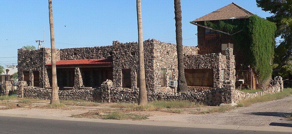
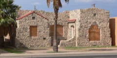
Built in 1927 (Pueblo Revival Style architecture). Listed on the National Register of Historic Places in 1985.
From the record
“Fisher Memorial Home was an historic structure located at 300 E. 8th Street in Casa Grande, Arizona. The building was included on the National Register of Historic Places, before being removed on January 31, 2019, having been destroyed by fire in April 2017.”
Wikipedia article Fisher Memorial Home, CC BY-SA 4.0.
One of 100 National Register listings published here for Pinal County · listed in 1985 · category: Building · built in 1927, Pueblo Revival Style architecture.
Architectural style. Pueblo Revival Style architecture
National Register reference number. 85000884 - assigned by the National Park Service when the property was listed.
Fires near this property
214 since 1993
Regional context, not property-specific
evidence. The
federal wildfire occurrence database
lists 214 fires within 5 miles of Fisher Memorial Home
between 1993 and 2020, burning about 238 acres in total. 9 started naturally. 4 were recorded as arson.
Distance is straight-line from the map coordinates, so a fire counted
here may appear on a neighbouring settlement's page as well.
Reported cause
Fires
Missing data/not specified/undetermined
156
Debris and open burning
17
Equipment and vehicle use
10
Smoking
10
Natural
9
Arson/incendiarism
4
Recreation and ceremony
2
Misuse of fire by a minor
2
Power generation/transmission/distribution
2
Railroad operations and maintenance
2
The most recent of
them, most recent first, with the day each was reported and the service
that recorded it.
Date
Cause
Size
Reported by
Name on the report
9 September 2015
Missing data/not specified/undetermined
under an acre
Arizona Department of Forestry and Fire Management - State Office
FLORENCE
5 September 2019
Missing data/not specified/undetermined
under an acre
Casa Grande Fire Department
NOT NAMED
29 September 2020
Missing data/not specified/undetermined
under an acre
Arizona Department of Forestry and Fire Management - State Office
not named
25 September 1995
Smoking
under an acre
Arizona Department of Forestry and Fire Management - State Office
not named
24 September 2005
Arson/incendiarism
under an acre
Arizona Department of Forestry and Fire Management - State Office
Regional context, not property-specific
evidence. The federal mineral resources record lists
17 workings within 5 miles of Fisher Memorial Home: 11 past producers, 4 producers, 1 occurrence, 1 prospect.
4 still produce. What was taken out: Sand and Gravel, Construction, Stone, Gypsum-Anhydrite. Distance is straight-line from the
map coordinates, so a quarry counted here may appear on a neighbouring
settlement's page as well.
Regional context, not property-specific
evidence. The National Weather Service names
Casa Grande, the town this property stands in, in 32 storm reports between 1993 and 2025: 21 thunderstorm wind, 3 hail, 3 flash flood, 2 heavy rain.
The reports record 2 deaths and 3 injuries. Each account below is quoted exactly as the forecast office
filed it, from the NOAA Storm Events Database, and each date
opens the federal record of that event.
A severe thunderstorm moved into the far northern part of the city of Casa Grande, and overturned a mobile home which pinned a small child underneath. The little girl later died of her injuries. The very strong thunderstorm winds also downed power lines and blew down a medium-size pine tree. Heavy rains also flooded part of Interstate 10 near mile post 190, and a subdivision had to be cordoned off due to high waters. (F03M)
Strong thunderstorms moved across the community of Casa Grande during the middle of the afternoon on August 3rd and they produced gusty and damaging outflow winds estimated to be at least 70 mph in strength. Local Casa Grande police reported significant storm damage about 2 miles northeast of Casa Grande; at least 6 power poles were downed along with 2 brick fences. In addition, several trees were knocked over. Fortunately there were no reports of injuries.
Scattered thunderstorms developed across the deserts of south central Arizona during the late afternoon hours on August 26th, and they affected Casa Grande as well as the surrounding areas. The atmosphere was moist and very unstable and this allowed the thunderstorms to produce strong and damaging winds. A trained weather spotter about 2 miles northeast of Casa Grande reported debris, including a basketball hoop, flying down the street due to very strong winds. Another trained spotter on the northeast side of Casa Grande reported damage at a Home Depot. Cars in the parking lot were damaged by heavy debris blown about by winds of at least 60 mph. Additionally, a co-op observer 4 miles northwest of Eloy reported that several trees were downed by strong winds. He also estimated wind gusts to be around 60 mph. Two Severe Thunderstorm Warnings were issued for these damaging wind events; the first was issued at 1726MST and expired at 1745MST. The second was issued at 1747MST and ran through 1845MST.
Strong thunderstorms with damaging microburst winds developed near the community of Casa Grande during the evening hours of July 5th. According to a public report, thunderstorm winds estimated to be in excess of 55 knots blew over a semi truck along Interstate 8 at Mile Marker 169. No injuries were reported.
Scattered thunderstorms developed across portions of northern Pinal county during the afternoon hours on August 26th, and they affected the area around Casa Grande. Lingering tropical moisture made the airmass very moist and unstable, and the thunderstorms quickly generated heavy rain which was sufficient to produce flash flooding. At 1820MST, a trained weather spotter just north of Casa Grande reported water rapidly flowing down his street and additional water was flooding into numerous backyards. At 1815MST, another trained spotter near Sacaton reported water flowing rapidly across streets west of Sacaton, which made area roads impassable for at least 30 minutes. A Flash Flood Warning was issued for the area at 1810MST and it continued through 2015MST.
Strong thunderstorms developed in the Casa Grande area during the late afternoon hours on July 31st. A trained weather spotter 2 miles east of Casa Grande reported an estimated wind gust to 65 mph. The strong microburst winds damaged the roof on a neighboring home.
Downed power lines along Thornton Road between Peters Road and Selma Highway in Casa Grande. Wind gusts were estimated at 55-60 mph. Timing estimated from radar. No injuries reported.
An overhead street sign was blown down in the area of Pinal Avenue and Florence Boulevard in Casa Grande. Wind gusts were estimated around 55 mph. No injuries were reported.
Numerous moderate to heavy showers developed across the deserts of northwest Pinal County during the morning hours on October 13th and some of them affected the community of Casa Grande. The showers were triggered by the approach of a strong Pacific low pressure system and the heavier showers experienced peak rain rates in excess of one inch per hour. At 0955MST a report from the general public was received that indicated curb to curb street flooding was occurring in a neighborhood in the town of Casa Grande. Significant flash flooding did not occur however and no accidents were reported.
Thunderstorms affected the central deserts of Arizona, including the community of Casa Grande, during the evening hours on August 11th and one of the stronger ones produced outflow winds in excess of 60 mph. At 2045MST a mesonet weather station 3 miles to the northwest of Casa Grande measured a peak wind gust of 65 mph. Shortly thereafter, at 2055MST the official Casa Grande airport AWOS weather station measured a wind gust of 59 mph.
Scattered to numerous showers, and isolated thunderstorms, developed across south central Arizona during the morning hours on July 4th, and they produced locally heavy rain which affected the communities of Casa Grande and Maricopa. Based on radar estimates and surrounding rain gage reports, rainfall in excess of one inch fell within a 3 hour period ending by 11:30 am. At 9:30 am, the Casa Grande Fire Department/Rescue reported local street flooding in Casa Grande with water 3-4 inches deep over area roads. Local media reported road closures from Murphy Road to White and Parker Road along the West Maricopa-Casa Grande Highway southeast of Maricopa, due to the locally heavy rainfall.
Thunderstorm winds bent a steel utility pole into a metal storage shed in the 2100 block of North Trekell Road. The winds damaged a 20- by 30-foot steel storage structure at Foxworth-Galbraith Lumber Company in the 2100 block of North Pinal Avenue and blew a shed in the Rancho Del Sol Mobile Home Park on North Trekell into a parked car. Several mobile homes in the area sustained damage. ARKANSAS, Central and North Central
A severe thunderstorm moved into the far northern part of the city of Casa Grande, and overturned a mobile home which pinned a small child underneath. The little girl later died of her injuries. The very strong thunderstorm winds also downed power lines and blew down a medium-size pine tree. Heavy rains also flooded part of Interstate 10 near mile post 190, and a subdivision had to be cordoned off due to high waters. (F03M)
1 paper published in this town,
digitised by the Library of Congress and free to read: 3 issues,
14 pages. Every page is searchable, so a name or a street can be
looked for directly in what the town printed about itself at the time.
No historic map-sheet match is published
for this property yet. That does not mean no map exists. This record needs
a coordinate-quality review before it can be joined to a sheet boundary.
Browse the county's mapped places while that work is
pending.
Listed places nearby
6 within 8 miles
Other National Register properties close
enough to walk or drive between, ordered by distance from this one. Both
positions come from the same geocoding pass that matched these properties
to their map sheets.
Listing record. National Park Service National Register of Historic Places, listed-properties dataset, current to 2026-05-22.
Map join. Address geocoded through the United States Census geocoder, then tested against the published boundary of every sheet in the USGS Historical Topographic Map Collection.
How this page is made. Listing fields come from federal records; map-sheet coverage is a labelled coordinate-to-boundary calculation, not a source-field claim.
Wildfire. Short, Karen C. 2022. Spatial wildfire occurrence data for the United States, 1992-2020 [FPA_FOD_20221014]. 6th Edition. Fort Collins, CO: Forest Service Research Data Archive. https://doi.org/10.2737/RDS-2013-0009.6 Collected with United States Government funding and usable without additional permissions or fees.
Mines and quarries. USGS Mineral Resources Data System (MRDS) https://mrdata.usgs.gov/mrds/ A work of the United States government, no copyright under 17 U.S.C. 105.
Storms. NOAA National Centers for Environmental Information, Storm Events Database https://www.ncei.noaa.gov/stormevents/ A work of the United States government, no copyright under 17 U.S.C. 105. Narratives are quoted verbatim from the National Weather Service report and are not edited or summarised.
 Block