 Block
From the record
One of 467 National Register listings published here for Maricopa County · listed in 1986 · category: Building.
Sources: the case file at the National Archives · the National Register database, National Park Service
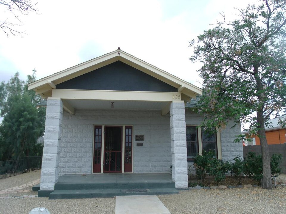
Listed on the National Register of Historic Places in 1986.
One of 467 National Register listings published here for Maricopa County · listed in 1986 · category: Building.
Sources: the case file at the National Archives · the National Register database, National Park Service
Regional context, not property-specific evidence. The federal wildfire occurrence database lists 56 fires within 5 miles of House at 185 Washington between 1993 and 2020, burning about 330 acres in total. 1 started naturally. 2 were recorded as arson. Distance is straight-line from the map coordinates, so a fire counted here may appear on a neighbouring settlement's page as well.
| Reported cause | Fires |
|---|---|
| Missing data/not specified/undetermined | 45 |
| Railroad operations and maintenance | 4 |
| Arson/incendiarism | 2 |
| Natural | 1 |
| Misuse of fire by a minor | 1 |
| Power generation/transmission/distribution | 1 |
| Debris and open burning | 1 |
| Equipment and vehicle use | 1 |
The most recent of them, most recent first, with the day each was reported and the service that recorded it.
| Date | Cause | Size | Reported by | Name on the report |
|---|---|---|---|---|
| 13 September 2019 | Missing data/not specified/undetermined | under an acre | Wickenburg Fire Department | NOT NAMED |
| 29 August 2020 | Missing data/not specified/undetermined | under an acre | Arizona Department of Forestry and Fire Management - State Office | not named |
| 18 August 2019 | Power generation/transmission/distribution | under an acre | Wickenburg Fire Department | NOT NAMED |
| 27 July 1995 | Railroad operations and maintenance | 9.0 acres | Arizona Department of Forestry and Fire Management - State Office | not named |
| 16 July 2019 | Missing data/not specified/undetermined | 22 acres | Phoenix District Office | TOWER ASSIST |
| 16 July 2019 | Arson/incendiarism | under an acre | Wickenburg Fire Department | NOT NAMED |
| 14 July 2003 | Equipment and vehicle use | under an acre | Phoenix District Office | TOWERS |
| 9 June 2017 | Missing data/not specified/undetermined | 6.0 acres | Phoenix District Office | MAMMOTH |
Regional context, not property-specific evidence. The federal mineral resources record lists 30 workings within 5 miles of House at 185 Washington: 10 occurrences, 7 past producers, 5 prospects, 4 unknowns. 4 still produce. What was taken out: Gold, Fluorine-Fluorite, Copper, Zeolites. Distance is straight-line from the map coordinates, so a quarry counted here may appear on a neighbouring settlement's page as well.
| Where | Site | Commodity | Status | Recorded |
|---|---|---|---|---|
| Copper Prince | Gold, Silver, Copper | Past Producer | ||
| Goddard Mining Co | Copper, Gold | Unknown | ||
| Lepidolite Occurrence | Lithium | Unknown | ||
| Quarry | Stone | Unknown | ||
| Sunset Prospect | Copper, Gold, Silver | Prospect | ||
| Bar Fx Ranch | Vermiculite | Occurrence | Vermiculite | |
| Bar Fx Ranch | Vermiculite | Occurrence | ||
| Burchfield Feldspar | Feldspar, Mica | Occurrence | Feldspar, Muscovite | |
| Burchfield Feldspar | Feldspar, Mica | Occurrence | ||
| Cochrane Property | Vanadium, Lead, Zinc, Copper | Occurrence |
Regional context, not property-specific evidence. The National Weather Service names Wickenburg, the town this property stands in, in 50 storm reports between 1996 and 2025: 26 flash flood, 15 thunderstorm wind, 5 hail, 3 heavy rain. The reports record 2 deaths. Each account below is quoted exactly as the forecast office filed it, from the NOAA Storm Events Database, and each date opens the federal record of that event.
| When | Event | Place named | Harm | What the report says |
|---|---|---|---|---|
| July 2012 | Flash Flood | Wickenburg | 1 killed | Scattered thunderstorms developed across south central Arizona during the afternoon hours on Saturday July 14th, and they produced locally heavy rainfall which led to episodes of flash flooding in the Wickenburg area. A Flash Flood Warning was issued for Wickenburg at about 5 pm in the afternoon. According to the Maricopa County Sheriff's Department, a 65 year old man died as he attempted to drive across the Hassayampa wash/river near Wickenburg. As he attempted to drive through the wash, the swiftly flowing water carried his vehicle about one quarter of a mile downstream and into some brush, causing him to drown. No other details were made available. In addition to the fatality, crews were dispatched to four water rescues during the evening hours on Saturday according to Kevin Pool of the Wickenburg Fire Department. One such rescue occurred north of town along US highway 93 in a neighborhood near a wash. In that incident the person was rescued from the top of his vehicle by sheriff's helicopter and taken to a hospital for observation. |
| August 2003 | Flash Flood | Wickenburg | 1 killed | Flash flood in Sols Wash swept the vehicle downstream from Vulture Mine Road |
| August 2014 | Flash Flood | Wickenburg | $300,000 | Thunderstorms developed across the northern portion of Maricopa county during the evening hours on August 25th, and some of the stronger storms affected the community of Wickenburg. The storms produced locally heavy rainfall with peak rain rates in excess of one inch per hour. The heavy rain led to both urban street flooding as well as flash flooding in the town of Wickenburg. According to a report from local broadcast media, flash flooding occurred at the Desert Cypress Mobile Home and RV park located along Constellation Road and El Recreo Drive. Flash flooding produced mild to severe damage to between 12 and 15 of the homes at the park. The Wickenburg Fire Department evacuated 11 people from the homes that experienced the most significant flooding. Fortunately, no injuries were reported due to the flooding. |
| August 1998 | Thunderstorm Wind | Wickenburg | $300,000 | A strong to severe complex of storms formed northeast of Wickenburg and moved to the southwest and intensified. The storms produced severe damage to at least 2 aircraft at the Wickenburg airport. About 6 power poles were blown down, and evaporative coolers were blown off roofs. Large tree limbs were broken off in Wickenburg. Sheriff's deputies rescued a boater and eight passengers on Lake Pleasant. |
| July 2007 | Flash Flood | Wickenburg | $100,000 | About 1.5 inches of rain in less than an hour resulted in flooding in Wickenburg. Torrential rainfall rates, about 2 inches per hour, fell in Phoenix. A roof of a central Phoenix Safeway store caved in due to the rainfall. Phoenix Fire Department rescued a 12 year-old from a flooded area near 35th Avenue and Loop 101. |
| September 2006 | Flash Flood | Wickenburg | $100,000 | Several roads reported flooded in town after torrential rainfall hit in a short period. One gauge indicated nearly 2 inches in 30 minutes. A wash overflowed its banks, flooding a nearby home with water up to 18 inches deep. |
| August 2014 | Thunderstorm Wind | Wickenburg | $25,000 | Strong thunderstorms developed in the Wickenburg area during the late afternoon hours on August 3rd, and they produced damaging microburst outflow winds estimated to be nearly 70 mph in strength. According to a trained weather spotter located in northwest Wickenburg, the microburst winds produced roof damage in downtown Wickenburg. A Severe Thunderstorm Warning was issued for Wickenburg at 1720MST and it continued until 1745MST. |
| July 2009 | Thunderstorm Wind | Wickenburg | $20,000 | Winds reached 55 to 65 mph in this area. One spotter reported tiles blown off his roof. |
| August 2017 | Thunderstorm Wind | Wickenburg | $15,000 | Thunderstorms developed across the town of Wickenburg during the late afternoon hours on August 10th and some of the stronger storms produced gusty and damaging microburst winds estimated to reach speeds as high as 70 mph. According to a trained weather spotter, at 1744MST the strong microburst winds downed multiple trees in the south part of Wickenburg including many pine trees estimated to be 40 feet in height. Fortunately the downed trees did not fall on anybody and no injuries were reported. A Severe Thunderstorm Warning was not issued. |
| August 2014 | Thunderstorm Wind | Wickenburg | $10,000 | Thunderstorms developed across the far northern portion of the greater Phoenix area during the evening hours on August 25th, and some of the stronger storms affected the community of Wickenburg. The storms produced gusty and damaging outflow winds, with peak gusts estimated to be at least 60 mph. A trained weather spotter 1 mile northeast of Wickenburg reported that strong outflow winds snapped off a large tree branch with a diameter of 18 inches. The branch fell, causing damage to both a roof and an automobile next to the house. The home was located at the intersection of Tegner Street and Genung Avenue. |
| July 2014 | Thunderstorm Wind | Wickenburg | $8,000 | Strong thunderstorms developed during the afternoon hours on July 6th, and they affected the community of Wickenburg. The storms produced damaging outflow winds with peak gusts estimated to be over 60 mph. According to a local Emergency Manager, the gusty winds blew down several large trees in Wickenburg. In addition, a trained weather spotter in the same area reported that two six inch diameter trees were blown over. |
| July 2017 | Thunderstorm Wind | Wickenburg | $5,000 | Strong thunderstorms developed near the town of Wickenburg during the late afternoon hours on July 15th. The storms produced gusty and damaging outflow winds, estimated to be as high as 60 mph. According to a trained weather spotter, at 1810MST the strong winds downed a 40 foot tall tree, which then fell over and blocked highway 60. No injuries were reported. A Severe Thunderstorm Warning was in effect for Wickenburg at the time; it was issued at 1755MST and was in effect through 1830MST. |
| August 2014 | Thunderstorm Wind | Wickenburg | $5,000 | Thunderstorms developed across far northern Maricopa county during the evening hours on August 25th, and some of them affected the community of Wickenburg. The stronger storms generated gusty and damaging outflow winds; according to a broadcast media report, wind gusts estimated to be nearly 60 mph downed power lines approximately 2 miles east of Wickenburg. |
| September 2006 | Thunderstorm Wind | Wickenburg | $5,000 | Eight large trees, more than a foot in diameter, blown down near downtown Wickenburg. |
| May 2001 | Thunderstorm Wind | Wickenburg | $5,000 | Winds damaged shingles, flipped a heavy table, and reduced visibility to near zero. |
| May 2023 | Thunderstorm Wind | Wickenburg | $1,000 | Saguaro tree uprooted in downtown Wickenburg. Winds were estimated at around 50 mph. No injuries were reported. |
| November 2025 | Flash Flood | Wickenburg | - | Constellation Rd at El Recreo Drive in Wickenburg was closed due to flooding. No damages or injuries reported. |
| March 2023 | Flash Flood | Wickenburg | - | Portions of Jack Burden Rd in Wickenburg closed due to flooding. No damages or injuries were reported. |
| March 2023 | Flash Flood | Wickenburg | - | A Maricopa County Flood Control District Gauge at Casandro Wash in Wickenburg registered flows going above alarm stage, which is 2.2 feet, at 20:03 MST. The flow reached a peak of 4.76 feet (343 cfs) at 20:30 MST and went below flood stage by 22:03 MST. This likely contributed to flooding along the inflow to Casandro Dam as well as small road crossings that intersect the wash. No damages or injuries were reported. |
| July 2021 | Flash Flood | Wickenburg | - | Hassayampa River Preserve closed several trails due to water/debris with a sudden rise in the Hassayampa River. Palm Lake in the reserve reportedly rose by 3 feet due to flood waters and video from the day after the heavy rain showed evidence of 1-3 feet of flow in the typically dry river bed. A USGS streamflow gage a few miles downstream measured a rapid 1 foot rise in 30 minutes. No damages or injuries were reported. |
| July 2021 | Flash Flood | Wickenburg | - | A Maricopa County Flood Control District streamflow gage on Powder House wash near Powder House Wash Road reached alarm stage and flood waters continued into and down Constellation Road and flooded the intersection with Jack Burden Road. A nearby rain gage measured 2.09 inches of rain in 56 minutes. The Public Works Department had to remove sand and debris from the road the following day. No damages or injuries were reported. |
| November 2019 | Flash Flood | Wickenburg | - | A powerful Pacific low pressure system moving slowly east across Arizona interacted with deep moisture to produce widespread moderate to heavy rain across western portions of Maricopa County during the morning hours on November 29th. Aided by frontal lift, isolated thunderstorms developed within the bands of rain, locally enhancing rain totals. The heavy rain led to an episode of flash flooding in the community of Wickenburg during the early morning hours. According to the Wickenburg fire and rescue department, flash flooding caused the vulture mine road to become closed at Sols Wash, about 3 miles to the northwest of Wickenburg. The actual time of the flooding was estimated to be 0351MST, based on data from a Maricopa County Flood Control District streamgage; the gage crested at 1.79 feet and travel time of the flood wave was used in estimating the exact time of flash flooding. There were no reports of accidents due to the flash flooding. |
| July 2018 | Flash Flood | Wickenburg | - | Scattered thunderstorms occurred over the far northern portion of Maricopa County, near and to the south of Wickenburg, during the evening hours on July 11th. The stronger storms produced very heavy rain with peak rain rates in excess of one inch per hour. The heavy rain led to flash flooding near and southeast of Wickenburg. Maricopa County Flood Control District gauges reported upwards of one inch of rain within one hour or less near Wickenburg and at 1915MST local emergency managers reported that flash flooding was imminent or occurring in Calamity Wash and the surrounding area. Severe street flooding in the area was also imminent. A Flash Flood Warning was issued for the area near and south of Wickenburg at 1830MST and it remained in effect until 2130MST. |
| August 2018 | Flash Flood | Wickenburg | - | Thunderstorms with locally heavy rain developed around the community of Wickenburg during the afternoon hours on August 25th. Peak rain rates with the stronger storms were in excess of 1 inch per hour which was sufficient to cause an episode of flash flooding in town. According to the Wickenburg Police Department, at 1615MST north Tegner Street was flooded due to the heavy rainfall, about 1 mile northwest of downtown Wickenburg. A Flash Flood Warning was in effect at the time and remained in effect until 1930MST. |
| August 2014 | Heavy Rain | Wickenburg | - | Thunderstorms developed across the Wickenburg area during the evening hours on August 25th, and some of them produced locally heavy rainfall with peak rain rates in excess of one inch per hour. According to public report, at 1914MST, 0.91 inches of rain was measured within one hour in central Wickenburg. The heavy rain led to street flooding. An Urban and Small Stream Flood Advisory had already been issued for northwest Maricopa county, including the town of Wickenburg. |
| July 2014 | Flash Flood | Wickenburg | - | Thunderstorms with very heavy rain developed across northern Maricopa county during the early afternoon hours, and they affected the community of Wickenburg. A trained weather spotter indicated that 1.5 inches of rain was measured in Wickenburg in a one hour period ending at 1545MST. The heavy rain led to flash flooding in Wickenburg; at 1538MST broadcast media reported that the Sols Wash was flowing heavily over Vulture Mine Road and the local police had closed the road. A Flash Flood Warning was issued for the area at 1532MST and it continued through 1730MST. Local observations indicated that other area washes such as Casandro and Flying E were flowing heavily and bankfull. |
| August 2014 | Heavy Rain | Wickenburg | - | Strong thunderstorms developed in the Wickenburg area during the late afternoon hours on August 3rd, and some of them produced locally heavy rainfall with peak rain rates in excess of 2 inches per hour. At 1744MST a trained weather spotter in northwest Wickenburg estimated that nearly 2 inches of rain had fallen within 30 minutes. The heavy rain led to the issuance of a Flash Flood Warning for Wickenburg; the warning began at 1734MST and continued until 1900MST. No injuries were reported due to the heavy rain or flash flooding. |
| July 2012 | Flash Flood | Wickenburg | - | Scattered thunderstorms developed across south central Arizona during the afternoon hours on July 14th, and some of them affected the Wickenburg area. Due to the very moist and unstable nature of the atmosphere, the storms tended to produce heavy rainfall which led to episodes of flash flooding. A flash flood warning had been issued for the Wickenburg area starting at 503 pm on the 14th. According to a trained weather spotter, at 618 pm the heavy rains led to a mudslide which blocked the westbound lanes of US 60 at mile marker 115. |
| July 2010 | Heavy Rain | Wickenburg | - | Brief heavy downpours at highway 60 and Vulture Mine road. One report indicated .35 inch in less than an hour. |
| July 2009 | Flash Flood | Wickenburg | - | Roads were flooded in the area of highway 93 and Vulture Mine road. Strong winds were also reported with these storms. |
| July 2009 | Flash Flood | Wickenburg | - | Roads were flooded in the area of highway 93 and Vulture Mine road. Strong winds were also reported with these storms. Sols Wash was running nearly full. |
| August 2007 | Flash Flood | Wickenburg | - | Rapid rises in creeks and washes in Wickenburg. Vulture Mine road reported closed between Route 60 and 93, other roads in the area flooded. |
| July 2007 | Flash Flood | Wickenburg | - | Sols wash was reported flooded and water was flowing over highway 93. |
| August 2005 | Flash Flood | Wickenburg | - | Torrential rains up to 1/2 inch in 15 minutes, and one inch in an hour, caused washes in the vicinity of the community to over-flow and flood roads. |
| August 2004 | Flash Flood | Wickenburg | - | Flash flooding was reported south of highway 60 on Vulture Mine road. Three to four inches of rain fell in one hour, between 400 PM and 5 PM MST. |
| August 2004 | Thunderstorm Wind | Wickenburg | - | Late afternoon thunderstorms developed near Wickenburg moving southward over the city with severe winds downing trees, utility power poles and lines. |
| September 2003 | Hail | Wickenburg | - | Several reports of large hail, from dime size to one inch diameter, in and near Wickenburg. |
| September 2003 | Flash Flood | Wickenburg | - | Sols Wash grew to about 150 feet wide, and Flying E Wash was running full. Flooding closed Vulture Mine Road due to flooding. |
| August 2001 | Flash Flood | Wickenburg | - | Thunderstorms with heavy rainfall, of up to one inch per hour, caused flash flooding of washes and streets in the town. |
| August 2000 | Flash Flood | Wickenburg | - | Very heavy rainfall, with estimated rates of an inch per hour, moved slowly across the area. Sols wash in Wickenburg was flooded as well as other streams and washes in the north part of the county. Streets and low spots became flooded in the afternoon. |
| July 1999 | Flood | Wickenburg | - | Showers and thunderstorms developed over a wide area between Wickenburg and Phoenix with streets and roads flooded. One spotter in Waddell, west of Luke AFB had nearly an inch in only 45 minutes. |
| August 1998 | Flash Flood | Wickenburg | - | Very heavy rain, with considerable flash flooding around the town of Wickenburg. One spotter reported 2.5 inches fell in just 20 minutes. Wickenburg Police Department reported streets in town were "severely flooded." |
| August 1998 | Thunderstorm Wind | Wickenburg | - | Winds uprooted trees and took down power poles in Wickenburg. |
| July 1998 | Thunderstorm Wind | Wickenburg | - | Strong winds toppled a few trees and power lines. |
| February 2005 | Flash Flood | Wickenburg | - | no account filed |
| April 2005 | Hail | Wickenburg | - | no account filed |
| August 2004 | Hail | Wickenburg | - | no account filed |
| August 2003 | Thunderstorm Wind | Wickenburg | - | no account filed |
| August 1996 | Hail | Wickenburg | - | no account filed |
| August 1996 | Hail | Wickenburg | - | no account filed |
2 papers published in this town, digitised by the Library of Congress and free to read: 322 issues, 1,747 pages. Every page is searchable, so a name or a street can be looked for directly in what the town printed about itself at the time.
| Newspaper | Published |
|---|---|
| The News-Herald | 1901 to 1907 |
| Arizona State Miner | 1919 to 1927 |
No historic map-sheet match is published for this property yet. That does not mean no map exists. This record needs a coordinate-quality review before it can be joined to a sheet boundary. Browse the county's mapped places while that work is pending.
Other National Register properties close enough to walk or drive between, ordered by distance from this one. Both positions come from the same geocoding pass that matched these properties to their map sheets.
| Photograph | Property | Distance | Listed |
|---|---|---|---|
 | Wickenburg-Boetto House | under 500 feet | 2006 |
| Henry Wickenburg Pioneer Cemetery | under 500 feet | 2011 | |
| Wickenburg Ice and Cold Storage | 0.1 miles | 1986 | |
 | Wickenburg High School and Annex | 0.1 miles | 1986 |
 | Wickenburg High School Gymnasium | 0.1 miles | 1986 |
| Shride House | 0.1 miles | 1986 |
| National Archives record | The nomination case file for reference 86001580 in Record Group 79. |
| Maricopa County | All 467 listed properties in this county. |