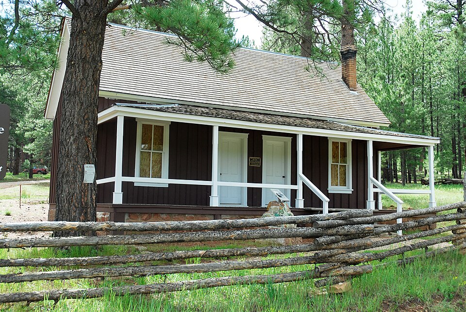
Listed on the National Register of Historic Places in 1987.
From the record
“The Jacob Lake Ranger Station is a historic U.S. Forest Service ranger station in the unincorporated community of Jacob Lake, Arizona, United States, that is listed on the National Register of Historic Places (NRHP).”
Wikipedia article Jacob Lake Ranger Station, CC BY-SA 4.0.
One of 140 National Register listings published here for Coconino County · listed in 1987 · category: Building.
National Register reference number.87001151- the number the National Park Service assigned this property when it was listed, and the key its nomination file is catalogued under at the National Archives.
Fires near this property
241 since 1992
Regional context, not property-specific
evidence. The
federal wildfire occurrence database
lists 241 fires within 5 miles of Jacob Lake Ranger Station
between 1992 and 2020, burning about 63,605 acres in total. 177 started naturally. None was recorded as arson.
Distance is straight-line from the map coordinates, so a fire counted
here may appear on a neighbouring settlement's page as well.
Reported cause
Fires
Natural
177
Recreation and ceremony
42
Missing data/not specified/undetermined
8
Equipment and vehicle use
6
Debris and open burning
5
Smoking
3
The most recent of
them, most recent first, with the day each was reported and the service
that recorded it.
Regional context, not property-specific
evidence. The federal mineral resources record lists
6 workings within 5 miles of Jacob Lake Ranger Station: 6 past producers.
None of them still produces. What was taken out: Copper, Gold, Silver, Manganese, Silver, Iron, Iron, Manganese. Distance is straight-line from the
map coordinates, so a quarry counted here may appear on a neighbouring
settlement's page as well.
Regional context, not property-specific
evidence. The National Weather Service names
Jacob Lake, the town this property stands in, in 10 storm reports between 1998 and 2025: 2 heavy rain, 2 wildfire, 2 flash flood, 1 tornado.
The reports record 2 deaths and 1 injury. Each account below is quoted exactly as the forecast office
filed it, from the NOAA Storm Events Database, and each date
opens the federal record of that event.
Lightning struck three people at LeFavre Scenic Overlook along Highway 89 about eight miles north of Jacobs Lake. Two people died and the third person sustained non-life-threatening injuries.
Forest Service officials report flooding with ash laden water through House Rock Wash along Buffalo Ranch Road (Forest Road 8910). The road was impassable and blocked access for BAER team members performing work in the area. The White Sage burn scar was upstream from this location.
The Outlet Fire began as a prescribed burn on April 25. On May 9, the fire was still within the planned enviromental conditions when it was declared a wildland fire. This was done in order to begin fire suppression efforts because of high wind predicted on May 10. High wind on May 10 forced the fire out of project bounderies about 30 miles south of Jacob Lake. This caused the closure of Highway 67 from Jacob Lake southward and the evacuation of the developed area at the North Rim of the Grand Canyon. Highway 67 to the North Rim was reopened on May 21. The fire was declaired 100% contained the evening of May 21. In all, 13,350 acers burned, over 1,200 fire personel were invovled, and nearly 35 miles of hand line were constructed around the fire. The fire fell over the canyon rim in some areas and was suppressed with aircraft where terrain was too rugged for crews to operate safely. The fire continued to burn inside fire lines long after containment. On June 4, strong wind pushed the fire off the canyon rim. This fire then burned back up onto the canyon rim and burned an additional 500 acres outside the fire lines. This part of the fire was contained again on June 5.
No historic map-sheet match is published
for this property yet. That does not mean no map exists. This record needs
a coordinate-quality review before it can be joined to a sheet boundary.
Browse the county's mapped places while that work is
pending.
Listed places nearby
4 within 8 miles
Other National Register properties close
enough to walk or drive between, ordered by distance from this one. Both
positions come from the same geocoding pass that matched these properties
to their map sheets.
Listing record. National Park Service National Register of Historic Places, listed-properties dataset, current to 2026-05-22.
Map join. Address geocoded through the United States Census geocoder, then tested against the published boundary of every sheet in the USGS Historical Topographic Map Collection.
How this page is made. Listing fields come from federal records; map-sheet coverage is a labelled coordinate-to-boundary calculation, not a source-field claim.
Wildfire. Short, Karen C. 2022. Spatial wildfire occurrence data for the United States, 1992-2020 [FPA_FOD_20221014]. 6th Edition. Fort Collins, CO: Forest Service Research Data Archive. https://doi.org/10.2737/RDS-2013-0009.6 Collected with United States Government funding and usable without additional permissions or fees.
Mines and quarries. USGS Mineral Resources Data System (MRDS) https://mrdata.usgs.gov/mrds/ A work of the United States government, no copyright under 17 U.S.C. 105.
Storms. NOAA National Centers for Environmental Information, Storm Events Database https://www.ncei.noaa.gov/stormevents/ A work of the United States government, no copyright under 17 U.S.C. 105. Narratives are quoted verbatim from the National Weather Service report and are not edited or summarised.
 Block