 Block
From the record
One of 31 National Register listings published here for Graham County · listed in 1988 · category: Building.
Sources: the case file at the National Archives · the National Register database, National Park Service
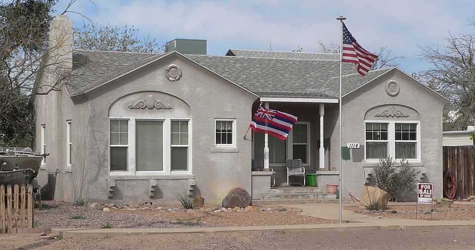
Listed on the National Register of Historic Places in 1988.
One of 31 National Register listings published here for Graham County · listed in 1988 · category: Building.
Sources: the case file at the National Archives · the National Register database, National Park Service
Regional context, not property-specific evidence. The federal wildfire occurrence database lists 18 fires within 5 miles of Hugh Talley House between 1993 and 2020, burning about 452 acres in total. None started naturally. None was recorded as arson. Distance is straight-line from the map coordinates, so a fire counted here may appear on a neighbouring settlement's page as well.
| Reported cause | Fires |
|---|---|
| Missing data/not specified/undetermined | 16 |
| Recreation and ceremony | 1 |
| Debris and open burning | 1 |
The most recent of them, most recent first, with the day each was reported and the service that recorded it.
| Date | Cause | Size | Reported by | Name on the report |
|---|---|---|---|---|
| 8 September 1998 | Missing data/not specified/undetermined | under an acre | Gila District Office | R/M |
| 6 July 2010 | Missing data/not specified/undetermined | 7.0 acres | Gila District Office | RIVER |
| 5 July 2005 | Missing data/not specified/undetermined | 24 acres | Arizona Department of Forestry and Fire Management - State Office | FIRECRACKER |
| 5 June 2005 | Missing data/not specified/undetermined | 7.0 acres | Arizona Department of Forestry and Fire Management - State Office | SATURE |
| 23 June 1998 | Missing data/not specified/undetermined | under an acre | Gila District Office | WATSON |
| 21 June 2017 | Missing data/not specified/undetermined | under an acre | Clay Springs/Pinedale Fire Department | not named |
| 20 June 2005 | Missing data/not specified/undetermined | 49 acres | Arizona Department of Forestry and Fire Management - State Office | LONE MOUNTAIN |
| 6 May 2017 | Missing data/not specified/undetermined | under an acre | Sunsites-Pearce Fire District | not named |
Regional context, not property-specific evidence. The federal mineral resources record lists 9 workings within 5 miles of Hugh Talley House: 3 past producers, 3 prospects, 2 unknowns, 1 occurrence. None of them still produces. What was taken out: Sand and Gravel, Construction, Copper, Halite, Bromine, Geothermal. Distance is straight-line from the map coordinates, so a quarry counted here may appear on a neighbouring settlement's page as well.
| Where | Site | Commodity | Status | Recorded |
|---|---|---|---|---|
| Mt Graham Well | Geothermal | Unknown | ||
| Safford Well | Halite, Bromine | Occurrence | Brine, Halite | |
| Abeyta Properties | Copper | Prospect | ||
| Cobre Claims | Copper | Prospect | ||
| Norman Property | Copper | Prospect | ||
| Gravel Pit | Sand and Gravel, Construction | Past Producer | ||
| Gravel Pit | Sand and Gravel, Construction | Unknown | ||
| Gravel Pit | Sand and Gravel, Construction | Past Producer | ||
| Morris Sand and Gravel | Sand and Gravel, Construction | Past Producer |
Regional context, not property-specific evidence. The National Weather Service names Safford, the town this property stands in, in 41 storm reports between 1995 and 2021: 20 thunderstorm wind, 14 flash flood, 4 hail, 2 flood. No death or injury is recorded in these reports. Each account below is quoted exactly as the forecast office filed it, from the NOAA Storm Events Database, and each date opens the federal record of that event.
| When | Event | Place named | Harm | What the report says |
|---|---|---|---|---|
| October 2016 | Hail | Safford | $1,500,000 | One inch diameter hail began around 2300 LST as a large thunderstorm moved through Safford. The storm eventually produced hail up to 2.5 inches in diameter. Homes, vehicles and property were damaged throughout Safford and Solomon. Copious amounts of smaller hail fell for 20 minutes in some locations, causing accumulations of up to 6. In many spots, the hail did not melt overnight and was still piled up on roads, sidewalks and yards the following morning. In addition, where hail broke windows, rain and additional hail entered buildings causing water damage. This caused some schools in Safford to remain closed for two weeks until repairs were completed. The hailstorm also wiped out around 4000 acres of cotton crop, with several million dollars of loss estimated. Graham County issued a disaster declaration in the wake of the storm. |
| October 2016 | Flash Flood | Safford | $150,000 | More than two inches of rain accompanied by large hail that piled up to six inches deep in some locations caused flash flooding in Safford. Runoff filled Freeman Wash which caused minor damage to several homes and a school, and washed out part of 12th Avenue. The flood waters temporarily displaced twenty five residents. The school was closed for two weeks until repairs were completed. Flood waters also blocked roadways in rural areas, stranding 8,000 county fair visitors until waters receded. |
| June 1997 | Thunderstorm Wind | Safford | $60,000 | A severe thunderstorm that moved through Safford knocked down 6 power poles, blew part of a roof off a house , broke off several large tree limbs, and damaged several other structures. |
| July 2009 | Thunderstorm Wind | Safford | $30,000 | A trained spotter reported many trees were downed in the central part of Safford. ASOS measured a 63 mph thunderstorm wind gust at the Safford Regional Airport.|Amateur radio operators reported numerous power poles down near Safford. |
| August 2005 | Thunderstorm Wind | Safford | $25,000 | Strong winds associated with a thunderstorm in the City of Safford, caused damage to two large observation towers, several trailers, and several vehicles as sheet metal was blown off a roof hitting the cars. |
| January 2010 | Flood | Safford | $20,000 | Graham County law enforcement performed two swift water rescues just south of Safford during the late evening hours of January 21st. Deputies responded at 10:15 PM to a truck caught in a wash on Chastain Lane, just north of Highway 366. Law enforcement rescued the motorist of the truck. There were no injuries, but the truck was fully engulfed by the water. At approximately the same time, law enforcement spotted a van stuck in Stockton Wash, along Stockton Road south of Roper Lake. The occupants of the van exited the vehicle and waded to safety, before the van was washed further down Stockton Wash. |
| July 1997 | Thunderstorm Wind | Safford | $20,000 | Thunderstorm winds blew down several power poles in Safford and the nearby towns of Thatcher and Pima. |
| August 2003 | Thunderstorm Wind | Safford | $20,000 | no account filed |
| July 2021 | Thunderstorm Wind | Safford | $15,000 | Thunderstorm winds downed several trees and power poles in the east part of Safford. |
| August 2008 | Thunderstorm Wind | Safford | $15,000 | Multiple power lines were blown down between Safford and Thatcher. |
| July 2007 | Thunderstorm Wind | Safford | $15,000 | A strong thunderstorm knocked down two power poles in Safford. |
| August 2002 | Thunderstorm Wind | Safford | $15,000 | no account filed |
| August 2004 | Flash Flood | Safford | $10,000 | Arizona Department of Transportation reported that due to flooding portions of Highway 191 had been damaged and were closed. |
| July 2008 | Thunderstorm Wind | Safford | $7,500 | A power pole was knocked down at 2nd Ave. and Thatcher St. in Safford. |
| August 2018 | Thunderstorm Wind | Safford | $7,000 | Thunderstorm winds downed a tree that fell on a house on 7th Street in Safford and downed a power pole in Thatcher. In Eden, a power line a downed tree pulled down a power line, which set a tree on fire. |
| August 2004 | Thunderstorm Wind | Safford | $5,000 | A strong thunderstorm produced wind gusts up to 61 knots (70 mph) as is moved from the northeast toward the Safford area. The first severe wind gust occurred at 1605 MST and was 53 knots (61 mph), these strong winds continued being reported by the ASOS at the Safford Airport until 1645 MST. The last severe gust reported at the airport was 52 knots (60 mph). The storms then moved into the city of Safford and downed several power poles, and one large tree by 1648 MST. |
| October 2000 | Flood | Safford | $5,000 | Road closures due to flooding on Sally Bryce Road in Tally wash area. Heavy rain damaged cotton crops and pinto bean fields. |
| August 2007 | Thunderstorm Wind | Safford | $3,000 | A cinder block wall was knocked down at a residence in Safford due to strong winds. In addition, debris covered much of Highway 191 from just south of Safford to near Artesia. |
| October 2015 | Thunderstorm Wind | Safford | $2,000 | A power pole was snapped off at the base. In another area, power lines were snapped and were dangling from their poles. |
| July 2013 | Thunderstorm Wind | Safford | $1,000 | Thunderstorm winds picked up a storage container and blew it into a gas main. |
| April 2004 | Thunderstorm Wind | Safford | $1,000 | An isolated thunderstorm moving east produced a 56 mph wind gust and knocked down a power pole in Safford. Also the Safford Agricultural Station reported wind gusts up to 57 mph. |
| August 2004 | Thunderstorm Wind | Safford | $1,000 | Power lines were downed by strong winds. |
| July 2002 | Thunderstorm Wind | Safford | $500 | no account filed |
| September 2021 | Flash Flood | Safford | - | Nearly 1.5 of rain in about 30 minutes caused flash flooding of streets in Safford. |
| August 2018 | Flash Flood | Safford | - | Heavy rain of 1.5 to 2.5 inches caused Peterson Wash to overflow Safford Bryce Road, north of the Gila River in Safford. |
| July 2015 | Tornado (EF0) | Safford | - | A dust devil was stretched into a small landspout tornado by a passing thunderstorm near Safford. No damage was reported. |
| August 2008 | Flash Flood | Safford | - | A trained spotter reported 1.5 feet of water flowing over Cholla Street. |
| July 2007 | Flash Flood | Safford | - | Flooding and debris occurred along 8th street in Safford due to Flash Flooding. In addition, Klondyke Wash west of Safford was impassible. |
| July 2007 | Flash Flood | Safford | - | Low water crossings were flooded at Watson Canal, Kelley Canal and north of the Gila River/Pima Bridge. |
| July 2006 | Thunderstorm Wind | Safford | - | The ASOS (automated surface observing system) at the Safford International Airport recorded a severe thunderstorm wind gust of 56 knots (64 mph). |
| August 2006 | Flash Flood | Safford | - | Heavy rainfall over Mount Graham, just southwest of the City of Safford, caused roadway flooding along Highway 366. The Arizona Department of Transportation reported water, rocks and debris over the highway at mile post 121 (Noon Creek) and again at mile post 123 (Wet Canyon). |
| August 2005 | Flash Flood | Safford | - | Heavy rain over Mount Graham caused flooding and closure of several roads including: Aravapia Road, Bookerson Road, and Ash Creek Road. |
| August 2005 | Flash Flood | Safford | - | Noon Creek overtopped Highway 366, the road was reported to be impassable due to flood waters and was closed. Also a rockslide was reported at the intersection of Noon Creek and Highway 366. |
| August 2004 | Flash Flood | Safford | - | Significant rainfall on the Nuttal burn area caused Noon Creek to flood and overtop highway 366. Debris and large logs blocked the road making it impassable. |
| August 2004 | Hail | Safford | - | About 106 pounds of cotton crops were damaged by hail near Safford. These 106 pounds were reported to be worth about 4000 dollars. |
| August 2004 | Flash Flood | Safford | - | Significant rainfall on the Nuttall burn area caused Noon Creek to flood and overtop highway 366. Large logs and debris covered the road causing it to be impassable. |
| September 2004 | Hail | Safford | - | Significant hail damage was reported in the Safford area. The hail fell for about 30 minutes and stripped apples off of trees in a local orchard. |
| August 1997 | Flash Flood | Safford | - | Flooding was reported across state highway 191. |
| August 1995 | Thunderstorm Wind | Safford | - | Power lines knocked down. |
| September 2021 | Hail | Safford | - | no account filed |
| September 2003 | Flash Flood | Safford | - | no account filed |
2 papers published in this town, digitised by the Library of Congress and free to read: 1,314 issues, 5,632 pages. Every page is searchable, so a name or a street can be looked for directly in what the town printed about itself at the time.
| Newspaper | Published |
|---|---|
| Safford Rattler | 1896 to 189? |
| Graham Guardian | 1895 to 1923 |
No historic map-sheet match is published for this property yet. That does not mean no map exists. This record needs a coordinate-quality review before it can be joined to a sheet boundary. Browse the county's mapped places while that work is pending.
Other National Register properties close enough to walk or drive between, ordered by distance from this one. Both positions come from the same geocoding pass that matched these properties to their map sheets.
| Photograph | Property | Distance | Listed |
|---|---|---|---|
 | James R. Welker House | under 500 feet | 1988 |
 | Alonzo Hamilton Packer House | under 500 feet | 1988 |
 | William Charles Davis House | under 500 feet | 1988 |
 | William Talley House | under 500 feet | 1988 |
 | George A. Olney House | 0.1 miles | 1988 |
 | David Wickersham House | 0.1 miles | 1988 |
| National Archives record | The nomination case file for reference 87002580 in Record Group 79. |
| Graham County | All 31 listed properties in this county. |