 Block
From the record
One of 467 National Register listings published here for Maricopa County · listed in 1988 · category: Structure.
Sources: the case file at the National Archives · the National Register database, National Park Service
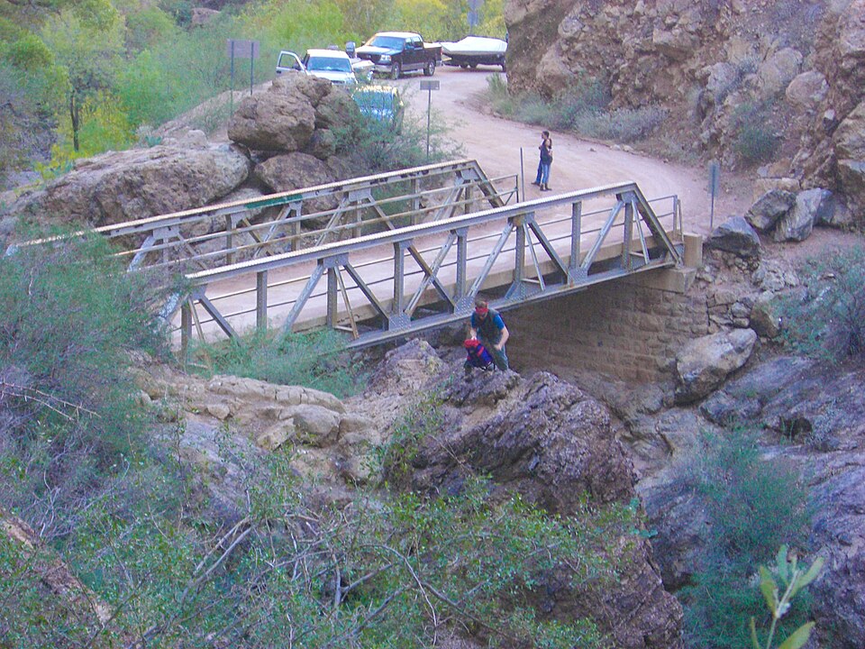
Listed on the National Register of Historic Places in 1988.
One of 467 National Register listings published here for Maricopa County · listed in 1988 · category: Structure.
Sources: the case file at the National Archives · the National Register database, National Park Service
Regional context, not property-specific evidence. The federal wildfire occurrence database lists 74 fires within 5 miles of Fish Creek Bridge between 1992 and 2020, burning about 2,485 acres in total. 25 started naturally. 4 were recorded as arson. Distance is straight-line from the map coordinates, so a fire counted here may appear on a neighbouring settlement's page as well.
| Reported cause | Fires |
|---|---|
| Natural | 25 |
| Missing data/not specified/undetermined | 24 |
| Equipment and vehicle use | 9 |
| Recreation and ceremony | 6 |
| Arson/incendiarism | 4 |
| Smoking | 2 |
| Fireworks | 2 |
| Debris and open burning | 1 |
| Power generation/transmission/distribution | 1 |
The most recent of them, most recent first, with the day each was reported and the service that recorded it.
| Date | Cause | Size | Reported by | Name on the report |
|---|---|---|---|---|
| 5 September 2004 | Missing data/not specified/undetermined | under an acre | Tonto National Forest | CORONADO |
| 6 August 2010 | Fireworks | 2.0 acres | Tonto National Forest | FISH |
| 28 August 1994 | Natural | under an acre | Tonto National Forest | not named |
| 27 August 1994 | Natural | 300 acres | Tonto National Forest | BRONCO |
| 26 August 1995 | Natural | under an acre | Tonto National Forest | CRAB |
| 25 August 2010 | Equipment and vehicle use | under an acre | Tonto National Forest | FISH CREEK |
| 24 August 2000 | Natural | 12 acres | Tonto National Forest | TORTILLA |
| 23 August 1995 | Natural | 3.0 acres | Tonto National Forest | GOAT |
Regional context, not property-specific evidence. The federal mineral resources record lists 1 working within 5 miles of Fish Creek Bridge: 1 occurrence. None of them still produces. What was taken out: Copper, Tungsten, Lead, Zinc. Distance is straight-line from the map coordinates, so a quarry counted here may appear on a neighbouring settlement's page as well.
| Where | Site | Commodity | Status | Recorded |
|---|---|---|---|---|
| Whetrocks, Elephant Co Copper - Tungsten | Copper, Tungsten, Lead, Zinc | Occurrence | Chrysocolla, Malachite |
Regional context, not property-specific evidence. The National Weather Service names Tortilla Flat, the town this property stands in, in 26 storm reports between 1997 and 2025: 15 flash flood, 8 thunderstorm wind, 1 heavy rain, 1 flood. The reports record 3 deaths and 3 injuries. Each account below is quoted exactly as the forecast office filed it, from the NOAA Storm Events Database, and each date opens the federal record of that event.
| When | Event | Place named | Harm | What the report says |
|---|---|---|---|---|
| August 2020 | Flash Flood | Tortilla Flat | 2 killed, 3 hurt, $10,000 | A strong thunderstorm produced heavy rain over southern portions of the Bush Fire burn scar during the evening of the 22nd. Heavy rainfall associated with the thunderstorm led to an estimated 1-2 of rain within 20-30 minutes over the headwaters of the Alder Creek basin, resulting in a flash flood with debris coming down Alder Creek. A group of people camping at the foot of Alder Creek on the north shore of Apache Lake attempted to flee the area by boat as the flash flood approached. The flash flood with debris caused an inoperable boat carrying five adults to capsize. Three out of the five adults were rescued out of the water by another boat. The other two adults, a 41 year old female and a 52 year old male, died as a result of drowning and were recovered by Maricopa County Sheriff's Office. Collaboration between the National Weather Service, Arizona Geological Survey, and Maricopa County Flood Control District determined that this event was not a debris flow. |
| August 2024 | Thunderstorm Wind | Tortilla Flat | 1 killed | An adult male was found deceased due to drowning at Canyon Lake. The man was paddle boarding at the time the thunderstorm was approaching and fell off the paddleboard likely due to the strong winds and higher waves. A surface observing site located at Canyon Lake measured a peak gust of 40 mph. |
| September 2019 | Flash Flood | Tortilla Flat | $40,000 | Copious amounts of tropical moisture spread northward and into south-central Arizona during the early morning hours on September 23rd, leading to the development of numerous showers and thunderstorms over higher terrain areas east of Phoenix. Locally heavy rain developed, with peak rain rates in excess of 2 inches per hour. By mid morning, a number of locations had already received more than 3 inches of rain. The heavy rain led to episodes of flash flooding from Tortilla Flat eastward. At 0605MST, the Fish Creek USGS stream gage 5 miles east of Tortilla Flat reported an increase from 5 feet to 9.5 feet. At 0615MST, Arizona Department of Highways reported that State Route 88 was closed indefinitely between Tortilla Flat and State Route 188. The closure was due to flash flooding as well as debris across the road. Additionally, at 0748MST a member of the public reported flash flooding along Lewis and Pranty Creek near State Route 88. This occurred roughly 7 miles east of Tortilla Flat and south of Apache Lake. The report also indicated that water had jumped out of the creek's banks and was inundating one of the properties in the area. Multiple Flash Flood Warnings were issued during the morning and were in effect at the time of the flooding. No injuries were reported fortunately. |
| August 2013 | Thunderstorm Wind | Tortilla Flat | $40,000 | Scattered afternoon thunderstorms developed on August 26th and they affected the Salt River Recreational Lakes, including the community of Tortilla Flats. The atmosphere was moist and very unstable, and this allowed the thunderstorms to produce strong and damaging wind gusts. According to a report received from the public, a dock and 2 boats were damaged at the Canyon Lake Marina. They estimated peak wind gusts to be around 60 mph. A Severe Thunderstorm Warning had been issued for the area around Tortilla Flats, beginning at 1553MST and continuing until 1615MST. |
| November 2019 | Flash Flood | Tortilla Flat | $25,000 | Deep moisture, some of it tropical in nature, interacted with a pair of low pressure systems to produce widespread moderate to heavy rain across the high terrain east of Phoenix during evening hours on November 20th. The heavy rain resulted in episodes of flash flooding that impacted the Woodbury burn scar area. According to a report from the public, at 1930MST flash flooding resulted in a rise of 15 feet along upper Campaign Creek, about 10 miles to the southeast of the town of Roosevelt. The heavy flow washed away an out-building in the area. There were no reports of injuries due to the flash flooding, fortunately. |
| August 2021 | Flash Flood | Tortilla Flat | $15,000 | The unpaved portion of State Route 88/Apache Trail was closed between NF-79 (mile post 230) and NF-51 (mile post 242) due to significant flash flooding and the road being washed out in many places. Arizona Department of Transportation reported the closure on the 19th, but the flooding impacts occurred on the 18th. According to Apache Lake Marina & Resort, some customers and employees had to be evacuated out of the area. Videos on social media show some of the road damage and washouts. The nearest rain gage at Reavis Trailhead measured 1.61 inches between 1350MST and 1550MST and radar estimates were upwards of 2 inches. Runoff on the southern end of the closure may have been enhanced by the 2019 Woodbury Fire burn area. Timing based on the rain gage and radar. No injuries were reported. |
| August 2021 | Flash Flood | Tortilla Flat | $10,000 | Dirt road up to Reevis Mountain School, which cuts through Campaign Creek, was washed out by significant flash flooding. A couple yurpees on the property of the school were damaged or destroyed. Their fire circle and labyrinth were also washed away. The school and road are inside the 2019 Woodbury burn area. Rainfall of 4.5 inches was measured in 3 to 4 hours. Timing based on radar. No injuries were reported. |
| November 2019 | Flash Flood | Tortilla Flat | $5,000 | Deep moisture, some of it tropical in nature, interacted with a pair of low pressure systems to produce locally heavy rain across the high terrain east of Phoenix during the evening hours on November 20th. The heavy rain resulted in episodes of flash flooding that impacted the Woodbury burn scar and areas near the scar. At about 2000MST, a public report was received that described a rapid rise of water and out of the bank flooding along Lewis and Pranty Creek below the Woodbury fire's burn scar. A bit later, at 2025MST, a mesonet gage on Fish Creek located 5 miles east of Tortilla Flat reported a rapid rise of over 4 feet. The USGS stream gage was located below the Woodbury fire burn scar. Fortunately there were no reports of injuries due to the flash flooding. |
| August 2019 | Flash Flood | Tortilla Flat | $2,000 | Scattered monsoon thunderstorms developed during the afternoon across higher terrain locations east of Phoenix, and east of Apache Junction. Some of the storms produced locally heavy rains with peak rain rates in excess of one inch per hour. The heavy rain led to an episode of flash flooding across the Woodbury burn scar. At 1400MST, there was a report from the public of a high water flow event within Campaign Creek; the heavy flow originated within the burn scar. The flash flooding impacted several low water crossings along J-B Road. One inch of water was measured at the Reevis Mountain School, located within the burn scar. There were no reports of accidents or injuries fortunately. A Flash Flood Warning was in effect at the time of the flooding. |
| September 2023 | Flash Flood | Tortilla Flat | $1,000 | State Route 88 between mileposts 229 and 242 southwest of Roosevelt Lake was closed due to flooding and rockslides, making the road impassable. No injuries were reported. |
| August 2025 | Thunderstorm Wind | Tortilla Flat | - | A 68 mph peak gust was measured at a mesonet site in Tortilla Flat. |
| February 2023 | Thunderstorm Wind | Tortilla Flat | - | A mesonet station located near Tortilla Flat measured a wind gust of 72 mph as a line of showers and storms quickly moved eastward through the foothills north and east of Phoenix. |
| July 2022 | Flash Flood | Tortilla Flat | - | The Arizona Department of Transportation reported SR 88 was closed due to flooding between milepost 201 and 205. No damages or injuries were reported. |
| October 2021 | Thunderstorm Wind | Tortilla Flat | - | Mesonet station SRP45 measured a 73 mph wind gust. |
| October 2021 | Flash Flood | Tortilla Flat | - | Social media video showed swift-moving water within Weekes Wash and flowing across State Route 88 near 1st Water Road, making the road impassable. Timing approximated. No damages or injuries were reported. |
| August 2021 | Flash Flood | Tortilla Flat | - | Arizona Department of Transportation reported State Route 88 was closed in both directions between mile posts 229 and 242 due to flooding. Timing estimated based on radar. No damages or injuries were reported. |
| July 2021 | Flash Flood | Tortilla Flat | - | Upper Campaign Creek rose 1 to 2 feet. Runoff may have been enhanced by the 2019 Woodbury burn scar. Low water crossing along J Bar Road closed due to flowing water and debris. Time estimated from radar and nearby NWS rain gage. No damage or injuries were reported. |
| August 2021 | Hail | Tortilla Flat | - | Estimated pea-sized hail fell for approximately one hour and caused significant crop damage around the property of Reevis Mountain School. Most of the fruit trees were affected, with the peach and jujube harvests deemed total losses. Nearly an acre of vegetable leaves were shredded. Many of the walnuts and all pecans fell off their trees. Damage costs were not provided. |
| June 2021 | Thunderstorm Wind | Tortilla Flat | - | Isolated thunderstorms developed over the higher terrain east of Phoenix during the afternoon of the 30th. One of these thunderstorms developed near Roosevelt Lake and quickly became strong. At 15:45 MST, an SRP mesonet station at Roosevelt Dam measured a wind gust of 59 mph. No damage or injuries were reported with this thunderstorm. |
| August 2021 | Flash Flood | Tortilla Flat | - | Arizona Department of Transportation closed State Route 88 between mile posts 230 and 242 due to flooding. Timing of impacts based on radar. No damages or injuries were reported. |
| February 2019 | Flood | Tortilla Flat | - | A powerful winter storm continued to slowly move east across Arizona during the day on February 22nd, and moderate to locally heavy rain fell across portions of south-central Arizona including in the areas around Tortilla Flat. The rain led to episodes of small stream flooding; at 1240MST the Arizona Department of Highways reported that State Route 88 was closed at Tortilla Flat due to flooding; the flooding resulted from water from a creek overflowing the road making it impassable. Although Areal Flood Warnings were issued earlier in the day, they were not in effect at the time of the flooding in Tortilla Flat. No accidents or injuries were reported. |
| September 2019 | Flash Flood | Tortilla Flat | - | Isolated to scattered monsoon thunderstorms developed across the higher terrain east of Phoenix during the evening hours on September 7th. Some of the stronger storms produced locally heavy rains with peak rain rates well in excess of one inch per hour. A trained spotter in Globe measured just over one half inch of rain within 20 minutes shortly after 2100MST. The heavy rain resulted in an episode of flash flooding near the town of Tortilla Flat. At 2215MST a mesonet gage 5 miles east of the town reported a rapid rise in water in Fish Creek Canyon. The water rapidly rose nearly 2 feet as reported by the USGS gage for Fish Creek. A Flash Flood Warning was issued well in advance of the flooding, for areas just to the east of the gage's location. No injuries were reported as a result of the quickly moving flood waters. |
| November 2019 | Flash Flood | Tortilla Flat | - | A powerful Pacific low pressure system moving slowly east across Arizona interacted with deep moisture to produce widespread moderate to heavy rain across higher terrain areas east of Phoenix during the morning hours on November 29th. In addition to influence from frontal lift, isolated thunderstorms helped locally increase rain totals. The heavy rain resulted in some flash flooding that occurred around the Woodbury burn scar area. Based on data from a USGS stream gage, heavy rain on the burn scar caused a rapid rise of nearly 4 feet in Fish Creek Canyon, about 5 miles east of the town of Tortilla Flat. The most significant flash flooding occurred around 0815MST. There were no reports of accidents due to the flash flooding. A Flash Flood Warning was in effect at the time of the flooding. |
| August 2015 | Thunderstorm Wind | Tortilla Flat | - | Thunderstorms developed across southern Gila County during the afternoon hours on August 27th, and the stronger ones produced strong and gusty outflow winds. At 1430MST a mesonet weather station at the Roosevelt Dam measured a wind gust to 58 mph. |
| September 2010 | Heavy Rain | Tortilla Flat | - | A local utility company reported that 3.5 inches of rain fell at Horse Mesa Dam by Apache Lake. The rain was a storm total, ending at 6 am. The heavy rain led to the issuance of a flash flood warning over northeastern Maricopa County. |
| September 1997 | Thunderstorm Wind | Tortilla Flat | - | The Canyon Lake Marina was relocated 50 feet due to thunderstorm winds estimated near 80 mph. Numerous boats, 360 in all, shifted 50 feet east or north. During the strong winds, the relocated marina and several of the boats sustained damage. |
No historic map-sheet match is published for this property yet. That does not mean no map exists. This record needs a coordinate-quality review before it can be joined to a sheet boundary. Browse the county's mapped places while that work is pending.
Other National Register properties close enough to walk or drive between, ordered by distance from this one. Both positions come from the same geocoding pass that matched these properties to their map sheets.
| Photograph | Property | Distance | Listed |
|---|---|---|---|
| Lewis and Pranty Creek Bridge | 1.0 miles | 1988 | |
 | Horse Mesa Dam | 4.6 miles | 2017 |
| Pine Creek Bridge | 6.9 miles | 1988 | |
 | Boulder Creek Bridge | 7.3 miles | 1989 |
| National Archives record | The nomination case file for reference 88001600 in Record Group 79. |
| Maricopa County | All 467 listed properties in this county. |