 Block
From the record
One of 100 National Register listings published here for Pinal County · listed in 1988 · category: Structure.
Sources: the case file at the National Archives · the National Register database, National Park Service
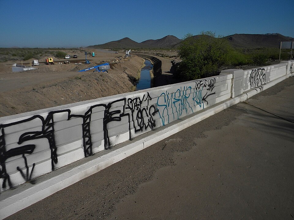
Listed on the National Register of Historic Places in 1988.
One of 100 National Register listings published here for Pinal County · listed in 1988 · category: Structure.
Sources: the case file at the National Archives · the National Register database, National Park Service
Regional context, not property-specific evidence. The federal wildfire occurrence database lists 1,036 fires within 5 miles of San Tan Canal Bridge between 1992 and 2020, burning about 3,945 acres in total. 1 started naturally. 103 were recorded as arson. Distance is straight-line from the map coordinates, so a fire counted here may appear on a neighbouring settlement's page as well.
| Reported cause | Fires |
|---|---|
| Missing data/not specified/undetermined | 655 |
| Debris and open burning | 219 |
| Arson/incendiarism | 103 |
| Misuse of fire by a minor | 29 |
| Equipment and vehicle use | 14 |
| Fireworks | 4 |
| Smoking | 3 |
| Other causes | 3 |
| Recreation and ceremony | 3 |
| Power generation/transmission/distribution | 1 |
| Natural | 1 |
| Firearms and explosives use | 1 |
The most recent of them, most recent first, with the day each was reported and the service that recorded it.
| Date | Cause | Size | Reported by | Name on the report |
|---|---|---|---|---|
| 9 September 2020 | Missing data/not specified/undetermined | under an acre | Pima Agency | GRANDE |
| 9 September 2001 | Missing data/not specified/undetermined | under an acre | Arizona Department of Forestry and Fire Management - State Office | CONLEY |
| 9 September 1997 | Equipment and vehicle use | under an acre | Pima Agency | HOTDOG |
| 9 September 1993 | Debris and open burning | 20 acres | Pima Agency | BLUE BIRD |
| 8 September 1996 | Missing data/not specified/undetermined | under an acre | Pima Agency | FOUR LAW |
| 6 September 1992 | Missing data/not specified/undetermined | 10 acres | Pima Agency | GARCIA |
| 5 September 2008 | Equipment and vehicle use | under an acre | Pima Agency | W. PIMA |
| 5 September 1993 | Debris and open burning | under an acre | Pima Agency | #7SEEDFARM |
Regional context, not property-specific evidence. The federal mineral resources record lists 12 workings within 5 miles of San Tan Canal Bridge: 8 past producers, 3 prospects, 1 occurrence. None of them still produces. What was taken out: Sand and Gravel, Construction, Stone, Crushed/Broken, Copper, Stone. Distance is straight-line from the map coordinates, so a quarry counted here may appear on a neighbouring settlement's page as well.
| Where | Site | Commodity | Status | Recorded |
|---|---|---|---|---|
| Apache Maid Group | Copper, Gold | Prospect | ||
| Stone Quarry | Stone | Past Producer | ||
| Wedge Group | Gold, Copper | Prospect | ||
| Blackwater Copper | Copper | Past Producer | ||
| Mineral Butte Group Block Ii | Copper | Prospect | ||
| North Bank - Gila River | Stone, Crushed/Broken | Occurrence | Sedimentary | |
| Olberg | Stone, Crushed/Broken | Past Producer | Basalt, Granite | |
| Borrow Pit | Sand and Gravel, Construction | Past Producer | ||
| Gravel Pit | Sand and Gravel, Construction | Past Producer | ||
| Gravel Pit | Sand and Gravel, Construction | Past Producer |
Regional context, not property-specific evidence. The National Weather Service names Sacaton, the town this property stands in, in 10 storm reports between 2002 and 2022: 7 thunderstorm wind, 3 flash flood. No death or injury is recorded in these reports. Each account below is quoted exactly as the forecast office filed it, from the NOAA Storm Events Database, and each date opens the federal record of that event.
| When | Event | Place named | Harm | What the report says |
|---|---|---|---|---|
| July 2002 | Thunderstorm Wind | Sacaton | $500,000 | Damage from strong winds extended over a large area of north central and northwest Pinal County. Trees were uprooted in Coolidge and homes were damaged in Florence. Winds were clocked at 55 mph on an automatic weather station 20 miles south of Queen Creek. A spotter reported two roofs ripped off maintenance buildings at the Sacaton Middle School, where winds were estimated as high as 80 mph. Another spotter driving along I-10 near Casa Grande reported freeway signs blown down as dense blowing dust hit the area. A power pole was also blown down across McCartney Road just south of Casa Grande. Eight mature trees were uprooted at the Central Arizona College with power and telephone outages lasting into Wednesday morning. |
| July 2011 | Thunderstorm Wind | Sacaton | $150,000 | According to a local storm chaser, strong thunderstorm microburst winds estimated to be in excess of 50 knots knocked down 20 power poles approximately 4 miles west of Sacaton. |
| July 2011 | Thunderstorm Wind | Sacaton | $25,000 | Strong thunderstorms with damaging microburst winds affected the community of Sacaton during the evening hours on July 5th. According to Pinal county Emergency Managers, gusty winds estimated to be around 65 knots uprooted two twenty inch trees. The two trees then fell on the police station located at the Gila River indian community. No injuries were reported. |
| July 2017 | Flash Flood | Sacaton | $20,000 | Thunderstorms with locally heavy rainfall developed across much of the greater Phoenix area during the morning hours on July 24th, and with peak rain rates reaching 2 inches per hour at times, episodes of flash flooding developed as a result. One of the communities affected by flash flooding was the town of Sacaton, to the southeast of Phoenix. According to a report from the public, at 0900MST flash flooding occurred about 3 miles southeast of Sacaton; flood waters partially submerged a truck and they also washed away a number of palm trees located roughly at Sacaton and highway 87. A Flash Flood Warning was in effect at the time, but it was slightly north of the location of the flash flooding, over portions of Apache Junction and Queen Creek. |
| July 2019 | Thunderstorm Wind | Sacaton | $8,000 | Isolated to scattered thunderstorms developed across portions of the greater Phoenix area, including area to the southeast of Phoenix, during the afternoon hours on July 30th. Some of the stronger storms generated powerful outflow winds estimated to be in excess of 60 mph. According to a trained weather spotter located 1 miles south of the town of Sacaton, outflow winds estimated at least as high as 65 mph knocked over small trees near Ocotillo Road and See Farm Road. Limbs were torn off of other trees, and metal sheeting was blown off of some carport roofs in the area. No injuries were reported due to the damage. |
| July 2007 | Thunderstorm Wind | Sacaton | $5,000 | Winds gusted to 60 mph and blew down several power lines. |
| October 2022 | Flash Flood | Sacaton | - | Flooding reported in the area of SR-387 and SR-187 in Sacaton. No damages or injuries were reported. |
| July 2017 | Flash Flood | Sacaton | - | Thunderstorms with heavy rain developed across much of the eastern and southeastern portions of the greater Phoenix area during the evening hours on July 23rd. The heavy rain led to episodes of urban flooding as well as flash flooding, affecting communities such as San Tan Valley and Queen Creek. At 1905MST, a trained spotter 9 miles southeast of Queen Creek measured 0.88 inches of rain within 30 minutes along the Hunt Highway in San Tan Valley. This intense rainfall led to flash flooding; at about the same time another trained spotter 5 miles southeast of Queen Creek reported that very heavy rains caused low water crossings in San Tan Valley to become flooded. Additionally, at 2002MST another trained spotter 7 miles southeast of Queen Creek measured nearly 1.5 inches of rain in one hour, further illustrating the intense nature of the evening rainfall. He also reported flash flooding at 2043MST, at the intersection of West Judd Road and North Brenner Pass Road. As of 2039MST, public reports indicated that parts of Empire Road and Riggs Road were closed due to the flash flooding. Fortunately, no injuries were reported due to the flash flooding. |
| October 2010 | Thunderstorm Wind | Sacaton | - | A trained spotter near Sacaton reported a thunderstorm wind gust estimated at 52 knots. No damage was reported with this strong wind. |
| October 2005 | Thunderstorm Wind | Sacaton | - | Truck blown off road. |
No historic map-sheet match is published for this property yet. That does not mean no map exists. This record needs a coordinate-quality review before it can be joined to a sheet boundary. Browse the county's mapped places while that work is pending.
Other National Register properties close enough to walk or drive between, ordered by distance from this one. Both positions come from the same geocoding pass that matched these properties to their map sheets.
| Photograph | Property | Distance | Listed |
|---|---|---|---|
 | Sacaton Dam Bridge | 0.2 miles | 1988 |
 | C. H. Cook Memorial Church | 3.3 miles | 1975 |
| National Archives record | The nomination case file for reference 88001622 in Record Group 79. |
| Pinal County | All 100 listed properties in this county. |