 Block
From the record
One of 43 National Register listings published here for Gila County · listed in 1989 · category: Site.
Sources: the case file at the National Archives · the National Register database, National Park Service
Listed on the National Register of Historic Places in 1989.
One of 43 National Register listings published here for Gila County · listed in 1989 · category: Site.
Sources: the case file at the National Archives · the National Register database, National Park Service
Regional context, not property-specific evidence. The federal wildfire occurrence database lists 111 fires within 5 miles of Tonto National Monument, Lower Ruin (AZ U:8:047A ASM) between 1992 and 2020, burning about 1,288 acres in total. 34 started naturally. 1 was recorded as arson. Distance is straight-line from the map coordinates, so a fire counted here may appear on a neighbouring settlement's page as well.
| Reported cause | Fires |
|---|---|
| Natural | 34 |
| Missing data/not specified/undetermined | 30 |
| Equipment and vehicle use | 18 |
| Recreation and ceremony | 16 |
| Smoking | 5 |
| Misuse of fire by a minor | 3 |
| Fireworks | 2 |
| Arson/incendiarism | 1 |
| Power generation/transmission/distribution | 1 |
| Debris and open burning | 1 |
The most recent of them, most recent first, with the day each was reported and the service that recorded it.
| Date | Cause | Size | Reported by | Name on the report |
|---|---|---|---|---|
| 8 September 2017 | Natural | 231 acres | Tonto National Forest | YELLOW JACKET |
| 4 September 2013 | Natural | 173 acres | Tonto National Forest | PINION |
| 11 September 1995 | Missing data/not specified/undetermined | under an acre | Tonto National Monument | NATIONAL |
| 11 September 1995 | Missing data/not specified/undetermined | under an acre | Tonto National Forest | NATIONAL |
| 9 August 1993 | Natural | 23 acres | Tonto National Forest | not named |
| 8 August 1997 | Natural | under an acre | Tonto National Forest | GEPHART |
| 8 August 1995 | Natural | under an acre | Tonto National Forest | ALCHESAY |
| 7 August 1998 | Natural | 2.0 acres | Tonto National Forest | SALOME |
Regional context, not property-specific evidence. The federal mineral resources record lists 5 workings within 5 miles of Tonto National Monument, Lower Ruin (AZ U:8:047A ASM): 2 past producers, 2 unknowns, 1 occurrence. None of them still produces. What was taken out: Sand and Gravel, Construction, Gold, Thorium. Distance is straight-line from the map coordinates, so a quarry counted here may appear on a neighbouring settlement's page as well.
| Where | Site | Commodity | Status | Recorded |
|---|---|---|---|---|
| Christmas Gift M S 4587 | Gold | Past Producer | ||
| Ida A Claims | Thorium | Occurrence | Monazite | |
| Gravel Pit | Sand and Gravel, Construction | Unknown | ||
| Gravel Pit | Sand and Gravel, Construction | Unknown | ||
| Gravel Pit | Sand and Gravel, Construction | Past Producer |
Regional context, not property-specific evidence. The National Weather Service names Roosevelt, the town this property stands in, in 33 storm reports between 1996 and 2021: 10 thunderstorm wind, 7 heavy rain, 6 hail, 6 flash flood. The reports record 2 injuries. Each account below is quoted exactly as the forecast office filed it, from the NOAA Storm Events Database, and each date opens the federal record of that event.
| When | Event | Place named | Harm | What the report says |
|---|---|---|---|---|
| July 2003 | Lightning | Roosevelt | 1 hurt | A thirty-seven year old man was struck by lightning near his boat at Lake Roosevelt. |
| July 1999 | Lightning | Roosevelt | 1 hurt | Man suffered minor injuries from a lightning bolt. |
| June 2015 | Thunderstorm Wind | Roosevelt | $50,000 | Strengthening southeasterly monsoonal flow imported increasing moisture into southern Gila County and as a result isolated to scatted thunderstorms developed during the late afternoon hours. Some of the storms generated strong and gusty outflow winds which affected Roosevelt Lake. Wind gusts estimated to be nearly 70 mph created 3 to 4 foot swells along the southern periphery of Roosevelt Lake, about 2 miles east of the town of Roosevelt. According to the Tonto Basin Fire Department and Rescue, the large swells knocked a number of boats into the shore and numerous people were knocked into the water as a result. The Tonto Basin Fire Department then performed multiple rescues of the affected people. |
| August 2013 | Thunderstorm Wind | Roosevelt | $20,000 | Thunderstorms developed across portions of southern Gila county during the afternoon hours on August 17th, and they affected the community of Roosevelt. The storms generated gusty and damaging winds. A trained weather spotter in Roosevelt estimated a wind gust to 60 mph. He also reported additional storm damage to the Roosevelt Lakeview Park Mobile Home RV Park. The strong winds, estimated to be at least 60 mph, tore up awnings and broke windows at some of the properties at the RV park. A Severe Thunderstorm Warning was in effect for the Roosevelt area at the time; it was issued at 1703MST and ran until 1800MST. |
| June 2015 | Thunderstorm Wind | Roosevelt | $8,000 | Strengthening southeasterly monsoonal flow imported increasing moisture into southern Gila County, and led to the development of strong thunderstorms during the late afternoon hours on June 27th. The stronger storms produced gusty and damaging outflow winds, estimated to reach as high as 70 mph. According to a trained weather spotter in the town of Roosevelt, gusty winds uprooted a large pine tree and blew it against a house. This occurred at approximately 1750MST. |
| December 2010 | Thunderstorm Wind | Roosevelt | $2,000 | A billboard along State Highway 188 across from Spring Creek Store was damaged and a nearby tree was uprooted. In addition, part of a rooftop cooler was blown down. Finally, a member of the public reported a measured wind gust to 59 mph at 435 am in Tonto Village. This person also indicated that 1.84 inches of storm total precipitation was observed. |
| September 2009 | Lightning | Roosevelt | $2,000 | Lake patrol at Roosevelt Lake reported a lightning strike that caused a brief power outage at the marina. A small shed was also damaged. |
| October 2021 | Thunderstorm Wind | Roosevelt | - | Mesonet station AU919 (2 SSE Roosevelt) measured a 63 mph wind gust. |
| July 2021 | Thunderstorm Wind | Roosevelt | - | Mesonet station AU919 at 2 miles SSE of Roosevelt measured a 63 mph wind gust. |
| July 2016 | Thunderstorm Wind | Roosevelt | - | Strong thunderstorms moved across the higher terrain of southern Gila County during the early evening hours on July 29th. Some of the storms produced gusty outflow winds measured to be at least as high as 60 mph. At 1843MST, a mesonet weather station 2 miles southeast of the town of Roosevelt measured a gust at 60 mph. |
| June 2015 | Thunderstorm Wind | Roosevelt | - | Strengthening southeasterly monsoonal flow imported increasing moisture into southern Gila County and as a result isolated to scattered thunderstorms developed during the late afternoon hours. Some of the storms produced strong and gusty winds. At 1800MST the Roosevelt Lake RAWS station measured a peak wind gust to 72 mph. Earlier, at 1720MST, a trained spotter 3 miles southeast of Roosevelt Lake measured a thunderstorm wind gust to 60 mph. |
| July 2010 | Flash Flood | Roosevelt | - | Washes and low-lying areas became flooded after 0.70 inches fell in about an hour. |
| July 2010 | Heavy Rain | Roosevelt | - | Heavy downpours from slow moving thunderstorms resulted in .80 inch in about an hour. |
| September 2009 | Heavy Rain | Roosevelt | - | Heavy rain with thunderstorms struck Roosevelt late in the afternoon. One report included 1.47 inches in just 48 minutes at Roosevelt dam. |
| July 2008 | Heavy Rain | Roosevelt | - | Pinto Creek at highway 188 was reported to be filled, and Campaign Creek broke through a small berm at Roosevelt Lake Estates. One spotter at Roosevelt Resort had 1.5 to 2 inches of rain. |
| July 2008 | Hail | Roosevelt | - | Hail about the size of pennies was reported at Roosevelt Estates. |
| September 2007 | Flash Flood | Roosevelt | - | Flash flooding reported in Roosevelt Estates. Campaign creek had one to two feet of water approximately 60 feet wide that flowed across Mesquite Street. |
| July 2007 | Flash Flood | Roosevelt | - | Flooding was reported by a COOP observer in Roosevelt. |
| July 2006 | Heavy Rain | Roosevelt | - | Observer at Roosevelt reported .88 inches in just 30 minutes. Spotter reported minor flooding in local creeks and streets. |
| October 2006 | Hail | Roosevelt | - | Hail up to 1.75 inches in diameter was reported across Southern Gila County. |
| July 2005 | Flash Flood | Roosevelt | - | Runoff from heavy rainfall over the burn area of the Two Bar Fire caused the Campaign Creek and other washes to flow. Streets were closed in Roosevelt Lakes and a vehicle got stuck in the Campaign Creek during the height of the flash flood. |
| September 2004 | Heavy Rain | Roosevelt | - | Up to 3/4 inch of rain in 20 minutes, along with pea size hail and strong winds were reported at Roosevelt Estates. |
| August 2002 | Hail | Roosevelt | - | A spotter in Roosevelt reported 3/4 inch hail. |
| June 2000 | Hail | Roosevelt | - | Large hail accompanied by heavy rain. Spotter reported .80 inch in just 15 minutes. |
| September 1999 | Flood | Roosevelt | - | About 2 inches of rain fell in about 15 minutes and resulted in street flooding. |
| July 1999 | Flash Flood | Roosevelt | - | Much of southern Gila County hit by torrential rains. Numerous people stranded around the county. |
| September 1998 | Heavy Rain | Roosevelt | - | Heavy rains resulted in a mudslide with one vehicle trapped. |
| July 1998 | Heavy Rain | Roosevelt | - | One inch rainfall in 20 minutes. |
| September 2003 | Flash Flood | Roosevelt | - | no account filed |
| August 1998 | Hail | Roosevelt | - | no account filed |
| August 1998 | Hail | Roosevelt | - | no account filed |
| July 1998 | Thunderstorm Wind | Roosevelt | - | no account filed |
| July 1996 | Thunderstorm Wind | Roosevelt | - | no account filed |
No historic map-sheet match is published for this property yet. That does not mean no map exists. This record needs a coordinate-quality review before it can be joined to a sheet boundary. Browse the county's mapped places while that work is pending.
Other National Register properties close enough to walk or drive between, ordered by distance from this one. Both positions come from the same geocoding pass that matched these properties to their map sheets.
| Photograph | Property | Distance | Listed |
|---|---|---|---|
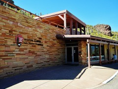 | Tonto National Monument Visitor Center | 0.2 miles | 2010 |
| Tonto National Monument, Upper Ruin (AZ U:8:048 ASM) | 0.2 miles | 1989 | |
| Theodore Roosevelt Dam National Register District | 3.7 miles | 1998 |
| National Archives record | The nomination case file for reference 89000265 in Record Group 79. |
| Gila County | All 43 listed properties in this county. |