
BlockBefore
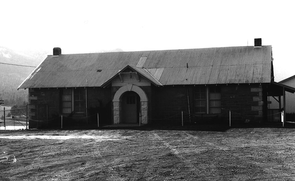
Photograph of Alpine Elementary School
Photograph by National Park Service, Public domain. Via Wikimedia Commons.

Alpine Elementary School

Built in 1930. Listed on the National Register of Historic Places in 1997.

From the record

“The Alpine Elementary School is a compound consisting of four buildings in Alpine, Arizona, operated by the public Alpine Elementary School District. The original school building of this complex was built in 1930, but a government-funded school had operated here since 1882.”

Wikipedia article Alpine Elementary School (Alpine, Arizona), CC BY-SA 4.0.

One of 24 National Register listings published here for Apache County · listed in 1997 · category: Building · built in 1930.

Sources: the Wikipedia article · the case file at the National Archives · the National Register database, National Park Service · the Wikipedia article

The listing

  • What is counted as historic. The nomination lists 2 buildingss as contributing to the listing.
  • Address. 11 and 12 Co. Rd. 2052, near jct. with US 180, Alpine, 85920
  • When was it listed? April 1997
  • Category. building
  • Census division. Eagar-Springerville
  • When was it built? 1930
  • National Register reference number. 97000369 - the number the National Park Service assigned this property when it was listed, and the key its nomination file is catalogued under at the National Archives.

Fires near this property

166 since 1992

Regional context, not property-specific evidence. The federal wildfire occurrence database lists 166 fires within 5 miles of Alpine Elementary School between 1992 and 2020, burning about 82 acres in total. 113 started naturally. 2 were recorded as arson. Distance is straight-line from the map coordinates, so a fire counted here may appear on a neighbouring settlement's page as well.

Reported cause Fires
Natural113
Missing data/not specified/undetermined22
Recreation and ceremony13
Debris and open burning5
Power generation/transmission/distribution4
Smoking3
Fireworks2
Equipment and vehicle use2
Arson/incendiarism2

The most recent of them, most recent first, with the day each was reported and the service that recorded it.

DateCause SizeReported by Name on the report
29 September 2000Naturalunder an acreApache-Sitgreaves National ForestXE
23 September 2001Recreation and ceremonyunder an acreApache-Sitgreaves National ForestCOYOTE
22 September 2000Recreation and ceremony2.0 acresApache-Sitgreaves National ForestLONG CANYON
2 September 2008Natural3.0 acresApache-Sitgreaves National ForestDIVIDE
2 September 2005Naturalunder an acreApache-Sitgreaves National ForestDRIZZLE
2 September 2000Naturalunder an acreApache-Sitgreaves National ForestLITTLE CREEK
19 September 2009Naturalunder an acreApache-Sitgreaves National ForestCORONADO
19 September 2000Natural1.0 acresApache-Sitgreaves National ForestHIGHWAY

Every fire recorded in Apache County

Mines and quarries near this property

1 within 5 miles

Regional context, not property-specific evidence. The federal mineral resources record lists 1 working within 5 miles of Alpine Elementary School: 1 occurrence. None of them still produces. What was taken out: Zeolites. Distance is straight-line from the map coordinates, so a quarry counted here may appear on a neighbouring settlement's page as well.

Where SiteCommodity StatusRecorded
AlpineZeolitesOccurrenceClinoptilolite

Every working recorded in Apache County

Storms near this property

14 since 2002

Regional context, not property-specific evidence. The National Weather Service names Alpine, the town this property stands in, in 14 storm reports between 2002 and 2013: 5 heavy rain, 5 flash flood, 3 hail, 1 tornado. No death or injury is recorded in these reports. Each account below is quoted exactly as the forecast office filed it, from the NOAA Storm Events Database, and each date opens the federal record of that event.

WhenEvent Place namedHarm What the report says
August 2011Flash FloodAlpine$20,000Arizona Department of Transportation reported flooding on Highway 180 from mile post 419 to 425. A motorcycle was swept away. The driver was able to escape. Water was flowing over subdivision streets on the north side of Alpine.
July 2011Flash FloodAlpine$20,000A flash flood and mud slide crossed Highway 191 just south of Alpine.
July 2011Flash FloodAlpine$10,000Spotters reported water, mud, and burn area debris/ash flowing across residential properties and threatening homes.
July 2011Flash FloodAlpine$5,000Apache Country Road 2153 (unmaintained) near Alpine flooded and was impassable.
July 2013Heavy RainAlpine-Two inches of rain fell in less than an hour in Alpine. Two to three inches of water covered the intersection of Highways 180 and 191.
January 2013Heavy RainAlpine-Rain showers developed over Apache County during the early hours of January 26 and continued through the 28th. The heaviest rain fell over orographically favored areas. The greatest rainfall totals include: 2 miles north of McNary 1.65 inches, Tsaile 1.15 inches, Canyon de Chelly 1.11 inches, and Window Rock Airport 1.09. The snow level remained high for most of this event. Snow reports include: Sunrise Ski 6.0 inches and Window Rock 3 inches.
August 2012Flash FloodAlpine-Heavy rain fell for 30 minutes northwest of Alpine. Three feet of water covered a country road. Highway 180 was also closed until the water receded and the debris was cleared.
August 2011Heavy RainAlpine-Heavy rain fell for about 45 minutes with a total of 0.65 in Alpine. Several County/Forest Service Roads and Highway 180 were flooded south of Alpine. One road was closed.
December 2007Heavy RainAlpine-Heavy rain fell across the lower elevations southern Apache County from December 7th through December 11th. About 3.50 inches of rain and melted snow fell just north of McNary.
September 2007HailAlpine-Nickel to quarter sized (7/8 inch to 1 inch diameter) hail fell in Alpine. The nickel sized hail covered the ground to at least one inch deep. Two inches of rain were also reported with this storm. However, no damage wes reported.
December 2007Heavy RainAlpine-Heavy rain fell over Apache county during the day. Some rainfall totals include: Pine Hill (RAWS) 0.80, Window Rock Airport 0.65, St Johns Airport 0.40, Alpine. 1.80, and Greer 0.90.
August 2006Tornado (F0)Alpine-A waterspout formed over the west end of Big Lake (about 15 miles west of Alpine). The spout lifted water into the air then moved into the forest.
August 2004HailAlpine-3/4 inch diameter hail was reported at the Alpine Ranger Station for half an hour.
August 2002HailAlpine-One inch hail fell for six minutes in Alpine.

Every storm recorded in Apache County

Map coverage status

No historic map-sheet match is published for this property yet. That does not mean no map exists. This record needs a coordinate-quality review before it can be joined to a sheet boundary. Browse the county's mapped places while that work is pending.

Sources for this property

National Archives recordThe nomination case file for reference 97000369 in Record Group 79.
Wikipedia articleCommunity-written account of this property, licensed CC BY-SA.
Apache CountyAll 24 listed properties in this county.

Provenance

  • Listing record. National Park Service National Register of Historic Places, listed-properties dataset, current to 2026-05-22.
  • Map join. Address geocoded through the United States Census geocoder, then tested against the published boundary of every sheet in the USGS Historical Topographic Map Collection.
  • How this page is made. Listing fields come from federal records; map-sheet coverage is a labelled coordinate-to-boundary calculation, not a source-field claim.
  • Wildfire. Short, Karen C. 2022. Spatial wildfire occurrence data for the United States, 1992-2020 [FPA_FOD_20221014]. 6th Edition. Fort Collins, CO: Forest Service Research Data Archive. https://doi.org/10.2737/RDS-2013-0009.6 Collected with United States Government funding and usable without additional permissions or fees.
  • Mines and quarries. USGS Mineral Resources Data System (MRDS) https://mrdata.usgs.gov/mrds/ A work of the United States government, no copyright under 17 U.S.C. 105.
  • Storms. NOAA National Centers for Environmental Information, Storm Events Database https://www.ncei.noaa.gov/stormevents/ A work of the United States government, no copyright under 17 U.S.C. 105. Narratives are quoted verbatim from the National Weather Service report and are not edited or summarised.