Listed on the National Register of Historic Places in 1998.
From the record
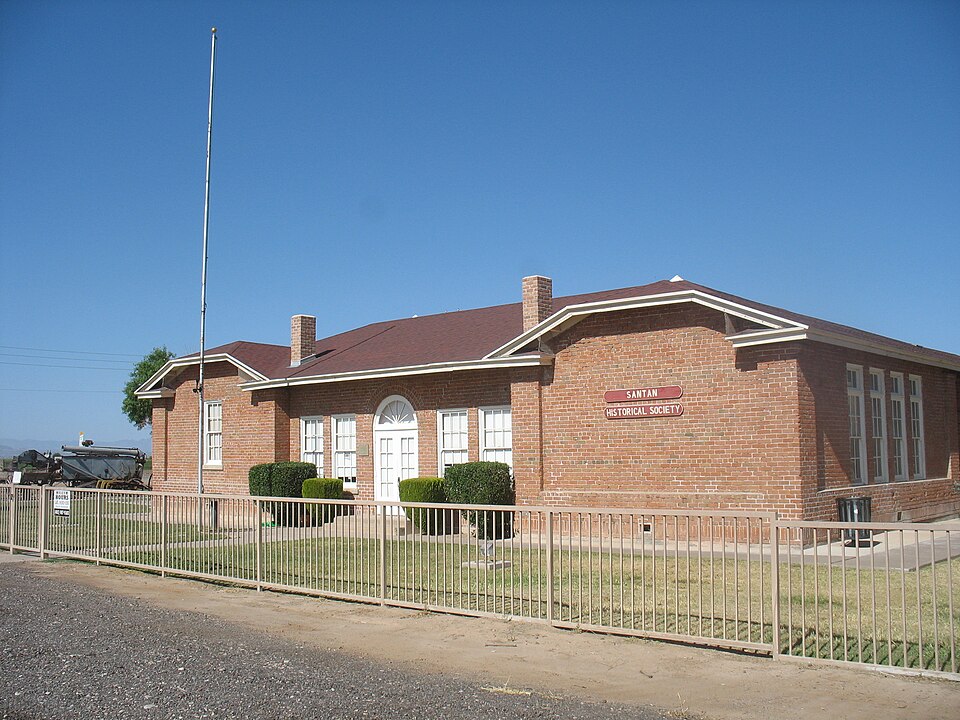
“The Rittenhouse Elementary School, now the San Tan Historical Society Museum, is a well-preserved historic school located at 20425 South Ellsworth Road at the intersection with East Queen Creek Road in Queen Creek, Arizona. It was built from 1924 to 1925 in the Spanish Colonial Revival style, opened for classes in 1926, and closed in 1982, after which it was used for storage by the Queen Creek Unified School District.”
Wikipedia article Rittenhouse Elementary School, CC BY-SA 4.0.
One of 467 National Register listings published here for Maricopa County · listed in 1998 · category: Building.
National Register reference number.98000053- the number the National Park Service assigned this property when it was listed, and the key its nomination file is catalogued under at the National Archives.
Fires near this property
131 since 1992
Regional context, not property-specific
evidence. The
federal wildfire occurrence database
lists 131 fires within 5 miles of Rittenhouse Elementary School
between 1992 and 2020, burning about 306 acres in total. 2 started naturally. 7 were recorded as arson.
Distance is straight-line from the map coordinates, so a fire counted
here may appear on a neighbouring settlement's page as well.
Reported cause
Fires
Missing data/not specified/undetermined
117
Arson/incendiarism
7
Equipment and vehicle use
2
Natural
2
Misuse of fire by a minor
1
Debris and open burning
1
Railroad operations and maintenance
1
The most recent of
them, most recent first, with the day each was reported and the service
that recorded it.
Date
Cause
Size
Reported by
Name on the report
30 September 2018
Missing data/not specified/undetermined
under an acre
Queen Creek Fire Department
77540
27 September 2019
Missing data/not specified/undetermined
under an acre
Arizona Department of Forestry and Fire Management - State Office
NOT NAMED
21 September 2018
Missing data/not specified/undetermined
under an acre
Queen Creek Fire Department
74993
20 September 2020
Missing data/not specified/undetermined
under an acre
Arizona Department of Forestry and Fire Management - State Office
not named
17 September 2020
Missing data/not specified/undetermined
under an acre
Arizona Department of Forestry and Fire Management - State Office
not named
16 September 1994
Debris and open burning
2.0 acres
Arizona Department of Forestry and Fire Management - State Office
not named
11 September 2015
Missing data/not specified/undetermined
under an acre
Arizona Department of Forestry and Fire Management - State Office
155073
23 August 2019
Missing data/not specified/undetermined
under an acre
Arizona Department of Forestry and Fire Management - State Office
Regional context, not property-specific
evidence. The federal mineral resources record lists
4 workings within 5 miles of Rittenhouse Elementary School: 2 occurrences, 1 producer, 1 prospect.
1 still produces. What was taken out: Gypsum-Anhydrite, Marble, Dimension, Geothermal. Distance is straight-line from the
map coordinates, so a quarry counted here may appear on a neighbouring
settlement's page as well.
Regional context, not property-specific
evidence. The National Weather Service names
Queen Creek, the town this property stands in, in 17 storm reports between 1995 and 2022: 10 thunderstorm wind, 3 hail, 1 funnel cloud, 1 heavy rain.
No death or injury is recorded in these reports. Each account below is quoted exactly as the forecast office
filed it, from the NOAA Storm Events Database, and each date
opens the federal record of that event.
Severe thunderstorms struck this area with high winds blowing down power poles and lines. Homes and businesses were damaged. Salt River Project reported about 200 power poles down in the area near Ellsworth and Ocotillo road, Up to 5,000 customers were left without power. Power was restored the following day to 2,000 households and fully restored by Monday. Hundreds of mature trees blown down and onto streets and homes. Windshields on a number of vehicles were blown out. Winds caused a building to collapse, killing a horse. Several aircraft were overturned by high winds, and a construction trailer in Queen Creek was destroyed.
A wet microburst hit the town of Queen Creek. A tree was blown over onto a house. A large potato storage shed was destroyed. Wood and metal from the shed along with hail were blown into 12 nearby school buses damaging them all. An office roof was torn off at Queen Creek High School. The high school also had four other roofs and numerous air conditioning units damaged as well as broken windows. An estimated 4,000 to 6,000 acres of cotton in nearby fields were destroyed by wind and hail.
A large Pacific upper low moving east across Arizona was accompanied by a strong cold front that moved across the greater Phoenix metropolitan area during the early morning hours on November 29th. Due to high levels of wind shear and instability, the front generated several tornadoes, one of which briefly moved through the community of Queen Creek at around 0450MST. According to a NWS employee, the tornado resulted in moderate damage, downing a number of trees as well as knocking down several power poles. Some roof damage was also noted. Fortunately there were no injuries reported. Damage surveys indicated that the tornado was on the ground less than 10 minutes and had a short path, with a width between 50 and 100 yards.
Isolated to scattered thunderstorms developed across portions of the greater Phoenix metropolitan area during the late evening hours on August 14th. Partly due to the excessive heat that occurred during the day, the thunderstorms were able to generate strong, gusty and damaging microburst winds well into the evening hours. According to Brad Greer, Park Ranger with the town of Queen Creek, a large metal football light field pole was blown down during the evening thunderstorms. Time of the storms was estimated to be near 1030 pm, and the wind gusts were estimated to be at least 65 knots. The light pole was located at the Queen Creek Middle School in Queen Creek, at the intersection of Queen Creek and Ellsworth Roads. Fortunately, no injuries occurred due to the falling light pole.
Heavy rains fell at Queen Creek, with 1.61 inches at the Queen Creek landfill and 1.54 inches at East Maricopa Floodway and Queen Creek Road. High water forced road closures at Hunt and Ellsworth and the Magic Ranch subdivision. At least one car stalled in high water at Hunt Highway and Hawes.
Thunderstorms with strong gusty outflow winds developed over the southeast portion of the greater Phoenix area during the late evening hours on August 9th, and some of the storms continued through midnight and into the very early morning hours on August 10th. Some of the stronger storms affected the town of Queen Creek. According to a report from the public, at about midnight, or 0000MST, gusty winds estimated to be as high as 70 mph snapped in half 3 Palo Verde Trees in Queen Creek. The trees were snapped just south of the Queen Creek Middle School and just southeast of the intersection of the Ellsworth Loop Road and Queen Creek Road. A Severe Thunderstorm Warning was not in effect at the time.
Video on social media showed hail of various sizes falling in Queen Creek near Ocotillo Rd. with the largest hail stones estimated by the user at 1 inch diameter. No damages or injuries were reported.
Showers and thunderstorms were scattered across portions of the county, with brief heavy rainfall in localized areas. Hurricane Ileana, spinning in the eastern Pacific, produced impulses that passed through the state. These impulses, together with a very moist airmass, helped trigger these storms.A spotter in East Mesa reported .5 inch of rain in only 15 minutes. An automatic gauge in Queen Creek picked up over 2 inches and a spotter in Wickenburg reported .62 inch of rain in less than one hour. One of the heaviest rainfall rates was reported in East Phoenix. Runoff from these heavy rains led to a rapid rise in the Indian Bend Wash during the day. At one time there was about 4 feet of water. Two motorists had to be rescued from their vehicles. Lightning sparked several fires and caused spotty power and phone outages.
A wet microburst hit the town of Queen Creek. A tree was blown over onto a house. A large potato storage shed was destroyed. Wood and metal from the shed along with hail were blown into 12 nearby school buses damaging them all. An office roof was torn off at Queen Creek High School. The high school also had four other roofs and numerous air conditioning units damaged as well as broken windows. An estimated 4,000 to 6,000 acres of cotton in nearby fields were destroyed by wind and hail.
No historic map-sheet match is published
for this property yet. That does not mean no map exists. This record needs
a coordinate-quality review before it can be joined to a sheet boundary.
Browse the county's mapped places while that work is
pending.
Listed places nearby
6 within 8 miles
Other National Register properties close
enough to walk or drive between, ordered by distance from this one. Both
positions come from the same geocoding pass that matched these properties
to their map sheets.
Listing record. National Park Service National Register of Historic Places, listed-properties dataset, current to 2026-05-22.
Map join. Address geocoded through the United States Census geocoder, then tested against the published boundary of every sheet in the USGS Historical Topographic Map Collection.
How this page is made. Listing fields come from federal records; map-sheet coverage is a labelled coordinate-to-boundary calculation, not a source-field claim.
Wildfire. Short, Karen C. 2022. Spatial wildfire occurrence data for the United States, 1992-2020 [FPA_FOD_20221014]. 6th Edition. Fort Collins, CO: Forest Service Research Data Archive. https://doi.org/10.2737/RDS-2013-0009.6 Collected with United States Government funding and usable without additional permissions or fees.
Mines and quarries. USGS Mineral Resources Data System (MRDS) https://mrdata.usgs.gov/mrds/ A work of the United States government, no copyright under 17 U.S.C. 105.
Storms. NOAA National Centers for Environmental Information, Storm Events Database https://www.ncei.noaa.gov/stormevents/ A work of the United States government, no copyright under 17 U.S.C. 105. Narratives are quoted verbatim from the National Weather Service report and are not edited or summarised.
 Block