 Block
From the record
One of 43 National Register listings published here for Gila County · listed in 1999 · category: Building.
Sources: the case file at the National Archives · the National Register database, National Park Service
Listed on the National Register of Historic Places in 1999.
One of 43 National Register listings published here for Gila County · listed in 1999 · category: Building.
Sources: the case file at the National Archives · the National Register database, National Park Service
Regional context, not property-specific evidence. The federal wildfire occurrence database lists 89 fires within 5 miles of Perkins Store between 1992 and 2020, burning about 86 acres in total. 50 started naturally. 10 were recorded as arson. Distance is straight-line from the map coordinates, so a fire counted here may appear on a neighbouring settlement's page as well.
| Reported cause | Fires |
|---|---|
| Natural | 50 |
| Missing data/not specified/undetermined | 16 |
| Arson/incendiarism | 10 |
| Debris and open burning | 6 |
| Recreation and ceremony | 3 |
| Power generation/transmission/distribution | 1 |
| Smoking | 1 |
| Misuse of fire by a minor | 1 |
| Equipment and vehicle use | 1 |
The most recent of them, most recent first, with the day each was reported and the service that recorded it.
| Date | Cause | Size | Reported by | Name on the report |
|---|---|---|---|---|
| 8 September 2011 | Natural | under an acre | Tonto National Forest | CLINE |
| 7 September 2002 | Natural | under an acre | Tonto National Forest | NAIL |
| 6 September 2008 | Arson/incendiarism | under an acre | Tonto National Forest | PIT |
| 29 September 2012 | Debris and open burning | under an acre | Tonto National Forest | PIT 2 |
| 16 September 1995 | Natural | under an acre | Tonto National Forest | GENTRY |
| 10 September 2009 | Natural | under an acre | Tonto National Forest | CROUCH |
| 9 August 1993 | Natural | 4.0 acres | Tonto National Forest | not named |
| 8 August 1997 | Natural | under an acre | Tonto National Forest | BROWNING |
Regional context, not property-specific evidence. The federal mineral resources record lists 5 workings within 5 miles of Perkins Store: 2 occurrences, 2 prospects, 1 past producer. None of them still produces. What was taken out: Garnet, Fluorine-Fluorite, Barium-Barite, Manganese, Copper. Distance is straight-line from the map coordinates, so a quarry counted here may appear on a neighbouring settlement's page as well.
| Where | Site | Commodity | Status | Recorded |
|---|---|---|---|---|
| Garnet Occurrence | Garnet | Occurrence | Garnet, Magnetite | |
| Gravel Pit | Sand and Gravel, Construction | Past Producer | ||
| Jones Barite-Fluorite | Fluorine-Fluorite, Barium-Barite, Manganese | Occurrence | Vein | |
| Jones Barite-Fluorite | Copper, Barium-Barite, Fluorine-Fluorite | Prospect | ||
| Nail Ranch Hematite | Iron | Prospect |
Regional context, not property-specific evidence. The National Weather Service names Young, the town this property stands in, in 12 storm reports between 2000 and 2024: 4 hail, 2 thunderstorm wind, 2 flash flood, 1 wildfire. No death or injury is recorded in these reports. Each account below is quoted exactly as the forecast office filed it, from the NOAA Storm Events Database, and each date opens the federal record of that event.
| When | Event | Place named | Harm | What the report says |
|---|---|---|---|---|
| July 2024 | Thunderstorm Wind | Young | - | A thunderstorm produced wind gust of at least 63 MPH, heavy rain (0.76 inch in 75 minutes), thunder, and lightning. A building on Moon Drive and Highway 288 lost the roof, power lines were damaged, and a hay shed was damaged. |
| August 2018 | Hail | Young | - | Hail damaged (dimple) the hood of a car as it traveled through the town of Young. |
| August 2018 | Funnel Cloud | Young | - | Pictures of a funnel cloud were relayed to the National Weather Service. The time and location of the funnel cloud were estimated by using radar. |
| August 2016 | Flash Flood | Young | - | The USGS stream gauge at Cherry Creek measured a 6 foot rise with a peak stage of 8.07 feet (4,800 CFS). Base flow is less than 10 CFS. |
| August 2012 | Flash Flood | Young | - | Heavy rain over the Fire area caused a mud and rock slide over Road 512 (Heber-Young Road). Road crews were called to clear the mud and debris from the road. |
| January 2010 | Heavy Rain | Young | - | A strong winter storm produced 4.01 inches of precipitation in 24 hours. Rainfall over a three day period ranged from 6 to 10 inches across Gila Country. |
| July 2007 | Hail | Young | - | A thunderstorm produced nickle sized hail in Young. |
| September 2004 | Tornado (F0) | Young | - | A tornado touched down about 12 miles northeast of Young along the Young-Heber Highway near Forest Service Road 188. Trees were sheared off and the road was blocked. |
| August 2003 | Hail | Young | - | Quarter sized (one inch diameter) was reported in Pleasant Valley near Young. |
| July 2003 | Hail | Young | - | One inch diameter hail was reported in the town of Young. |
| July 2001 | Thunderstorm Wind | Young | - | A thunderstorm moved through Young with wind between 50 and 60 MPH. The wind blew lawn chairs around, knocked down a 40 meter antenna, blew off the roof of a house trailer, and two other buildings sustained roof damage. |
| July 2000 | Wildfire | Young | - | The Tanner Fire was caused by lightning on July 10 about 20 miles south of Young. The fire was contained on July 13 after 316 acres had burned. |
No historic map-sheet match is published for this property yet. That does not mean no map exists. This record needs a coordinate-quality review before it can be joined to a sheet boundary. Browse the county's mapped places while that work is pending.
Other National Register properties close enough to walk or drive between, ordered by distance from this one. Both positions come from the same geocoding pass that matched these properties to their map sheets.
| Photograph | Property | Distance | Listed |
|---|---|---|---|
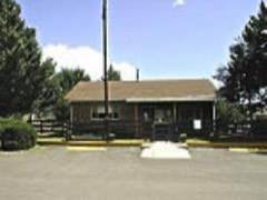 | Pleasant Valley Ranger Station | 1.7 miles | 1993 |
| National Archives record | The nomination case file for reference 99000108 in Record Group 79. |
| Gila County | All 43 listed properties in this county. |