BlockBefore
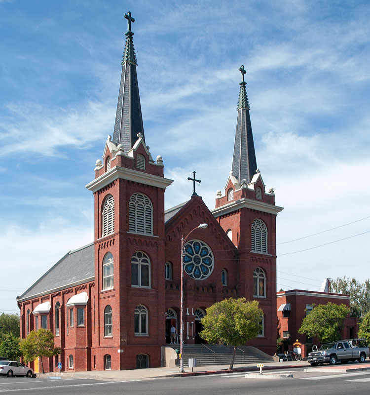
Photograph of Saint Mary's Parish
Photograph by NoeHill, CC BY-SA 3.0. Via Wikimedia Commons.

Saint Mary's Parish

Listed on the National Register of Historic Places in 1982. 7 historic topographic surveys show this location, the earliest from 1890.

From the record

One of 9 National Register listings published here for Tehama County · listed in 1982 · category: Building.

Sources: the case file at the National Archives · the National Register database, National Park Service · the Wikipedia article

The listing

  • What is counted as historic. The nomination lists 1 building as contributing to the listing.
  • Address. 515 Main St., Red Bluff, 96080
  • When was it listed? February 1982
  • Category. building
  • Census division. Red Bluff
  • Architectural style. Romanesque Revival architecture
  • Architect. W. H. Weeks
  • National Register reference number. 82002278 - the number the National Park Service assigned this property when it was listed, and the key its nomination file is catalogued under at the National Archives.

Fires near this property

807 since 1992

Regional context, not property-specific evidence. The federal wildfire occurrence database lists 807 fires within 5 miles of Saint Mary's Parish between 1992 and 2020, burning about 6,194 acres in total. 15 started naturally. 62 were recorded as arson. Distance is straight-line from the map coordinates, so a fire counted here may appear on a neighbouring settlement's page as well.

Reported cause Fires
Missing data/not specified/undetermined319
Equipment and vehicle use221
Debris and open burning91
Arson/incendiarism62
Smoking45
Misuse of fire by a minor36
Natural15
Power generation/transmission/distribution12
Recreation and ceremony3
Firearms and explosives use1
Fireworks1
Railroad operations and maintenance1

The most recent of them, most recent first, with the day each was reported and the service that recorded it.

DateCause SizeReported by Name on the report
9 September 2020Smoking1.0 acresTehama-Glenn UnitBAKER RD WRB
9 September 2007Missing data/not specified/undeterminedunder an acreTehama-Glenn UnitJELLYS2
9 September 2000Equipment and vehicle useunder an acreTehama-Glenn UnitPG&E
9 September 1995Equipment and vehicle use2.0 acresTehama-Glenn UnitMISSION
9 September 1993Smoking2.0 acresTehama-Glenn UnitRAWSON
8 September 2020Missing data/not specified/undetermined1.0 acresTehama-Glenn UnitCAROL AV RBCTY
8 September 2020Missing data/not specified/undetermined1.0 acresTehama-Glenn UnitHILL ST RBCTY
8 September 1994Equipment and vehicle use1.0 acresTehama-Glenn UnitCONRAD

Every fire recorded in Tehama County

Mines and quarries near this property

10 of 13 shown

Regional context, not property-specific evidence. The federal mineral resources record lists 13 workings within 5 miles of Saint Mary's Parish: 10 producers, 2 past producers, 1 prospect. 10 still produce. What was taken out: Sand and Gravel, Construction, Clay. Distance is straight-line from the map coordinates, so a quarry counted here may appear on a neighbouring settlement's page as well.

Where SiteCommodity StatusRecorded
O'Connor Bros.ClayProspect
Al' Bon's CrusherSand and Gravel, ConstructionProducer
Chase PitSand and Gravel, ConstructionProducer
Dibble Creek PitSand and Gravel, ConstructionProducer
Draper and AdamsSand and Gravel, ConstructionPast Producer
Fredrickson and WestbrookSand and Gravel, ConstructionPast Producer
Heitman Dibble Creek BarSand and Gravel, ConstructionProducer
Latten Pit and MilSand and Gravel, ConstructionProducer
Old Red Bluff Rock SiteSand and Gravel, ConstructionProducer
Red Bank Creed SiteSand and Gravel, ConstructionProducer

Every working recorded in Tehama County

Storms near this property

21 since 2000

Regional context, not property-specific evidence. The National Weather Service names Red Bluff, the town this property stands in, in 21 storm reports between 2000 and 2025: 11 flood, 4 flash flood, 3 hail, 2 wildfire. No death or injury is recorded in these reports. Each account below is quoted exactly as the forecast office filed it, from the NOAA Storm Events Database, and each date opens the federal record of that event.

WhenEvent Place namedHarm What the report says
September 2000WildfireRed Bluff$547,000,000no account filed
December 2014Flash FloodRed Bluff$6,000,000There was flooding and impacts along Highway 99 from numerous creeks overtopping their banks in addition to earthen berm or earthen levee failures. There were issues on the following creeks: | Salt Creek (Overtopped at Highway 99 and Highway 36 location)| Antelope Creek (Private earthen berm failure at Rancho Ave))| Craig Creek (Overtopped near Craig Road and Rancho Ave)| Dye Creek (Over topped and earthen berm failure between Shasta blvd and 62nd Ave)|Highway 99 was closed from highway 36 to Aramayo Way for many hours (Wednesday evening through early Thursday morning) until the water receded and things could be cleaned up. There were 213 homes impacted from the flooding, with significant damage from water and mud. Many homes had several feet of water. Fields and orchards were also flooded.|Damage to homes, bridges, fencing, crops, and beehives totaled $2.5 million. Repairs and remediation to the berms totaled $4.25 million.
October 2000WildfireRed Bluff$547,000no account filed
January 2019FloodRed Bluff$15,000Heavy rains led to intense flooding in Red Bluff leading to 30 homes being evacuated on Aloha Street. Several homes did flood and evacuation orders were lifted at 1100 am.
February 2025FloodRed Bluff-California Highway Patrol reported roadway flooding at State Route 36 and North Main Street from heavy rain.
February 2025FloodRed Bluff-California Highway Patrol reported roadway flooding from heavy rain at State Route 36 and Monroe Avenue near Red Bluff.
February 2025FloodRed Bluff-California Highway Patrol reported roadway flooding on State Route 36 at Monroe Avenue near Red Bluff from heavy rain.
November 2024FloodRed Bluff-California Highway Patrol reported flooding along CA-99 from Aramayo Way in Los Molinos to CA-36 near Red Bluff. There was over 1 foot of water in the roadway with multiple vehicles stuck in the road. Flooding led to a closure of CA-99.
December 2024FloodRed Bluff-California Highway Patrol reported roadway flooding on State Route 36 and Antelope Boulevard from heavy rain.
January 2023FloodRed Bluff-Eastbound highway 36 was closed by Baker Road for about an hour. Red Bluff Airport received 0.42 inches of rain between 9 and 10 am, and 0.97 inches over 6 hours.
March 2023FloodRed Bluff-California Highway Patrol reported roadway flooding between Antelope Boulevard and Gilmore Road.
February 2019FloodRed Bluff-From route 36 to Aramayo Way the road was closed to numerous reports of flooding. Reports of flooding started coming in at 3am and were still present at 4:50pm.
February 2017FloodRed Bluff-Flooding issues on Paynes Creek Slough caused Kaer Ave. to be impassable.
October 2015Heavy RainRed Bluff-Locally heavy rain from a thunderstorm, with 1.25 inches measured in about 30 minutes.
December 2014FloodRed Bluff-Highway 99 eastbound at Long Creek Bridge. Flooding was a few feet deep.
December 2014Flash FloodRed Bluff-Flash flooding caused a hard closure of Highway 36 at Baker Road.
December 2014Flash FloodRed Bluff-Tehama County Sheriff's Office reported flooding of roads at multiple locations. Received a report of up to 6 feet of water flowing over a road. Closed a stretch of Highway 36.
December 2014Flash FloodRed Bluff-Mudslide reported near the intersection of Baker Rd. and Monrovia.
February 2001HailRed Bluff-no account filed
July 2000HailRed Bluff-no account filed

Every storm recorded in Tehama County

Maps showing this location

7 surveys

United States Geological Survey topographic sheets whose coverage includes this point. Matched by taking the coordinate the National Park Service records for this property, then testing that coordinate against the published boundary of every sheet.

Listed places nearby

5 within 8 miles

Other National Register properties close enough to walk or drive between, ordered by distance from this one. Both positions come from the same geocoding pass that matched these properties to their map sheets.

Photograph PropertyDistance Listed
Odd Fellows Buildingunder 500 feet1976
State Theatreunder 500 feet2002
Old Bank of America Building0.2 miles1980
Cone and Kimball Building0.2 miles1979
Herbert Kraft Memorial Free Library0.3 miles2000

Sources for this property

National Archives recordThe nomination case file for reference 82002278 in Record Group 79.
Wikipedia articleCommunity-written account of this property, licensed CC BY-SA.
Tehama CountyAll 9 listed properties in this county.

Provenance

  • Listing record. National Park Service National Register of Historic Places, listed-properties dataset, current to 2026-05-22.
  • Map join. Address geocoded through the United States Census geocoder, then tested against the published boundary of every sheet in the USGS Historical Topographic Map Collection.
  • How this page is made. Listing fields come from federal records; map-sheet coverage is a labelled coordinate-to-boundary calculation, not a source-field claim.
  • Wildfire. Short, Karen C. 2022. Spatial wildfire occurrence data for the United States, 1992-2020 [FPA_FOD_20221014]. 6th Edition. Fort Collins, CO: Forest Service Research Data Archive. https://doi.org/10.2737/RDS-2013-0009.6 Collected with United States Government funding and usable without additional permissions or fees.
  • Mines and quarries. USGS Mineral Resources Data System (MRDS) https://mrdata.usgs.gov/mrds/ A work of the United States government, no copyright under 17 U.S.C. 105.
  • Storms. NOAA National Centers for Environmental Information, Storm Events Database https://www.ncei.noaa.gov/stormevents/ A work of the United States government, no copyright under 17 U.S.C. 105. Narratives are quoted verbatim from the National Weather Service report and are not edited or summarised.