 Block
From the record
3 National Register listings published here.
Sources: the National Register database, National Park Service
67 topographic sheets cover 23 settlements here, and 3 properties are on the National Register of Historic Places.
3 National Register listings published here.
Sources: the National Register database, National Park Service
Every property in this county listed on the National Register of Historic Places, with the year it was listed and the federal nomination document.
| Photograph | Property | Type | Listed | Reference |
|---|---|---|---|---|
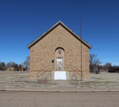 | Springfield Schoolhouse | building | 1977 | 77000363 |
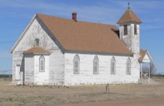 | Stonington First Methodist-Episcopal Church | building | 1996 | 96000272 |
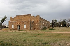 | Two Buttes Gymnasium | building | 2009 | 09001119 |
Every wildfire the federal occurrence database records inside this county: 395 of them, burning about 105,886 acres. 116 started naturally and 6 were recorded as arson. Each settlement page carries the fires within five miles of it.
| Reported cause | Fires |
|---|---|
| Missing data/not specified/undetermined | 162 |
| Natural | 116 |
| Recreation and ceremony | 32 |
| Equipment and vehicle use | 30 |
| Debris and open burning | 29 |
| Smoking | 8 |
| Arson/incendiarism | 6 |
| Misuse of fire by a minor | 5 |
| Power generation/transmission/distribution | 4 |
| Railroad operations and maintenance | 2 |
| Fireworks | 1 |
The five largest, by the area the report gives. None of them was recorded as arson.
| Date | Cause | Size | Reported by | Name on the report |
|---|---|---|---|---|
| 17 April 2018 | Missing data/not specified/undetermined | 50,671 acres | Baca County Office | BADGER HOLE |
| 10 March 2018 | Equipment and vehicle use | 17,650 acres | Pike and San Isabel National Forest | STATELINE |
| 20 November 2006 | Equipment and vehicle use | 4,000 acres | Pike and San Isabel National Forest | MOUNT CARMEL |
| 13 February 2019 | Smoking | 3,813 acres | Pike and San Isabel National Forest | C34 |
| 8 December 2017 | Missing data/not specified/undetermined | 3,134 acres | Baca County Office | WINDSPLITTER |
| 27 July 2019 | Natural | 1,641 acres | Pike and San Isabel National Forest | REGISTER SPRING |
| 24 July 2005 | Missing data/not specified/undetermined | 1,500 acres | Colorado State Forest Service-State Headquarters | not named |
| 26 May 2002 | Natural | 1,350 acres | Pike and San Isabel National Forest | KIRKWELL |
Every settlement page carries the fires within five miles of it - see the settlement index below.
The NOAA Storm Events Database holds 621 reports for this county, causing 1 death, 6 injuries and about $5,677,000 in recorded property damage. Each settlement page carries the reports that name it.
| Kind of event | Reports |
|---|---|
| Hail | 399 |
| Thunderstorm Wind | 103 |
| Tornado | 84 |
| Funnel Cloud | 15 |
| Flash Flood | 10 |
| Heavy Rain | 7 |
| Flood | 1 |
| Dust Devil | 1 |
| Lightning | 1 |
The most serious of them, by death, then injury, then recorded damage. The accounts are quoted exactly as the forecast office filed them.
| When | Event | Place named | Harm | What the report says |
|---|---|---|---|---|
| July 2014 | Thunderstorm Wind | Vilas | 1 killed, $30,000 | High end EF1 damage occurred with a very compact microburst. A manufactured home was completely destroyed, along with three power poles. |
| June 1967 | Tornado (F2) | not stated | 4 hurt, $250,000 | no account filed |
| June 2017 | Thunderstorm Wind | Walsh | 2 hurt, $2,000,000 | Trees and tree limbs down, causing damage to power lines, structures and vehicles. Two people sustained very minor injuries. |
| May 1977 | Tornado (F4) | not stated | $2,500,000 | no account filed |
| May 2010 | Hail | Springfield | $250,000 | Damaging large hail occurred in Springfield and north-northwest of town over a half hour time frame. |
| May 2003 | Tornado (F2) | Springfield | $125,000 | A tornado moved northeast across a rural area, but did strike the county gravel pit and a few ranches. Approximately 1 1/2 miles of utility poles were brought down by the tornado and rear flank downdraft along U.S. Highway 160. At the gravel pit north of the highway, gravel screening machinery sustained heavy damage. Farther to the northeast a sheet metal building with a steel girder frame was a total loss. |
| September 2004 | Hail | Springfield | $100,000 | Hail occurred for nearly an hour, ranging from one inch to 1.75 inches in diameter. |
| August 2008 | Thunderstorm Wind | Springfield | $50,000 | Several airport hangars were destroyed and a few planes were damaged at the Springfield Airport due to a powerful microburst. |
| June 2006 | Hail | Campo | $50,000 | no account filed |
| June 2017 | Thunderstorm Wind | Walsh | $30,000 | Three quarters of a mile of power poles were snapped off. |
| May 2010 | Tornado (EF2) | Campo | $30,000 | A tornado moved southeast, crossing US Highway 287 south of Campo. Eight power poles were snapped off west of the highway and on County Road C. Two windmills were also hit, and a storage shed was tipped over and moved 20 feet. The tornado ended shortly before the Oklahoma state line. |
| June 2009 | Thunderstorm Wind | (Kspd)Springfield Awos | $30,000 | Five power poles were snapped off at the bases along highway 287...and around 20 powerpoles were taken down on County Road 35. |
| June 2017 | Thunderstorm Wind | Walsh | $25,000 | One half mile of pivot irrigation was damaged and destroyed, and a roof was partially lifted off a barn. |
| June 1999 | Tornado (F1) | Walsh | $25,000 | A supercell which moved southeast through Baca county produced the following three tornados. A tornado began just northwest of the intersection of county road R and country road 42. It moved southeast and struck a ranch complex, destroying a concrete block garage and damaging a vehicle inside. Roof damage was done to the nearby house. The tornado continued to move southeast, then almost due south between ranch houses before lifting 7 miles after initial touchdown. |
| June 1992 | Tornado (F1) | not stated | $25,000 | no account filed |
| May 1969 | Tornado (F1) | not stated | $25,000 | no account filed |
| June 2015 | Thunderstorm Wind | Springfield | $20,000 | Damaging winds occurred in Springfield, of note, at the Fairgrounds and High School. |
| May 2010 | Tornado (EF2) | Pritchett | $20,000 | A large, slowing moving tornado moved south across open fields and US Highway 160, snapping off 14 power poles. |
| June 2015 | Thunderstorm Wind | Springfield | $15,000 | Damaging winds knocked down 10 power poles along Highway 160. |
| May 2010 | Tornado (EF0) | Walsh | $10,000 | A tornado moved northwest and damaged a mobile home and some outbuildings, then moved over open fields. |
| May 2012 | Dust Devil | Pritchett | $10,000 | no account filed |
| May 2010 | Tornado (EF1) | Springfield | $9,000 | A tornado traveled north-northwest for approximately 8 miles, moving a hay swather, and taking down five power poles. |
| June 2012 | Thunderstorm Wind | Two Buttes | $5,000 | Eight power poles were blown down near the intersection of County Roads 39 and KK. |
| May 2010 | Tornado (EF1) | Walsh | $5,000 | A large tornado moved north northwest and damaged fencing and uprooted cottonwood trees along Bear Creek northwest of Bartlett. |
| June 2005 | Tornado (F0) | Campo | $5,000 | A tornado was seen in the vicinity of mile marker 15 on U.S. 287 and knocked down some power poles. |
| June 2005 | Tornado (F0) | Two Buttes | $5,000 | A tornado downed large tree limbs and destroyed some weak outbuildings at a ranch. |
| May 1994 | Thunderstorm Wind | Springfield to | $5,000 | Straight-line thunderstorm winds overturned a semi hauling 720 pounds of methane alcohol on Colorado Highway 287 south of Springfield. The driver was unhurt. The winds also damaged feeders, grain augers and a windmill on several farms south and southeast of Springfield, as well as knocking down fences, power lines and trees. |
| June 2011 | Thunderstorm Wind | Stonington | $5,000 | no account filed |
| May 2015 | Tornado (EF1) | Stonington | $3,000 | A short-lived tornado struck a windmill in open country of southeast Baca County. |
| June 1982 | Tornado (F1) | not stated | $2,500 | no account filed |
| May 1979 | Tornado (F1) | not stated | $2,500 | no account filed |
| July 1968 | Tornado (F0) | not stated | $2,500 | no account filed |
| June 2017 | Tornado (EF0) | Walsh | $2,000 | A tornado, at one time multiple-vortex, did some damage to fencing as it moved mainly across open fields around 3 miles west of Walsh and crossed US Highway 160. |
| July 2015 | Thunderstorm Wind | Stonington | $2,000 | A pole barn was damaged. |
| May 2015 | Lightning | Stonington | $1,500 | Three horses were killed by lightning. |
| July 2015 | Thunderstorm Wind | Springfield | $1,000 | High winds downed many tree branches, some up to 6 inches in diameter, and caused minor damage to a house. |
| April 1971 | Tornado (F0) | not stated | $250 | no account filed |
| June 1962 | Tornado (F1) | not stated | $250 | no account filed |
| May 1962 | Tornado (F1) | not stated | $250 | no account filed |
| June 1957 | Tornado (F1) | not stated | $250 | no account filed |
| June 2025 | Hail | (Kspd)Springfield Awos | - | Hail up to 1 inch in diameter fell in central Baca County from a supercell thunderstorm. |
| June 2025 | Hail | Campo | - | Hail up to 1 inch in diameter fell in central Baca County from a supercell thunderstorm. |
| June 2025 | Hail | Pritchett | - | Hail up to 1.75 inches in diameter fell in Baca County from a supercell thunderstorm. |
| June 2025 | Hail | Campo | - | Hail up to 2 inches in diameter fell in far western Baca County from a supercell thunderstorm. |
| June 2025 | Hail | Campo | - | Hail up to 2.75 inches in diameter fell in Baca County from a supercell thunderstorm. |
| June 2025 | Thunderstorm Wind | (Kspd)Springfield Awos | - | Reported 64 mph with gusts from kspd asos. |
| June 2025 | Thunderstorm Wind | (Kspd)Springfield Awos | - | Asos station kspd 8 S springfield measured 69 mph wind gust. |
| June 2025 | Thunderstorm Wind | Campo | - | Mesonet station ucnc2 Ute Canyon measured 58 mph wind gust. |
| August 2025 | Hail | Campo | - | Hail measured to 1 inches fell in far southern Baca County. |
| August 2025 | Thunderstorm Wind | Walsh | - | Metal roof blown off a building on County Road 43. Time of damage is estimated. |
| August 2025 | Thunderstorm Wind | Walsh | - | Tree down 400 block of Maplewood in Walsh. Power also out in Walsh. Time of damage is estimated. |
| August 2025 | Flash Flood | Stonington | - | Flooding on Hwy 160 near Walsh. Flooding reported at Walsh Health Center. |
| May 2025 | Hail | Walsh | - | Hail up to 1.25 inches in diameter fell across eastern Baca County from a cluster of severe thunderstorms. |
| September 2025 | Hail | Springfield | - | Hail up to 1.75 inches was measured in north central Baca County. |
| July 2024 | Thunderstorm Wind | Stonington | - | Mesonet station dw6957 at Walsh reported 64mph wind gust. |
| July 2024 | Thunderstorm Wind | Two Buttes | - | Strong outflow winds of 80mph were recorded in Two Buttes. |
| July 2024 | Thunderstorm Wind | Springfield | - | Downed power poles along of 287 north of mm 46. |
| July 2024 | Thunderstorm Wind | Walsh | - | Shingles and siding blown off house. Crop damage to corn. |
| September 2024 | Thunderstorm Wind | Springfield | - | There was a 50 knot wind gust reported at location. |
| June 2024 | Thunderstorm Wind | (Kspd)Springfield Awos | - | ASOS at Springfield (KSPD) reported a measured wind gust of 51kts due to a severe thunderstorm. |
The Survey's mineral resources record lists 43 workings inside this county. None of them still produces: all are closed or unrecorded. Each settlement page carries the workings within five miles of it.
| Commodity | Workings |
|---|---|
| Copper | 35 |
| Sand and Gravel, Construction | 7 |
| Silver | 4 |
| Gold | 4 |
| Silver, Gold | 2 |
| Gold, Silver | 2 |
| Silver, Titanium, Metal | 1 |
| Vanadium, Zinc, Manganese, Iron | 1 |
| Titanium, Metal | 1 |
| Copper, Silver | 1 |
The least common of them first, because a county's hundredth gravel pit says nothing its first ten did not.
| Where | Site | Commodity | Status | Recorded |
|---|---|---|---|---|
| Baca County No. 1 Prospect | Copper, Silver, Titanium, Metal, Vanadium, Zinc, Manganese, Iron | Occurrence | Chalcocite | |
| Baca County No. 2 Prospect | Copper, Titanium, Metal | Occurrence | Chalcocite | |
| Unk | Gold, Copper, Silver | Prospect | ||
| Bear Canyon Deposits | Copper, Gold, Silver | Prospect | ||
| Independance | Copper, Gold, Silver | Prospect | ||
| Independence Mine | Copper, Silver, Gold | Past Producer | 1889, 1900, 1923 | |
| Independence Mine | Copper, Silver, Gold | Past Producer | 1889, 1900, 1923 | |
| Jackpot Mine | Copper, Silver, Gold | Past Producer | Chalcocite | |
| Sundust Mine & Mill | Gold, Copper | Prospect | ||
| Unk | Copper, Silver | Prospect | ||
| Unnamed Copper Prospect | Copper, Silver, Gold | Occurrence | Chalcocite | |
| Unnamed Copper Prospect | Copper, Silver | Occurrence | Chalcocite | |
| F&G Pit & Plant | Sand and Gravel, Construction | Past Producer | ||
| Unk | Sand and Gravel, Construction | Past Producer | ||
| Unk | Sand and Gravel, Construction | Past Producer | ||
| Unk | Sand and Gravel, Construction | Past Producer | ||
| Unk | Sand and Gravel, Construction | Past Producer | ||
| Unk | Sand and Gravel, Construction | Past Producer | ||
| Unk | Sand and Gravel, Construction | Past Producer | ||
| Ada | Copper | Prospect | ||
| Baca County No. 3 Prospect | Copper | Occurrence | Chalcocite | |
| Baca County No. 4 Prospect | Copper | Occurrence | Chalcocite | |
| Black Bear Claim | Copper | Occurrence | Chalcocite | |
| Blue Bird Claim | Copper | Occurrence | Chalcocite | |
| Locklin | Copper | Prospect | ||
| Unnamed Copper Mine | Copper | Past Producer | Chalcocite | |
| Unnamed Copper Occurrence | Copper | Occurrence | Chalcocite | |
| Unnamed Copper Prospect | Copper | Occurrence | Chalcocite | |
| Unnamed Copper Prospect | Copper | Occurrence | Chalcocite | |
| Unnamed Copper Prospect | Copper | Occurrence | Chalcocite | |
| Unnamed Copper Prospect | Copper | Occurrence | Chalcocite | |
| Unnamed Copper Prospect | Copper | Occurrence | Chalcocite | |
| Unnamed Copper Prospect | Copper | Occurrence | Chalcocite | |
| Unnamed Copper Prospect | Copper | Occurrence | Chalcocite | |
| Unnamed Copper Prospect | Copper | Occurrence | Chalcocite | |
| Unnamed Copper Prospect | Copper | Occurrence | Chalcocite | |
| Unnamed Copper Prospect | Copper | Occurrence | Chalcocite | |
| Unnamed Copper Prospect | Copper | Occurrence | Chalcocite | |
| Unnamed Copper Prospect | Copper | Occurrence | Chalcocite | |
| Unnamed Copper Prospect | Copper | Occurrence | Chalcocite | |
| Unnamed Copper Prospect | Copper | Occurrence | Chalcocite | |
| Unnamed Copper Prospect | Copper | Occurrence | Chalcocite | |
| Unnamed Copper Prospect | Copper | Occurrence | Chalcocite |
Named settlements recorded in the Geographic Names Information System, each with the topographic sheets covering it. Villages, hamlets and abandoned places alike. Each is shown with the nearest named watercourse or landform and the survey quadrangle it falls on.
Pritchett census division · 81073 · On Freezeout Creek · Deora quadrangle
14 sheets, 1892 to 1984
Pritchett census division · 81073 · On Snake Arroyo · McEndree Ranch quadrangle
14 sheets, 1892 to 1984
No longer a settlement
Pritchett census division · 81064 · Carrizo Mountain quadrangle
17 sheets, 1892 to 1996
Pritchett census division · 81073 · On Freezeout Creek · Deora quadrangle
14 sheets, 1892 to 1984
Springfield census division · 81073 · Springfield East quadrangle
13 sheets, 1891 to 1984
The vanished settlements of Baca County: the places named above that are no longer on the map.