 Block
From the record
One of 3 National Register listings published here for Baca County · listed in 1977 · category: Building.
Sources: the case file at the National Archives · the National Register database, National Park Service · the Wikipedia article
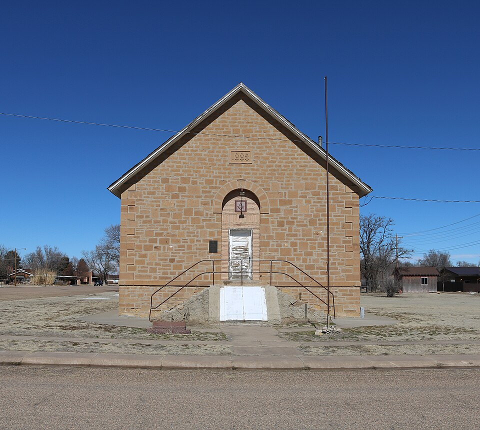
Listed on the National Register of Historic Places in 1977.
One of 3 National Register listings published here for Baca County · listed in 1977 · category: Building.
Sources: the case file at the National Archives · the National Register database, National Park Service · the Wikipedia article
Regional context, not property-specific evidence. The federal wildfire occurrence database lists 52 fires within 5 miles of Springfield Schoolhouse between 1992 and 2018, burning about 671 acres in total. 5 started naturally. 1 was recorded as arson. Distance is straight-line from the map coordinates, so a fire counted here may appear on a neighbouring settlement's page as well.
| Reported cause | Fires |
|---|---|
| Missing data/not specified/undetermined | 32 |
| Recreation and ceremony | 6 |
| Natural | 5 |
| Debris and open burning | 3 |
| Equipment and vehicle use | 3 |
| Power generation/transmission/distribution | 1 |
| Misuse of fire by a minor | 1 |
| Arson/incendiarism | 1 |
The most recent of them, most recent first, with the day each was reported and the service that recorded it.
| Date | Cause | Size | Reported by | Name on the report |
|---|---|---|---|---|
| 31 August 2010 | Missing data/not specified/undetermined | 20 acres | Colorado State Forest Service-State Headquarters | not named |
| 30 August 2014 | Equipment and vehicle use | under an acre | Springfield Fire Department | UNKNOWN |
| 3 August 2010 | Missing data/not specified/undetermined | under an acre | Colorado State Forest Service-State Headquarters | not named |
| 26 August 2003 | Missing data/not specified/undetermined | under an acre | Colorado State Forest Service-State Headquarters | not named |
| 22 August 2010 | Missing data/not specified/undetermined | under an acre | Colorado State Forest Service-State Headquarters | not named |
| 22 August 1995 | Equipment and vehicle use | under an acre | Park County | not named |
| 18 August 2010 | Missing data/not specified/undetermined | 2.0 acres | Colorado State Forest Service-State Headquarters | not named |
| 24 July 2005 | Natural | 2.0 acres | Pike and San Isabel National Forest | ALPHA |
Regional context, not property-specific evidence. The National Weather Service names Springfield, the town this property stands in, in 135 storm reports between 1995 and 2025: 104 hail, 14 thunderstorm wind, 11 tornado, 3 funnel cloud. No death or injury is recorded in these reports. Each account below is quoted exactly as the forecast office filed it, from the NOAA Storm Events Database, and each date opens the federal record of that event.
| When | Event | Place named | Harm | What the report says |
|---|---|---|---|---|
| May 2010 | Hail | Springfield | $250,000 | Damaging large hail occurred in Springfield and north-northwest of town over a half hour time frame. |
| May 2003 | Tornado (F2) | Springfield | $125,000 | A tornado moved northeast across a rural area, but did strike the county gravel pit and a few ranches. Approximately 1 1/2 miles of utility poles were brought down by the tornado and rear flank downdraft along U.S. Highway 160. At the gravel pit north of the highway, gravel screening machinery sustained heavy damage. Farther to the northeast a sheet metal building with a steel girder frame was a total loss. |
| September 2004 | Hail | Springfield | $100,000 | Hail occurred for nearly an hour, ranging from one inch to 1.75 inches in diameter. |
| August 2008 | Thunderstorm Wind | Springfield | $50,000 | Several airport hangars were destroyed and a few planes were damaged at the Springfield Airport due to a powerful microburst. |
| June 2015 | Thunderstorm Wind | Springfield | $20,000 | Damaging winds occurred in Springfield, of note, at the Fairgrounds and High School. |
| June 2015 | Thunderstorm Wind | Springfield | $15,000 | Damaging winds knocked down 10 power poles along Highway 160. |
| May 2010 | Tornado (EF1) | Springfield | $9,000 | A tornado traveled north-northwest for approximately 8 miles, moving a hay swather, and taking down five power poles. |
| July 2015 | Thunderstorm Wind | Springfield | $1,000 | High winds downed many tree branches, some up to 6 inches in diameter, and caused minor damage to a house. |
| September 2025 | Hail | Springfield | - | Hail up to 1.75 inches was measured in north central Baca County. |
| July 2024 | Thunderstorm Wind | Springfield | - | Downed power poles along of 287 north of mm 46. |
| September 2024 | Thunderstorm Wind | Springfield | - | There was a 50 knot wind gust reported at location. |
| June 2023 | Hail | Springfield | - | CoCoRaHS observer reported the 4 inch hail stone. |
| June 2023 | Hail | Springfield | - | Emergency Manager reported hail. |
| June 2023 | Hail | Springfield | - | The hail stone was a little under 4 inches. |
| June 2023 | Hail | Springfield | - | Storm chaser reported. |
| August 2020 | Thunderstorm Wind | Springfield | - | Three power poles damaged and one blown down. |
| August 2020 | Hail | Springfield | - | Trained spotter reported large hail, the size of 1.75 inches. |
| May 2019 | Hail | Springfield | - | Large hail reported just north of Springfield, CO during a severe thunderstorm. |
| May 2019 | Hail | Springfield | - | Large hail reported by a storm chaser outside of Springfield, CO. |
| May 2019 | Hail | Springfield | - | Large hail reported by storm chaser north of Springfield, CO. |
| May 2019 | Hail | Springfield | - | Large hail reported by the public north of Springfield, CO. |
| May 2019 | Hail | Springfield | - | Large hail reported by storm chaser north of Springfield, CO. |
| May 2019 | Hail | Springfield | - | Large hail and minor street flooding reported by trained SKYWARN spotter in Springfield, CO. |
| May 2019 | Hail | Springfield | - | Large hail report relayed by TV media north of Springfield, CO. |
| July 2014 | Flash Flood | Springfield | - | Strong storms produced heavy rain and flash flooding. Numerous roads and city streets were flooded. |
| June 2014 | Tornado (EF0) | Springfield | - | A brief landspout tornado occurred over open country with no damage. |
| June 2012 | Thunderstorm Wind | Springfield | - | Blowing dust reduced visibility to near zero...no damage reported. |
| June 2004 | Tornado (F0) | Springfield | - | A brief tornado occurred over open country with no known damage. |
| June 2004 | Tornado (F0) | Springfield | - | A brief tornado occurred over open country with no known damage. |
| June 2004 | Tornado (F0) | Springfield | - | A brief tornado occurred over open country with no known damage. |
| June 2004 | Tornado (F0) | Springfield | - | A tornado occurred over open country with no known damage. |
| July 2002 | Flash Flood | Springfield | - | Very heavy rainfall in excess of six inches caused some flooding of county roads and low areas in the Sand arroyo basin. |
| May 2001 | Thunderstorm Wind | Springfield | - | An extremely strong cold front moved rapidly south across the southeast plains during the evening of the 20th. Temperatures were in the 70s to lower 80s before the front moved through and quickly dropped into the 40s and 50s. By late evening temperatures had dropped into the 30s with light snow. Up to two inches of snow accumulated in northern El Paso county around Monument and in the Rye area of western Pueblo county. The front was accompanied by strong gradient winds. Causing more problems was the line of showers and thunderstorms that accompanied the front. Widespread severe thunderstorm winds occurred, gusting from 60 to 86 mph. Power failures and downed trees and tree limbs, too numerous to mention individually, were reported across southeast Colorado. Around 100 boats were out on the Pueblo Reservoir when the north winds hit. There were numerous water rescues by park rangers, despite the fact that one of their boats capsized and was lost. Numerous people were treated for minor hypothermia, a result of being thrown into the cool water. Damage was done to the boat docks at the two marinas. Damage estimates for the area were somewhat rough at the time this report was submitted. |
| July 2000 | Tornado (F0) | Springfield | - | A small, shortlived landspout tornado caused no known damage over open country of northwest Baca county. |
| August 1997 | Flash Flood | Springfield | - | Slow moving thunderstorms producing heavy rain totals of two to four inches flooded county roads north of Springfield early in the afternoon. |
| July 2023 | Hail | Springfield | - | no account filed |
| June 2018 | Hail | Springfield | - | no account filed |
| June 2017 | Hail | Springfield | - | no account filed |
| July 2016 | Hail | Springfield | - | no account filed |
| July 2016 | Hail | Springfield | - | no account filed |
| July 2016 | Hail | Springfield | - | no account filed |
| July 2016 | Hail | Springfield | - | no account filed |
| July 2016 | Hail | Springfield | - | no account filed |
| June 2015 | Hail | Springfield | - | no account filed |
| June 2015 | Hail | Springfield | - | no account filed |
| August 2015 | Hail | Springfield | - | no account filed |
| June 2015 | Hail | Springfield | - | no account filed |
| April 2015 | Hail | Springfield | - | no account filed |
| May 2015 | Funnel Cloud | Springfield | - | no account filed |
| August 2014 | Hail | Springfield | - | no account filed |
| June 2012 | Hail | Springfield | - | no account filed |
| April 2012 | Hail | Springfield | - | no account filed |
| April 2010 | Hail | Springfield | - | no account filed |
| May 2010 | Hail | Springfield | - | no account filed |
| May 2010 | Hail | Springfield | - | no account filed |
| May 2010 | Hail | Springfield | - | no account filed |
| May 2010 | Hail | Springfield | - | no account filed |
| June 2010 | Hail | Springfield | - | no account filed |
| June 2010 | Hail | Springfield | - | no account filed |
| June 2010 | Hail | Springfield | - | no account filed |
No historic map-sheet match is published for this property yet. That does not mean no map exists. This record needs a coordinate-quality review before it can be joined to a sheet boundary. Browse the county's mapped places while that work is pending.
| National Archives record | The nomination case file for reference 77000363 in Record Group 79. |
| Wikipedia article | Community-written account of this property, licensed CC BY-SA. |
| Baca County | All 3 listed properties in this county. |