 Block
From the record
4 National Register listings published here.
Sources: the National Register database, National Park Service
65 topographic sheets cover 12 settlements here, and 4 properties are on the National Register of Historic Places.
4 National Register listings published here.
Sources: the National Register database, National Park Service
Every property in this county listed on the National Register of Historic Places, with the year it was listed and the federal nomination document.
| Photograph | Property | Type | Listed | Reference |
|---|---|---|---|---|
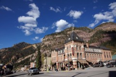 | Beaumont Hotel | building | 1973 | 73000483 |
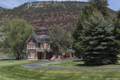 | George Jackson House | building | 1996 | 95001508 |
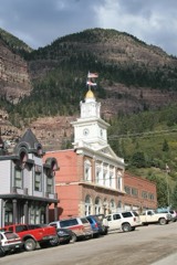 | Ouray City Hall and Walsh Library | building | 1975 | 75000528 |
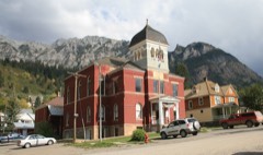 | Ouray Historic District | district | 1983 | 83003537 |
Every wildfire the federal occurrence database records inside this county: 202 of them, burning about 1,488 acres. 115 started naturally and 1 was recorded as arson. Each settlement page carries the fires within five miles of it.
| Reported cause | Fires |
|---|---|
| Natural | 115 |
| Missing data/not specified/undetermined | 44 |
| Recreation and ceremony | 28 |
| Debris and open burning | 5 |
| Power generation/transmission/distribution | 4 |
| Smoking | 3 |
| Equipment and vehicle use | 2 |
| Arson/incendiarism | 1 |
The five largest, by the area the report gives. None of them was recorded as arson.
| Date | Cause | Size | Reported by | Name on the report |
|---|---|---|---|---|
| 16 October 2019 | Missing data/not specified/undetermined | 859 acres | Grand Mesa, Uncompahgre and Gunnison National Forests | COW CREEK |
| 28 June 2006 | Natural | 401 acres | Grand Mesa, Uncompahgre and Gunnison National Forests | RED CREEK |
| 3 July 2004 | Natural | 83 acres | Southwest District, Montrose | TAPPAN |
| 21 October 1995 | Smoking | 40 acres | Grand Mesa, Uncompahgre and Gunnison National Forests | SNEVA MOUNTAIN |
| 11 June 1996 | Natural | 20 acres | Southwest District, Montrose | BILLY CRK |
| 3 July 1994 | Natural | 20 acres | Southwest District, Montrose | DAVE WOOD |
| 30 July 2000 | Natural | 6.0 acres | Grand Mesa, Uncompahgre and Gunnison National Forests | CORBETT |
| 10 March 2005 | Missing data/not specified/undetermined | 6.0 acres | Colorado State Forest Service-State Headquarters | not named |
Every settlement page carries the fires within five miles of it - see the settlement index below.
The NOAA Storm Events Database holds 53 reports for this county, causing 1 death, no injuries and about $2,220,000 in recorded property damage. Each settlement page carries the reports that name it.
| Kind of event | Reports |
|---|---|
| Flash Flood | 19 |
| Debris Flow | 17 |
| Heavy Rain | 8 |
| Hail | 3 |
| Flood | 3 |
| Lightning | 2 |
| Thunderstorm Wind | 1 |
The most serious of them, by death, then injury, then recorded damage. The accounts are quoted exactly as the forecast office filed them.
| When | Event | Place named | Harm | What the report says |
|---|---|---|---|---|
| June 1996 | Lightning | Telluride | 1 killed | no account filed |
| July 1999 | Flash Flood | Ridgway | $1,250,000 | no account filed |
| July 2018 | Debris Flow | Ouray | $500,000 | Around 4 to 10 feet of mud and rock covered Colorado Highway 550 about 2 miles south of Ouray as a result of heavy rainfall. A section of the highway and cribwall that supports the highway were destroyed from the rock slides and debris flows that occurred. Highway 550 was closed for almost 24 hours until the debris was removed, and then the highway was limited to one lane for many weeks thereafter as the road was repaired. |
| July 2010 | Flash Flood | Ouray | $100,000 | Heavy rainfall caused flash flooding in the area of Dexter Creek and Skyrocket Creek north of Ouray, as well as along Cascade Creek in Ouray. In some sections of Dexter Creek, the flash flood waters were nearly 20 feet deep. A section of road was washed out and the remaining buildings from the abandoned Old Maid Mine and town, built in the late 1800s, were completely obliterated with only some foundations remaining. An enormous amount of debris flowed through and collected in sections of Dexter Creek, which is the main water source for many residents in Ouray County. In particular, log jams and boulders the size of large trucks clogged a quarter-mile section of Dexter Creek, filling the creek up to 20 feet deep from the original creek bed elevation. Skyrocket Creek flowed up to a foot deep across Highway 550 as the highway culvert was filled beyond capacity. A motel on the west side of the highway experienced flooding in the parking lot and to some lower level motel rooms. Skyrocket Creek deposited about 8000 cubic yards of debris, mostly rocks and boulders, in a catch basin just above the Uncompahgre River. About 2000 cubic yards of debris filled up a catch basin near Highway 550 just before Cascade Creek dumps into the Uncompahgre River. The Uncompahgre River gage near Ridgway measured a stage jump of nearly 2 feet that evening due to the upstream inflow from the flooding creeks. Radar storm total rainfall estimates over the mountains near Ouray ranged from 1.5 to 1.75 inches, most of which fell within 60 minutes. |
| August 2008 | Flash Flood | Ouray | $80,000 | A flash flood came down Corbett Creek leaving a debris fan several hundred yards long, 300 feet wide and five feet deep. A house on Whispering Pines Drive sustained extensive damage to the foundation and exterior, with the deck having been ripped off. Another house on Chipmunk Way had debris up to a half foot deep into the basement and garage, and a deposit of debris up to 2 feet deep on the deck and against the house. A family of hikers on the Dallas Trail became stranded when their parked car was washed away. Their car was a total loss. Another car was carried away from a driveway and dropped over a short cliff. A boulder the size of a small car fell onto nearby Highway 550. County Road 17 was washed out and another nearby private road was washed out in places. The flash flood resulted in Corbett Creek carving out a new channel. A local official said this was the worst flash flood he had seen in that area since 1991. |
| May 2013 | Thunderstorm Wind | Colona | $60,000 | A mobile home was rolled a few times and destroyed by severe thunderstorm outflow winds. A pole barn also lost part of it's roof. No injuries were reported. |
| July 2017 | Flash Flood | Campbird | $50,000 | Heavy rainfall resulted in flash flooding and mudslides southwest of the town of Ouray. The costliest flash flood in the impacted area tore up a section of County Road 361 where new construction had just been completed. The crib wall, culverts, and other cement road structures were damaged beyond repair. Additionally, several culverts along County Road 361 became clogged by debris. Flash flooding with tons of debris deposits also occurred further down on Yankee Boy Road where 26 mudslides occurred. Additional mudslides and flooding also came down across Corkscrew Road. Radar estimated rainfall was between 0.50 to 1.00 inches at the time. |
| July 1999 | Flash Flood | Ouray | $50,000 | no account filed |
| July 1998 | Flash Flood | Ouray | $20,000 | no account filed |
| August 2005 | Flash Flood | Ouray | $15,000 | no account filed |
| August 2005 | Flash Flood | Ouray | $15,000 | no account filed |
| August 2003 | Flash Flood | Ouray | $15,000 | no account filed |
| July 2022 | Debris Flow | Campbird | $10,000 | Heavy rain from thunderstorms resulted in flash flooding and a debris flow across County Road 361, specifically in the Senator Gulch/Yankee Boy Basin area. Ouray County Road and Bridge reported a critical Hilfiker wall and culvert were significantly damaged as a result of the mudslide. Approximately 50 people were unable to leave the Yankee Boy Basin area until the debris was cleared. |
| August 2023 | Debris Flow | Portland | $7,500 | Mud and debris flowed across County Road 17 at Corbett Creek near the Dallas Trailhead as a result of heavy rain from thunderstorms. The road remained closed through the end of the month. |
| August 2023 | Debris Flow | Campbird | $5,000 | Heavy rain from thunderstorms resulted in a debris flow in the Yankee Boy Basin area. |
| July 2022 | Debris Flow | Red Mtn | $5,000 | A mudslide occurred along Colorado Highway 550 on Red Mountain Pass near Ironton as a result of heavy rain. The Department of Transportation reported approximately 3 feet of mud and debris including dead trees, limbs and boulders on the road. |
| July 2022 | Debris Flow | Portland | $5,000 | Mud and debris flowed across County Road 17 at Corbett Creek near the Dallas Trailhead as a result of heavy rain from thunderstorms. The Corbett Creek culvert was completely plugged. The road was closed for several hours due to cleanup operations. |
| August 2022 | Debris Flow | Portland | $5,000 | Mud and debris flowed across County Road 17 at Corbett Creek near the Dallas Trailhead as a result of heavy rain from thunderstorms. |
| July 2021 | Debris Flow | Campbird | $5,000 | A mudslide and flooding occurred on Red Mountain Pass as a result of heavy rains. Colorado Highway 550 was closed in both directions at the pass for a couple of hours due to cleanup operations. |
| July 2021 | Debris Flow | Red Mtn | $5,000 | A mudslide occurred as a result of heavy rains across Colorado Highway 550 near Ironton (mile marker 85). The mudslide covered both directions of the highway. |
| August 2000 | Flash Flood | Ridgway | $5,000 | no account filed |
| July 2008 | Flash Flood | Ouray | $4,000 | Heavy rain on the mountains adjacent to the southeast part of the town of Ouray produced flash flooding on Oak Creek and Canyon Creek. The wall of water was six feet deep at the Box Canyon geothermal water plant where sediment got into the water line. Sediment carried by the water line was in inch deep at the Ouray Hot Springs. The Hot Springs had to be closed around 4 PM MDT and remained closed for the rest of that day to clean out the sediment. Six feet of South Pinecrest Road was washed out, and a culvert under that road was damaged. Debris up to a foot-and-a-half deep was deposited on other roads. |
| August 2022 | Debris Flow | Portland | $2,500 | Mud and debris flowed across County Road 17 at Corbett Creek near the Dallas Trailhead as a result of heavy rain from thunderstorms. |
| July 2022 | Flash Flood | Ridgway | $1,000 | Ouray County Sheriff's Office reported 3 feet of running water on County Road 24 and 24A as a result of heavy rain from thunderstorms and runoff. |
| July 2022 | Flood | Portland | $1,000 | The Cedar Hill Cemetery outside of Ridgway experienced flooding as a result of heavy rain from thunderstorms. |
| July 2022 | Debris Flow | Campbird | $1,000 | A mud and rockslide occurred on the east side of Imogene Pass as a result of heavy rain from thunderstorms. The road was closed for a period for cleanup operations. |
| August 1999 | Lightning | Ouray | $1,000 | no account filed |
| August 1999 | Flash Flood | Ouray | $1,000 | no account filed |
| July 1998 | Flash Flood | Ouray | $1,000 | no account filed |
| August 2024 | Debris Flow | Ouray | - | Heavy rain from thunderstorms in Ouray caused town flooding as well as the flooding of several creeks including Oak, Cascade and Skyrocket Creek. These creeks filled with debris, rock and silt, resulting in trail closures and large boulders/rock slides and mudslides on Highway 550 at mile marker 94, 94.5 and 94.6 specifically but generally between mile markers 94 and 95 approximately 2 miles north-northwest of Ouray. Storm total rainfall ranged from 1.5 to 1.7 inches in Ouray. Daily spot forecasts were requested by emergency management for both Ridgway and Ouray for extensive cleanup efforts for several days following the debris flows. |
| August 2024 | Debris Flow | Ridgway | - | Heavy rainfall resulted in mudslides along Highway 550 at mile marker 101.5, approximately 2 miles south-southeast of Ridgway. About an inch of storm total rainfall was reported in Ridgway with this event. Daily spot forecasts were requested by emergency management for both Ridgway and Ouray for extensive cleanup efforts for several days following the debris flows. |
| July 2020 | Debris Flow | Campbird | - | A mudslide closed County Road 361, to Yankee Boy Basin, near Twin Falls as a result of heavy rain. |
| July 2020 | Debris Flow | Red Mtn | - | Several mudslides occurred along Colorado Highway 550 as a result of heavy rain. One was reported at mile marker 83 which led to a partial closure for southbound traffic as the debris was cleared. Both Black Bear and Imogene Passes also closed on the Telluride side due to the debris flows. |
| August 2014 | Debris Flow | Portland | - | Highway 550 was closed due to a debris flow at mile marker 100 in the Uncompahgre River valley near Portland. Mud, trees and tires all flowed across both lanes of the roadway. |
| August 2013 | Flash Flood | Portland | - | Heavy rainfall along the Canyon Creek drainage area forced water and debris a foot deep over County Road 17 near Ouray. |
| August 2013 | Flash Flood | Ouray | - | Oak Creek and Canyon Creek experienced flash floods due to heavy runoff runoff from nearby mountains. Roads on the west side of Ouray were impassable due to the rising and fast moving water. |
| September 2013 | Heavy Rain | Ouray | - | A storm spotter in the town of Ouray received 0.7 inches of rain within one hour. The heavy rainfall caused minor street flooding. |
| September 2013 | Debris Flow | Ouray | - | Heavy rainfall caused mud and debris flows in Senator Gulch past Angle Creek. |
| July 2012 | Heavy Rain | Ouray | - | Heavy rainfall in excess of one inch fell during the early evening hours in Ouray. |
| August 2011 | Flash Flood | Red Mtn | - | Flash floods deposited 1 to 2 feet of mud, rocks, and other debris onto Highway 550 on the north side of Red Mountain Pass. Highway 550 was closed until crews were able to clear the road. |
| July 2010 | Heavy Rain | Ouray | - | Heavy rain fell over the mountains on the east side of Ouray, resulting in minor flooding. The flood control flumes contained the heavy runoff. Radar storm total precipitation estimates over the mountains adjacent to Ouray ranged from 1.5 to 1.75 inches within a 90 minute period. The Uncompahgre River near Ridgway had a rapid stage increase of 1.2 feet due to the large inflow of water from the creeks in the Ouray area. |
| June 2009 | Heavy Rain | Ridgway | - | Heavy rainfall totaling 0.82 of an inch fell within about an hour resulting in minor street flooding. |
| August 2006 | Heavy Rain | Ouray | - | no account filed |
| July 2006 | Hail | Ouray | - | no account filed |
| July 2006 | Heavy Rain | Ridgway | - | no account filed |
| August 2005 | Heavy Rain | Ridgway | - | no account filed |
| July 2004 | Heavy Rain | Ouray | - | no account filed |
| August 2003 | Flash Flood | Ouray | - | no account filed |
| July 2002 | Flash Flood | Ouray | - | no account filed |
| July 2001 | Hail | Ridgway | - | no account filed |
| July 2001 | Flood | Ridgway | - | no account filed |
| July 2001 | Flood | Ridgway | - | no account filed |
| July 2000 | Hail | Ridgway | - | no account filed |
The Survey's mineral resources record lists 264 workings inside this county. 13 still produce and 251 are closed or unrecorded. Each settlement page carries the workings within five miles of it.
| Commodity | Workings |
|---|---|
| Gold | 130 |
| Silver | 110 |
| Lead | 39 |
| Lead, Silver | 38 |
| Lead, Zinc | 30 |
| Zinc | 28 |
| Zinc, Lead | 16 |
| Silver, Lead | 13 |
| Sand and Gravel, Construction | 6 |
| Copper, Lead, Silver, Zinc | 6 |
| Copper | 6 |
| Molybdenum | 5 |
| Manganese | 4 |
| Lead, Silver, Zinc | 4 |
The least common of them first, because a county's hundredth gravel pit says nothing its first ten did not.
| Where | Site | Commodity | Status | Recorded |
|---|---|---|---|---|
| American-Nettie | Gold, Copper, Zinc, Silver, Lead | Past Producer | Galena, Pyrargyrite | |
| Bachelor Mine | Silver, Copper, Zinc, Lead, Gold | Past Producer | Galena, Sphalerite, Tetrahedrite | |
| Bay City Mill | Gold, Lead, Silver, Zinc, Copper | Past Producer | ||
| Camp Bird Mine | Copper, Gold, Lead, Silver, Zinc | Past Producer | 1896, 1900 | |
| Cora Belle | Lead, Gold, Copper, Silver | Past Producer | Pyrite | |
| Hawkeye Claims | Gold, Silver | Producer | Chalcopyrite | |
| Hoffy | Gold, Zinc, Silver, Lead | Unknown | ||
| Idarado Mine | Lead, Silver, Copper, Gold, Zinc | Past Producer | 1870, 1875 | |
| Ironton Park Bog Iron | Iron | Past Producer | ||
| Keno - Patsie Et Al Claims | Silver, Lead, Copper | Producer | Argentite, Chalcopyrite, Galena | |
| Laura Dunmore | Gold, Lead, Zinc, Uranium, Silver | Occurrence | Vein | |
| Lucky Twenty Mine | Zinc, Lead, Gold, Silver | Past Producer | Galena, Pyrite, Sphalerite | |
| Monarch | Silver, Copper, Gold, Zinc, Lead | Past Producer | ||
| National Belle Mine | Aluminum, Copper, Silver | Past Producer | ||
| Ouray | Silver, Gold, Zinc, Platinum, Osmium, Palladium, Iridium | Occurrence | Stream Placer | |
| Patsie Helen and Marion | Silver, Gold, Rhenium | Occurrence | Chalcopyrite, Galena, Pyrite | |
| Pony Express Mine | Barium-Barite, Gold, Lead, Silver, Zinc | Past Producer | ||
| Quarry | Stone | Producer | ||
| Red Mountain Deposits | Silver, Lead, Gold, Copper, Zinc, Tin | Past Producer | 1883, 1884 | |
| Revenue-Virginius Mine | Silver, Gold, Arsenic, Zinc, Lead, Copper | Producer | 1876 | |
| Rouville | Gold, Copper, Lead, Zinc, Silver | Past Producer | ||
| San Antonio | Lead, Zinc, Copper, Gold, Silver | Past Producer | ||
| Sneffels - Red Mountain District | Copper, Lead, Gold, Zinc, Silver | Past Producer | HYDROTHERMAL STOCK, MASSIVE (CHIMNEY DEPOSIT), HYDROTHERMAL VEIN | |
| Terrible | Gold, Lead, Silver, Copper | Past Producer | ||
| The Blowout | Molybdenum, Copper | Occurrence | Molybdenite | |
| Torpedo Eclipse Mine | Manganese, Fluorine-Fluorite | Past Producer | Fluorite, Pyrolusite | |
| Treasure Trove | Zinc, Lead, Uranium, Copper, Vanadium | Past Producer | Enargite, Galena | |
| Treasury Tunnel | Lead, Zinc, Copper, Silver, Gold | Past Producer | ||
| Uncle Sam | Gold, Zinc, Copper, Lead, Silver | Past Producer | ||
| Uncompahgre District | Zinc, Gold, Copper, Lead, Silver, Barium-Barite, Antimony | Past Producer | 1874 | |
| Unknown | Lead, Gold, Silver, Zinc | Past Producer | ||
| Unknown | Lead, Zinc, Copper | Past Producer | ||
| Unknown | Lead, Silver, Copper | Past Producer | ||
| Wewissa Mine | Silver, Lead, Zinc | Producer | Galena, Sphalerite, Tetrahedrite | |
| Barstow Mine | Fluorine-Fluorite, Copper, Silver | Past Producer | ||
| Black Diamond and Altuna | Lead, Uranium | Past Producer | ||
| Fortuna | Lead, Copper, Zinc | Past Producer | ||
| Gold King | Lead, Copper, Zinc | Past Producer | ||
| Michael Breen Mine | Fluorine-Fluorite, Copper, Lead, Silver, Zinc | Past Producer | ||
| Mineral Farm Mine | Barium-Barite | Past Producer | ||
| Orvis Hot Spring | Geothermal | Unknown | ||
| Ouray Hot Spring | Geothermal | Unknown | ||
| Robinson | Uranium | Past Producer | ||
| Unknown | Lead, Silver, Zinc | Past Producer | ||
| Unknown | Lead, Silver, Zinc | Past Producer | ||
| Atlas | Silver, Gold, Lead, Zinc | Past Producer | ||
| Bachelor Mill | Silver, Gold, Lead, Zinc | Past Producer | ||
| Dunmore | Tungsten | Past Producer | ||
| Elmer E Eggleston | Tungsten, Manganese | Past Producer | ||
| Mountain King | Silver, Gold, Lead, Zinc | Past Producer | ||
| Seniorita | Gold, Copper, Silver | Past Producer | ||
| Whippoorwill Mine | Manganese, Tungsten | Past Producer | ||
| Brown Mountain | Gold, Lead, Silver, Zinc | Past Producer | ||
| Genessee-Vanderbilt | Copper, Lead, Silver, Zinc | Past Producer | ||
| Greyhound Group | Gold, Lead, Silver, Zinc | Past Producer | ||
| Patsy-Lost Day | Gold, Lead, Silver, Zinc | Unknown | ||
| Sutton and Weatherly Claims | Manganese | Prospect | 1919 | |
| Unknown | Manganese | Past Producer | ||
| Irene | Molybdenum | Occurrence | Molybdenite | |
| Mammoth Mine | Molybdenum | Unknown | ||
| Molly | Molybdenum | Unknown | ||
| Unknown | Molybdenum | Past Producer | ||
| Unknown | Molybdenum | Past Producer | ||
| Beaver/Belfast | Gold, Copper, Lead, Silver, Zinc | Past Producer | ||
| Camp Bird Mill | Gold, Copper, Lead, Silver, Zinc | Past Producer | ||
| Gravel Pit | Sand and Gravel, Construction | Producer | ||
| Gravel Pit | Sand and Gravel, Construction | Producer | ||
| Gravel Pit | Sand and Gravel, Construction | Producer | ||
| Gravel Pit | Sand and Gravel, Construction | Producer | ||
| Gravel Pit | Sand and Gravel, Construction | Producer | ||
| Gravel Pit | Sand and Gravel, Construction | Producer | ||
| Guston #5 | Copper, Silver | Past Producer | ||
| Hidden Treasure | Gold, Copper, Lead, Silver, Zinc | Past Producer | ||
| Kentucky Giant | Copper, Silver | Past Producer | ||
| Kerr-Ouray #2 | Copper, Zinc, Lead | Past Producer | ||
| News Boy | Copper, Silver | Past Producer | ||
| South Dakota | Gold, Copper, Lead, Silver, Zinc | Past Producer | ||
| Virginius | Gold, Copper, Lead, Silver, Zinc | Past Producer | ||
| Yankee Girl Shaft | Copper, Silver | Past Producer | ||
| Keno | Gold, Silver, Lead | Past Producer | ||
| Silver King | Gold, Silver, Lead | Past Producer | ||
| Sunrise Tunnel | Gold, Silver, Lead | Past Producer | ||
| Unknown | Gold, Silver, Lead | Past Producer | ||
| Unknown | Gold, Silver, Lead | Past Producer | ||
| Unknown | Gold, Silver, Lead | Past Producer | ||
| Unknown | Gold, Silver, Lead | Past Producer | ||
| Unknown | Gold, Silver, Lead | Past Producer | ||
| Unknown | Gold, Silver, Lead | Past Producer | ||
| Unknown | Gold, Silver, Lead | Past Producer | ||
| Unknown | Gold, Silver, Lead | Past Producer | ||
| Unknown | Gold, Silver, Lead | Past Producer | ||
| Wheel of Fortune | Gold, Silver, Lead | Past Producer | ||
| Unknown | Silver, Zinc, Lead | Past Producer | ||
| Unknown | Silver, Zinc, Lead | Past Producer | ||
| Unknown | Silver, Zinc, Lead | Past Producer | ||
| Unknown | Silver, Zinc, Lead | Past Producer | ||
| Unknown | Silver, Zinc, Lead | Past Producer | ||
| Unknown | Silver, Zinc, Lead | Past Producer | ||
| Unknown | Silver, Zinc, Lead | Past Producer | ||
| Unknown | Silver, Zinc, Lead | Past Producer | ||
| Unknown | Silver, Zinc, Lead | Past Producer | ||
| Unknown | Silver, Zinc, Lead | Past Producer | ||
| Unknown | Silver, Zinc, Lead | Past Producer | ||
| Unknown | Silver, Zinc, Lead | Past Producer | ||
| Unknown | Silver, Zinc, Lead | Past Producer | ||
| Unknown | Silver, Zinc, Lead | Past Producer | ||
| Unknown | Silver, Zinc, Lead | Past Producer | ||
| (Facility) Saratoga Smelter | Lead, Zinc | Plant | ||
| Amador | Lead, Zinc | Past Producer | ||
| American Lead/Zinc Mill | Lead, Zinc | Past Producer | ||
| Chief Ouray Mine | Lead, Zinc | Past Producer | ||
| Fullmer | Lead, Zinc | Past Producer | ||
| Jack Pot | Lead, Zinc | Past Producer | ||
| Keystone Mine | Lead, Zinc | Past Producer | ||
| North Star & Conny | Lead, Zinc | Unknown | ||
| Ocean Wave | Lead, Zinc | Past Producer | ||
| Old Maid Mine | Lead, Zinc | Past Producer | ||
| Pittsburgh | Lead, Zinc | Unknown | ||
| Prince Lode Claims | Lead, Zinc | Past Producer | ||
| R E Lee Claim,Atlantic C | Lead, Zinc | Past Producer | ||
| Red Creek Mine | Lead, Zinc | Past Producer | ||
| Rock of the Ages Mine | Lead, Zinc | Past Producer | ||
| Saratoga | Lead, Zinc | Past Producer | ||
| Sequin Mine | Lead, Zinc | Past Producer | ||
| Sieberg | Lead, Zinc | Past Producer | ||
| Silvershield Mill | Lead, Zinc | Past Producer | ||
| Speedwell | Lead, Zinc | Past Producer | ||
| Unknown | Lead, Zinc | Past Producer | ||
| Unknown | Lead, Zinc | Past Producer | ||
| Wanakah | Lead, Zinc | Past Producer | ||
| Wedge | Lead, Zinc | Past Producer | ||
| West View | Lead, Zinc | Past Producer | ||
| Yellow Jacket Mine | Lead, Zinc | Past Producer | ||
| Nasby | Silver, Lead, Zinc | Past Producer | ||
| Neodesha | Silver, Lead, Zinc | Past Producer | ||
| Ruby Trust | Lead, Zinc | Producer | ||
| Sunshine | Silver, Lead, Zinc | Past Producer | ||
| Unknown | Silver, Lead, Zinc | Past Producer | ||
| Unknown | Silver, Lead, Zinc | Past Producer | ||
| Unknown | Silver, Lead, Zinc | Past Producer | ||
| Unknown | Silver, Lead, Zinc | Past Producer | ||
| Unknown | Silver, Lead, Zinc | Past Producer | ||
| Unknown | Silver, Lead, Zinc | Past Producer | ||
| Unknown | Silver, Lead, Zinc | Past Producer | ||
| Unknown | Silver, Lead, Zinc | Past Producer | ||
| Unknown | Silver, Lead, Zinc | Past Producer | ||
| Unknown | Silver, Lead, Zinc | Past Producer | ||
| Unknown | Silver, Lead, Zinc | Past Producer | ||
| Unknown | Silver, Lead, Zinc | Past Producer | ||
| Unknown | Silver, Lead, Zinc | Past Producer | ||
| Unknown | Silver, Lead, Zinc | Past Producer | ||
| Unknown | Silver, Lead, Zinc | Past Producer | ||
| Unknown | Silver, Lead, Zinc | Past Producer | ||
| Unknown | Silver, Lead, Zinc | Past Producer | ||
| Unknown | Silver, Lead, Zinc | Past Producer | ||
| Unknown | Silver, Lead, Zinc | Past Producer | ||
| Unknown | Silver, Lead, Zinc | Past Producer | ||
| Unknown | Silver, Lead, Zinc | Past Producer | ||
| Unknown | Silver, Lead, Zinc | Past Producer | ||
| Unknown | Silver, Lead, Zinc | Past Producer | ||
| Unknown | Silver, Lead, Zinc | Past Producer | ||
| Unknown | Silver, Lead, Zinc | Past Producer | ||
| Boston Sunday | Gold, Lead, Silver | Past Producer | ||
| Little Balm of Gilead | Gold, Lead, Silver | Past Producer | ||
| Silver Mountain Mine | Gold, Lead, Silver | Past Producer | ||
| St Lawerance | Gold, Lead, Silver | Past Producer | ||
| Sutton Mill | Gold, Lead, Silver | Past Producer | ||
| Sweepstakes | Gold, Lead, Silver | Past Producer | ||
| Tip Top | Gold, Lead, Silver | Past Producer | ||
| Unknown | Gold, Lead, Silver | Past Producer | ||
| Unknown | Gold, Lead, Silver | Past Producer | ||
| Unknown | Gold, Lead, Silver | Past Producer | ||
| Unknown | Gold, Lead, Silver | Past Producer | ||
| Unknown | Gold, Lead, Silver | Past Producer | ||
| Unknown | Gold, Lead, Silver | Past Producer | ||
| Unknown | Gold, Lead, Silver | Past Producer | ||
| Unknown | Gold, Lead, Silver | Past Producer | ||
| Unknown | Gold, Lead, Silver | Past Producer | ||
| Unknown | Gold, Lead, Silver | Past Producer | ||
| Unknown | Gold, Lead, Silver | Past Producer | ||
| Unknown | Gold, Lead, Silver | Past Producer | ||
| Unknown | Gold, Lead, Silver | Past Producer | ||
| Unknown | Gold, Lead, Silver | Past Producer | ||
| Unknown | Gold, Lead, Silver | Past Producer | ||
| Unknown | Gold, Lead, Silver | Past Producer | ||
| Unknown | Gold, Lead, Silver | Past Producer | ||
| Unknown | Gold, Lead, Silver | Past Producer | ||
| Unknown | Gold, Lead, Silver | Past Producer | ||
| Unknown | Gold, Lead, Silver | Past Producer | ||
| Unknown | Gold, Lead, Silver | Past Producer | ||
| Unknown | Gold, Lead, Silver | Past Producer | ||
| Unknown | Gold, Lead, Silver | Past Producer | ||
| Unknown | Gold, Lead, Silver | Past Producer | ||
| Unknown | Gold, Lead, Silver | Past Producer | ||
| Unknown | Gold, Lead, Silver | Past Producer | ||
| Unknown | Gold, Lead, Silver | Past Producer | ||
| Unknown | Gold, Lead, Silver | Past Producer | ||
| White Cloud | Gold, Lead, Silver | Past Producer | ||
| Yankee | Gold, Lead, Silver | Past Producer | ||
| Yellow Rose Mine | Gold, Lead, Silver | Past Producer | ||
| Alpine Mine | Gold, Lead | Past Producer | ||
| Mountain Top | Silver, Lead | Past Producer | ||
| Unknown | Gold, Lead | Past Producer | ||
| Albany | Gold, Silver | Past Producer | ||
| Alma | Gold, Silver | Past Producer | ||
| Bailey Shaft | Gold, Silver | Past Producer | ||
| Bankers Tunnel | Gold, Silver | Past Producer | ||
| Barhoff | Gold, Silver | Past Producer | ||
| Barstow #2 | Gold, Silver | Past Producer | ||
| Belle of the West | Gold, Silver | Past Producer | ||
| Bi-Metallist | Gold, Silver | Past Producer | ||
| Bismuth | Gold, Silver | Past Producer | ||
| Blaine | Gold, Silver | Unknown | ||
| Carbonate King | Gold, Silver | Past Producer | ||
| Charter Oak | Gold, Silver | Past Producer | ||
| Chipeta | Gold, Silver | Past Producer | ||
| Copper King | Gold, Silver | Past Producer | ||
| Donald | Gold, Silver | Past Producer | ||
| Dutton Gibson Lost Day | Gold, Silver | Past Producer | ||
| El Mahdi Almadi | Gold, Silver | Past Producer | ||
| Governer | Gold, Silver | Past Producer | ||
| Granger | Gold, Silver | Past Producer | ||
| Hero Mine | Gold, Silver | Past Producer | ||
| Humboldt | Gold, Silver | Past Producer | ||
| Imogene Tunnel | Gold, Silver | Past Producer | ||
| Joker Tunnel | Gold, Silver | Past Producer | ||
| Jonathan | Gold, Silver | Past Producer | ||
| Knox Shaft | Gold, Silver | Past Producer | ||
| Larson Bros Mine | Gold, Silver | Past Producer | ||
| Lost Day Mine | Gold, Silver | Past Producer | ||
| Lucky Twenty Mine | Gold, Silver | Past Producer | ||
| Magnolia Shaft | Gold, Silver | Past Producer | ||
| Meldrum Tunnel | Gold, Silver | Past Producer | ||
| Memphis | Gold, Silver | Past Producer | ||
| Midnight Mine | Gold, Silver | Past Producer | ||
| Monas Queen | Gold, Silver | Past Producer | ||
| Mountain Queen | Gold, Silver | Past Producer | ||
| Old Kentucky | Gold, Silver | Past Producer | ||
| Orphan Boy | Gold, Silver | Past Producer | ||
| Paymaster | Gold, Silver | Past Producer | ||
| Rainbow Tunnel | Gold, Silver | Past Producer | ||
| San Bernadino | Gold, Silver | Past Producer | ||
| San Pedro | Gold, Silver | Past Producer | ||
| Schofield | Gold, Silver | Past Producer | ||
| Silver Bell Mine | Gold, Silver | Past Producer | ||
| Topeka #1 | Gold, Silver | Past Producer | ||
| Topeka #2 | Gold, Silver | Past Producer | ||
| Unknown | Gold, Silver | Past Producer | ||
| Unknown | Gold, Silver | Past Producer | ||
| Unknown | Gold, Silver | Past Producer | ||
| Unknown | Gold, Silver | Past Producer | ||
| Unknown | Gold, Silver | Past Producer | ||
| Unknown | Gold, Silver | Past Producer | ||
| Unknown | Gold, Silver | Past Producer | ||
| Unknown | Gold, Silver | Past Producer | ||
| Unknown | Gold, Silver | Past Producer | ||
| Unknown | Gold, Silver | Past Producer | ||
| Unknown | Gold, Silver | Past Producer | ||
| Vanderbilt | Gold, Silver | Past Producer | ||
| Vernon Mine | Gold, Silver | Past Producer | ||
| Dallas Placers | Gold | Past Producer | ||
| Park Placer | Gold | Past Producer | ||
| Portland Mine | Gold | Past Producer | ||
| Syracuse Mine | Gold | Past Producer |
Named settlements recorded in the Geographic Names Information System, each with the topographic sheets covering it. Villages, hamlets and abandoned places alike. Each is shown with the nearest named watercourse or landform and the survey quadrangle it falls on.
Ouray census division · 81427 · On Sneffels Creek · Ironton quadrangle
28 sheets, 1897 to 1982
Ouray census division · 81427 · Near Champion Gulch · Ironton quadrangle
28 sheets, 1897 to 1982
No longer a settlement
Ouray census division · 81427 · Near Corkscrew Gulch · Ironton quadrangle
28 sheets, 1897 to 1982
Ouray census division · 81432 · Near Knife Edge · Ridgway quadrangle
16 sheets, 1909 to 1983
Ouray census division · 81432 · Near Potosi Peak · Ironton quadrangle
28 sheets, 1897 to 1982
No longer a settlement
Ouray census division · 81427 · On Weehawken Creek · Ironton quadrangle
28 sheets, 1897 to 1982
The vanished settlements of Ouray County: the places named above that are no longer on the map.