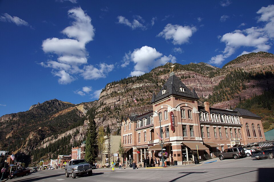
National Register reference number.73000483- the number the National Park Service assigned this property when it was listed, and the key its nomination file is catalogued under at the National Archives.
Fires near this property
24 since 1992
Regional context, not property-specific
evidence. The
federal wildfire occurrence database
lists 24 fires within 5 miles of Beaumont Hotel
between 1992 and 2020, burning about 10 acres in total. 15 started naturally. None was recorded as arson.
Distance is straight-line from the map coordinates, so a fire counted
here may appear on a neighbouring settlement's page as well.
Reported cause
Fires
Natural
15
Power generation/transmission/distribution
4
Recreation and ceremony
3
Missing data/not specified/undetermined
2
The most recent of
them, most recent first, with the day each was reported and the service
that recorded it.
Date
Cause
Size
Reported by
Name on the report
3 September 2004
Power generation/transmission/distribution
under an acre
Grand Mesa, Uncompahgre and Gunnison National Forests
ANGEL
8 August 2005
Recreation and ceremony
under an acre
Grand Mesa, Uncompahgre and Gunnison National Forests
ANGEL
28 August 1994
Natural
under an acre
Grand Mesa, Uncompahgre and Gunnison National Forests
not named
20 August 2020
Missing data/not specified/undetermined
under an acre
Grand Mesa, Uncompahgre and Gunnison National Forests
SILVER GULCH
11 August 1992
Natural
under an acre
Grand Mesa, Uncompahgre and Gunnison National Forests
not named
8 July 1997
Natural
under an acre
Grand Mesa, Uncompahgre and Gunnison National Forests
HORSETHIEF
7 July 2018
Natural
under an acre
Grand Mesa, Uncompahgre and Gunnison National Forests
HORSETHIEF
30 July 2000
Natural
6.0 acres
Grand Mesa, Uncompahgre and Gunnison National Forests
Regional context, not property-specific
evidence. The federal mineral resources record lists
98 workings within 5 miles of Beaumont Hotel: 89 past producers, 4 occurrences, 3 producers, 2 unknowns.
3 still produce. What was taken out: Silver, Gold, Lead, Zinc. Distance is straight-line from the
map coordinates, so a quarry counted here may appear on a neighbouring
settlement's page as well.
Regional context, not property-specific
evidence. The National Weather Service names
Ouray, the town this property stands in, in 23 storm reports between 1998 and 2024: 13 flash flood, 5 heavy rain, 3 debris flow, 1 lightning.
No death or injury is recorded in these reports. Each account below is quoted exactly as the forecast office
filed it, from the NOAA Storm Events Database, and each date
opens the federal record of that event.
Around 4 to 10 feet of mud and rock covered Colorado Highway 550 about 2 miles south of Ouray as a result of heavy rainfall. A section of the highway and cribwall that supports the highway were destroyed from the rock slides and debris flows that occurred. Highway 550 was closed for almost 24 hours until the debris was removed, and then the highway was limited to one lane for many weeks thereafter as the road was repaired.
Heavy rainfall caused flash flooding in the area of Dexter Creek and Skyrocket Creek north of Ouray, as well as along Cascade Creek in Ouray. In some sections of Dexter Creek, the flash flood waters were nearly 20 feet deep. A section of road was washed out and the remaining buildings from the abandoned Old Maid Mine and town, built in the late 1800s, were completely obliterated with only some foundations remaining. An enormous amount of debris flowed through and collected in sections of Dexter Creek, which is the main water source for many residents in Ouray County. In particular, log jams and boulders the size of large trucks clogged a quarter-mile section of Dexter Creek, filling the creek up to 20 feet deep from the original creek bed elevation. Skyrocket Creek flowed up to a foot deep across Highway 550 as the highway culvert was filled beyond capacity. A motel on the west side of the highway experienced flooding in the parking lot and to some lower level motel rooms. Skyrocket Creek deposited about 8000 cubic yards of debris, mostly rocks and boulders, in a catch basin just above the Uncompahgre River. About 2000 cubic yards of debris filled up a catch basin near Highway 550 just before Cascade Creek dumps into the Uncompahgre River. The Uncompahgre River gage near Ridgway measured a stage jump of nearly 2 feet that evening due to the upstream inflow from the flooding creeks. Radar storm total rainfall estimates over the mountains near Ouray ranged from 1.5 to 1.75 inches, most of which fell within 60 minutes.
A flash flood came down Corbett Creek leaving a debris fan several hundred yards long, 300 feet wide and five feet deep. A house on Whispering Pines Drive sustained extensive damage to the foundation and exterior, with the deck having been ripped off. Another house on Chipmunk Way had debris up to a half foot deep into the basement and garage, and a deposit of debris up to 2 feet deep on the deck and against the house. A family of hikers on the Dallas Trail became stranded when their parked car was washed away. Their car was a total loss. Another car was carried away from a driveway and dropped over a short cliff. A boulder the size of a small car fell onto nearby Highway 550. County Road 17 was washed out and another nearby private road was washed out in places. The flash flood resulted in Corbett Creek carving out a new channel. A local official said this was the worst flash flood he had seen in that area since 1991.
Heavy rain on the mountains adjacent to the southeast part of the town of Ouray produced flash flooding on Oak Creek and Canyon Creek. The wall of water was six feet deep at the Box Canyon geothermal water plant where sediment got into the water line. Sediment carried by the water line was in inch deep at the Ouray Hot Springs. The Hot Springs had to be closed around 4 PM MDT and remained closed for the rest of that day to clean out the sediment. Six feet of South Pinecrest Road was washed out, and a culvert under that road was damaged. Debris up to a foot-and-a-half deep was deposited on other roads.
Heavy rain from thunderstorms in Ouray caused town flooding as well as the flooding of several creeks including Oak, Cascade and Skyrocket Creek. These creeks filled with debris, rock and silt, resulting in trail closures and large boulders/rock slides and mudslides on Highway 550 at mile marker 94, 94.5 and 94.6 specifically but generally between mile markers 94 and 95 approximately 2 miles north-northwest of Ouray. Storm total rainfall ranged from 1.5 to 1.7 inches in Ouray. Daily spot forecasts were requested by emergency management for both Ridgway and Ouray for extensive cleanup efforts for several days following the debris flows.
Oak Creek and Canyon Creek experienced flash floods due to heavy runoff runoff from nearby mountains. Roads on the west side of Ouray were impassable due to the rising and fast moving water.
Heavy rain fell over the mountains on the east side of Ouray, resulting in minor flooding. The flood control flumes contained the heavy runoff. Radar storm total precipitation estimates over the mountains adjacent to Ouray ranged from 1.5 to 1.75 inches within a 90 minute period. The Uncompahgre River near Ridgway had a rapid stage increase of 1.2 feet due to the large inflow of water from the creeks in the Ouray area.
No historic map-sheet match is published
for this property yet. That does not mean no map exists. This record needs
a coordinate-quality review before it can be joined to a sheet boundary.
Browse the county's mapped places while that work is
pending.
Listed places nearby
3 within 8 miles
Other National Register properties close
enough to walk or drive between, ordered by distance from this one. Both
positions come from the same geocoding pass that matched these properties
to their map sheets.
Listing record. National Park Service National Register of Historic Places, listed-properties dataset, current to 2026-05-22.
Map join. Address geocoded through the United States Census geocoder, then tested against the published boundary of every sheet in the USGS Historical Topographic Map Collection.
How this page is made. Listing fields come from federal records; map-sheet coverage is a labelled coordinate-to-boundary calculation, not a source-field claim.
Wildfire. Short, Karen C. 2022. Spatial wildfire occurrence data for the United States, 1992-2020 [FPA_FOD_20221014]. 6th Edition. Fort Collins, CO: Forest Service Research Data Archive. https://doi.org/10.2737/RDS-2013-0009.6 Collected with United States Government funding and usable without additional permissions or fees.
Mines and quarries. USGS Mineral Resources Data System (MRDS) https://mrdata.usgs.gov/mrds/ A work of the United States government, no copyright under 17 U.S.C. 105.
Storms. NOAA National Centers for Environmental Information, Storm Events Database https://www.ncei.noaa.gov/stormevents/ A work of the United States government, no copyright under 17 U.S.C. 105. Narratives are quoted verbatim from the National Weather Service report and are not edited or summarised.
 Block