 Block
From the record
16 National Register listings published here, 1 of them a National Historic Landmark.
Sources: the National Register database, National Park Service
44 topographic sheets cover 20 settlements here, and 16 properties are on the National Register of Historic Places.
16 National Register listings published here, 1 of them a National Historic Landmark.
Sources: the National Register database, National Park Service
Every property in this county listed on the National Register of Historic Places, with the year it was listed and the federal nomination document.
| Photograph | Property | Type | Listed | Reference |
|---|---|---|---|---|
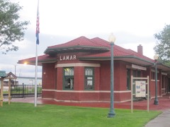 | Atchison, Topeka and Santa Fe Railway Passenger Depot | building | 2019 | 100004186 |
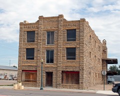 | Davies Hotel | building | 1978 | 78000875 |
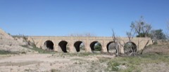 | Douglas Crossing Bridge | structure | 1985 | 85000224 |
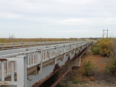 | Granada Bridge | structure | 2002 | 02001138 |
| Granada Historic Commercial District | district | 2025 | 100011970 | |
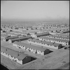 | Granada Relocation Center | site | 1994 | 94000425 |
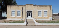 | Holly City Hall | building | 2003 | 03001010 |
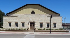 | Holly Gymnasium | building | 2007 | 07000344 |
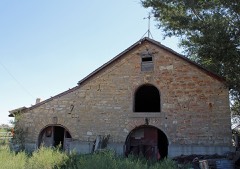 | Holly SS Ranch Barn | building | 2004 | 04000068 |
 | Holly Santa Fe Depot | building | 1995 | 95000935 |
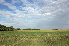 | Paulsen Farm | district | 1999 | 99001542 |
| Prowers Country Welfare Housing | district | 2009 | 09001121 | |
 | Prowers County Building | building | 1981 | 81000186 |
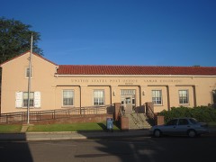 | US Post Office-Lamar Main | building | 1986 | 86000179 |
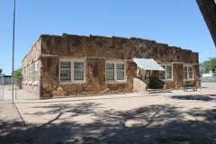 | Wiley Rock Schoolhouse | building | 2004 | 04000057 |
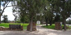 | Willow Creek Park | district | 2007 | 07000789 |
Every wildfire the federal occurrence database records inside this county: 540 of them, burning about 48,803 acres. 23 started naturally and 23 were recorded as arson. Each settlement page carries the fires within five miles of it.
| Reported cause | Fires |
|---|---|
| Missing data/not specified/undetermined | 331 |
| Recreation and ceremony | 109 |
| Natural | 23 |
| Equipment and vehicle use | 23 |
| Arson/incendiarism | 23 |
| Debris and open burning | 15 |
| Smoking | 10 |
| Misuse of fire by a minor | 6 |
The five largest, by the area the report gives. None of them was recorded as arson.
| Date | Cause | Size | Reported by | Name on the report |
|---|---|---|---|---|
| 3 March 2018 | Missing data/not specified/undetermined | 8,000 acres | Wiley Fire Department | RABBIT 22 FIRE |
| 19 October 2019 | Natural | 4,521 acres | Prowers County | EAGLE NEST |
| 25 August 2003 | Missing data/not specified/undetermined | 4,000 acres | Colorado State Forest Service-State Headquarters | not named |
| 23 July 1994 | Recreation and ceremony | 4,000 acres | Prowers County | not named |
| 19 July 2003 | Missing data/not specified/undetermined | 3,000 acres | Colorado State Forest Service-State Headquarters | not named |
| 23 May 2011 | Missing data/not specified/undetermined | 2,000 acres | Colorado State Forest Service-State Headquarters | LAMAR |
| 24 April 2009 | Missing data/not specified/undetermined | 1,500 acres | Kansas Counties | MCCRACKEN |
| 24 July 2005 | Missing data/not specified/undetermined | 1,500 acres | Colorado State Forest Service-State Headquarters | not named |
Every settlement page carries the fires within five miles of it - see the settlement index below.
The NOAA Storm Events Database holds 688 reports for this county, causing 3 deaths, 20 injuries and about $11,365,830 in recorded property damage. Each settlement page carries the reports that name it.
| Kind of event | Reports |
|---|---|
| Hail | 366 |
| Thunderstorm Wind | 178 |
| Tornado | 88 |
| Flash Flood | 28 |
| Funnel Cloud | 11 |
| Heavy Rain | 11 |
| Flood | 3 |
| Wildfire | 2 |
| Lightning | 1 |
The most serious of them, by death, then injury, then recorded damage. The accounts are quoted exactly as the forecast office filed them.
| When | Event | Place named | Harm | What the report says |
|---|---|---|---|---|
| March 2007 | Tornado (EF3) | Holly | 2 killed, 9 hurt, $4,000,000 | With a maximum rating of EF3 and a maximum damage path width of 900 yards, the tornado raced through Holly, causing two fatalities and nine injuries. |
| September 1998 | Lightning | Lamar | 1 killed, 3 hurt | no account filed |
| April 2012 | Tornado (EF2) | Lamar | 7 hurt, $500,000 | This long-track tornado began southeast of Lamar and damaged an electrical substation along county road EE. A power outage in the Lamar area lasted for over 12 hours. Two communication towers were downed...and four dwellings were destroyed. |
| June 1968 | Tornado (F2) | not stated | 1 hurt, $25,000 | no account filed |
| May 2001 | Hail | Lamar | $5,000,000 | The thunderstorms that spawned seven tornadoes west of Lamar, brought giant hail between golf ball and baseball size to Lamar. |
| April 2012 | Tornado (EF2) | Lamar Arpt | $500,000 | A hog farm was struck with 18 hog barns destroyed. There were no hogs on the farm at the time. |
| May 2010 | Hail | Lamar | $250,000 | Damaging large hail occurred in Lamar for around 15 minutes. |
| May 1989 | Tornado (F1) | not stated | $250,000 | no account filed |
| May 2001 | Tornado (F3) | Lamar | $150,000 | Thunderstorms spawned six brief tornadoes and an F3 tornado within a three mile radius of the Lamar Municipal Airport between 1049 MST and 1231 MST just west of Lamar. The F3 tornado, which showed supercellular characteristics, completely destroyed a modular home and five vehicles in its vicinity, and damaged two other homes nearby. Eleven power poles were destroyed as well. |
| August 2010 | Thunderstorm Wind | Holly | $80,000 | South of Holly, a powerful microburst flipped over five center pivot irrigation systems both west and east of Highway 89. Two grain bins were destroyed and one severely damaged. Several vehicles at houses just north of the grain bins had their windows blown out, and a camper trailer was toppled on its side. Twenty power poles had to be replaced along County Road DD west of Highway 89 around a mile south of Holly. |
| July 2016 | Thunderstorm Wind | Hartman | $70,000 | A house, outbuildings and grain storage bins were severely damaged. The residents were briefly trapped in a storm cellar. |
| June 2009 | Hail | Lamar Arpt | $50,000 | Many vehicles damaged on highway 287. |
| May 2003 | Thunderstorm Wind | Lamar | $50,000 | An intense rear flank downdraft caused heavy damage to several ranch buildings. Part of the wall, and the roof of a large building were destroyed. Smaller, less substantial structures were a total loss. |
| August 2002 | Flash Flood | Lamar | $50,000 | Heavy rain from severe thunderstorms caused flash flooding from the Willow Creek drainage basin in Lamar southward. A rental store sustained heavy flood damage between 7:30 p.m. and 8:00 p.m., as water was up to three feet deep on the property. A local golf course was closed because bridges and crossings over the creek were washed out. The greens suffered hail damage. Mud was deep in many streets on the south and east sides of Lamar in the Willow Creek drainage. Parts of highway 287, south of Lamar, were closed due to high water. |
| July 1996 | Tornado (F0) | Granada | $50,000 | no account filed |
| June 2012 | Thunderstorm Wind | Lamar | $30,000 | High winds caused numerous downed power poles...a collapsed awning at a gas station...and other scattered damage throughout the city. |
| June 2011 | Thunderstorm Wind | Holly | $30,000 | A microburst destroyed a hay barn. The debris damaged two vehicles...a tractor...baler...swather...and stack wagon. |
| June 1989 | Tornado (F1) | not stated | $25,000 | no account filed |
| June 1975 | Tornado (F2) | not stated | $25,000 | no account filed |
| June 1961 | Tornado (F1) | not stated | $25,000 | no account filed |
| June 1961 | Tornado (F1) | not stated | $25,000 | no account filed |
| August 2017 | Hail | Granada | $20,000 | Wind-driven hail broke windows of vehicles and houses. |
| September 2016 | Thunderstorm Wind | Wiley | $20,000 | Four utility poles were downed. |
| September 2016 | Thunderstorm Wind | Wiley | $20,000 | Irrigation pivot was destroyed. |
| June 2007 | Flash Flood | Lamar | $20,000 | An area of strong to severe thunderstorms produced very heavy rain in and around Lamar. Many streets were covered by at least 6 inches of water. |
| June 1996 | Thunderstorm Wind | Lamar | $15,000 | no account filed |
| September 2016 | Thunderstorm Wind | Wiley | $10,000 | A few power poles were knocked down, and a semi-trailer was blown over. |
| August 2015 | Thunderstorm Wind | Holly | $10,000 | Power lines were downed around Holly. |
| July 2011 | Thunderstorm Wind | Lamar | $10,000 | An unanchored mobile home flipped at CR13 between Highway 50 and Highway 96. |
| July 2010 | Tornado (EF0) | Lamar | $10,000 | A brief tornado brought down a 200-foot tall radio tower on the KLMR property. |
| July 2015 | Thunderstorm Wind | Lamar | $5,000 | Damage to tree limbs and power poles occurred across Lamar. |
| August 2015 | Thunderstorm Wind | Granada | $5,000 | A few power lines were downed around Granada. |
| August 2015 | Thunderstorm Wind | Lamar | $5,000 | A few power lines were downed around Lamar. |
| June 2008 | Tornado (EF0) | Granada | $5,000 | A tornado occurred over open country in north central Prowers County...narrowly missing ranch buildings. Some fencing was destroyed. |
| June 2009 | Hail | Holly | $5,000 | no account filed |
| June 2006 | Hail | Lamar | $5,000 | no account filed |
| July 2010 | Thunderstorm Wind | Wiley | $3,000 | Thunderstorm winds knocked down power poles to the east...1/4 mile south of the intersection of County Roads SS and 7. |
| May 1984 | Tornado (F1) | not stated | $2,500 | no account filed |
| July 1969 | Tornado (F1) | not stated | $2,500 | no account filed |
| June 1962 | Tornado (F1) | not stated | $2,500 | no account filed |
| May 1961 | Tornado (F1) | not stated | $2,500 | no account filed |
| July 2011 | Thunderstorm Wind | Lamar | $2,000 | A few telephone poles sustained damage. |
| June 1994 | Thunderstorm Wind | Hartman | $500 | Thunderstorm winds blew shingles of homes west of Hartman (61 miles east of La Junta). |
| June 1968 | Tornado (F1) | not stated | $250 | no account filed |
| May 1994 | Hail | Granada | $50 | Hail up to tennis-ball size fell south of Granada (17 miles east of Lamar), breaking a car windshield. |
| July 1958 | Tornado | not stated | $30 | no account filed |
| April 2025 | Thunderstorm Wind | Lamar Arpt | - | There was a 53 knot gusts measured at the LAA asos. |
| August 2025 | Thunderstorm Wind | Hartman | - | Mesonet station HLY02 Holly No. 2 measured a 58 mph wind gusts. |
| August 2025 | Thunderstorm Wind | Lamar Arpt | - | ASOS station KLAA Lamar Airport measured a 66 mph wind gust. |
| August 2025 | Thunderstorm Wind | Hartman | - | Mesonet station HLY02 Holly No. 2 measured a 65 mph wind gusts. |
| August 2025 | Thunderstorm Wind | Bristol | - | A measured wind gusts of 76 mph occurred in north central Prowers County. |
| August 2024 | Thunderstorm Wind | Lamar Arpt | - | ASOS at the Lamar Airport (KLAA) reported a measured thunderstorm wind gust of 64 mph. |
| August 2024 | Thunderstorm Wind | Granada | - | A public source reported a measured wind gust of 70 kts, and snapped tree branches, down power poles, damage to side of a barn. |
| August 2024 | Thunderstorm Wind | Lamar | - | A trained spotter reported thunderstorm wind damage, with large trees and fence posts downed in willow creek park in Lamar. |
| August 2024 | Thunderstorm Wind | Lamar Arpt | - | The ASOS Station at the Lamar Airport (KLAA) reported a measured thunderstorm wind gust of 68 kts. |
| May 2024 | Hail | Wiley | - | Hail of 1 inch in diameter was reported by a storm chaser via social media. |
| May 2024 | Thunderstorm Wind | Lamar Arpt | - | Lamar airport. |
| May 2024 | Funnel Cloud | Wiley | - | Multiple photos of a brief funnel cloud were reported on social media from different chasers. |
| May 2024 | Hail | Lamar | - | A public source via mPing, reported hail of 1 inch in diameter. |
| May 2024 | Hail | Lamar | - | A public source via mPing, reported hail of 1.75 inches in diameter. |
The Survey's mineral resources record lists 47 workings inside this county. 3 still produce and 44 are closed or unrecorded. Each settlement page carries the workings within five miles of it.
| Commodity | Workings |
|---|---|
| Sand and Gravel, Construction | 44 |
| Vanadium | 1 |
| Clay | 1 |
| Stone | 1 |
The least common of them first, because a county's hundredth gravel pit says nothing its first ten did not.
| Where | Site | Commodity | Status | Recorded |
|---|---|---|---|---|
| Clay Creek | Clay | Past Producer | ||
| Prowers Granite Qy | Stone | Producer | ||
| Two Buttes Vanadium Occurrence | Vanadium | Occurrence | ||
| Barrel Springs | Sand and Gravel, Construction | Past Producer | ||
| Borrow Pits | Sand and Gravel, Construction | Past Producer | ||
| Lamar Valley Concrete Pit & Plant | Sand and Gravel, Construction | Producer | ||
| Unk | Sand and Gravel, Construction | Past Producer | ||
| Unk | Sand and Gravel, Construction | Past Producer | ||
| Unk | Sand and Gravel, Construction | Past Producer | ||
| Unk | Sand and Gravel, Construction | Past Producer | ||
| Unk | Sand and Gravel, Construction | Past Producer | ||
| Unk | Sand and Gravel, Construction | Past Producer | ||
| Unk | Sand and Gravel, Construction | Past Producer | ||
| Unk | Sand and Gravel, Construction | Past Producer | ||
| Unk | Sand and Gravel, Construction | Past Producer | ||
| Unk | Sand and Gravel, Construction | Past Producer | ||
| Unk | Sand and Gravel, Construction | Past Producer | ||
| Unk | Sand and Gravel, Construction | Past Producer | ||
| Unk | Sand and Gravel, Construction | Past Producer | ||
| Unk | Sand and Gravel, Construction | Past Producer | ||
| Unk | Sand and Gravel, Construction | Past Producer | ||
| Unk | Sand and Gravel, Construction | Past Producer | ||
| Unk | Sand and Gravel, Construction | Past Producer | ||
| Unk | Sand and Gravel, Construction | Past Producer | ||
| Unk | Sand and Gravel, Construction | Past Producer | ||
| Unk | Sand and Gravel, Construction | Past Producer | ||
| Unk | Sand and Gravel, Construction | Past Producer | ||
| Unk | Sand and Gravel, Construction | Past Producer | ||
| Unk | Sand and Gravel, Construction | Past Producer | ||
| Unk | Sand and Gravel, Construction | Past Producer | ||
| Unk | Sand and Gravel, Construction | Past Producer | ||
| Unk | Sand and Gravel, Construction | Past Producer | ||
| Unk | Sand and Gravel, Construction | Past Producer | ||
| Unk | Sand and Gravel, Construction | Past Producer | ||
| Unk | Sand and Gravel, Construction | Past Producer | ||
| Unknown | Sand and Gravel, Construction | Occurrence | Gravel | |
| Unknown | Sand and Gravel, Construction | Occurrence | Gravel | |
| Unknown | Sand and Gravel, Construction | Occurrence | Gravel | |
| Unknown | Sand and Gravel, Construction | Occurrence | Gravel | |
| Unknown | Sand and Gravel, Construction | Occurrence | Gravel | |
| Unknown | Sand and Gravel, Construction | Occurrence | Gravel | |
| Unknown | Sand and Gravel, Construction | Occurrence | Gravel | |
| Unknown | Sand and Gravel, Construction | Occurrence | Gravel | |
| Unknown | Sand and Gravel, Construction | Occurrence | Gravel | |
| Unknown | Sand and Gravel, Construction | Occurrence | Gravel | |
| Unknown | Sand and Gravel, Construction | Occurrence | Gravel | |
| Wiley Pit | Sand and Gravel, Construction | Producer |
Named settlements recorded in the Geographic Names Information System, each with the topographic sheets covering it. Villages, hamlets and abandoned places alike. Each is shown with the nearest named watercourse or landform and the survey quadrangle it falls on.
Granada census division · 81052 · On Smith Arroyo · Carlton quadrangle
14 sheets, 1890 to 1988
Lamar census division · 81052 · On Markham Arroyo · May Valley quadrangle
15 sheets, 1892 to 1988
Granada census division · 81041 · On Wolf Creek · Granada quadrangle
16 sheets, 1890 to 1988
Granada census division · 81052 · On Smith Arroyo · Carlton quadrangle
14 sheets, 1890 to 1988
Granada census division · 81047 · On Cottonwood Creek · Carlton quadrangle
14 sheets, 1890 to 1988