 Block
From the record
One of 13 National Register listings published here for Moffat County · listed in 2000 · category: Structure.
Sources: the case file at the National Archives · the National Register database, National Park Service
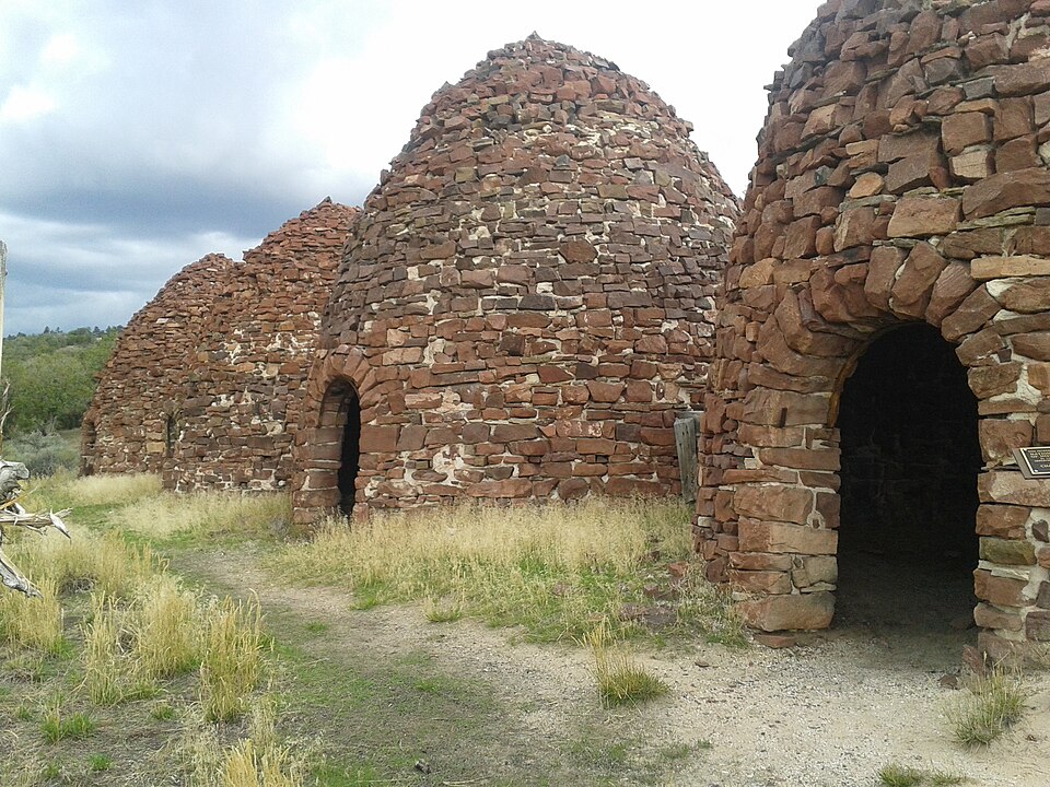
Listed on the National Register of Historic Places in 2000.
One of 13 National Register listings published here for Moffat County · listed in 2000 · category: Structure.
Sources: the case file at the National Archives · the National Register database, National Park Service
Regional context, not property-specific evidence. The federal wildfire occurrence database lists 201 fires within 5 miles of Bromide Charcoal Kilns between 1992 and 2020, burning about 1,977 acres in total. 199 started naturally. None was recorded as arson. Distance is straight-line from the map coordinates, so a fire counted here may appear on a neighbouring settlement's page as well.
| Reported cause | Fires |
|---|---|
| Natural | 199 |
| Equipment and vehicle use | 1 |
| Recreation and ceremony | 1 |
The most recent of them, most recent first, with the day each was reported and the service that recorded it.
| Date | Cause | Size | Reported by | Name on the report |
|---|---|---|---|---|
| 8 September 1995 | Natural | under an acre | Northwest District, Craig | DOUG |
| 7 September 2016 | Natural | under an acre | Northwest District, Craig | TEEPEE |
| 7 September 2001 | Natural | under an acre | Northwest District, Craig | DAVE |
| 7 September 1995 | Natural | under an acre | Northwest District, Craig | LIMESTONE |
| 5 September 1995 | Natural | under an acre | Northwest District, Craig | DRY |
| 5 September 1995 | Natural | under an acre | Northwest District, Craig | HARDING |
| 5 September 1995 | Natural | under an acre | Northwest District, Craig | GREYSTONE |
| 5 September 1993 | Natural | under an acre | Northwest District, Craig | WELLER |
Regional context, not property-specific evidence. The federal mineral resources record lists 3 workings within 5 miles of Bromide Charcoal Kilns: 2 occurrences, 1 past producer. None of them still produces. What was taken out: Sand and Gravel, Construction, Uranium. Distance is straight-line from the map coordinates, so a quarry counted here may appear on a neighbouring settlement's page as well.
| Where | Site | Commodity | Status | Recorded |
|---|---|---|---|---|
| Unknown | Uranium | Occurrence | ||
| Gravel Pit | Sand and Gravel, Construction | Past Producer | ||
| Unknown | Sand and Gravel, Construction | Occurrence | Gravel |
Regional context, not property-specific evidence. The National Weather Service names Greystone, the town this property stands in, in 11 storm reports between 1996 and 2025: 3 thunderstorm wind, 3 hail, 2 flash flood, 1 wildfire. The reports record 1 death. Each account below is quoted exactly as the forecast office filed it, from the NOAA Storm Events Database, and each date opens the federal record of that event.
| When | Event | Place named | Harm | What the report says |
|---|---|---|---|---|
| July 2019 | Flood | Greystone | 1 killed | A raft carrying several people down the Green River in Dinosaur National Monument flipped when it entered the rapids at Triplet Falls and became stuck on one of the rocks. Many of the passengers were ejected into the water and one man later died after he was pulled out of the river. |
| September 2013 | Flash Flood | Greystone | $20,000 | Heavy rainfall on saturated soils led to flash flooding in the Browns Park National Wildlife Refuge, including flood waters that ran into basements of homes. |
| September 2013 | Hail | Greystone | $12,000 | The hail was reported to have damaged cars in the area. |
| June 2025 | Thunderstorm Wind | Greystone | - | The Dinosaur NM 19N RAWS recorded a gust to 62 mph at approximately 8:22 PM MDT on June 12th. This gust was associated with a small thunderstorm that had formed over the Dinosaur National Monument area. This was the only gust recorded in the area, and no reports of damages, injuries, or fatalities were received associated with it. |
| July 2024 | Flash Flood | Greystone | - | Heavy rainfall rates of 0.5 to 1 inch in less than an hour from a strong thunderstorm resulted in flash flooding in Hells Canyon through Dinosaur National Monument. An additional inch accumulation of pea sized hail also accompanied the heavy rain resulting in the flash flooding. |
| June 2020 | Thunderstorm Wind | Greystone | - | A peak wind gust of 67 mph was measured by an automated weather station northwest of Greystone. |
| September 2007 | Hail | Greystone | - | Hail was observed at Roundtop Tower Lookout in Dinosaur National Monument. |
| September 2007 | Hail | Greystone | - | Hail observed at Zenobia Tower Outlook in Dinosaur National Monument. |
| July 2005 | Heavy Rain | Greystone | - | no account filed |
| August 2000 | Wildfire | Greystone | - | no account filed |
| June 1996 | Thunderstorm Wind | Greystone | - | no account filed |
No historic map-sheet match is published for this property yet. That does not mean no map exists. This record needs a coordinate-quality review before it can be joined to a sheet boundary. Browse the county's mapped places while that work is pending.
| National Archives record | The nomination case file for reference 00000740 in Record Group 79. |
| Moffat County | All 13 listed properties in this county. |