 Block
From the record
One of 19 National Register listings published here for Otero County · listed in 2008 · category: Building.
Sources: the case file at the National Archives · the National Register database, National Park Service
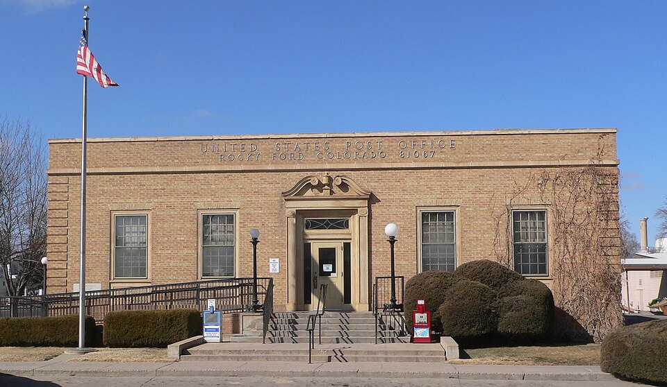
Listed on the National Register of Historic Places in 2008.
One of 19 National Register listings published here for Otero County · listed in 2008 · category: Building.
Sources: the case file at the National Archives · the National Register database, National Park Service
Regional context, not property-specific evidence. The federal wildfire occurrence database lists 244 fires within 5 miles of Rocky Ford Post Office between 1995 and 2020, burning about 3,139 acres in total. 5 started naturally. 1 was recorded as arson. Distance is straight-line from the map coordinates, so a fire counted here may appear on a neighbouring settlement's page as well.
| Reported cause | Fires |
|---|---|
| Missing data/not specified/undetermined | 181 |
| Recreation and ceremony | 16 |
| Debris and open burning | 14 |
| Smoking | 13 |
| Equipment and vehicle use | 8 |
| Natural | 5 |
| Fireworks | 3 |
| Railroad operations and maintenance | 1 |
| Misuse of fire by a minor | 1 |
| Power generation/transmission/distribution | 1 |
| Arson/incendiarism | 1 |
The most recent of them, most recent first, with the day each was reported and the service that recorded it.
| Date | Cause | Size | Reported by | Name on the report |
|---|---|---|---|---|
| 5 September 2020 | Missing data/not specified/undetermined | under an acre | Rocky Ford Fire Department | N/A |
| 28 September 2017 | Missing data/not specified/undetermined | under an acre | Rocky Ford Fire Department | UNKNOWN |
| 26 September 2016 | Missing data/not specified/undetermined | under an acre | Rocky Ford Fire Department | UNKNOWN |
| 24 September 2003 | Missing data/not specified/undetermined | 1.0 acres | Colorado State Forest Service-State Headquarters | not named |
| 18 September 2016 | Missing data/not specified/undetermined | under an acre | Rocky Ford Fire Department | UNKNOWN |
| 1 September 2003 | Missing data/not specified/undetermined | 1.0 acres | Colorado State Forest Service-State Headquarters | not named |
| 31 August 2018 | Missing data/not specified/undetermined | under an acre | Rocky Ford Fire Department | UNKNOWN |
| 31 August 2005 | Missing data/not specified/undetermined | 2.0 acres | Colorado State Forest Service-State Headquarters | not named |
Regional context, not property-specific evidence. The federal mineral resources record lists 15 workings within 5 miles of Rocky Ford Post Office: 9 unknowns, 4 occurrences, 2 producers. 2 still produce. What was taken out: Sand and Gravel, Construction, Stone, Stone, Dimension. Distance is straight-line from the map coordinates, so a quarry counted here may appear on a neighbouring settlement's page as well.
| Where | Site | Commodity | Status | Recorded |
|---|---|---|---|---|
| Unknown | Stone, Dimension | Occurrence | ||
| Unk | Stone | Unknown | ||
| Unk | Stone | Unknown | ||
| Unk | Stone | Unknown | ||
| Hancock Pit | Sand and Gravel, Construction | Producer | ||
| Korinek Trout Farm Pit | Sand and Gravel, Construction | Unknown | ||
| Unk | Sand and Gravel, Construction | Unknown | ||
| Unk | Sand and Gravel, Construction | Unknown | ||
| Unk | Sand and Gravel, Construction | Unknown | ||
| Unk | Sand and Gravel, Construction | Unknown |
Regional context, not property-specific evidence. The National Weather Service names Rocky Ford, the town this property stands in, in 54 storm reports between 1995 and 2024: 38 hail, 6 thunderstorm wind, 5 heavy rain, 2 flash flood. The reports record 1 death. Each account below is quoted exactly as the forecast office filed it, from the NOAA Storm Events Database, and each date opens the federal record of that event.
| When | Event | Place named | Harm | What the report says |
|---|---|---|---|---|
| September 2005 | Lightning | Rocky Ford | 1 killed | A 36-year old man was struck and killed by lightning while work outside on a farm. |
| August 2003 | Thunderstorm Wind | Rocky Ford | $50,000 | no account filed |
| August 2004 | Lightning | Rocky Ford | $4,000 | A lightning strike caused a haystack to catch fire. |
| July 2024 | Flash Flood | Rocky Ford | - | Flooded intersection at Highway 50 and Steen Ave, in La Junta, began at 8:55pm MDT. Road closed due to high water. |
| August 2022 | Thunderstorm Wind | Rocky Ford | - | Two power poles blow over. |
| July 2022 | Thunderstorm Wind | Rocky Ford | - | Otero county sheriffs office reported numerous trees down across the county. |
| July 2022 | Heavy Rain | Rocky Ford | - | Heavy rainfall of 2.50 inches. |
| July 2022 | Heavy Rain | Rocky Ford | - | Heavy rainfall of 2.54 inches. |
| July 2022 | Heavy Rain | Rocky Ford | - | Heavy rainfall of 2.05 inches. |
| July 2022 | Heavy Rain | Rocky Ford | - | Heavy rainfall of 1.98 inches. |
| July 2022 | Heavy Rain | Rocky Ford | - | Heavy rainfall of 1.51 inches. |
| May 2021 | Tornado (EFU) | Rocky Ford | - | Public reported tornado on the ground, that lasted 5 minutes. |
| June 2019 | Hail | Rocky Ford | - | Storm chaser reported nickel hail. |
| August 2019 | Hail | Rocky Ford | - | A report from CoCoRaHS relayed one inch hail was the largest stone found but that it also hailed for 20 straight minutes. |
| May 2016 | Thunderstorm Wind | Rocky Ford | - | One foot diameter branches ripped off a tree. |
| June 2013 | Hail | Rocky Ford | - | Hail ranged in size from quarters to golf balls. |
| June 2004 | Thunderstorm Wind | Rocky Ford | - | Strong thunderstorm winds caused 8 inch diameter tree limbs to go down. |
| July 1999 | Flash Flood | Rocky Ford | - | Very heavy rain fell in a few hours time from just south of Manzanola to about five miles northwest of Rocky Ford near U.S. Highway 50. The resulting flood closed highway 50 for six hours Saturday morning. Widespread flooding occurred from county roads 11 to 16. Many road washouts were reported and damage occurred to two irrigation canals. A residence was destroyed by two foot deep flood waters. The railroad just south of highway 50 was undermined when the trestle abutments washed away. No firm damage amounts were available as of late September. |
| July 2023 | Hail | Rocky Ford | - | no account filed |
| July 2023 | Hail | Rocky Ford | - | no account filed |
| August 2017 | Hail | Rocky Ford | - | no account filed |
| May 2016 | Hail | Rocky Ford | - | no account filed |
| May 2016 | Hail | Rocky Ford | - | no account filed |
| June 2016 | Hail | Rocky Ford | - | no account filed |
| June 2016 | Hail | Rocky Ford | - | no account filed |
| June 2016 | Hail | Rocky Ford | - | no account filed |
| August 2015 | Hail | Rocky Ford | - | no account filed |
| August 2015 | Hail | Rocky Ford | - | no account filed |
| July 2014 | Hail | Rocky Ford | - | no account filed |
| June 2013 | Hail | Rocky Ford | - | no account filed |
| September 2012 | Hail | Rocky Ford | - | no account filed |
| May 2010 | Hail | Rocky Ford | - | no account filed |
| June 2010 | Hail | Rocky Ford | - | no account filed |
| June 2010 | Hail | Rocky Ford | - | no account filed |
| June 2010 | Hail | Rocky Ford | - | no account filed |
| June 2010 | Hail | Rocky Ford | - | no account filed |
| June 2010 | Hail | Rocky Ford | - | no account filed |
| June 2009 | Hail | Rocky Ford | - | no account filed |
| June 2009 | Hail | Rocky Ford | - | no account filed |
| June 2007 | Hail | Rocky Ford | - | no account filed |
| August 2007 | Hail | Rocky Ford | - | no account filed |
| June 2005 | Hail | Rocky Ford | - | no account filed |
| June 2004 | Hail | Rocky Ford | - | no account filed |
| June 2004 | Hail | Rocky Ford | - | no account filed |
| May 2003 | Hail | Rocky Ford | - | no account filed |
| June 2001 | Hail | Rocky Ford | - | no account filed |
| September 2000 | Thunderstorm Wind | Rocky Ford | - | no account filed |
| July 2000 | Hail | Rocky Ford | - | no account filed |
| May 1999 | Hail | Rocky Ford | - | no account filed |
| May 1999 | Hail | Rocky Ford | - | no account filed |
| May 1998 | Hail | Rocky Ford | - | no account filed |
| July 1996 | Hail | Rocky Ford | - | no account filed |
| August 1996 | Hail | Rocky Ford | - | no account filed |
| June 1995 | Hail | Rocky Ford | - | no account filed |
No historic map-sheet match is published for this property yet. That does not mean no map exists. This record needs a coordinate-quality review before it can be joined to a sheet boundary. Browse the county's mapped places while that work is pending.
Other National Register properties close enough to walk or drive between, ordered by distance from this one. Both positions come from the same geocoding pass that matched these properties to their map sheets.
| Photograph | Property | Distance | Listed |
|---|---|---|---|
 | Carnegie Public Library | 0.4 miles | 1995 |
 | Adobe Stables, Arkansas Valley Fairgrounds | 0.4 miles | 2007 |
 | Art Building | 1.0 miles | 1996 |
| Valley View-Hillcrest Cemetery | 1.3 miles | 2024 | |
| Swink School | 5.8 miles | 2025 |
| National Archives record | The nomination case file for reference 07001394 in Record Group 79. |
| Otero County | All 19 listed properties in this county. |