 Block
From the record
One of 26 National Register listings published here for Las Animas County · listed in 2008 · category: Building.
Sources: the case file at the National Archives · the National Register database, National Park Service
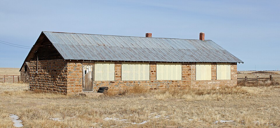
Listed on the National Register of Historic Places in 2008.
One of 26 National Register listings published here for Las Animas County · listed in 2008 · category: Building.
Sources: the case file at the National Archives · the National Register database, National Park Service
Regional context, not property-specific evidence. The federal wildfire occurrence database lists 4 fires within 5 miles of White School between 1994 and 1997, burning about 27 acres in total. 2 started naturally. None was recorded as arson. Distance is straight-line from the map coordinates, so a fire counted here may appear on a neighbouring settlement's page as well.
| Reported cause | Fires |
|---|---|
| Natural | 2 |
| Recreation and ceremony | 1 |
| Missing data/not specified/undetermined | 1 |
The most recent of them, most recent first, with the day each was reported and the service that recorded it.
| Date | Cause | Size | Reported by | Name on the report |
|---|---|---|---|---|
| 7 August 1995 | Recreation and ceremony | 1.0 acres | Las Animas County | not named |
| 6 July 1997 | Natural | 1.0 acres | Pike and San Isabel National Forest | MIDWAY |
| 4 March 1994 | Missing data/not specified/undetermined | 10 acres | Las Animas County | not named |
| 6 February 1994 | Natural | 15 acres | Las Animas County | not named |
Regional context, not property-specific evidence. The National Weather Service names Kim, the town this property stands in, in 88 storm reports between 1993 and 2025: 71 hail, 6 thunderstorm wind, 6 tornado, 3 flash flood. No death or injury is recorded in these reports. Each account below is quoted exactly as the forecast office filed it, from the NOAA Storm Events Database, and each date opens the federal record of that event.
| When | Event | Place named | Harm | What the report says |
|---|---|---|---|---|
| October 1997 | Thunderstorm Wind | Kim | $1,000 | A severe thunderstorm quickly developed along a line of thunderstorms moving east through southeast Colorado. The high winds seems to be shortlived and a couple of trampolines were damaged and destroyed. No damage to structures was reported. |
| June 2025 | Hail | Kim | - | Hail up to 2 inches in diameter fell in Las Animas County from a supercell thunderstorm. |
| June 2025 | Hail | Kim | - | Hail up to 2 inches in diameter fell in Las Animas County from a supercell thunderstorm. |
| June 2025 | Hail | Kim | - | Hail up to 2 inches in diameter fell in Las Animas County from a supercell thunderstorm. |
| June 2025 | Hail | Kim | - | Hail up to 3 inches in diameter fell in Las Animas County from a supercell thunderstorm. |
| August 2025 | Hail | Kim | - | Hail measured to 3 inches fell in eastern Las Animas County. |
| August 2025 | Hail | Kim | - | Hail measured to 3 inches fell in eastern Las Animas County. |
| August 2025 | Hail | Kim | - | Hail measured to 3.25 inches fell in eastern Las Animas County. |
| August 2025 | Hail | Kim | - | Hail measured to 2 inches fell in eastern Las Animas County. |
| August 2024 | Hail | Kim | - | A COOP Observer reported hail of .88 inches in diameter. |
| July 2023 | Tornado (EFU) | Kim | - | Brief tornado reported by a storm chaser 15 miles northeast of Kim. |
| August 2023 | Hail | Kim | - | Via social media. |
| June 2022 | Hail | Kim | - | Chaser reported 1.25 inch hail. |
| May 2021 | Tornado (EFU) | Kim | - | Large tornado via social media. Numerous reports from storm chasers in the vicinity of large tornado. |
| May 2021 | Tornado (EFU) | Kim | - | Cone shaped tornado spotter over rural Las Animas County. |
| July 2020 | Thunderstorm Wind | Kim | - | Wind gusts estimated at 60 mph three miles west of Kim. |
| June 2019 | Hail | Kim | - | COOP observer reported nickel size hail. |
| May 2015 | Tornado (EF0) | Kim | - | A landspout moved across open country and caused no damage. |
| July 2014 | Flash Flood | Kim | - | Strong storms produced very heavy rain and flash flooding across county roads in the extreme southeast corner of the county. |
| April 2012 | Funnel Cloud | Kim | - | Short-lived condensation funnel dropped 3/4 of the way to the ground. |
| August 2011 | Flash Flood | Kim | - | One foot of water was flowing across State Highway 109 north of Kim, and washed some fencing away. |
| May 2010 | Thunderstorm Wind | Kim | - | Large limbs were ripped off juniper trees along a narrow path approximately two miles in length in open country. There was no evidence of rotation in the debris fields. |
| July 2009 | Flash Flood | Kim | - | Thunderstorms produced heavy rain which caused deep water over roadways and washouts. |
| May 2005 | Tornado (F0) | Kim | - | Short lived tornado caused no known damage. |
| July 2004 | Tornado (F0) | Kim | - | A tornado tore up some fence and threw three feed troughs a few hundred feet south of Kim. |
| July 2004 | Thunderstorm Wind | Kim | - | Strong thunderstorm winds knocked 3 to 4 inch diameter limbs off of trees. |
| August 1993 | Hail | Kim | - | A severe thunderstorm dropped hail up to golfball-size in Kim (49 miles south of La Junta). Thunderstorm winds damaged several trees. |
| August 1993 | Thunderstorm Wind | Kim | - | A severe thunderstorm dropped hail up to golfball-size in Kim (49 miles south of La Junta). Thunderstorm winds damaged several trees. |
| May 2021 | Hail | Kim | - | no account filed |
| May 2020 | Hail | Kim | - | no account filed |
| May 2017 | Hail | Kim | - | no account filed |
| May 2017 | Hail | Kim | - | no account filed |
| July 2016 | Hail | Kim | - | no account filed |
| June 2015 | Hail | Kim | - | no account filed |
| June 2015 | Hail | Kim | - | no account filed |
| May 2015 | Hail | Kim | - | no account filed |
| July 2013 | Hail | Kim | - | no account filed |
| June 2012 | Hail | Kim | - | no account filed |
| July 2011 | Hail | Kim | - | no account filed |
| May 2010 | Hail | Kim | - | no account filed |
| July 2010 | Hail | Kim | - | no account filed |
| July 2009 | Hail | Kim | - | no account filed |
| July 2009 | Hail | Kim | - | no account filed |
| July 2009 | Hail | Kim | - | no account filed |
| July 2009 | Hail | Kim | - | no account filed |
| August 2009 | Hail | Kim | - | no account filed |
| June 2007 | Hail | Kim | - | no account filed |
| August 2007 | Hail | Kim | - | no account filed |
| June 2006 | Hail | Kim | - | no account filed |
| June 2006 | Hail | Kim | - | no account filed |
| September 2006 | Hail | Kim | - | no account filed |
| May 2005 | Hail | Kim | - | no account filed |
| May 2005 | Hail | Kim | - | no account filed |
| May 2005 | Hail | Kim | - | no account filed |
| May 2005 | Hail | Kim | - | no account filed |
| September 2005 | Hail | Kim | - | no account filed |
| June 2004 | Hail | Kim | - | no account filed |
| June 2004 | Hail | Kim | - | no account filed |
| July 2004 | Hail | Kim | - | no account filed |
| May 2003 | Hail | Kim | - | no account filed |
No historic map-sheet match is published for this property yet. That does not mean no map exists. This record needs a coordinate-quality review before it can be joined to a sheet boundary. Browse the county's mapped places while that work is pending.
Other National Register properties close enough to walk or drive between, ordered by distance from this one. Both positions come from the same geocoding pass that matched these properties to their map sheets.
| Photograph | Property | Distance | Listed |
|---|---|---|---|
 | Kim Schools | 4.2 miles | 2007 |
| National Archives record | The nomination case file for reference 08000740 in Record Group 79. |
| Las Animas County | All 26 listed properties in this county. |