 Block
From the record
One of 10 National Register listings published here for Custer County · listed in 2008 · category: Building.
Sources: the case file at the National Archives · the National Register database, National Park Service
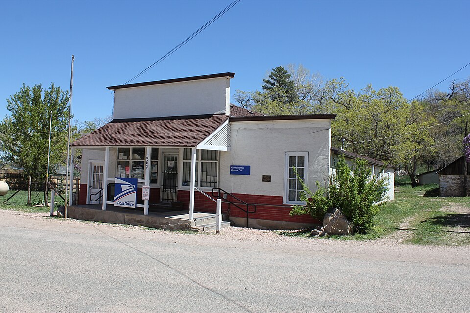
Listed on the National Register of Historic Places in 2008.
One of 10 National Register listings published here for Custer County · listed in 2008 · category: Building.
Sources: the case file at the National Archives · the National Register database, National Park Service
Regional context, not property-specific evidence. The federal wildfire occurrence database lists 52 fires within 5 miles of Wetmore Post Office between 1992 and 2020, burning about 3,081 acres in total. 25 started naturally. None was recorded as arson. Distance is straight-line from the map coordinates, so a fire counted here may appear on a neighbouring settlement's page as well.
| Reported cause | Fires |
|---|---|
| Natural | 25 |
| Missing data/not specified/undetermined | 18 |
| Recreation and ceremony | 4 |
| Debris and open burning | 2 |
| Equipment and vehicle use | 1 |
| Power generation/transmission/distribution | 1 |
| Misuse of fire by a minor | 1 |
The most recent of them, most recent first, with the day each was reported and the service that recorded it.
| Date | Cause | Size | Reported by | Name on the report |
|---|---|---|---|---|
| 30 September 2001 | Natural | under an acre | Pike and San Isabel National Forest | FARLEY |
| 3 September 2016 | Natural | under an acre | Wetmore Volunteer Fire Department | UNKNOWN |
| 2 September 2009 | Natural | 2.0 acres | Pike and San Isabel National Forest | HOLT MTN |
| 28 August 2000 | Natural | under an acre | Royal Gorge Field Office | MASON GUL |
| 28 August 1995 | Natural | 1.0 acres | Royal Gorge Field Office | YMCA MTN |
| 23 August 2016 | Missing data/not specified/undetermined | under an acre | Pike and San Isabel National Forest | LUIS CREEK 6 |
| 23 August 2016 | Missing data/not specified/undetermined | 7.0 acres | Wetmore Volunteer Fire Department | UNKNOWN |
| 23 August 2016 | Missing data/not specified/undetermined | 4.0 acres | Wet Mountain Fire Protection District | UNKNOWN |
Regional context, not property-specific evidence. The federal mineral resources record lists 11 workings within 5 miles of Wetmore Post Office: 5 producers, 5 occurrences, 1 past producer. 5 still produce. What was taken out: Sand and Gravel, Construction, Clay, Uranium, Fire Clay (Refractory). Distance is straight-line from the map coordinates, so a quarry counted here may appear on a neighbouring settlement's page as well.
| Where | Site | Commodity | Status | Recorded |
|---|---|---|---|---|
| Airborne Anomaly 18 | Uranium | Occurrence | ||
| Colorado Zinc Company Mine | Lead, Zinc | Producer | Galena, Sphalerite | |
| Unknown | Fire Clay (Refractory) | Occurrence | ||
| Lawson Mine | Clay | Past Producer | ||
| Unknown | Clay | Occurrence | Clay | |
| Unknown | Clay | Occurrence | Clay | |
| Gravel Pit | Sand and Gravel, Construction | Producer | ||
| Gravel Pit | Sand and Gravel, Construction | Producer | ||
| Gravel Pit | Sand and Gravel, Construction | Producer | ||
| Gravel Pit | Sand and Gravel, Construction | Producer |
Regional context, not property-specific evidence. The National Weather Service names Wetmore, the town this property stands in, in 36 storm reports between 1996 and 2024: 14 flash flood, 12 heavy rain, 8 hail, 1 thunderstorm wind. No death or injury is recorded in these reports. Each account below is quoted exactly as the forecast office filed it, from the NOAA Storm Events Database, and each date opens the federal record of that event.
| When | Event | Place named | Harm | What the report says |
|---|---|---|---|---|
| June 2024 | Heavy Rain | Wetmore | - | Trained spotter reported heavy rain from a thunderstorm, which produced 0.90 inches of rainfall over a short duration. |
| May 2023 | Heavy Rain | Wetmore | - | There was 1.5 inches of rain that fell. |
| July 2022 | Heavy Rain | Wetmore | - | Heavy rainfall of 1.1 inches. |
| July 2021 | Heavy Rain | Wetmore | - | Heavy rainfall of 2.00 inches. |
| July 2021 | Flash Flood | Wetmore | - | Extensive road damage was observed. A 7 foot wall of water developed due to a culvert plugging up. County roads 271, 261, and 265 all remained closed throughout the night. |
| August 2021 | Heavy Rain | Wetmore | - | Heavy rainfall of 1.40 inches. |
| July 2021 | Heavy Rain | Wetmore | - | Heavy rainfall of 1.50 inches. |
| July 2021 | Heavy Rain | Wetmore | - | Heavy rainfall of 1.20 inches. |
| May 2021 | Heavy Rain | Wetmore | - | Spotter indicated it was a combination of rain and snow, 1.00 inches 2 miles south southwest of Wetmore. |
| May 2021 | Heavy Rain | Wetmore | - | Heavy rain of 3.75 inches, 2 miles south southwest Wetmore. |
| August 2020 | Debris Flow | Wetmore | - | Colorado State Patrol has closed Highway 96, from Highway 165 to Highway 67 due to rock and mudslides. |
| July 2019 | Heavy Rain | Wetmore | - | Spotter reported over 1.5 inches of rain fell within an hour. |
| July 2019 | Flash Flood | Wetmore | - | Local FD reported that Hardscrabble Creek came out of its banks. Also, multiple rock and mudslides across US Hwy 96, shutting the road down. |
| July 2019 | Flash Flood | Wetmore | - | Highway 96 is closed between CO 165 and Smith Creek road for debris flows. |
| August 2019 | Heavy Rain | Wetmore | - | Spotter measured 1.7 inches of rain. |
| August 2019 | Flash Flood | Wetmore | - | Trained spotter reported heavy rain producing minor street flooding and also causing rock slides across us hwy 96. |
| August 2018 | Flash Flood | Wetmore | - | Heavy rainfall over the Junkins burn scar caused flash flooding and debris flows across Highway 384, 6 miles south of Wetmore, CO. |
| July 2018 | Flash Flood | Wetmore | - | A sheriff reported washouts over County Road 387, downstream of the Junkins Burn Scar in Custer County. |
| July 2018 | Flash Flood | Wetmore | - | A thunderstorm's interaction with the Junkins Burn Scar caused flash flooding over Highway 165 in Custer County. |
| July 2018 | Flash Flood | Wetmore | - | Emergency Management reported a flash flooding from hardscrabble creek near Greenwood causing water to flow over County Road 96. |
| July 2018 | Flash Flood | Wetmore | - | A trained spotter reported flash flooding from the Junkins Burn Scar over County Roads 386 and 389. |
| June 2017 | Flash Flood | Wetmore | - | County Road 387 was briefly closed due to debris on the road in eight different areas. |
| August 2005 | Flash Flood | Wetmore | - | Heavy thunderstorm rains caused flash flooding on the Mason Gulch Burn Scar in northeastern Custer County. |
| May 2020 | Heavy Rain | Wetmore | - | no account filed |
| May 2017 | Hail | Wetmore | - | no account filed |
| August 2017 | Hail | Wetmore | - | no account filed |
| June 2015 | Hail | Wetmore | - | no account filed |
| July 2008 | Hail | Wetmore | - | no account filed |
| July 2006 | Flash Flood | Wetmore | - | no account filed |
| July 2005 | Flash Flood | Wetmore | - | no account filed |
| June 2001 | Hail | Wetmore | - | no account filed |
| July 2001 | Hail | Wetmore | - | no account filed |
| June 1998 | Hail | Wetmore | - | no account filed |
| August 1998 | Flash Flood | Wetmore | - | no account filed |
| August 1997 | Thunderstorm Wind | Wetmore | - | no account filed |
| June 1996 | Hail | Wetmore | - | no account filed |
No historic map-sheet match is published for this property yet. That does not mean no map exists. This record needs a coordinate-quality review before it can be joined to a sheet boundary. Browse the county's mapped places while that work is pending.
| National Archives record | The nomination case file for reference 08000860 in Record Group 79. |
| Custer County | All 10 listed properties in this county. |