 Block
From the record
10 National Register listings published here.
Sources: the National Register database, National Park Service
84 topographic sheets cover 12 settlements here, and 10 properties are on the National Register of Historic Places.
10 National Register listings published here.
Sources: the National Register database, National Park Service
Every property in this county listed on the National Register of Historic Places, with the year it was listed and the federal nomination document.
| Photograph | Property | Type | Listed | Reference |
|---|---|---|---|---|
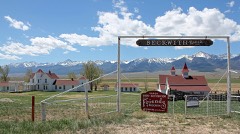 | Beckwith Ranch | district | 1998 | 98000568 |
| Holdsworth House-Aspenholme-Pines Lodge | building | 2021 | 100006742 | |
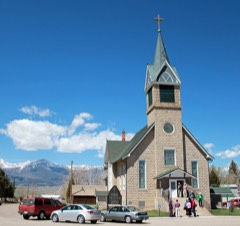 | Hope Lutheran Church | building | 1978 | 78000838 |
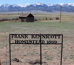 | Kennicott Cabin | building | 1997 | 97000046 |
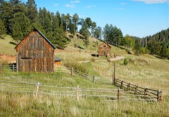 | Mingus Homestead | district | 1990 | 90001791 |
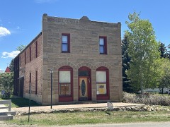 | National Hotel-Wolff Building | building | 1987 | 87001288 |
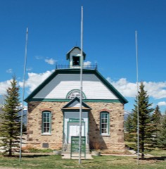 | Westcliff School | building | 1989 | 89000999 |
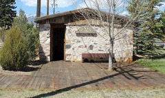 | Westcliffe Jail | building | 1993 | 92001846 |
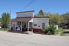 | Wetmore Post Office | building | 2008 | 08000860 |
| Willows School | building | 1993 | 93000413 |
Every wildfire the federal occurrence database records inside this county: 285 of them, burning about 27,094 acres. 144 started naturally and 1 was recorded as arson. Each settlement page carries the fires within five miles of it.
| Reported cause | Fires |
|---|---|
| Natural | 144 |
| Missing data/not specified/undetermined | 76 |
| Recreation and ceremony | 28 |
| Equipment and vehicle use | 14 |
| Power generation/transmission/distribution | 8 |
| Debris and open burning | 7 |
| Smoking | 5 |
| Misuse of fire by a minor | 2 |
| Arson/incendiarism | 1 |
The five largest, by the area the report gives. None of them was recorded as arson.
| Date | Cause | Size | Reported by | Name on the report |
|---|---|---|---|---|
| 17 October 2016 | Power generation/transmission/distribution | 18,320 acres | Pike and San Isabel National Forest | JUNKINS |
| 12 June 2011 | Recreation and ceremony | 4,000 acres | Pike and San Isabel National Forest | DUCKETT |
| 23 October 2012 | Power generation/transmission/distribution | 1,998 acres | Royal Gorge Field Office | WETMORE |
| 29 April 2011 | Missing data/not specified/undetermined | 552 acres | Colorado State Forest Service-State Headquarters | WETMORE |
| 14 June 2006 | Power generation/transmission/distribution | 541 acres | Royal Gorge Field Office | TYNDALL GULCH |
| 27 April 2011 | Natural | 495 acres | Pike and San Isabel National Forest | SAND GULCH |
| 14 September 2007 | Missing data/not specified/undetermined | 300 acres | Pike and San Isabel National Forest | BIG COTTONWOOD |
| 8 July 1993 | Natural | 250 acres | Pike and San Isabel National Forest | SOUTH LAKE |
Every settlement page carries the fires within five miles of it - see the settlement index below.
The NOAA Storm Events Database holds 164 reports for this county, causing 2 deaths, 2 injuries and about $229,500 in recorded property damage. Each settlement page carries the reports that name it.
| Kind of event | Reports |
|---|---|
| Hail | 92 |
| Heavy Rain | 25 |
| Flash Flood | 23 |
| Tornado | 9 |
| Thunderstorm Wind | 5 |
| Funnel Cloud | 5 |
| Wildfire | 2 |
| Lightning | 2 |
| Debris Flow | 1 |
The most serious of them, by death, then injury, then recorded damage. The accounts are quoted exactly as the forecast office filed them.
| When | Event | Place named | Harm | What the report says |
|---|---|---|---|---|
| August 2011 | Lightning | Westcliffe | 1 killed, 1 hurt | no account filed |
| July 2008 | Lightning | Rosita | 1 killed | no account filed |
| June 1992 | Hail | not stated | 1 hurt | no account filed |
| April 2002 | Wildfire | Westcliffe | $100,000 | no account filed |
| May 2002 | Wildfire | Westcliffe | $100,000 | no account filed |
| July 2003 | Flash Flood | Westcliffe | $20,000 | no account filed |
| July 2009 | Flash Flood | San Isabel | $4,000 | Six inches of water was observed flowing over roadways...with several gravel roads washed out and impassable. |
| July 1960 | Tornado (F2) | not stated | $2,500 | no account filed |
| February 1954 | Tornado (F1) | not stated | $2,500 | no account filed |
| August 1993 | Hail | Westcliffe | $500 | Severe thunderstorms rolled through portions of Chaffee and Custer Counties. Hail up to walnut-size damaged windows in Johnson Village (21 miles northwest of Salida) and Westcliffe. |
| October 2025 | Thunderstorm Wind | Rosita | - | Mesonet station AW342 Highlands Ranch observed a 61 mph wind gust with a decaying thunderstorm. |
| July 2025 | Tornado (EF0) | Silver Cliff | - | Brief landspout tornado developed over an open field in Custer County. 3 power poles were damaged. A virtual damage assessment was completed with a rating of EF-0 and 85 MPH max wind gusts. |
| July 2025 | Hail | Rosita | - | Hail measured to 1.25 inches occurred in Custer County. |
| May 2024 | Funnel Cloud | Westcliffe | - | Cold air funnel, documented by video moving over Eureka Mountain and Spread Eagle Peak. |
| June 2024 | Heavy Rain | Wetmore | - | Trained spotter reported heavy rain from a thunderstorm, which produced 0.90 inches of rainfall over a short duration. |
| May 2023 | Heavy Rain | Wetmore | - | There was 1.5 inches of rain that fell. |
| August 2022 | Heavy Rain | Rosita | - | Observer reported 0.95 inches of rain in an hour. |
| July 2022 | Heavy Rain | Rosita | - | Heavy rainfall of 1.00 inches. |
| July 2022 | Heavy Rain | Rosita | - | Heavy rainfall of 1.00 inches, fell in one hour. |
| July 2022 | Heavy Rain | Wetmore | - | Heavy rainfall of 1.1 inches. |
| July 2021 | Heavy Rain | Wetmore | - | Heavy rainfall of 2.00 inches. |
| July 2021 | Heavy Rain | San Isabel | - | Heavy rainfall of 1.61 inches. |
| July 2021 | Heavy Rain | San Isabel | - | Heavy rainfall of 1.44 inches. |
| July 2021 | Flash Flood | Wetmore | - | Extensive road damage was observed. A 7 foot wall of water developed due to a culvert plugging up. County roads 271, 261, and 265 all remained closed throughout the night. |
| August 2021 | Heavy Rain | Wetmore | - | Heavy rainfall of 1.40 inches. |
| August 2021 | Heavy Rain | Rosita | - | Heavy rainfall of 1.19 inches. |
| July 2021 | Heavy Rain | Wetmore | - | Heavy rainfall of 1.50 inches. |
| July 2021 | Flash Flood | Westcliffe | - | Hermit road from Highway 69 to 96 was closed due to flooding in several locations. |
| August 2021 | Heavy Rain | Rosita | - | Heavy rainfall of 3.58 inches. |
| August 2021 | Heavy Rain | San Isabel | - | Heavy rainfall of 2.48 inches. |
| July 2021 | Heavy Rain | Rosita | - | Heavy rainfall of 1.06 inches. |
| July 2021 | Flash Flood | Westcliffe | - | Flooding of intersection near 3rd and Edwards avenue. |
| July 2021 | Heavy Rain | Wetmore | - | Heavy rainfall of 1.20 inches. |
| July 2021 | Heavy Rain | Westcliffe | - | Heavy rainfall of 1.92 inches. |
| May 2021 | Heavy Rain | Wetmore | - | Spotter indicated it was a combination of rain and snow, 1.00 inches 2 miles south southwest of Wetmore. |
| May 2021 | Heavy Rain | Wetmore | - | Heavy rain of 3.75 inches, 2 miles south southwest Wetmore. |
| August 2020 | Debris Flow | Wetmore | - | Colorado State Patrol has closed Highway 96, from Highway 165 to Highway 67 due to rock and mudslides. |
| July 2020 | Heavy Rain | San Isabel | - | Heavy rainfall of 1.14 inches occurred. |
| July 2019 | Heavy Rain | Wetmore | - | Spotter reported over 1.5 inches of rain fell within an hour. |
| July 2019 | Funnel Cloud | Westcliffe | - | Spotter reported a funnel cloud near Lake DeWeese. |
| July 2019 | Tornado (EF0) | Westcliffe | - | A tornado touched down near William Avenue in |Westcliffe, CO on the evening of July 22, 2019, traveling in|a southeast to northwest direction. A continuous path of damage |was seen for one-third of a mile before lifting as it crossed |Vista Dr. No further visible damage was seen beyond this point |but witnesses said the tornado touched down again before |nearing Wolf Street and then lifted for a final time. |Much of the damage included canopies, carports, RVs, and gazebos.|No primary residence damage was seen outside of a few missing |shingles, peeled up metal roofing, and a few blown in windows by |flying debris. One carport awning was lifted off the ground nearly|100 feet and then carried nearly 100 yards before it was dropped |onto a nearby roof. No injuries were reported. |
| July 2019 | Flash Flood | Westcliffe | - | Heavy rain closed roadway. |
| July 2019 | Flash Flood | Wetmore | - | Local FD reported that Hardscrabble Creek came out of its banks. Also, multiple rock and mudslides across US Hwy 96, shutting the road down. |
| July 2019 | Flash Flood | Wetmore | - | Highway 96 is closed between CO 165 and Smith Creek road for debris flows. |
| August 2019 | Heavy Rain | Wetmore | - | Spotter measured 1.7 inches of rain. |
| August 2019 | Flash Flood | Wetmore | - | Trained spotter reported heavy rain producing minor street flooding and also causing rock slides across us hwy 96. |
| August 2018 | Flash Flood | Wetmore | - | Heavy rainfall over the Junkins burn scar caused flash flooding and debris flows across Highway 384, 6 miles south of Wetmore, CO. |
| July 2018 | Heavy Rain | San Isabel | - | A trained spotter reported 1.3 inches of rain. |
| July 2018 | Flash Flood | Wetmore | - | A sheriff reported washouts over County Road 387, downstream of the Junkins Burn Scar in Custer County. |
| July 2018 | Flash Flood | Wetmore | - | A thunderstorm's interaction with the Junkins Burn Scar caused flash flooding over Highway 165 in Custer County. |
| July 2018 | Flash Flood | Wetmore | - | Emergency Management reported a flash flooding from hardscrabble creek near Greenwood causing water to flow over County Road 96. |
| July 2018 | Flash Flood | Wetmore | - | A trained spotter reported flash flooding from the Junkins Burn Scar over County Roads 386 and 389. |
| June 2017 | Flash Flood | Wetmore | - | County Road 387 was briefly closed due to debris on the road in eight different areas. |
| July 2017 | Flash Flood | Rosita | - | A significant flash flood occurred on the Junkins burn scar when a small, but intense storm moved down the South Hardscrabble watershed. Rainfall estimates of 1.5 to 2 inches caused major erosion in the canyon and piled tree and rock debris on County Road 386. The wave of water and debris moved into Greenwood and Wetmore. Remarkably, only a few outbuildings and barns were affected by water and mud as the dangerous flood waters moved through that area. County Roads remained mainly intact. |
| May 2012 | Funnel Cloud | Westcliffe | - | A significant funnel cloud occurred south of Westcliffe and extended around 1/2 way to the ground. |
| July 2011 | Flash Flood | Westcliffe | - | Deep water and debris was noted over Highway 69. |
| June 2007 | Tornado (EF0) | Westcliffe | - | A brief tornado occurred over open country of the Wet Mountain Valley. There was no known damage. |
| August 2005 | Flash Flood | Wetmore | - | Heavy thunderstorm rains caused flash flooding on the Mason Gulch Burn Scar in northeastern Custer County. |
| June 1997 | Tornado (F0) | Westcliffe | - | A tornado briefly occurred in an open field southeast of Westcliffe. There was no known damage. |
| October 2023 | Thunderstorm Wind | Westcliffe | - | no account filed |
The Survey's mineral resources record lists 265 workings inside this county. 23 still produce and 242 are closed or unrecorded. Each settlement page carries the workings within five miles of it.
| Commodity | Workings |
|---|---|
| Silver | 84 |
| Thorium | 21 |
| Perlite | 16 |
| Sand and Gravel, Construction | 15 |
| Copper | 14 |
| Iron | 14 |
| Lead | 13 |
| Gold | 11 |
| Thorium, REE | 11 |
| Barium-Barite | 10 |
| Silver, Lead | 10 |
| Manganese | 8 |
| Uranium | 8 |
| Lead, Zinc | 7 |
The least common of them first, because a county's hundredth gravel pit says nothing its first ten did not.
| Where | Site | Commodity | Status | Recorded |
|---|---|---|---|---|
| Barite Lode | Thorium, Silver, Lead, Copper | Prospect | 1951 | |
| Barite Lode 2 | Thorium, Lead, Copper, Silver, Uranium | Prospect | 1951 | |
| Bassick Mine | Silver, Gold, Lead, Zinc, Copper, Tellurium | Past Producer | 1877, 1878, 1958 | |
| Big Chief 1 Claim | Barium-Barite, Silver, Lead, Copper, Thorium, REE, Uranium | Past Producer | 1932 | |
| Big Horn Mine | Gold, Copper | Past Producer | Chalcopyrite, Gold | |
| Big Stake Nickel Deposit | Gold, Nickel, Silver, Cobalt | Prospect | 1932 | |
| Bull Domingo Mine | Lead, Silver, Zinc, Gold, Uranium | Past Producer | 1879, 1880, 1914 | |
| Dakota Maid Prospect | Silver, Gold, Lead | Prospect | Galena, Pyrite, Tetrahedrite | |
| Darby Extension | Thorium, REE, Barium-Barite, Copper, Lead | Past Producer | Barite, Chalcopyrite, Galena, Thorite | |
| Defender Mine | Silver, Lead, Zinc, Gold | Past Producer | 1882 | |
| Defender Mine | Lead, Silver, Zinc | Past Producer | ||
| Democrat Hill deposit | Potassium, Silver, Aluminum, Gold, Lead, Zinc | Past Producer | 1890 | |
| Dolly Varden | Zinc, Silver, Lead | Prospect | vein | |
| Floyd Watters Ranch | Uranium, Vanadium, Radium, Thorium, REE, Lead | Past Producer | 1951, 1953 | |
| G.W. and Antrim Claims | Thorium, Lead, Niobium (Columbium), Gold, Silver, Uranium | Past Producer | 1954 | |
| Gem Park Complex | Niobium (Columbium), Barium-Barite, Molybdenum, Phosphorus-Phosphates, REE, Strontium, Thorium, Vermiculite | Prospect | 1880 | |
| General Ike Prospect | Thorium, Barium-Barite, REE, Lead, Gold, Silver, Strontium | Prospect | 1952 | |
| Geyser Mine | Lead, Silver, Gold, Copper, Zinc | Past Producer | 1878, 1880, 1911 | |
| Green Mountain Deposit | Silver, Zinc, Lead | Past Producer | Galena, Silver, Sphalerite | |
| Haputa Ranch | Gold, Thorium, REE, Barium-Barite, Lead | Prospect | 1950 | |
| Hardin Claim Group | Uranium, Vanadium, Thorium | Prospect | Vein | |
| Herman Passiflora Mine | Silver, Lead, Gold, Iron, Copper | Past Producer | 1895 | |
| Hillside | Pumice | Past Producer | ||
| Immortal Mine | Silver, Iron, Lead, Copper | Past Producer | 1882 | |
| Invincible Shaft | Silver, Copper, Lead, Iron | Past Producer | 1895 | |
| Iron Mountain Mine | Silver, Iron, REE, Molybdenum, Copper | Past Producer | 1879, 1880, 1889 | |
| Kate Mine | Silver, Copper, Lead, Iron | Past Producer | 1885 | |
| Keystone Mine | Silver, Copper, Lead, Zinc, Gold, Iron | Past Producer | 1880, 1895, 1964 | |
| King of the Valley Mine | Silver, Manganese, Iron | Past Producer | 1895 | |
| Marion Mine | Silver, Copper, Lead, Zinc | Past Producer | Sphalerite, Chalcopyrite, Galena | |
| Mount Robinson deposit | Potassium, Aluminum | Occurrence | 1890 | |
| Mountain View | Silver, Perlite, Zinc, Lead | Producer | Galena, Sphalerite | |
| Mystery Lode | Thorium, Lead, Copper, Barium-Barite, Zinc, Manganese, Gold | Occurrence | 1950 | |
| Nellie Mine | Silver, Zinc, Lead, Copper | Past Producer | 1895 | |
| New Shaft | Gold, Silver, Zinc, Copper, Lead | Past Producer | 1877, 1878 | |
| Nightengale Claim | Thorium, REE, Lead, Barium-Barite | Prospect | 1950 | |
| Niles Mine | Vermiculite, REE | Past Producer | 1945 | |
| Oak Creek (Ilse) District | Lead, Silver, Zinc, Uranium, Gold | Past Producer | Cerussite, Phosgenite | |
| P & O Mine | Gold, Silver, Copper, Zinc, Lead | Past Producer | 1877, 1878 | |
| Rosita Hills District | Gold, Silver, Perlite, Lead, Zinc, Copper, Aluminum, Potassium | Past Producer | ||
| Round Mountain Prospect | Silver, Gold, Lead, Copper, Iron | Prospect | Argentite, Bromyrite, Cerargyrite, Chalcopyrite, Galena, Jarosite, Pyrite | |
| Sewell Ranch | Thorium, Uranium | Unknown | ||
| Skek City Mine | Nickel, Copper, Gold, Silver | Prospect | 1922 | |
| Star Mine | Silver, Aluminum, Gold | Past Producer | 1882 | |
| Swartz Ranch | Vermiculite, Thorium, REE, Uranium, Beryllium | Prospect | Bertrandite, Thorite | |
| Unidentified Occurrence | Thorium, Silver | Prospect | ||
| Unknown | REE, Thorium, Lead, Iron, Fluorine-Fluorite, Barium-Barite | Producer | Vein | |
| Unknown | Barium-Barite, Vermiculite | Occurrence | ||
| Unknown | Sodium, Potassium, Calcium | Occurrence | ||
| Verde Creek Deposit | Silver, Copper, Antimony, Lead, Barium-Barite, Molybdenum, Gold | Past Producer | vein | |
| Wet Mountains District | Zinc, Copper, Lead, Silver | Past Producer | Sphalerite, Chalcopyrite, Galena | |
| Wild Girl and High Kicker Claims | Lead, Silver, Zinc, Uranium, Fluorine-Fluorite | Past Producer | 1887, 1893 | |
| Boulder-Buffalo | Silver, Iron, Manganese | Past Producer | 1895 | |
| Elizabeth Prospect | Silver, Gold, Copper, Iron | Prospect | 1882, 1900 | |
| Feldspar Mine | Barium-Barite, Lead, Feldspar | Producer | Vein | |
| Humboldt Mine | Silver, Copper, Lead | Past Producer | 1874 | |
| Jit Prospect | Zinc, Lead, Manganese | Prospect | Chalcopyrite, Galena | |
| John Spalding | Barium-Barite, Thorium, Lead | Prospect | 1951 | |
| King of the Carbonates Mine | Zinc, Lead, Silver, Copper | Past Producer | 1882 | |
| Knight-Stacy | Molybdenum | Prospect | Stockwork | |
| Lady Franklin Mine | Silver, Lead, Zinc, Copper, Iron | Past Producer | 1967 | |
| Lake View | Feldspar | Producer | Feldspar | |
| Lucky Find Claim | Barium-Barite, Thorium, Copper | Prospect | 1950 | |
| Maverick Mine | Zinc, Lead, Silver, Copper, Iron | Past Producer | 1870, 1874 | |
| Mountain Boy Mine | Silver, Zinc, Lead | Past Producer | 1882 | |
| Ophir Creek Claims | Lead, Gold, Silver | Prospect | Cerargyrite, Gold | |
| Pioneer Mine | Gold, Silver, Copper, Lead | Past Producer | 1874 | |
| Racine Boy Mine | Silver, Lead, Iron, Manganese | Past Producer | 1878, 1880, 1911 | |
| Sewell Ranch | REE, Thorium | Prospect | 1952 | |
| Unknown | Molybdenum | Occurrence | Molybdenite | |
| Unknown | Fire Clay (Refractory) | Occurrence | ||
| Unknown | Bentonite | Occurrence | Bentonite | |
| Unknown | Bentonite | Occurrence | Bentonite | |
| Unknown | Fire Clay (Refractory) | Producer | ||
| Wild Goose Mine | Nickel | Prospect | 1947 | |
| Wild Goose Mine | Nickel | Past Producer | ||
| Beck Mountain Lode | Uranium, Vanadium | Past Producer | 1955 | |
| Blue Bird Claim | Thorium, Barium-Barite | Prospect | 1952 | |
| Franklin Mine | Thorium, REE, Lead, Copper | Past Producer | Bornite, Galena, Thorite | |
| Hidden Valley Claims | Thorium, Barium-Barite | Prospect | 1952 | |
| Jay Gould Mine | Silver, Lead, Copper, Zinc | Past Producer | 1882 | |
| Jocomo | Fluorine-Fluorite | Past Producer | Vein | |
| King Midas Claims | Uranium, Vanadium | Past Producer | 1966 | |
| Lawson Mine | Clay | Past Producer | ||
| Lee Jones Ranch | Uranium, Thorium | Prospect | 1951 | |
| Pocahontas Mine | Silver, Copper, Barium-Barite | Past Producer | Chalcopyrite, Thorite, Galena | |
| Pocahontas Mine | Silver, Lead, Copper | Past Producer | 1874 | |
| Polonia Shaft | Silver, Lead, Copper, Zinc, Iron | Past Producer | 1895 | |
| Rare Earth Special No 4 | Uranium, Thorium | Prospect | ||
| Silver Cliff District | Silver, Gold, Lead, Copper, Zinc | Past Producer | ||
| Twenty-Six Shafts | Silver, Lead, Copper | Past Producer | 1895 | |
| Unidentified Prospect | Uranium, Thorium | Prospect | Thorite | |
| Unknown | Clay | Occurrence | Clay | |
| Unknown | Clay | Occurrence | Clay | |
| Unknown | Fluorine-Fluorite | Prospect | ||
| Valley View Claim | Thorium, Barium-Barite | Prospect | Barite, Thorite | |
| Hoza Ranch | Zinc | Past Producer | Sphalerite | |
| New Hope | Lead, Zinc | Past Producer | ||
| Unknown | Zinc, Lead | Past Producer | ||
| Wildcat Mine | Silver, Lead, Zinc | Past Producer | 1882 | |
| Preston Gold Mine | Silver, Gold | Past Producer | 1902, 1903, 1907 | |
| Terrible Mine | Lead, Silver, Gold | Past Producer | 1879, 1884, 1943 | |
| Cloverdale Mine | Gold, Lead, Silver | Past Producer | 1922 | |
| East Leviathan Mine | Lead, Silver, Copper, Iron | Past Producer | 1874 | |
| Gem Park, Goldenite, Silverite | Vermiculite | Occurrence | Vermiculite | |
| Hardship Lode | Vermiculite | Producer | ||
| Leavenworth Mine | Lead, Silver, Copper, Iron | Past Producer | 1874 | |
| Phares & Allen | Vermiculite | Prospect | Vermiculite | |
| Robinson,Young,Marjorie Lode | Vermiculite | Past Producer | ||
| Shorty Robinson Lode, Young Deposit | Vermiculite | Past Producer | Vermiculite | |
| Unidentified Occurrence | Lead, Silver | Prospect | Galena, Silver | |
| Virginia Mine | Lead, Silver, Copper, Iron | Past Producer | 1874 | |
| Ben West Hill prospect | Silver, Lead, Zinc | Prospect | ||
| Colorado Zinc Company Mine | Lead, Zinc | Producer | Galena, Sphalerite | |
| Deceiver Mine | Lead, Zinc | Past Producer | Vein | |
| Poorman Shaft | Silver, Lead, Zinc | Past Producer | 1895 | |
| Transylvania Tunnel | Silver, Lead, Zinc | Past Producer | 1895 | |
| Airborne Anomaly 18 | Uranium | Occurrence | ||
| C.H. Connor Mine | Manganese | Past Producer | Vein | |
| Crestone | Uranium | Past Producer | ||
| Damn Fool Claims | Uranium | Occurrence | Carnotite | |
| Gold Crown No. 2 Claim | Thorium, Barium-Barite, Uranium | Prospect | 1935 | |
| Horn Peak Claims | Uranium | Past Producer | ||
| Nutter Prospect | Manganese | Occurrence | ||
| Nutter Prospect | Manganese | Prospect | 1917 | |
| Thorium Mountain Mine | Thorium, REE, Uranium | Past Producer | 1952 | |
| Vanderbilt Mine | Silver, Lead, Manganese | Past Producer | 1895 | |
| Victory Claims | Manganese | Occurrence | 1947 | |
| Wahl Iron Mine | Iron, Manganese | Past Producer | 1882 | |
| Westcliffe Mining and Milling Co. Deposit | Manganese | Occurrence | ||
| Barrel Springs Mine | Barium-Barite | Past Producer | 1939 | |
| Beardsley Deposit | Thorium, REE, Barium-Barite | Past Producer | 1952 | |
| Fair View Lode | Thorium, Barium-Barite | Prospect | 1953 | |
| Half Moon Mine | Silver, Lead, Gold | Past Producer | 1934 | |
| Mountain View Mine | Perlite, Silver, Lead | Past Producer | 1895 | |
| Oak Creek | Barium-Barite | Past Producer | ||
| Peerless Mine | Silver, Lead, Copper, Iron | Past Producer | 1874 | |
| Pine Tree Claim | Thorium, Barium-Barite | Past Producer | 1952 | |
| Songbird Mine | Perlite, Silver, Lead | Past Producer | 1895 | |
| Unknown | Barium-Barite | Occurrence | Barite | |
| Victoria Tunnel | Silver, Lead, Copper, Iron | Past Producer | 1874 | |
| West Leviathan Mine | Silver, Lead, Copper, Iron | Past Producer | 1874 | |
| Wet Mountain Mine | Barium-Barite | Past Producer | Barite | |
| Anna Lee Lode | Thorium, REE | Prospect | 1952 | |
| Atomic Mountain Claim | Thorium, REE | Prospect | 1952 | |
| General Ike | Gold, Silver | Past Producer | ||
| Golden Gate Mine | Silver, Gold | Past Producer | 1882 | |
| Little Maud Claim | Thorium, REE | Prospect | 1952 | |
| Lucky Find | Gold, Silver | Past Producer | ||
| Mystery | Gold, Silver | Past Producer | ||
| Pennie Poker | Thorium, REE, Lead | Past Producer | 1950 | |
| Seneca Tunnel | Silver, Gold | Prospect | 1895 | |
| Starbuck Claim | Thorium, REE, Gold | Prospect | 1952 | |
| Twenty Grand Claim | Thorium, REE | Prospect | 1952 | |
| California Shaft | Silver, Lead | Past Producer | 1883 | |
| Lead Hill Deposit | Lead | Past Producer | 1915 | |
| Moore's Property | Lead | Past Producer | 1895, 1908 | |
| Alexander Shaft | Silver, Copper | Prospect | 1882 | |
| Nebraska Shaft | Silver, Iron | Past Producer | Vein | |
| Rita Alta Mine | Copper | Past Producer | Chalcopyrite | |
| Sangre De Cristo Mine | Copper | Past Producer | Chalcopyrite | |
| Summit Mine | Silver, Iron | Past Producer | Vein | |
| Sunrise Mine | Silver, Copper | Past Producer | 1882 | |
| Unidentified Mine | Iron | Occurrence | ||
| Unidentified Occurrence | Iron | Occurrence | ||
| Gravel Pit | Sand and Gravel, Construction | Producer | ||
| Gravel Pit | Sand and Gravel, Construction | Producer | ||
| Gravel Pit | Sand and Gravel, Construction | Producer | ||
| Gravel Pit | Sand and Gravel, Construction | Producer | ||
| Gravel Pit | Sand and Gravel, Construction | Producer | ||
| Gravel Pit | Sand and Gravel, Construction | Producer | ||
| Gravel Pit | Sand and Gravel, Construction | Producer | ||
| Gravel Pit | Sand and Gravel, Construction | Producer | ||
| Gravel Pit | Sand and Gravel, Construction | Producer | ||
| Gravel Pit M-093 | Sand and Gravel, Construction | Producer | Sedimentary | |
| Unknown | Sand and Gravel, Construction | Past Producer | Sand and Gravel | |
| Unknown | Sand and Gravel, Construction | Occurrence | Sand and Gravel | |
| Unknown | Sand and Gravel, Construction | Occurrence | Sand and Gravel | |
| Unknown | Sand and Gravel, Construction | Occurrence | Sand and Gravel | |
| Unknown | Sand and Gravel, Construction | Occurrence | Sand and Gravel | |
| Abbit | Perlite | Past Producer | ||
| Quarry | Perlite | Past Producer | Rhyolite | |
| Quarry | Perlite | Producer | Rhyolite | |
| Quarry | Perlite | Past Producer | Rhyolite | |
| Rosita Hills Deposit | Perlite | Producer | ||
| Rosita Mine | Perlite | Past Producer | ||
| Strip Mine | Perlite | Past Producer | ||
| Unknown | Perlite | Occurrence | ||
| Unknown | Perlite | Producer | ||
| Unknown | Perlite | Past Producer | ||
| Unknown | Perlite | Past Producer | ||
| Unknown | Perlite | Past Producer | ||
| Unknown | Perlite | Past Producer | ||
| Unknown | Perlite | Past Producer | ||
| Bassier Mine | Thorium | Past Producer | Thorite | |
| Charleston Property | Thorium | Prospect | Thorite | |
| Cora B Claim | Thorium | Prospect | 1952 | |
| Hardwick Deposit | Thorium | Prospect | Thorite | |
| Henicke Tracts | Thorium | Occurrence | Thorite | |
| Midnite Lode | Thorium | Prospect | 1952 | |
| Rare Earth Special No 1 and No 2 Claims | Thorium | Prospect | 1953 | |
| Sunset Lode | Thorium | Prospect | 1952 | |
| Sunshine Valley Lode | Thorium | Prospect | 1953 | |
| Thorite Mother Lode | Thorium | Prospect | 1953 | |
| Tomsick Property | Thorium | Past Producer | Thorite | |
| Unidentified Occurrence | Thorium | Prospect | 1951 | |
| Unknown | Thorium | Occurrence | Vein | |
| Unknown | Thorium | Producer | Vein | |
| Belcher Prospect | Silver | Prospect | Vein | |
| Belfast Claim | Silver | Occurrence | 1882 | |
| Ben Franklin Prospect | Silver | Prospect | 1882 | |
| Bonanza Mine | Silver | Past Producer | 1882 | |
| Broad Axe Prospect | Silver | Prospect | 1882 | |
| Buckeye - Holt Mine | Silver | Past Producer | ||
| Bullion Prospect | Silver | Prospect | 1882 | |
| Carbonate Prospect | Silver | Prospect | ||
| Caroline Tunnel | Silver | Prospect | 1882 | |
| Del Monte Prospect | Silver | Occurrence | 1882 | |
| Delaware Mine | Silver | Past Producer | ||
| Dinero Prospect | Silver | Prospect | 1882 | |
| Dirigo Prospect | Silver | Prospect | 1882 | |
| Empire State Shaft | Silver | Past Producer | 1882 | |
| Eureka Shaft | Silver | Past Producer | 1882 | |
| Fiskdale Prospect | Silver | Occurrence | 1882 | |
| Game Ridge Mine | Silver | Past Producer | 1895 | |
| Globe Prospect | Silver | Past Producer | 1882 | |
| Golden Age Prospect | Silver | Prospect | 1882 | |
| Golden King Shaft | Silver | Past Producer | 1895 | |
| Good Hope Mine | Silver | Past Producer | 1882 | |
| Gray Eagle Mine | Silver | Past Producer | 1882 | |
| Hard Cash Mine | Silver | Past Producer | 1895 | |
| Hector Prospect | Silver | Prospect | 1881 | |
| Horton Mine | Silver | Past Producer | 1883 | |
| Indiana Prospect | Silver | Prospect | 1882 | |
| Julianna Mine | Silver | Past Producer | 1895 | |
| Keepsake Prospect | Silver | Prospect | 1882 | |
| King Prospect | Silver | Prospect | 1882 | |
| Lizzie Mac Prospect | Silver | Prospect | 1882 | |
| Lucille Mine | Silver | Past Producer | 1882 | |
| Mapleton Shaft | Silver | Prospect | 1882 | |
| Matchless Prospect | Silver | Producer | 1882 | |
| Michigan Prospect | Silver | Prospect | 1882 | |
| Mineral Claims No. 2 | Silver | Past Producer | ||
| New Pit Prospect | Silver | Prospect | ||
| New Year Prospect | Silver | Occurrence | Vein | |
| Ocean Wave Mine | Silver | Past Producer | 1882 | |
| Ophir Mine | Silver | Past Producer | 1882 | |
| Plata Verde Mine | Silver | Past Producer | 1895 | |
| Powhattan Prospect | Silver | Prospect | Vein | |
| Quaker City Mine | Silver | Past Producer | 1882 | |
| Racer Mine | Silver | Past Producer | 1895 | |
| Rappahannock Prospect | Silver | Past Producer | Vein | |
| Red Spring Tunnel | Silver | Past Producer | 1895 | |
| San Francisco Mine | Silver | Past Producer | 1882 | |
| Sedgwick Shaft | Silver | Past Producer | 1882 | |
| Silver Horn Mine | Silver | Prospect | 1882 | |
| Silver King Shaft | Silver | Prospect | 1882 | |
| Stephen Prospect | Silver | Prospect | Vein | |
| Sunset Shaft | Silver | Past Producer | 1882 | |
| Unidentified Occurrence | Silver | Past Producer | ||
| Unidentified Occurrence | Silver | Prospect | ||
| Unidentified Occurrence | Silver | Past Producer | ||
| Unidentified Occurrence | Silver | Producer | ||
| Unknown | Silver | Occurrence | Silver | |
| Zebra Prospect | Silver | Prospect | 1882 |
Named settlements recorded in the Geographic Names Information System, each with the topographic sheets covering it. Villages, hamlets and abandoned places alike. Each is shown with the nearest named watercourse or landform and the survey quadrangle it falls on.
Westcliffe census division · 81252 · On Junkins Park Creek · Hardscrabble Mountain quadrangle
24 sheets, 1889 to 1994
Westcliffe census division · 81253 · On Bigelow Creek · Saint Charles Peak quadrangle
23 sheets, 1889 to 1994
Westcliffe census division · 81253 · Near Allen Gulch · Wetmore quadrangle
23 sheets, 1889 to 1994
Westcliffe census division · 81253 · On Silver Park Creek · Hardscrabble Mountain quadrangle
24 sheets, 1889 to 1994
Westcliffe census division · 81252 · Near Bassick Hill · Mount Tyndall quadrangle
26 sheets, 1889 to 1994
Westcliffe census division · 81252 · Near Wakefield Hill · Rosita quadrangle
24 sheets, 1889 to 1994
Westcliffe census division · 81069 · On Willow Creek · San Isabel quadrangle
17 sheets, 1889 to 1994
Westcliffe census division · 81252 · On Silver Cliff Plateau · Westcliffe quadrangle
23 sheets, 1889 to 1989
Westcliffe census division · 81252 · On Hiltman Creek · Horn Peak quadrangle
20 sheets, 1954 to 2001
Westcliffe census division · 81252 · On Venable Creek · Beckwith Mountain quadrangle
23 sheets, 1954 to 2001
No longer a settlement
Westcliffe census division · 81252 · Near Chloride Gulch · Westcliffe quadrangle
23 sheets, 1889 to 1989
Westcliffe census division · 81253 · Near Watson Gulch · Wetmore quadrangle
23 sheets, 1889 to 1994
The vanished settlements of Custer County: the places named above that are no longer on the map.