 Block
From the record
One of 20 National Register listings published here for Garfield County · listed in 2013 · category: Building.
Sources: the National Register database, National Park Service
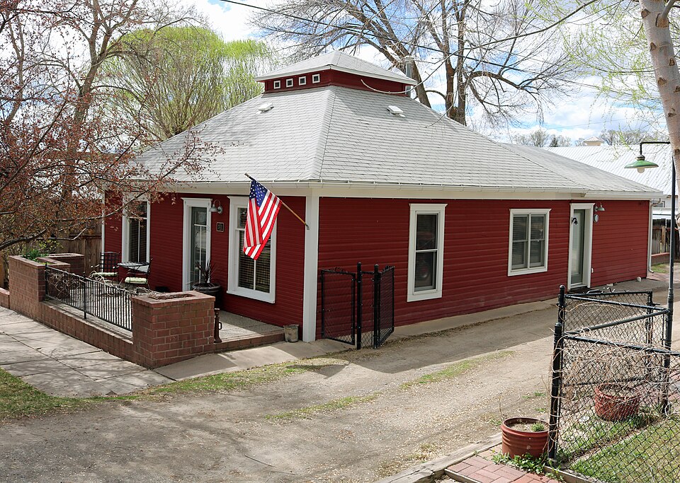
Listed on the National Register of Historic Places in 2013.
One of 20 National Register listings published here for Garfield County · listed in 2013 · category: Building.
Sources: the National Register database, National Park Service
Regional context, not property-specific evidence. The federal wildfire occurrence database lists 192 fires within 5 miles of John Herbert Nunns House between 1992 and 2020, burning about 1,074 acres in total. 101 started naturally. None was recorded as arson. Distance is straight-line from the map coordinates, so a fire counted here may appear on a neighbouring settlement's page as well.
| Reported cause | Fires |
|---|---|
| Natural | 101 |
| Missing data/not specified/undetermined | 70 |
| Debris and open burning | 8 |
| Recreation and ceremony | 7 |
| Equipment and vehicle use | 2 |
| Firearms and explosives use | 2 |
| Railroad operations and maintenance | 1 |
| Smoking | 1 |
The most recent of them, most recent first, with the day each was reported and the service that recorded it.
| Date | Cause | Size | Reported by | Name on the report |
|---|---|---|---|---|
| 9 September 2000 | Natural | under an acre | Northwest District, Grand Junction | GFX ASSIST 20 |
| 7 September 1993 | Natural | under an acre | Northwest District, Grand Junction | GARFIELD C |
| 6 September 2001 | Natural | under an acre | Northwest District, Grand Junction | SLAUGHTER |
| 5 September 2018 | Missing data/not specified/undetermined | under an acre | Colorado River Fire Rescue | UNKNOWN |
| 4 September 2010 | Missing data/not specified/undetermined | 1.0 acres | Northwest District, Grand Junction | GFX ASSIST 429 |
| 27 September 2002 | Natural | under an acre | Northwest District, Grand Junction | MINEOTA |
| 23 September 2011 | Missing data/not specified/undetermined | under an acre | Colorado State Forest Service-State Headquarters | SILT |
| 2 September 2009 | Missing data/not specified/undetermined | under an acre | Northwest District, Grand Junction | GFX ASSIST 475 |
Regional context, not property-specific evidence. The federal mineral resources record lists 3 workings within 5 miles of John Herbert Nunns House: 1 unknown, 1 producer, 1 past producer. 1 still produces. What was taken out: Sand and Gravel, Construction. Distance is straight-line from the map coordinates, so a quarry counted here may appear on a neighbouring settlement's page as well.
| Where | Site | Commodity | Status | Recorded |
|---|---|---|---|---|
| Rifle Pit | Sand and Gravel, Construction | Producer | ||
| Unknown Gravel Pit | Sand and Gravel, Construction | Unknown | ||
| Unknown Gravel Pit | Sand and Gravel, Construction | Past Producer |
Regional context, not property-specific evidence. The National Weather Service names Silt, the town this property stands in, in 18 storm reports between 1997 and 2019: 4 flash flood, 4 heavy rain, 3 hail, 2 wildfire. The reports record 1 death. Each account below is quoted exactly as the forecast office filed it, from the NOAA Storm Events Database, and each date opens the federal record of that event.
| When | Event | Place named | Harm | What the report says |
|---|---|---|---|---|
| July 1997 | Flash Flood | Silt | 1 killed, $150,000 | no account filed |
| July 2019 | Flood | Silt | $5,000 | The northbound lane of Colorado State Highway 325 was closed for an extended period of time about 2 miles north of Rifle Gap Reservoir between Rifle Gap and Rifle Falls State Park due to a partial collapse of the roadway. The collapse was the result of excessive runoff from snow melt and the accumulation of underground water. |
| July 2016 | Flash Flood | Silt | $100 | A small segment of Highway 325 in Rifle Falls State Park was washed out by a flash flood caused by heavy rainfall. |
| September 2019 | Hail | Silt | - | A severe thunderstorm produced large hail the size of quarters east of Silt. |
| October 2018 | Thunderstorm Wind | Silt | - | A trained weather spotter's anemometer recorded a peak wind gust of 61 MPH. |
| October 2018 | Thunderstorm Wind | Silt | - | An automated weather station 1 mile west-southwest of Silt recorded a peak wind gust of 67 MPH. |
| August 2017 | Debris Flow | Silt | - | Heavy rainfall resulted in a large quantity of mud and vegetation which flowed down a drainage and covered Highway 325 between mile markers 5.5 and 5.7. The highway was closed for about 30 minutes until road crews were able to clear the pavement. |
| July 2016 | Flash Flood | Silt | - | Heavy rainfall over a burn scar area resulted in fast moving water and debris up to a foot deep across Highway 325. The flash flood deposited mud, rocks, and debris about a half foot deep along a 110 foot stretch of the highway. The highway was closed for over three hours due to the flash flooding and the post-flood debris removal. |
| July 2013 | Flash Flood | Silt | - | Highway 325 was closed for a while near Rifle Gap Reservoir as 6 to 12 inches of water and mud flowed across the road. |
| June 2010 | Hail | Silt | - | Hail up to 1.0 inch in diameter was reported 1 mile east of Silt. |
| September 2007 | Heavy Rain | Silt | - | About a foot of water was standing on Highway 6 just east of Silt. |
| September 2007 | Heavy Rain | Silt | - | One inch of rain fell in 15 minutes. |
| July 2007 | Hail | Silt | - | no account filed |
| July 2006 | Heavy Rain | Silt | - | no account filed |
| July 2006 | Heavy Rain | Silt | - | no account filed |
| September 2002 | Flood | Silt | - | no account filed |
| October 2001 | Wildfire | Silt | - | no account filed |
| September 2001 | Wildfire | Silt | - | no account filed |
No historic map-sheet match is published for this property yet. That does not mean no map exists. This record needs a coordinate-quality review before it can be joined to a sheet boundary. Browse the county's mapped places while that work is pending.
Other National Register properties close enough to walk or drive between, ordered by distance from this one. Both positions come from the same geocoding pass that matched these properties to their map sheets.
| Photograph | Property | Distance | Listed |
|---|---|---|---|
 | Rifle Bridge | 6.8 miles | 1985 |
 | US Post Office-Rifle Main | 6.9 miles | 1986 |
| National Archives record | The nomination case file for reference 13000871 in Record Group 79. |
| Garfield County | All 20 listed properties in this county. |