 Block
From the record
One of 7 National Register listings published here for Rio Blanco County · listed in 2014 · category: Building.
Sources: the National Register database, National Park Service
Listed on the National Register of Historic Places in 2014.
One of 7 National Register listings published here for Rio Blanco County · listed in 2014 · category: Building.
Sources: the National Register database, National Park Service
Regional context, not property-specific evidence. The federal wildfire occurrence database lists 42 fires within 5 miles of Coal Creek School between 1996 and 2020, burning about 452 acres in total. 18 started naturally. None was recorded as arson. Distance is straight-line from the map coordinates, so a fire counted here may appear on a neighbouring settlement's page as well.
| Reported cause | Fires |
|---|---|
| Missing data/not specified/undetermined | 18 |
| Natural | 18 |
| Equipment and vehicle use | 3 |
| Smoking | 2 |
| Other causes | 1 |
The most recent of them, most recent first, with the day each was reported and the service that recorded it.
| Date | Cause | Size | Reported by | Name on the report |
|---|---|---|---|---|
| 5 September 2020 | Natural | 2.0 acres | Rio Blanco County | COUNTY ROAD 8 |
| 30 September 2018 | Equipment and vehicle use | 4.0 acres | Northwest District, Craig | THIRTEEN |
| 6 August 2010 | Natural | under an acre | Northwest District, Craig | OAK RIDGE |
| 6 August 2010 | Natural | under an acre | Northwest District, Craig | BLUE DEVIL |
| 31 August 2018 | Natural | 5.0 acres | Rio Blanco County | UNKNOWN |
| 30 August 2005 | Missing data/not specified/undetermined | under an acre | Colorado State Forest Service-State Headquarters | not named |
| 25 August 2005 | Missing data/not specified/undetermined | under an acre | Colorado State Forest Service-State Headquarters | not named |
| 13 August 2005 | Missing data/not specified/undetermined | under an acre | Colorado State Forest Service-State Headquarters | not named |
Regional context, not property-specific evidence. The federal mineral resources record lists 12 workings within 5 miles of Coal Creek School: 7 unknowns, 4 occurrences, 1 past producer. None of them still produces. What was taken out: Sand and Gravel, Construction, Gypsum-Anhydrite, Sand and Gravel, Construction, Coal. Distance is straight-line from the map coordinates, so a quarry counted here may appear on a neighbouring settlement's page as well.
| Where | Site | Commodity | Status | Recorded |
|---|---|---|---|---|
| Unknown | Gypsum-Anhydrite | Occurrence | Sedimentary | |
| Unknown | Sand and Gravel, Construction, Coal | Occurrence | Sedimentary | |
| Bloomfield Pit | Sand and Gravel, Construction | Past Producer | ||
| Unknown | Sand and Gravel, Construction | Occurrence | Sand | |
| Unknown | Sand and Gravel, Construction | Occurrence | Gravel | |
| Unknown Gravel Pit | Sand and Gravel, Construction | Unknown | ||
| Unknown Gravel Pit | Sand and Gravel, Construction | Unknown | ||
| Unknown Gravel Pit | Sand and Gravel, Construction | Unknown | ||
| Unknown Gravel Pit | Sand and Gravel, Construction | Unknown | ||
| Unknown Gravel Pit | Sand and Gravel, Construction | Unknown |
Regional context, not property-specific evidence. The National Weather Service names Meeker, the town this property stands in, in 61 storm reports between 1996 and 2025: 18 wildfire, 14 debris flow, 7 thunderstorm wind, 7 flash flood. The reports record 1 death and 1 injury. Each account below is quoted exactly as the forecast office filed it, from the NOAA Storm Events Database, and each date opens the federal record of that event.
| When | Event | Place named | Harm | What the report says |
|---|---|---|---|---|
| August 1998 | Lightning | Meeker | 1 killed, 1 hurt | no account filed |
| June 2006 | Tornado (F1) | Meeker | $35,000 | no account filed |
| September 2025 | Debris Flow | Meeker | $30,000 | Law Enforcement reported water and debris clogging a culvert at Mile Marker 1.3 on Rio Blanco County Route 33. The road was considered impassable and required clearing. Clean up crews responded to the area at 9AM the following day (September 23rd, 2025), with the road cleared by the end of the day. This area is adjacent to the Lee Burn Scar. |
| June 2002 | Hail | Meeker | $25,000 | no account filed |
| June 2004 | Flash Flood | Meeker | $8,000 | no account filed |
| September 2025 | Debris Flow | Meeker | $5,000 | Law Enforcement reported mud over State Highway 64 near Mile Marker 65. This area is near the Lee Burn Scar, which received several rounds of heavy rain during this event. CDOT was contacted to clear the roadway. |
| September 2025 | Debris Flow | Meeker | $5,000 | Law Enforcement reported a debris flow that closed County Road 5 due to heavy rain on the recent Lee Burn Scar. |
| September 2025 | Debris Flow | Meeker | $5,000 | Law Enforcement reported debris and mud closing both lanes of State Highway 13 at Mile Marker 36. Road had to be cleared before being able to be reopened. |
| September 2025 | Debris Flow | Meeker | $5,000 | Public reported mudslides near the intersection of Rio Blanco County Route 5 and Rio Blanco County Route 76. LSR reads Debris flow and flooding of Piceance Creek at County Road 76 and County Road 5. This area is within the Lee Burn Scar. Road had to be cleared. |
| July 2007 | Thunderstorm Wind | Meeker | $5,000 | A thunderstorm wind gust tore some siding from houses in Meeker. |
| July 1996 | Flash Flood | Meeker | $2,000 | no account filed |
| August 2016 | Debris Flow | Meeker | $100 | Heavy rainfall resulted in a mudslide across County Road 76. |
| August 2025 | Debris Flow | Meeker | - | At approximately 5:30 PM MDT, the Boulder Service Hydrologist reported a debris flow south of the Lee Burn Scar flowing over Highway 64 between mile-marker 65 and mile-marker 66. This is in the lower Powell Park area. This region is known for debris flows, but this particular event was enhanced by flow off the adjacent burn scar. However, no damages, injuries, or fatalities were reported. |
| August 2025 | Flash Flood | Meeker | - | A video of flash flooding within a local area known as Josephine Basin, west of Meeker, was sent to NWS Grand Junction via Facebook. This flash flooding began within the Lee Burn Scar, and washed down over Rio Blanco County Road 33. This flooding was not reported to have caused significant damage, but did prevent residents living along County Road 33 from getting to or from their homes until the water retreated. |
| August 2025 | Debris Flow | Meeker | - | The NWS Incident Meteorologist deployed to the Lee Fire reported this event to NWS Grand Junction. Thunderstorms produced heavy rain over the Lee Burn Scar on the afternoon of August 28th. This in turn resulted in water, mud, and debris flowing over Rio Blanco County Road 5 near mile marker 30, roughly 20 miles west of meeker and on the west side of the Lee Burn Scar. A Flash Flood Warning had been issued for this region with 30 minutes of lead time. No reports of damages, injuries, or fatalities were received. County Road 5 did have to be closed for a short duration to clear the debris. |
| August 2025 | Debris Flow | Meeker | - | Heavy rain on the Lee Burn Scar led to debris flows that filled culverts along Highway 13, particularly at the intersection of Rio Blanco County Road 33. This led to flooding of fields and ranches in the Josephine Basin region, just south and west of Meeker. Some debris was also noted along the side of both County Road 33 and Highway 13. |
| August 2024 | Debris Flow | Meeker | - | Heavy rain from a thunderstorm caused a mudslide on Highway 64 at mile marker 57, approximately 17 miles west of Meeker. |
| August 2024 | Debris Flow | Meeker | - | Colorado Department of Transportation reported Colorado State Highway 64 closed at mile marker 56, between Wray Gulch Road and Indian Valley, due to a mudslide. This was just north of White River City, or 18 miles west of the town of Meeker along Highway 64. The road remained closed for several hours while cleanup was undertaken. This stretch of Highway 64 runs along the base of a steep cliff, leaving it prone to debris and mudflows during intense, heavy rainfall events. |
| June 2024 | Debris Flow | Meeker | - | Heavy rain caused a mudslide across Highway 64 at mile marker 65 over Rio Blanco County, 11 miles west-southwest of Meeker. |
| June 2024 | Hail | Meeker | - | Report received of penny size hail 8 miles south-southwest of Meeker. Video of Highway 13 shows the road covered in hail after the storm moved through. |
| October 2018 | Debris Flow | Meeker | - | Mud and rocks were deposited onto Colorado Highway 64 between Meeker and Rangely as a result of heavy rainfall on already saturated soils. |
| July 2014 | Flash Flood | Meeker | - | Up to six inches of fast moving water ran across Highway 64 west of Meeker. |
| July 2013 | Debris Flow | Meeker | - | Four separate mud slides were reported near mile marker 60 on Highway 64. |
| July 2011 | Flash Flood | Meeker | - | Flash flood waters up to a foot deep deposited mud and rocks onto Highway 64 which was closed until crews cleared the road of debris. |
| January 2010 | Flood | Meeker | - | An ice jam along the White River caused water to backup in the Meeker area, resulting in areas of minor flooding. Cold overnight temperatures also contributed to the continuation of ice build-up. Areas in the park below the 10th Street bridge were affected, and rising water also threatened several homes in neighborhoods along 8th and 9th Streets. |
| January 2007 | Flood | Meeker | - | Lowland flooding occurred in the Meeker area along the White River. Minor flooding was reported in the Stagecoach Trailer Park near the intersection of Highways 13 and 64. Residents from 18 of the 20 trailer homes had to be evacuated. Some agricultural land, including a corral, were also flooded. |
| September 2007 | Hail | Meeker | - | Hail from penny-size to quarter-size in diameter occurred in Meeker. |
| September 2007 | Flash Flood | Meeker | - | Runoff from heavy rain producing thunderstorms caused mud and debris to flow across Highway 64 in 4 different locations 10 to 12 miles west of Meeker. Mud, rocks, trees, and other vegetation were deposited on the roadway, up to 4 feet deep in places. Some of the rocks were 3 to 4 feet in diameter. Many culverts along the highway became plugged with debris. Two semi trucks became stuck in the debris. |
| May 2006 | Thunderstorm Wind | Meeker | - | no account filed |
| May 2006 | Thunderstorm Wind | Meeker | - | no account filed |
| June 2004 | Thunderstorm Wind | Meeker | - | no account filed |
| July 2003 | Wildfire | Meeker | - | no account filed |
| July 2003 | Wildfire | Meeker | - | no account filed |
| August 2003 | Wildfire | Meeker | - | no account filed |
| September 2002 | Wildfire | Meeker | - | no account filed |
| September 2002 | Thunderstorm Wind | Meeker | - | no account filed |
| September 2002 | Flood | Meeker | - | no account filed |
| July 2002 | Wildfire | Meeker | - | no account filed |
| August 2002 | Flood | Meeker | - | no account filed |
| August 2002 | Wildfire | Meeker | - | no account filed |
| June 2001 | Wildfire | Meeker | - | no account filed |
| July 2001 | Flash Flood | Meeker | - | no account filed |
| July 2001 | Flood | Meeker | - | no account filed |
| July 2000 | Wildfire | Meeker | - | no account filed |
| July 2000 | Wildfire | Meeker | - | no account filed |
| July 2000 | Wildfire | Meeker | - | no account filed |
| July 2000 | Wildfire | Meeker | - | no account filed |
| July 2000 | Wildfire | Meeker | - | no account filed |
| August 2000 | Wildfire | Meeker | - | no account filed |
| June 2000 | Hail | Meeker | - | no account filed |
| July 2000 | Wildfire | Meeker | - | no account filed |
| July 2000 | Wildfire | Meeker | - | no account filed |
| July 2000 | Wildfire | Meeker | - | no account filed |
| August 1999 | Funnel Cloud | Meeker | - | no account filed |
| May 1998 | Wildfire | Meeker | - | no account filed |
| August 1998 | Wildfire | Meeker | - | no account filed |
| September 1997 | Heavy Rain | Meeker | - | no account filed |
| September 1997 | Hail | Meeker | - | no account filed |
| September 1997 | Thunderstorm Wind | Meeker | - | no account filed |
| June 1996 | Thunderstorm Wind | Meeker | - | no account filed |
No historic map-sheet match is published for this property yet. That does not mean no map exists. This record needs a coordinate-quality review before it can be joined to a sheet boundary. Browse the county's mapped places while that work is pending.
Other National Register properties close enough to walk or drive between, ordered by distance from this one. Both positions come from the same geocoding pass that matched these properties to their map sheets.
| Photograph | Property | Distance | Listed |
|---|---|---|---|
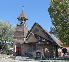 | St. James Episcopal Church | 5.0 miles | 1978 |
 | Meeker I.O.O.F. Lodge-Valentine Lodge No. 47 | 5.0 miles | 2014 |
 | Hotel Meeker | 5.1 miles | 1980 |
 | Meeker Historic District | 5.1 miles | 2019 |
| National Archives record | The nomination case file for reference 14000421 in Record Group 79. |
| Rio Blanco County | All 7 listed properties in this county. |