 Block
From the record
7 National Register listings published here.
Sources: the National Register database, National Park Service
64 topographic sheets cover 7 settlements here, and 7 properties are on the National Register of Historic Places.
7 National Register listings published here.
Sources: the National Register database, National Park Service
Every property in this county listed on the National Register of Historic Places, with the year it was listed and the federal nomination document.
| Photograph | Property | Type | Listed | Reference |
|---|---|---|---|---|
| Coal Creek School | building | 2014 | 14000421 | |
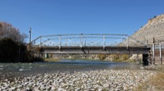 | Hay's Ranch Bridge | structure | 1985 | 85000233 |
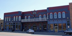 | Hotel Meeker | building | 1980 | 80000923 |
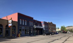 | Meeker Historic District | district | 2019 | 100003359 |
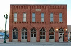 | Meeker I.O.O.F. Lodge-Valentine Lodge No. 47 | building | 2014 | 14000060 |
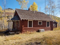 | Pyramid Guard Station | district | 2008 | 07001354 |
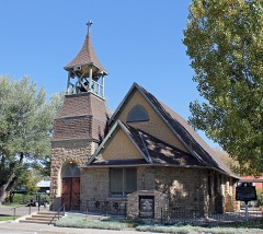 | St. James Episcopal Church | building | 1978 | 78000883 |
Every wildfire the federal occurrence database records inside this county: 3,400 of them, burning about 134,168 acres. 3,033 started naturally and 5 were recorded as arson. Each settlement page carries the fires within five miles of it.
| Reported cause | Fires |
|---|---|
| Natural | 3033 |
| Missing data/not specified/undetermined | 184 |
| Debris and open burning | 55 |
| Equipment and vehicle use | 42 |
| Recreation and ceremony | 31 |
| Smoking | 28 |
| Power generation/transmission/distribution | 15 |
| Arson/incendiarism | 5 |
| Fireworks | 3 |
| Misuse of fire by a minor | 2 |
| Firearms and explosives use | 1 |
| Other causes | 1 |
The five largest, by the area the report gives. None of them was recorded as arson.
| Date | Cause | Size | Reported by | Name on the report |
|---|---|---|---|---|
| 11 June 2017 | Recreation and ceremony | 18,804 acres | Northwest District, Craig | DEAD DOG |
| 6 June 2004 | Natural | 7,815 acres | Northwest District, Craig | GREASEWOOD |
| 20 July 2018 | Natural | 6,310 acres | Northwest District, Craig | INDIAN VALLEY |
| 29 July 2018 | Natural | 5,967 acres | White River National Forest | CABIN LAKE |
| 29 July 2018 | Natural | 5,722 acres | Northwest District, Craig | RED CANYON |
| 13 July 2002 | Natural | 5,538 acres | Medicine Bow-Routt National Forests, Thunder Basin National Grassland | LOST LAKES |
| 8 August 2016 | Natural | 4,417 acres | White River National Forest | LOST SOLAR |
| 22 July 2000 | Natural | 4,030 acres | Northwest District, Craig | SCANDARD |
Every settlement page carries the fires within five miles of it - see the settlement index below.
The NOAA Storm Events Database holds 174 reports for this county, causing 1 death, 10 injuries and about $1,722,850 in recorded property damage. Each settlement page carries the reports that name it.
| Kind of event | Reports |
|---|---|
| Thunderstorm Wind | 43 |
| Flash Flood | 33 |
| Wildfire | 30 |
| Debris Flow | 25 |
| Heavy Rain | 14 |
| Hail | 11 |
| Funnel Cloud | 7 |
| Flood | 6 |
| Tornado | 3 |
| Lightning | 2 |
The most serious of them, by death, then injury, then recorded damage. The accounts are quoted exactly as the forecast office filed them.
| When | Event | Place named | Harm | What the report says |
|---|---|---|---|---|
| August 1998 | Lightning | Meeker | 1 killed, 1 hurt | no account filed |
| July 2005 | Flash Flood | Rio Blanco | 5 hurt, $80,000 | no account filed |
| June 2009 | Lightning | Rangely Arpt | 4 hurt, $250 | Four men were golfing on the seventh green at the Cedar Ridges Golf Course in Rangely when a tree 15 to 20 yards away was struck by lightning. The charge from the lightning bolt traveled from the tree through the ground and struck the four golfers, blowing the golf clubs out of their hands and leaving them stunned for a period of time. They heard popping noises on the tops of their heads as the charge exited through their caps. One of the golfers felt like the hair on his head was on fire. The tree struck by lightning was split open and a large amount of bark was blown off. Information in this report was provided by one of the lightning strike victims. |
| September 1997 | Hail | Rangely | $1,000,000 | no account filed |
| July 2019 | Flash Flood | Rangely Arpt | $200,000 | Rally car racers encountered flooding along County Road 73 near Hall Draw when their vehicle stalled. Drivers escaped the vehicle before it was swept downstream toward the White River. The vehicle was later found approximately 1 mile downstream from where it got swept off the road. |
| September 1997 | Thunderstorm Wind | Rangely | $150,000 | no account filed |
| June 2011 | Thunderstorm Wind | Rangely | $100,000 | A microburst initially struck the ground about a quarter mile southwest of the Northwest Colorado Community College Campus and spread out generally to the northeast from that point. A significant portion of a roof on North Nichols Residence Hall was lifted up and blown completely over the structure. Debris from North Nichols Residence Hall was found up to a quarter mile away on the northeast end of the campus. A dozen mature Russian Olive trees on the campus were uprooted, and large limbs and branches were snapped off many other trees. One of the uprooted trees fell against the CNCC presidents house, causing some damage to the roof. Other wind damage to property on the CNCC campus was observed during the NWS storm survey. Further away from the CNCC campus, additional wind damage also occurred, although it was generally a little less destructive than the CNCC damage, with estimated wind gusts ranging from 55 to 70 mph. There was an observed wind speed measurement of 54 knots (62 mph) from the AWOS at the Rangely Airport (4V0) where a section of wooden fence was blown down and a swamp cooler blown from the roof of the terminal. Many trees within the town of Rangely were uprooted or lost large limbs or branches. A few trees were snapped off a few feet above the ground, including ash trees with trunk bases generally ranging from 6 to 10 inches in diameter. A wood frame carport was ripped off an apartment building on East Main Street. A large trampoline in the northeast part of Rangely was blown into the air and landed about 75 yards away in a neighbors yard, while a 400 pound water tank was blown across a road. |
| June 2006 | Tornado (F1) | Meeker | $35,000 | no account filed |
| September 2025 | Debris Flow | Meeker | $30,000 | Law Enforcement reported water and debris clogging a culvert at Mile Marker 1.3 on Rio Blanco County Route 33. The road was considered impassable and required clearing. Clean up crews responded to the area at 9AM the following day (September 23rd, 2025), with the road cleared by the end of the day. This area is adjacent to the Lee Burn Scar. |
| June 2002 | Hail | Meeker | $25,000 | no account filed |
| July 2005 | Flash Flood | Rio Blanco | $20,000 | no account filed |
| July 1996 | Flash Flood | Rio Blanco | $12,000 | no account filed |
| August 2009 | Hail | Rangely | $10,000 | Golf ball sized hail struck the town of Rangely. Minor damage was reported, including shingle damage, dents in cars and a few broken windows. |
| June 2004 | Flash Flood | Meeker | $8,000 | no account filed |
| September 2025 | Debris Flow | Meeker | $5,000 | Law Enforcement reported mud over State Highway 64 near Mile Marker 65. This area is near the Lee Burn Scar, which received several rounds of heavy rain during this event. CDOT was contacted to clear the roadway. |
| September 2025 | Debris Flow | Buford | $5,000 | Law Enforcement reported mud and debris on State Route 8 due to heavy rain on the recent Elk RBX Burn Scar. No reports of damages, injuries, or fatalities, just clearing of the roadway. |
| September 2025 | Debris Flow | Meeker | $5,000 | Law Enforcement reported a debris flow that closed County Road 5 due to heavy rain on the recent Lee Burn Scar. |
| September 2025 | Debris Flow | Meeker | $5,000 | Law Enforcement reported debris and mud closing both lanes of State Highway 13 at Mile Marker 36. Road had to be cleared before being able to be reopened. |
| September 2025 | Debris Flow | Meeker | $5,000 | Public reported mudslides near the intersection of Rio Blanco County Route 5 and Rio Blanco County Route 76. LSR reads Debris flow and flooding of Piceance Creek at County Road 76 and County Road 5. This area is within the Lee Burn Scar. Road had to be cleared. |
| September 2025 | Debris Flow | Rio Blanco | $5,000 | Law Enforcement reported a mudslide at Mile Marker 1.5 on Rio Blanco County Route 5, closing the road and requiring clearing. The debris was cleared within half an hour. This area is within the Lee Burn Scar. |
| August 2009 | Flash Flood | Rio Blanco | $5,000 | Flash flood waters flowed across Rio Blanco County Road 5 in several places with water over a foot deep in some spots. A large mudslide came down across the road near mile marker 18. It took two days to move mud and debris off and away from the road and to make repairs. Additionally, major soil erosion was reported on some privately owned ranch and farmland in the basin. |
| July 2007 | Thunderstorm Wind | Meeker | $5,000 | A thunderstorm wind gust tore some siding from houses in Meeker. |
| September 1997 | Flash Flood | Rangely | $3,000 | no account filed |
| July 1957 | Tornado | not stated | $2,500 | no account filed |
| September 1997 | Flash Flood | Rangely | $2,000 | no account filed |
| July 1996 | Flash Flood | Meeker | $2,000 | no account filed |
| July 2022 | Debris Flow | Rio Blanco | $1,500 | A mudslide occurred along County Road 5 near mile marker 12 near Piceance Creek as a result of heavy rain from thunderstorms. |
| August 1997 | Flash Flood | Rangely | $1,000 | no account filed |
| May 1994 | Thunderstorm Wind | Rangely | $500 | no account filed |
| August 2016 | Debris Flow | Meeker | $100 | Heavy rainfall resulted in a mudslide across County Road 76. |
| August 2025 | Debris Flow | Rio Blanco | - | This incident was reported to the NWS Grand Junction office by the NWS Incident Meteorologist assigned to the Lee Wildfire. Debris flowed across County Road 5 from due to heavy rain on the adjacent Lee burn scar. A tractor trailer attempted to drive through the debris flow and became stuck. The truck was eventually unstuck and the road was cleared. No damages or injuries or fatalities were reported. |
| August 2025 | Debris Flow | Meeker | - | At approximately 5:30 PM MDT, the Boulder Service Hydrologist reported a debris flow south of the Lee Burn Scar flowing over Highway 64 between mile-marker 65 and mile-marker 66. This is in the lower Powell Park area. This region is known for debris flows, but this particular event was enhanced by flow off the adjacent burn scar. However, no damages, injuries, or fatalities were reported. |
| August 2025 | Flash Flood | Meeker | - | A video of flash flooding within a local area known as Josephine Basin, west of Meeker, was sent to NWS Grand Junction via Facebook. This flash flooding began within the Lee Burn Scar, and washed down over Rio Blanco County Road 33. This flooding was not reported to have caused significant damage, but did prevent residents living along County Road 33 from getting to or from their homes until the water retreated. |
| August 2025 | Debris Flow | Rio Blanco | - | The NWS Incident Meteorologist assigned to the Lee Fire reported this event to NWS Grand Junction. Mud and debris were confirmed to be flowing across Rio Blanco County Road 5 at mile marker 6 and mile marker 12, making the road impassable. As a result, County Road 5 was closed from miles marker 12 to the intersection with Highway 13 for roughly half an hour. |
| September 2025 | Thunderstorm Wind | Meeker Arpt | - | At approximately 4:48 PM MDT, the KEEO ASOS at Meeker Airport recorded a gust to 58 mph in association with a nearby thunderstorm. Other gusts in the area ranged from 45 mph to 55 mph. No reports of damages, fatalities, or injuries were received in association with this event. |
| August 2025 | Flash Flood | Rio Blanco | - | This incident was reported to NWS Grand Junction by the NWS Incident Meteorologist deployed to the Lee Wildfire. Water was reported as flowing over Highway 13 adjacent to the Lee Burn Scar, near the incident on County Road 5, and south of the town of Meeker. All of this water drains into the White River, and the gage on the White River below Meeker spiked from roughly 110 cfs to 1660 cfs, with a rise in water height of 3 feet. |
| August 2025 | Debris Flow | Meeker | - | The NWS Incident Meteorologist deployed to the Lee Fire reported this event to NWS Grand Junction. Thunderstorms produced heavy rain over the Lee Burn Scar on the afternoon of August 28th. This in turn resulted in water, mud, and debris flowing over Rio Blanco County Road 5 near mile marker 30, roughly 20 miles west of meeker and on the west side of the Lee Burn Scar. A Flash Flood Warning had been issued for this region with 30 minutes of lead time. No reports of damages, injuries, or fatalities were received. County Road 5 did have to be closed for a short duration to clear the debris. |
| August 2025 | Debris Flow | Meeker Arpt | - | At approximately 12:15PM MDT, the Rio Blanco Emergency Manager reported a debris flow over County Road 8 between mile-markers 10 and 11. This debris flow was the result of heavy rainfall on the recent Elk RBX burn scar, which was adjacent to the road. Road did need to be cleared, but was already closed to public traffic due to the ongoing Elk RBX fire. No additional damage, or injuries or fatalities were reported. |
| August 2025 | Debris Flow | Rio Blanco | - | At approximately 1:18 PM MDT, a report reached NWS Grand Junction that heavy rain over the Lee Burn Scar had triggered a debris flow over Rio Blanco County Road 5 in the same area that had run on August 24th. This time, no vehicles were trapped and no other damage occurred, nor were any injuries or fatalities reported. |
| August 2025 | Debris Flow | Meeker | - | Heavy rain on the Lee Burn Scar led to debris flows that filled culverts along Highway 13, particularly at the intersection of Rio Blanco County Road 33. This led to flooding of fields and ranches in the Josephine Basin region, just south and west of Meeker. Some debris was also noted along the side of both County Road 33 and Highway 13. |
| October 2025 | Debris Flow | Rangely | - | Heavy rain resulted in a rock slide on Douglas Pass along Highway 139 at mile marker 33, 29 miles north of Loma, Colorado. Highway 139 closed at 531 MST. |
| August 2024 | Debris Flow | Meeker | - | Heavy rain from a thunderstorm caused a mudslide on Highway 64 at mile marker 57, approximately 17 miles west of Meeker. |
| August 2024 | Debris Flow | Meeker | - | Colorado Department of Transportation reported Colorado State Highway 64 closed at mile marker 56, between Wray Gulch Road and Indian Valley, due to a mudslide. This was just north of White River City, or 18 miles west of the town of Meeker along Highway 64. The road remained closed for several hours while cleanup was undertaken. This stretch of Highway 64 runs along the base of a steep cliff, leaving it prone to debris and mudflows during intense, heavy rainfall events. |
| July 2024 | Thunderstorm Wind | Meeker Arpt | - | A round of showers and thunderstorms tracked across central Rio Blanco county, producing wind gusts ranging from 45 to 60 mph. The peak recorded gust was 58 mph, and this was recorded at KEEO ASOS, located at Meeker Airport. No reports of damages or injuries were received. |
| June 2024 | Debris Flow | Meeker | - | Heavy rain caused a mudslide across Highway 64 at mile marker 65 over Rio Blanco County, 11 miles west-southwest of Meeker. |
| September 2024 | Thunderstorm Wind | Meeker Arpt | - | A thunderstorm wind gust of 59 mph was measured at the Meeker Coulter Field Airport at 823 MST. |
| June 2024 | Hail | Meeker | - | Report received of penny size hail 8 miles south-southwest of Meeker. Video of Highway 13 shows the road covered in hail after the storm moved through. |
| May 2023 | Hail | Rangely | - | Hail estimated to be one inch in diameter fell near Rangely. |
| August 2023 | Thunderstorm Wind | Rangely Arpt | - | A peak wind gust of 63 MPH was measured by an automated weather station 18 miles southeast of Massadona. |
| June 2022 | Thunderstorm Wind | Meeker Arpt | - | A peak wind gust of 64 MPH was measured by the automated weather station at the Meeker Coulter Field Airport. |
| July 2022 | Thunderstorm Wind | Meeker Arpt | - | A peak wind gust of 61 MPH was measured by the automated weather station at the Meeker Coulter Field Airport. |
| September 2021 | Thunderstorm Wind | Rangely Arpt | - | A peak wind gust of 65 MPH was measured by the Pinto automated weather station 18 miles southeast of Massadona. |
| September 2021 | Thunderstorm Wind | Meeker Arpt | - | A peak wind gust of 75 MPH was measured by the automated weather station at the Meeker-Coulter Field Airport. |
| August 2021 | Thunderstorm Wind | Meeker Arpt | - | A peak wind gust of 58 MPH was measured by the automated weather station at the Meeker Coulter Field Airport. |
| May 2020 | Hail | Rio Blanco | - | A severe thunderstorm produced large hail estimated to be the size of quarters southwest of Meeker. |
| July 2020 | Thunderstorm Wind | Meeker Arpt | - | A peak wind gust of 66 mph was measured by the automated weather station at the Meeker Coulter Field Airport. |
| June 2020 | Thunderstorm Wind | Rangely | - | A peak wind gust of 58 mph was measured by the Dragon Road automated weather station. |
| June 2020 | Thunderstorm Wind | Meeker Arpt | - | A peak wind gust of 69 mph was measured by the automated weather station at the Meeker Coulter Field Airport. |
| June 2020 | Thunderstorm Wind | Buford | - | A peak wind gust of 86 mph was measured by the Dead Horse automated weather station. |
| June 2020 | Thunderstorm Wind | Rangely Arpt | - | A peak wind gust of 65 mph was measured by the automated weather station at the Pinto RAWS site. |
The Survey's mineral resources record lists 126 workings inside this county. 8 still produce and 118 are closed or unrecorded. Each settlement page carries the workings within five miles of it.
| Commodity | Workings |
|---|---|
| Sand and Gravel, Construction | 65 |
| Fire Clay (Refractory) | 17 |
| Uranium, Vanadium | 15 |
| Uranium | 7 |
| Zeolites | 7 |
| Gypsum-Anhydrite | 6 |
| Vanadium, Uranium | 3 |
| Vanadium | 2 |
| Calcium, Sodium | 1 |
| Aluminum, Halite | 1 |
| Stone, Crushed/Broken | 1 |
| Stone, Crushed/Broken, Petroleum (Oil) | 1 |
| Sand and Gravel, Construction, Coal | 1 |
| Uranium, Vanadium, Copper | 1 |
The least common of them first, because a county's hundredth gravel pit says nothing its first ten did not.
| Where | Site | Commodity | Status | Recorded |
|---|---|---|---|---|
| Caywood #1, #2 | Uranium, Vanadium, Copper | Occurrence | Carnotite | |
| Piceance Creek Basin Saline Deposits | Calcium, Sodium, Aluminum, Halite | Producer | 1947 | |
| Unknown | Stone, Crushed/Broken | Occurrence | Sedimentary | |
| Unknown | Stone, Crushed/Broken, Petroleum (Oil) | Occurrence | Sedimentary | |
| Unknown | Sand and Gravel, Construction, Coal | Occurrence | Sedimentary | |
| Unnamed Gold Prospect | Gold | Occurrence | ||
| Butterfly | Uranium, Vanadium | Past Producer | ||
| Midnight | Uranium, Vanadium | Producer | ||
| Brown Group | Vanadium, Uranium | Past Producer | ||
| Butterfly Group | Vanadium, Uranium | Producer | Carnotite, Tyuyamunite | |
| Unknown | Vanadium, Uranium | Producer | ||
| Unknown | Gypsum-Anhydrite | Occurrence | Sedimentary | |
| Unknown | Gypsum-Anhydrite | Occurrence | Sedimentary | |
| Unknown | Gypsum-Anhydrite | Occurrence | Sedimentary | |
| Unknown | Gypsum-Anhydrite | Occurrence | Sedimentary | |
| Unknown | Gypsum-Anhydrite | Occurrence | Sedimentary | |
| Unknown | Gypsum-Anhydrite | Occurrence | Sedimentary | |
| Cathedral Bluffs | Zeolites | Producer | ||
| Coal Creek No. 1 | Uranium | Past Producer | ||
| Columbine | Uranium | Past Producer | ||
| East Fork | Zeolites | Producer | ||
| Guy Stealy Claims | Uranium | Occurrence | ||
| Iron Bridge | Zeolites | Past Producer | ||
| Shylo No.1 | Uranium | Unknown | ||
| Staley Mine | Zeolites | Past Producer | ||
| Unknown | Zeolites | Occurrence | Analcime | |
| Unknown | Zeolites | Occurrence | Analcime | |
| White River Cliff | Zeolites | Producer | ||
| Windy Point No. 1 | Uranium | Past Producer | ||
| Burrell No. 5 Claim | Uranium, Vanadium | Past Producer | Carnotite, Tyuyamunite | |
| Burrell Nos. 1-3 Claims | Uranium, Vanadium | Past Producer | Carnotite, Tyuyamunite | |
| Coal Creek No. 1 Claim | Uranium, Vanadium | Past Producer | Carnotite, Tyuyamunite | |
| Columbine Nos. 1-4 Claims | Uranium, Vanadium | Past Producer | Carnotite, Tyuyamunite | |
| Guy Stealey Claims | Uranium, Vanadium | Producer | ||
| Jerry Zochol | Uranium, Vanadium | Occurrence | ||
| Last Day Claim | Uranium, Vanadium | Past Producer | Tyuyamunite | |
| Marvine View No. 10 Claim | Uranium, Vanadium | Past Producer | ||
| Meeker | Uranium, Vanadium | Occurrence | ||
| Naomi Ann Claim | Uranium, Vanadium | Past Producer | ||
| Rio Blanco | Uranium, Vanadium | Past Producer | ||
| S & G No. 4 Claim | Uranium, Vanadium | Past Producer | Carnotite, Tyuyamunite | |
| Shylo Group | Uranium, Vanadium | Past Producer | Carnotite, Tyuyamunite | |
| Unknown | Uranium, Vanadium | Occurrence | ||
| Windy Point No. 1 Claim | Uranium, Vanadium | Past Producer | Tyuyamunite | |
| Unknown | Fire Clay (Refractory) | Occurrence | ||
| Unknown | Fire Clay (Refractory) | Occurrence | ||
| Unknown | Fire Clay (Refractory) | Occurrence | ||
| Unknown | Fire Clay (Refractory) | Occurrence | ||
| Unknown | Fire Clay (Refractory) | Occurrence | ||
| Unknown | Fire Clay (Refractory) | Occurrence | ||
| Unknown | Fire Clay (Refractory) | Occurrence | ||
| Unknown | Fire Clay (Refractory) | Occurrence | ||
| Unknown | Fire Clay (Refractory) | Occurrence | ||
| Unknown | Fire Clay (Refractory) | Occurrence | ||
| Unknown | Fire Clay (Refractory) | Occurrence | ||
| Unknown | Fire Clay (Refractory) | Occurrence | ||
| Unknown | Fire Clay (Refractory) | Occurrence | ||
| Unknown | Fire Clay (Refractory) | Occurrence | ||
| Unknown | Fire Clay (Refractory) | Occurrence | ||
| Unknown | Fire Clay (Refractory) | Occurrence | ||
| Unknown | Fire Clay (Refractory) | Occurrence | ||
| Bloomfield Pit | Sand and Gravel, Construction | Past Producer | ||
| Unknown | Sand and Gravel, Construction | Occurrence | Gravel | |
| Unknown | Sand and Gravel, Construction | Occurrence | Gravel | |
| Unknown | Sand and Gravel, Construction | Occurrence | Gravel | |
| Unknown | Sand and Gravel, Construction | Occurrence | Gravel | |
| Unknown | Sand and Gravel, Construction | Occurrence | ||
| Unknown | Sand and Gravel, Construction | Occurrence | Gravel | |
| Unknown | Sand and Gravel, Construction | Occurrence | Gravel | |
| Unknown | Sand and Gravel, Construction | Occurrence | ||
| Unknown | Sand and Gravel, Construction | Occurrence | Gravel | |
| Unknown | Sand and Gravel, Construction | Occurrence | Gravel | |
| Unknown | Sand and Gravel, Construction | Occurrence | Gravel | |
| Unknown | Sand and Gravel, Construction | Occurrence | ||
| Unknown | Sand and Gravel, Construction | Occurrence | Sedimentary | |
| Unknown | Sand and Gravel, Construction | Occurrence | ||
| Unknown | Sand and Gravel, Construction | Occurrence | Gravel | |
| Unknown | Sand and Gravel, Construction | Occurrence | ||
| Unknown | Sand and Gravel, Construction | Occurrence | ||
| Unknown | Sand and Gravel, Construction | Occurrence | Gravel | |
| Unknown | Sand and Gravel, Construction | Occurrence | ||
| Unknown | Sand and Gravel, Construction | Occurrence | Gravel | |
| Unknown | Sand and Gravel, Construction | Occurrence | Gravel | |
| Unknown | Sand and Gravel, Construction | Occurrence | Gravel | |
| Unknown | Sand and Gravel, Construction | Occurrence | Sand | |
| Unknown | Sand and Gravel, Construction | Occurrence | Gravel | |
| Unknown | Sand and Gravel, Construction | Occurrence | ||
| Unknown | Sand and Gravel, Construction | Occurrence | Gravel | |
| Unknown | Sand and Gravel, Construction | Occurrence | Sand | |
| Unknown Gravel Pit | Sand and Gravel, Construction | Unknown | ||
| Unknown Gravel Pit | Sand and Gravel, Construction | Unknown | ||
| Unknown Gravel Pit | Sand and Gravel, Construction | Unknown | ||
| Unknown Gravel Pit | Sand and Gravel, Construction | Unknown | ||
| Unknown Gravel Pit | Sand and Gravel, Construction | Unknown | ||
| Unknown Gravel Pit | Sand and Gravel, Construction | Unknown | ||
| Unknown Gravel Pit | Sand and Gravel, Construction | Unknown | ||
| Unknown Gravel Pit | Sand and Gravel, Construction | Unknown | ||
| Unknown Gravel Pit | Sand and Gravel, Construction | Unknown | ||
| Unknown Gravel Pit | Sand and Gravel, Construction | Unknown | ||
| Unknown Gravel Pit | Sand and Gravel, Construction | Unknown | ||
| Unknown Gravel Pit | Sand and Gravel, Construction | Unknown | ||
| Unknown Gravel Pit | Sand and Gravel, Construction | Unknown | ||
| Unknown Gravel Pit | Sand and Gravel, Construction | Unknown | ||
| Unknown Gravel Pit | Sand and Gravel, Construction | Unknown | ||
| Unknown Gravel Pit | Sand and Gravel, Construction | Unknown | ||
| Unknown Gravel Pit | Sand and Gravel, Construction | Unknown | ||
| Unknown Gravel Pit | Sand and Gravel, Construction | Unknown | ||
| Unknown Gravel Pit | Sand and Gravel, Construction | Unknown | ||
| Unknown Gravel Pit | Sand and Gravel, Construction | Unknown | ||
| Unknown Gravel Pit | Sand and Gravel, Construction | Unknown | ||
| Unknown Gravel Pit | Sand and Gravel, Construction | Unknown | ||
| Unknown Gravel Pit | Sand and Gravel, Construction | Unknown | ||
| Unknown Gravel Pit | Sand and Gravel, Construction | Unknown | ||
| Unknown Gravel Pit | Sand and Gravel, Construction | Unknown | ||
| Unknown Gravel Pit | Sand and Gravel, Construction | Unknown | ||
| Unknown Gravel Pit | Sand and Gravel, Construction | Unknown | ||
| Unknown Gravel Pit | Sand and Gravel, Construction | Unknown | ||
| Unknown Gravel Pit | Sand and Gravel, Construction | Unknown | ||
| Unknown Gravel Pit | Sand and Gravel, Construction | Unknown | ||
| Unknown Gravel Pit | Sand and Gravel, Construction | Unknown | ||
| Unknown Gravel Pit | Sand and Gravel, Construction | Unknown | ||
| Unknown Gravel Pit | Sand and Gravel, Construction | Unknown | ||
| Unknown Gravel Pit | Sand and Gravel, Construction | Unknown | ||
| Unknown Gravel Pit | Sand and Gravel, Construction | Unknown | ||
| Unknown Gravel Pits | Sand and Gravel, Construction | Unknown | ||
| Unknown Sandpit | Sand and Gravel, Construction | Unknown |
Named settlements recorded in the Geographic Names Information System, each with the topographic sheets covering it. Villages, hamlets and abandoned places alike. Each is shown with the nearest named watercourse or landform and the survey quadrangle it falls on.
Rangely census division · 81648 · Near School Gulch · Divide Creek quadrangle
12 sheets, 1907 to 1979
Meeker census division · 81641 · On Gooseberry Creek · Buford quadrangle
17 sheets, 1906 to 1981
Meeker census division · 81641 · On Sulphur Creek · Meeker quadrangle
16 sheets, 1910 to 1979
Rangely census division · 81648 · Near Dead Dog Draw · Rangely quadrangle
14 sheets, 1907 to 1979
Meeker census division · 81641 · Near Oil Well Gulch · White River City quadrangle
11 sheets, 1907 to 1979