 Block
From the record
One of 13 National Register listings published here for Moffat County · listed in 1975 · category: Structure.
Sources: the case file at the National Archives · the National Register database, National Park Service
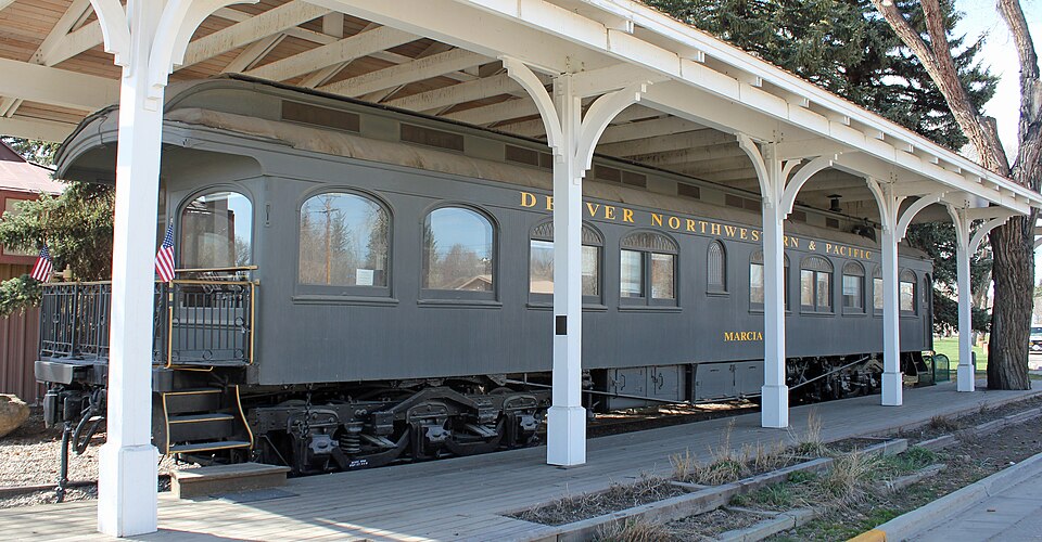
Listed on the National Register of Historic Places in 1975.
One of 13 National Register listings published here for Moffat County · listed in 1975 · category: Structure.
Sources: the case file at the National Archives · the National Register database, National Park Service
Regional context, not property-specific evidence. The federal wildfire occurrence database lists 52 fires within 5 miles of Marcia (pullman car) between 2010 and 2020, burning about 354 acres in total. 7 started naturally. None was recorded as arson. Distance is straight-line from the map coordinates, so a fire counted here may appear on a neighbouring settlement's page as well.
| Reported cause | Fires |
|---|---|
| Missing data/not specified/undetermined | 32 |
| Natural | 7 |
| Equipment and vehicle use | 6 |
| Fireworks | 3 |
| Debris and open burning | 2 |
| Power generation/transmission/distribution | 1 |
| Firearms and explosives use | 1 |
The most recent of them, most recent first, with the day each was reported and the service that recorded it.
| Date | Cause | Size | Reported by | Name on the report |
|---|---|---|---|---|
| 6 September 2018 | Missing data/not specified/undetermined | 5.0 acres | Northwest District, Craig | DOE RUN |
| 3 September 2018 | Missing data/not specified/undetermined | under an acre | Craig Rural Fire Protection District | UNKNOWN |
| 15 September 2015 | Missing data/not specified/undetermined | under an acre | Craig Rural Fire Protection District | UNKNOWN |
| 11 September 2017 | Natural | under an acre | Northwest District, Craig | EMBER |
| 9 August 2011 | Missing data/not specified/undetermined | 300 acres | Colorado State Forest Service-State Headquarters | CRAIG |
| 26 August 2020 | Power generation/transmission/distribution | under an acre | Craig Rural Fire Protection District | N/A |
| 23 August 2015 | Equipment and vehicle use | under an acre | Craig Rural Fire Protection District | UNKNOWN |
| 19 August 2013 | Natural | under an acre | Northwest District, Craig | RETURN |
Regional context, not property-specific evidence. The federal mineral resources record lists 14 workings within 5 miles of Marcia (pullman car): 8 unknowns, 3 past producers, 2 producers, 1 occurrence. 2 still produce. What was taken out: Sand and Gravel, Construction, Uranium, Gold. Distance is straight-line from the map coordinates, so a quarry counted here may appear on a neighbouring settlement's page as well.
| Where | Site | Commodity | Status | Recorded |
|---|---|---|---|---|
| Fortifacation Creek Placers | Gold | Occurrence | Placer | |
| Leon Claims | Uranium | Unknown | ||
| Three Sisters | Uranium | Past Producer | ||
| Craig Pit | Sand and Gravel, Construction | Producer | ||
| Grace Pit | Sand and Gravel, Construction | Past Producer | ||
| Gravel Pit | Sand and Gravel, Construction | Unknown | ||
| Gravel Pit | Sand and Gravel, Construction | Unknown | ||
| Gravel Pit | Sand and Gravel, Construction | Unknown | ||
| Gravel Pit | Sand and Gravel, Construction | Unknown | ||
| Mack Pit | Sand and Gravel, Construction | Producer |
Regional context, not property-specific evidence. The National Weather Service names Craig, the town this property stands in, in 27 storm reports between 1996 and 2023: 8 funnel cloud, 7 thunderstorm wind, 4 wildfire, 4 hail. No death or injury is recorded in these reports. Each account below is quoted exactly as the forecast office filed it, from the NOAA Storm Events Database, and each date opens the federal record of that event.
| When | Event | Place named | Harm | What the report says |
|---|---|---|---|---|
| June 2020 | Thunderstorm Wind | Craig | $300,000 | Several homes on Dunn Drive in Craig, CO had severe damage. One home suffered damage to three sections of metal roofing. Also, the SW corner of a large pole barn lost many roof panels. Another house to the west lost 50% of its roof. A separate 2 car garage at the residence also lost the SW corner of the roof. Another home had part of its attached garage roof blown off when the south facing garage doors were blown in. A shed was also destroyed on this property. Another home, just to the south, also lost its roof. Finally, another home on the same road almost lost the entire metal roof off their single wide trailer. |
| September 1996 | Lightning | Craig | $31,000 | no account filed |
| July 2007 | Thunderstorm Wind | Craig | $10,000 | Personnel at a Craig radio station reported numerous large branches broken from trees, with several trees broken in half. Hotel signs were damaged and some were shattered. |
| September 2007 | Thunderstorm Wind | Craig | $10,000 | Strong gusty winds and heavy rain buffeted Craig causing power outages throughout town and minor street flooding. |
| April 2023 | Flood | Craig | $4,000 | Rapid snowmelt resulted in flooding across portions of Moffat County, focused in downtown Craig. Fortification Creek near City Park exceeded its banks. Several county roads were closed as a result of the flooding. Flood waters did not recede for a couple of days. |
| September 1997 | Flash Flood | Craig | $4,000 | no account filed |
| August 2004 | Tornado (F1) | Craig | $3,000 | no account filed |
| June 2020 | Thunderstorm Wind | Craig | - | Wind gusts estimated to be in the 70 to 75 mph range caused significant roof damage to a house in Craig, Colorado. |
| August 2019 | Thunderstorm Wind | Craig | - | A trained weather spotter west of Craig measured a peak wind gust of 66 mph from outflow winds associated with a collapsing thunderstorm. |
| June 2016 | Thunderstorm Wind | Craig | - | Spotter reported trees down due to wind gusts. Craig ASOS reported 59 mph wind gusts. Widespread power outages around the Craig area. |
| June 2009 | Hail | Craig | - | A volunteer NWS storm spotter observed large hail mostly over open country. About half of the Rye crop was damaged. |
| June 2009 | Funnel Cloud | Craig | - | A funnel cloud was observed and photographed seven miles northwest of Craig. |
| August 2009 | Funnel Cloud | Craig | - | A funnel cloud was observed by many individuals in the Craig area. The funnel cloud was also photographed. |
| September 2007 | Hail | Craig | - | Hail covered the ground to a depth of two inches. The hail stones ranged from pea-size to penny-size diameter. |
| September 2007 | Funnel Cloud | Craig | - | no account filed |
| August 2006 | Funnel Cloud | Craig | - | no account filed |
| May 2005 | Hail | Craig | - | no account filed |
| July 2004 | Funnel Cloud | Craig | - | no account filed |
| June 2004 | Hail | Craig | - | no account filed |
| August 2004 | Funnel Cloud | Craig | - | no account filed |
| July 2004 | Funnel Cloud | Craig | - | no account filed |
| July 2000 | Wildfire | Craig | - | no account filed |
| May 2000 | Thunderstorm Wind | Craig | - | no account filed |
| July 2000 | Wildfire | Craig | - | no account filed |
| August 2000 | Wildfire | Craig | - | no account filed |
| August 2000 | Wildfire | Craig | - | no account filed |
| September 1997 | Funnel Cloud | Craig | - | no account filed |
No historic map-sheet match is published for this property yet. That does not mean no map exists. This record needs a coordinate-quality review before it can be joined to a sheet boundary. Browse the county's mapped places while that work is pending.
Other National Register properties close enough to walk or drive between, ordered by distance from this one. Both positions come from the same geocoding pass that matched these properties to their map sheets.
| Photograph | Property | Distance | Listed |
|---|---|---|---|
 | First National Bank Building | 0.2 miles | 1997 |
 | State Armory | 0.3 miles | 1992 |
 | Vanatta Apartments | 0.3 miles | 1996 |
| Craig School #2 | 0.4 miles | 2023 |
| National Archives record | The nomination case file for reference 75000526 in Record Group 79. |
| Moffat County | All 13 listed properties in this county. |