
BlockBefore
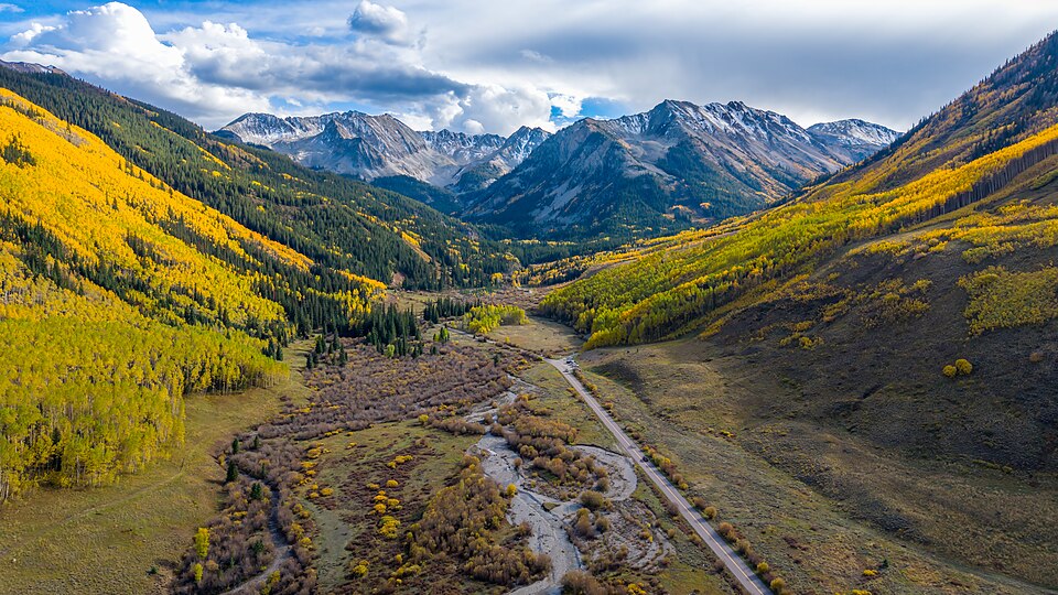
Photograph of Ashcroft
Photograph by RON RAFFETY, CC BY-SA 4.0. Via Wikimedia Commons.

Ashcroft, Colorado

Listed on the National Register of Historic Places in 1975.

From the record

“Ashcroft is an extinct mining town located in Pitkin County, Colorado, United States. The silver mining camp was founded as Castle Forks City in the spring of 1880.”

Wikipedia article Ashcroft, Colorado, CC BY-SA 4.0.

One of 38 National Register listings published here for Pitkin County · listed in 1975 · category: Site.

Sources: the Wikipedia article · the case file at the National Archives · the National Register database, National Park Service · the Wikipedia article

The listing

  • What is counted as historic. The nomination lists 9 buildingss, 1 site as contributing to the listing.
  • Address. 12 mi. S of Aspen in White River National Forest, Aspen, 81612
  • When was it listed? May 1975
  • Category. site
  • Census division. Aspen
  • National Register reference number. 75000533 - the number the National Park Service assigned this property when it was listed, and the key its nomination file is catalogued under at the National Archives.

Fires near this property

7 since 1995

Regional context, not property-specific evidence. The federal wildfire occurrence database lists 7 fires within 5 miles of Ashcroft, Colorado between 1995 and 2014, burning about 2 acres in total. 3 started naturally. None was recorded as arson. Distance is straight-line from the map coordinates, so a fire counted here may appear on a neighbouring settlement's page as well.

Reported cause Fires
Natural3
Recreation and ceremony2
Power generation/transmission/distribution2

The most recent of them, most recent first, with the day each was reported and the service that recorded it.

DateCause SizeReported by Name on the report
7 September 2009Recreation and ceremonyunder an acreWhite River National ForestCONUNDRUM
10 August 1995Recreation and ceremonyunder an acreWhite River National ForestBOUNDARY
19 July 2014Naturalunder an acreWhite River National ForestRICHMOND RIDGE
19 July 2012Naturalunder an acreWhite River National ForestLIMW CREEK
2 June 1999Power generation/transmission/distributionunder an acreWhite River National ForestASHCROFT
23 May 2010Power generation/transmission/distributionunder an acreWhite River National ForestCASTLE CREEK
19 May 2002Naturalunder an acreWhite River National ForestLITTLE ANNIE

Every fire recorded in Pitkin County

Mines and quarries near this property

10 of 33 shown

Regional context, not property-specific evidence. The federal mineral resources record lists 33 workings within 5 miles of Ashcroft, Colorado: 25 past producers, 6 occurrences, 2 producers. 2 still produce. What was taken out: Lead, Iron, Silver, Zinc, Silver. Distance is straight-line from the map coordinates, so a quarry counted here may appear on a neighbouring settlement's page as well.

Where SiteCommodity StatusRecorded
AshcroftGold, Silver, Lead, ZincOccurrence
Columbia DistrictSilver, Lead, Zinc, Iron, Copper, Gold, Molybdenum, Antimony, Titanium, Metal, ManganeseProducer1880, 1881
Difficult Creek DistrictGold, Copper, Silver, ManganeseOccurrence1892
Eclipse MineSilver, LeadPast Producer
Hope MineLead, Silver, Zinc, CopperPast Producer1936
Hope MineLead, Calcium, Gold, ZincPast Producer
Montezuma MineSilver, Zinc, Lead, Copper, GoldPast Producer1881, 1960
Pitkin Iron MineIron, Silver, Titanium, Metal, Manganese, CopperProducer1882, 1960
Porphyry BellCalcium, FeldsparPast Producer
Puzzler LodeIron, MagnesitePast Producer

Every working recorded in Pitkin County

Storms near this property

12 since 1997

Regional context, not property-specific evidence. The National Weather Service names Aspen, the town this property stands in, in 12 storm reports between 1997 and 2023: 4 lightning, 4 flash flood, 2 debris flow, 1 thunderstorm wind. The reports record 1 death and 3 injuries. Each account below is quoted exactly as the forecast office filed it, from the NOAA Storm Events Database, and each date opens the federal record of that event.

WhenEvent Place namedHarm What the report says
July 1997LightningAspen1 killedno account filed
July 2008LightningAspen2 hurtA family of five from Idaho were all struck by lightning while hiking on the American Lake Trail, about 9.5 miles south of Aspen. A 15-year-old girl was revived after being administered CPR. A 17-year-old boy was burned on the soles of his feet. The other three family members did not receive any significant injuries.
July 2000LightningAspen1 hurtno account filed
July 2023Debris FlowAspen$5,000Debris of mud and rock fell across portions of the Rio Grande Trail outside of Aspen as a result of heavy rain from thunderstorms.
August 2021Debris FlowAspen$5,000Pitkin County Sheriff reported the closure of Independence Pass along Colorado Highway 82 between mile markers 47 and 72 due to mudslides.
July 2007Flash FloodAspen$5,000Heavy rain caused water and debris to flow down a normally dry drainage running through the Maroon Creek Day Use Area provided by the USFS. The water and debris average depth was 5 feet with a width of 30 feet. The flash flood hit the Maroon Creek Road and a trailhead parking lot where it spread out about 100 feet wide, clogging culverts and burying the road and day-use area under 1 to 2 feet of debris. Improved trails were destroyed and tons of debris had to be removed from the road and day-use area. Additionally, hailstones up to 1/2 inch diameter accompanied the heavy rain. There were people camping nearby in tents when the event occurred.
July 2006LightningAspen$2,000no account filed
July 2007Heavy RainAspen-Minor flooding and rockslides occurred on Highway 82 just east of Aspen.
June 2005Thunderstorm WindAspen-no account filed
August 2001Flash FloodAspen-no account filed
July 1998Flash FloodAspen-no account filed

Every storm recorded in Pitkin County

Map coverage status

No historic map-sheet match is published for this property yet. That does not mean no map exists. This record needs a coordinate-quality review before it can be joined to a sheet boundary. Browse the county's mapped places while that work is pending.

Sources for this property

National Archives recordThe nomination case file for reference 75000533 in Record Group 79.
Wikipedia articleCommunity-written account of this property, licensed CC BY-SA.
Pitkin CountyAll 38 listed properties in this county.

Provenance

  • Listing record. National Park Service National Register of Historic Places, listed-properties dataset, current to 2026-05-22.
  • Map join. Address geocoded through the United States Census geocoder, then tested against the published boundary of every sheet in the USGS Historical Topographic Map Collection.
  • How this page is made. Listing fields come from federal records; map-sheet coverage is a labelled coordinate-to-boundary calculation, not a source-field claim.
  • Wildfire. Short, Karen C. 2022. Spatial wildfire occurrence data for the United States, 1992-2020 [FPA_FOD_20221014]. 6th Edition. Fort Collins, CO: Forest Service Research Data Archive. https://doi.org/10.2737/RDS-2013-0009.6 Collected with United States Government funding and usable without additional permissions or fees.
  • Mines and quarries. USGS Mineral Resources Data System (MRDS) https://mrdata.usgs.gov/mrds/ A work of the United States government, no copyright under 17 U.S.C. 105.
  • Storms. NOAA National Centers for Environmental Information, Storm Events Database https://www.ncei.noaa.gov/stormevents/ A work of the United States government, no copyright under 17 U.S.C. 105. Narratives are quoted verbatim from the National Weather Service report and are not edited or summarised.