 Block
From the record
One of 7 National Register listings published here for Kit Carson County · category: Building.
Sources: the case file at the National Archives · the National Register database, National Park Service
Listed on the National Register of Historic Places.
One of 7 National Register listings published here for Kit Carson County · category: Building.
Sources: the case file at the National Archives · the National Register database, National Park Service
Regional context, not property-specific evidence. The federal wildfire occurrence database lists 27 fires within 5 miles of Winegar Building between 2011 and 2016, burning about 87 acres in total. 1 started naturally. None was recorded as arson. Distance is straight-line from the map coordinates, so a fire counted here may appear on a neighbouring settlement's page as well.
| Reported cause | Fires |
|---|---|
| Missing data/not specified/undetermined | 23 |
| Equipment and vehicle use | 2 |
| Natural | 1 |
| Fireworks | 1 |
The most recent of them, most recent first, with the day each was reported and the service that recorded it.
| Date | Cause | Size | Reported by | Name on the report |
|---|---|---|---|---|
| 1 September 2011 | Missing data/not specified/undetermined | under an acre | Colorado State Forest Service-State Headquarters | BURLINGTON |
| 8 August 2014 | Missing data/not specified/undetermined | under an acre | Burlington Fire Protection District | UNKNOWN |
| 26 August 2011 | Missing data/not specified/undetermined | under an acre | Colorado State Forest Service-State Headquarters | BURLINGTON |
| 21 August 2013 | Missing data/not specified/undetermined | under an acre | Burlington Fire Protection District | UNKNOWN |
| 19 August 2014 | Equipment and vehicle use | under an acre | Burlington Fire Protection District | UNKNOWN |
| 6 July 2016 | Missing data/not specified/undetermined | 30 acres | Burlington Fire Protection District | UNKNOWN |
| 5 July 2016 | Missing data/not specified/undetermined | under an acre | Burlington Fire Protection District | UNKNOWN |
| 5 July 2016 | Natural | under an acre | Burlington Fire Protection District | UNKNOWN |
Regional context, not property-specific evidence. The federal mineral resources record lists 8 workings within 5 miles of Winegar Building: 4 unknowns, 3 producers, 1 occurrence. 3 still produce. What was taken out: Sand and Gravel, Construction. Distance is straight-line from the map coordinates, so a quarry counted here may appear on a neighbouring settlement's page as well.
| Where | Site | Commodity | Status | Recorded |
|---|---|---|---|---|
| Burlington Pit & Plant | Sand and Gravel, Construction | Producer | ||
| Erker Pit | Sand and Gravel, Construction | Producer | ||
| Johnson Pit | Sand and Gravel, Construction | Producer | ||
| Martens Pit | Sand and Gravel, Construction | Unknown | ||
| Unk | Sand and Gravel, Construction | Unknown | ||
| Unk | Sand and Gravel, Construction | Unknown | ||
| Unk | Sand and Gravel, Construction | Unknown | ||
| Unknown | Sand and Gravel, Construction | Occurrence | Gravel |
Regional context, not property-specific evidence. The National Weather Service names Burlington, the town this property stands in, in 337 storm reports between 1993 and 2026: 184 hail, 124 thunderstorm wind, 13 flash flood, 9 tornado. No death or injury is recorded in these reports. Each account below is quoted exactly as the forecast office filed it, from the NOAA Storm Events Database, and each date opens the federal record of that event.
| When | Event | Place named | Harm | What the report says |
|---|---|---|---|---|
| June 2011 | Thunderstorm Wind | Burlington | $500,000 | A severe microburst destroyed two airport hangars and damaged several aircraft inside. The only hangars destroyed were those oriented north-south. Another hangar nearby received only minor damage. Peak winds measured were from the west. |
| June 2008 | Hail | Burlington | $325,000 | A report relayed from CoCoRAHS indicated leaves were shredded. Also, cars were dented and roof shingles were damaged. |
| September 2021 | Thunderstorm Wind | Burlington | $170,000 | Intense straight line winds due to the microburst first occurred at 8:12 PM MDT near the Burlington airport. This began an area of intermittent damage consistent with wind speeds in the 100-115 mph range. The most intense winds occurred over an area 4.2 miles long and 600 yards wide, ending near Interstate 70 and the Kit Carson Correctional facility. The most significant damage occurred near the Burlington airport where a large evergreen tree was snapped at the trunk and near the Kit Carson Correctional Facility where four power poles were snapped and a nearby outbuilding was destroyed. Damage due to winds in the 60-80 mph range continued to the north of Interstate 70. Additional storm damage included: uprooted trees; damage to the wind and visibility sensors of the KITR ASOS, a camper trailer, overhead garage doors (blown in/dented), fences, windows, siding and roofs of outbuildings and a mobile home; and the flipping of shipping containers and semi-truck trailers. The city of Burlington also lost power as a result of the storm damage. |
| July 2009 | Hail | Burlington | $12,500 | Multiple vehicles received severe hail damage as wind-driven hail moved across Hwy 385 south of Burlington. One person received minor injuries. Hail was reported to have covered the ground. |
| August 2008 | Flash Flood | Burlington | $10,000 | The Kit Carson county fairgrounds was completely flooded by overnight heavy rainfall. |
| August 2008 | Thunderstorm Wind | Burlington | $9,000 | Strong outflow winds broke six power poles, tore away the porch supports from a house and removed the soffit. Three quarters of an inch of rain fell in 15 minutes. |
| June 2011 | Thunderstorm Wind | Burlington | $5,000 | Numerous tree limbs and privacy fences in town were downed or damaged. |
| September 2007 | Thunderstorm Wind | Burlington | $5,000 | Metal building was knocked over and the contents inside the building were damaged. |
| May 2021 | Flash Flood | Burlington | $3,000 | A culvert was washed out from the heavy rainfall. |
| April 2022 | Thunderstorm Wind | Burlington | $1,000 | Large live tree blown down as a line of storms moved through Burlington. |
| July 2021 | Flash Flood | Burlington | $1,000 | Report received of minor street flooding in and around Burlington, CO. Another report of 1.4 inches of storm total rain was received via social media with photo of a rain gauge at one location. This heavy rain produced enough rain for water to reach the running boards on a jeep (estimated 4-6 inches deep). |
| May 2011 | Thunderstorm Wind | Burlington | $1,000 | Sheriff dispatch reported a power pole down in the town of Burlington. |
| May 1998 | Thunderstorm Wind | Burlington | $1,000 | Estimated 60 to 70 mph winds blew out windows. |
| August 2007 | Hail | Burlington | $500 | Cracked windshield of car. |
| July 2014 | Thunderstorm Wind | Burlington | $250 | Three trees were uprooted and one blown approximately 1/8 mile. A small shed was also moved off its base. |
| April 2026 | Thunderstorm Wind | Burlington | - | Measured at Kit Carson County Airport. |
| April 2026 | Thunderstorm Wind | Burlington | - | Measured at Kit Carson County Airport. |
| March 2025 | Thunderstorm Wind | Burlington | - | Burlington ASOS reported winds ranging from 58 to 73 MPH as a line of convective showers moved overhead. |
| March 2025 | Thunderstorm Wind | Burlington | - | As convection moved overhead, the Burlington ASOS reported gusts up to 72 MPH. |
| May 2025 | Thunderstorm Wind | Burlington | - | Blowing dust reducing visibility to less than a half mile was reported with the severe winds. |
| May 2025 | Thunderstorm Wind | Burlington | - | A wall of dust came through town, with visibility falling to a half mile in the dust. |
| May 2025 | Hail | Burlington | - | Numerous reports along with a video of dime to half dollar size hail occurring in the town of Burlington. |
| May 2025 | Hail | Burlington | - | Nickel sized hail was reported in Burlington. |
| May 2025 | Thunderstorm Wind | Burlington | - | The ASOS station KITR Burlington Co Airport reported the wind gust. |
| July 2025 | Thunderstorm Wind | Burlington | - | The ASOS at the Burlington Airport (KITR) measured the 67 mph wind gust. |
| July 2025 | Thunderstorm Wind | Burlington | - | The ASOS at Burlington Airport (KITR) reported the wind gust. The wind gust occurred just behind outflow and ahead of any rainfall. |
| July 2025 | Thunderstorm Wind | Burlington | - | Site KITR reported 63 mph wind gust. |
| August 2025 | Thunderstorm Wind | Burlington | - | The ASOS station KITR at the Burlington Colorado Airport reported the wind gust. |
| September 2025 | Hail | Burlington | - | Estimated quarter to golf ball sized hail that was accumulating. Time estimated based on radar. |
| September 2025 | Tornado (EFU) | Burlington | - | Landspout seen slowly moving north to the west of a farmstead at the CR 47 and L intersection. No damage was reported. |
| July 2024 | Thunderstorm Wind | Burlington | - | The ASOS at the Burlington airport reported an average 5 minute gust of 58 MPH with a peak gust of 64 MPH. |
| June 2024 | Thunderstorm Wind | Burlington | - | Weatherlink station at Andrews Farms. |
| June 2024 | Thunderstorm Wind | Burlington | - | The ASOS at the Burlington airport recorded a 60 MPH gust. |
| June 2024 | Flood | Burlington | - | County sheriff Facebook page shows water flowing across Highway 385 south of the airport. |
| June 2024 | Thunderstorm Wind | Burlington | - | The ASOS in Burlington started measuring severe wind gusts at 43 minutes after the hour with a 60 MPH gust. Over the next 5 minutes, the speeds increased to 96 MPH before the ASOS stopped reporting wind speed because the sensor was damaged. |
| June 2024 | Thunderstorm Wind | Burlington | - | Weatherlink station on road U. |
| June 2024 | Thunderstorm Wind | Burlington | - | NWS Storm Survey crew recorded an area of 60-112 mph straight line winds. Peak wind in the area was 112 mph with damage to grain bins south of the Burlington Airport. Strongest measured gust was 97 mph at the Burlington ASOS. Other notable damage includes numerous trees with broken branches or trunks snapped, and an overturned pivot. The surveyed swath is triangular shaped with a 4 mile long north/south damaged area along Highway 385 centered around the Burlington airport. The swath continues 10 miles southeast from the airport, ending about 0.5 mile south of the junction of county roads J and 55. |
| June 2024 | Thunderstorm Wind | Burlington | - | Irrigation pivot was blown over by estimated 80 mph winds. |
| June 2024 | Thunderstorm Wind | Burlington | - | Reported via ASOS station KITR at the Burlington Co Airport. |
| June 2024 | Thunderstorm Wind | Burlington | - | Two inch diameter tree branch fell on a house in Burlington with estimated 70 mph wind gusts. |
| September 2024 | Thunderstorm Wind | Burlington | - | Two separate wind gusts of 66 mph occurred at the Burlington Airport ASOS with this storms. The first was at 16:45 and the second was at 16:53. |
| August 2024 | Thunderstorm Wind | Burlington | - | Report of a 1.5 inch diameter locust tree branch down. |
| August 2024 | Thunderstorm Wind | Burlington | - | The ASOS at Burlington's airport recorded gusts over 70 MPH for about 10 minutes with a peak gust of 75 MPH. |
| August 2024 | Thunderstorm Wind | Burlington | - | City of Burlington Facebook page reported an hour after the storm had passed, the entire city of Burlington is without power and that it is a Tri-State issue. |
| May 2023 | Thunderstorm Wind | Burlington | - | The KITR ASOS reported a 62 mph thunderstorm wind gust. |
| June 2023 | Hail | Burlington | - | Public report of 0.75 inch hail with visibility reduced to less than 0.25 mile in heavy rain. The storm did not last long. |
| August 2023 | Hail | Burlington | - | Pea to penny sized hail observed over a duration of 5 minutes. |
| July 2023 | Hail | Burlington | - | Public report of Nickel sized hail. |
| July 2023 | Flash Flood | Burlington | - | Kit Carson county dispatch passed along a report of flooding in the basement of a residential home in Burlington, CO. |
| August 2023 | Thunderstorm Wind | Burlington | - | Over a span of eight minutes, the Kit Carson Airport ASOS station reported several gusts ranging from 46 mph to 69 mph. The peak gust of 69 mph occurred at 9:12 pm and 9:18 pm MDT. |
| October 2023 | Thunderstorm Wind | Burlington | - | Reported via ASOS station KITR at the Burlington Airport. |
| June 2022 | Thunderstorm Wind | Burlington | - | Reported gust from the Burlington, CO Airport station. |
| June 2022 | Hail | Burlington | - | Multiple reports of quarter to ping pong ball sized hail over a duration of 10 minutes in the city of Burlington. |
| June 2022 | Thunderstorm Wind | Burlington | - | The ASOS station at the Kit Carson County Airport (KITR) observed sustained winds of 52 to 69 mph with gusts peaking at 85 mph over a period of two minutes before the winds caused an instrument failure. |
| May 2021 | Hail | Burlington | - | The hail ranged from pea to nickel in size. |
| June 2021 | Thunderstorm Wind | Burlington | - | Report received via social media of wind gusts estimated up to 80 mph. Time is estimated by radar and reporting individual. |
| June 2021 | Hail | Burlington | - | Report received via social media hail up to quarter size at location. Time is estimated by radar and reporting individual. |
| July 2021 | Thunderstorm Wind | Burlington | - | The KITR ASOS at the Kit Carson County Airport recorded a 71 mph wind gusts as the storm passed over the site. |
| August 2021 | Thunderstorm Wind | Burlington | - | ASOS reported a 76 mph thunderstorm wind gust at location. |
| August 2021 | Thunderstorm Wind | Burlington | - | ASOS reported a 61 mph thunderstorm wind gust at location. |
No historic map-sheet match is published for this property yet. That does not mean no map exists. This record needs a coordinate-quality review before it can be joined to a sheet boundary. Browse the county's mapped places while that work is pending.
Other National Register properties close enough to walk or drive between, ordered by distance from this one. Both positions come from the same geocoding pass that matched these properties to their map sheets.
| Photograph | Property | Distance | Listed |
|---|---|---|---|
 | Sim Hudson Motor Company | under 500 feet | 2007 |
 | Burlington State Armory | 0.3 miles | 1984 |
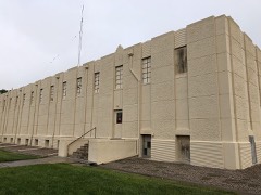 | Burlington Gymnasium | 0.3 miles | 2007 |
 | Elitch Gardens Carousel | 0.3 miles | 1978 |
| National Archives record | The nomination case file for reference 86001123 in Record Group 79. |
| Kit Carson County | All 7 listed properties in this county. |