BlockBefore
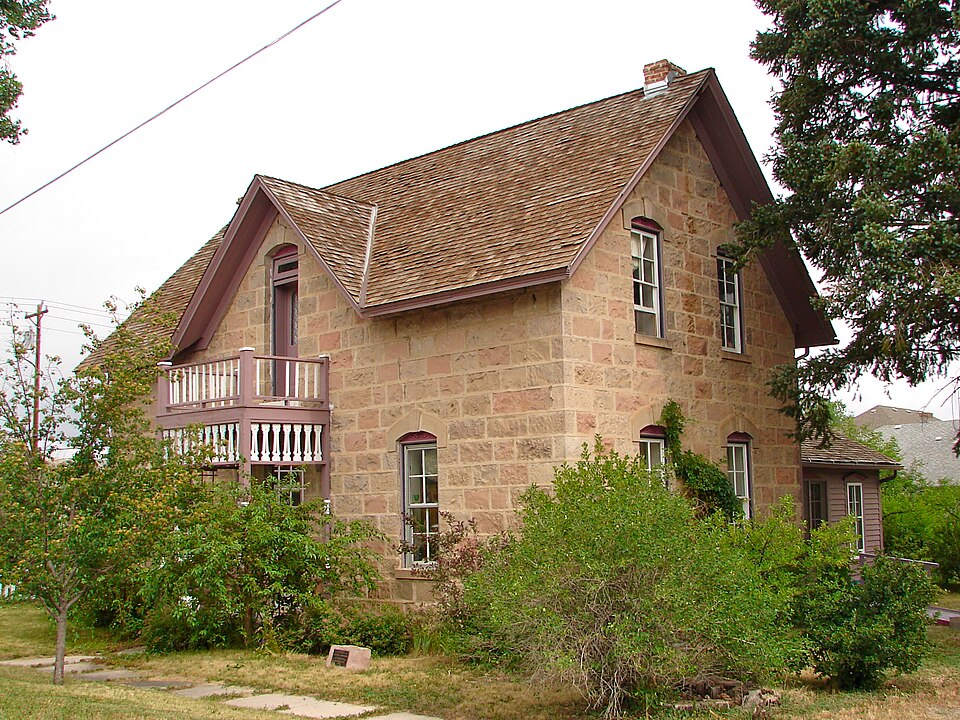
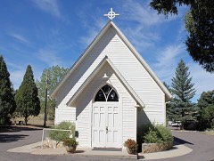
Photograph of Benjamin Hammar House
Photograph by Smallbones, Public domain. Via Wikimedia Commons.

Benjamin Hammar House

Listed on the National Register of Historic Places in 1993.

From the record

“The Benjamin Hammar House is a historic one-and-a-half-story stone and frame residence in Castle Rock, Colorado, United States. The stonemason Benjamin Hammar constructed the house in 1881 in the Craig and Gould neighborhood.”

Wikipedia article Benjamin Hammar House, CC BY-SA 4.0.

One of 24 National Register listings published here for Douglas County · listed in 1993 · category: Building.

Sources: the Wikipedia article · the case file at the National Archives · the National Register database, National Park Service

The listing

  • What is counted as historic. The nomination lists 1 building as contributing to the listing.
  • Listed as. Hammar, Benjamin, House - the National Register files a house under its owner's surname.
  • Address. 203 Cantril St., Castle Rock, 80104
  • When was it listed? February 1993
  • Category. building
  • Census division. Castle Rock
  • National Register reference number. 92001847 - the number the National Park Service assigned this property when it was listed, and the key its nomination file is catalogued under at the National Archives.

Fires near this property

441 since 1992

Regional context, not property-specific evidence. The federal wildfire occurrence database lists 441 fires within 5 miles of Benjamin Hammar House between 1992 and 2020, burning about 1,230 acres in total. 20 started naturally. 16 were recorded as arson. Distance is straight-line from the map coordinates, so a fire counted here may appear on a neighbouring settlement's page as well.

Reported cause Fires
Missing data/not specified/undetermined341
Equipment and vehicle use24
Natural20
Arson/incendiarism16
Smoking16
Misuse of fire by a minor10
Recreation and ceremony5
Debris and open burning5
Fireworks4

The most recent of them, most recent first, with the day each was reported and the service that recorded it.

DateCause SizeReported by Name on the report
9 September 2016Missing data/not specified/undeterminedunder an acreCastle Rock Fire & Rescue DepartmentUNKNOWN
9 September 2010Missing data/not specified/undeterminedunder an acreColorado State Forest Service-State Headquartersnot named
8 September 2019Missing data/not specified/undeterminedunder an acreColorado State Forest Service-State Headquartersnot named
7 September 2015Equipment and vehicle use2.0 acresCastle Rock Fire & Rescue DepartmentUNKNOWN
7 September 2014Missing data/not specified/undeterminedunder an acreCastle Rock Fire & Rescue DepartmentUNKNOWN
6 September 2020Missing data/not specified/undeterminedunder an acreCastle Rock Fire & Rescue DepartmentN/A
6 September 2015Missing data/not specified/undeterminedunder an acreCastle Rock Fire & Rescue DepartmentUNKNOWN
5 September 2019Equipment and vehicle use1.0 acresColorado State Forest Service-State Headquartersnot named

Every fire recorded in Douglas County

Mines and quarries near this property

10 of 32 shown

Regional context, not property-specific evidence. The federal mineral resources record lists 32 workings within 5 miles of Benjamin Hammar House: 24 producers, 4 occurrences, 3 past producers, 1 unknown. 24 still produce. What was taken out: Stone, Sand and Gravel, Construction, Clay, Stone, Crushed/Broken. Distance is straight-line from the map coordinates, so a quarry counted here may appear on a neighbouring settlement's page as well.

Where SiteCommodity StatusRecorded
Johnson, Scott, & BrickyardFire Clay (Refractory)Occurrence
M Y MGypsum-AnhydritePast Producer
UnknownStone, DimensionProducerTuff
Unnamed Gold OccurrenceGold, SilverOccurrencePlacer
ClaypitClayProducer
ClaypitClayProducer
ClaypitClayProducer
Gravel PitStone, Crushed/BrokenProducer

Every working recorded in Douglas County

Storms near this property

60 of 96 shown

Regional context, not property-specific evidence. The National Weather Service names Castle Rock, the town this property stands in, in 96 storm reports between 1993 and 2025: 67 hail, 12 lightning, 8 thunderstorm wind, 4 tornado. The reports record 6 injuries. Each account below is quoted exactly as the forecast office filed it, from the NOAA Storm Events Database, and each date opens the federal record of that event.

WhenEvent Place namedHarm What the report says
August 2004LightningCastle Rock2 hurtTwo men were shocked when lightning hit the ground nearby, as they were golfing the eighth green at Castle Pines. The two golfers suffered only minor injuries.
July 2006LightningCastle Rock1 hurtLightning struck a teenager as he was mowing his lawn and listening to an iPod. The teen suffered burns to his hands and feet, and had blood running from his ear when he was found. The victim's eardrums were ruptured and his hearing was damaged.
June 2004LightningCastle Rock1 hurtLightning struck a power pole in Castle Rock igniting a small fire and injuring a 12-yr old girl standing nearby. The girl received minor injuries from the electrical shock. Lightning also sparked a small brush fire. The fire was quickly extinguished without incident.
May 2001LightningCastle Rock1 hurtA construction worker received minor injuries when he took an indirect lightning strike.
June 1997LightningCastle Rock1 hurtLightning struck a security guard at the Castle Pines Golf Course. He received minor injuries.
July 2006LightningCastle Rock$125,000Lightning struck a residence causing extensive damage to the roof as well as the side of the home.
July 2000LightningCastle Rock$100,000Lightning struck a home is Castle Rock causing extensive damage. The majority of the damage was confined to the roof, attic and second floor.
August 2013Flash FloodCastle Rock$50,000Flash flooding occurred along Interstate 25, south of Castle Rock.
August 1997LightningCastle Rock$20,000Lightning struck a home sparking a fire.
August 2005LightningCastle Rock$15,000Lightning struck an unoccupied home in Parker. The fire caused damage to the roof, attic and second floor bedroom.
July 2014LightningCastle Rock$10,000Lightning struck a home and sparked a small fire in the attic.
August 2008LightningCastle Rock$10,000no account filed
June 2009Heavy RainCastle Rock$5,000Heavy rain caused significant trail damage in Castlewood Canyon. A couple of wooden walkways over the creek were also washed out.
September 1993Thunderstorm WindCastle Rock$500Thunderstorm winds blew over power lines which caused a power outage in Castle Rock.
October 2025HailCastle Rock-The report was received from MPING.
June 2020Thunderstorm WindCastle Rock-Intense winds snapped tree limbs up to 3 inches in diameter.
September 2013Flash FloodCastle Rock-Flash flooding forced the closure of Wolfsenburger Road, west of Castle Rock. In addition, Cherry Creek near Parker was 1.5 feet above flood stage.
July 2009Tornado (EF0)Castle Rock-A tornado touched down but did no damage.
August 2008Tornado (EF0)Castle Rock-A landspout tornado touched down but did no damage.
June 2006Thunderstorm WindCastle Rock-Severe thunderstorm winds snapped power lines a distance of one quarter of a mile.
June 2004Tornado (F0)Castle Rock-A tornado touched down briefly, blowing the roof off a machine shop.
June 2004Tornado (F0)Castle Rock-A small tornado trouhed down briefly but did no damage.
July 1998Flash FloodCastle Rock-Heavy rain, up to 3 inches in an hour, caused flash flooding problems from Castle Rock to Parker. Interstate 25, north of Castle Rock, was closed as highwaters covered sections of the highway. Some cars were left floating in the floodwaters.
June 2021HailCastle Rock-no account filed
August 2021HailCastle Rock-no account filed
June 2020HailCastle Rock-no account filed
July 2020HailCastle Rock-no account filed
June 2020Thunderstorm WindCastle Rock-no account filed
June 2019HailCastle Rock-no account filed
August 2017HailCastle Rock-no account filed
June 2016HailCastle Rock-no account filed
July 2016HailCastle Rock-no account filed
May 2016HailCastle Rock-no account filed
April 2016HailCastle Rock-no account filed
June 2014HailCastle Rock-no account filed
June 2013HailCastle Rock-no account filed
August 2013HailCastle Rock-no account filed
July 2011HailCastle Rock-no account filed
June 2010HailCastle Rock-no account filed
August 2009HailCastle Rock-no account filed
August 2008HailCastle Rock-no account filed
May 2007HailCastle Rock-no account filed

Every storm recorded in Douglas County

Map coverage status

No historic map-sheet match is published for this property yet. That does not mean no map exists. This record needs a coordinate-quality review before it can be joined to a sheet boundary. Browse the county's mapped places while that work is pending.

Listed places nearby

6 within 8 miles

Other National Register properties close enough to walk or drive between, ordered by distance from this one. Both positions come from the same geocoding pass that matched these properties to their map sheets.

Photograph PropertyDistance Listed
Samuel Dyer Houseunder 500 feet2016
Castle Rock Elementry Schoolunder 500 feet1984
First National Bank of Douglas County0.2 miles1995
Keystone Hotel0.2 miles1997
Castle Rock Depot0.4 miles1974
Church of St. Philip-in-the-Field and Bear Canon Cemetery5.5 miles1973

Sources for this property

National Archives recordThe nomination case file for reference 92001847 in Record Group 79.
Wikipedia articleCommunity-written account of this property, licensed CC BY-SA.
Douglas CountyAll 24 listed properties in this county.

Provenance

  • Listing record. National Park Service National Register of Historic Places, listed-properties dataset, current to 2026-05-22.
  • Map join. Address geocoded through the United States Census geocoder, then tested against the published boundary of every sheet in the USGS Historical Topographic Map Collection.
  • How this page is made. Listing fields come from federal records; map-sheet coverage is a labelled coordinate-to-boundary calculation, not a source-field claim.
  • Wildfire. Short, Karen C. 2022. Spatial wildfire occurrence data for the United States, 1992-2020 [FPA_FOD_20221014]. 6th Edition. Fort Collins, CO: Forest Service Research Data Archive. https://doi.org/10.2737/RDS-2013-0009.6 Collected with United States Government funding and usable without additional permissions or fees.
  • Mines and quarries. USGS Mineral Resources Data System (MRDS) https://mrdata.usgs.gov/mrds/ A work of the United States government, no copyright under 17 U.S.C. 105.
  • Storms. NOAA National Centers for Environmental Information, Storm Events Database https://www.ncei.noaa.gov/stormevents/ A work of the United States government, no copyright under 17 U.S.C. 105. Narratives are quoted verbatim from the National Weather Service report and are not edited or summarised.