
BlockBefore
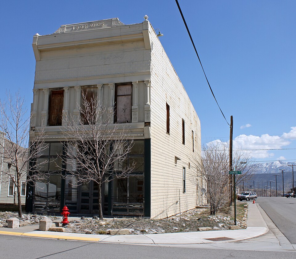
Photograph of IOOF Hall
Photograph by Jeffrey Beall, CC BY 3.0. Via Wikimedia Commons.

IOOF Hall

Listed on the National Register of Historic Places in 1993.

From the record

“The IOOF Hall, which has also been known as Crest Theatre, is a two-story building in De Beque, Colorado that was built in 1900. Its second floor's large lodge room served historically as a meeting hall for the Odd Fellows and corresponding Rebekahs groups.”

Wikipedia article IOOF Hall (De Beque, Colorado), CC BY-SA 4.0.

One of 33 National Register listings published here for Mesa County · listed in 1993 · category: Building.

Sources: the Wikipedia article · the case file at the National Archives · the National Register database, National Park Service · the Wikipedia article
The listing

  • What is counted as historic. The nomination lists 1 building as contributing to the listing.
  • Address. Jct. of 4th St. and Curtis Ave., De Beque, 81630
  • When was it listed? March 1993
  • Category. building
  • Census division. De Beque
  • National Register reference number. 93000200 - the number the National Park Service assigned this property when it was listed, and the key its nomination file is catalogued under at the National Archives.

Fires near this property

194 since 1992

Regional context, not property-specific evidence. The federal wildfire occurrence database lists 194 fires within 5 miles of IOOF Hall between 1992 and 2020, burning about 1,009 acres in total. 116 started naturally. 1 was recorded as arson. Distance is straight-line from the map coordinates, so a fire counted here may appear on a neighbouring settlement's page as well.

Reported cause Fires
Natural116
Missing data/not specified/undetermined55
Smoking8
Equipment and vehicle use7
Railroad operations and maintenance3
Debris and open burning2
Recreation and ceremony1
Arson/incendiarism1
Other causes1

The most recent of them, most recent first, with the day each was reported and the service that recorded it.

DateCause SizeReported by Name on the report
9 September 2011Missing data/not specified/undeterminedunder an acreColorado State Forest Service-State HeadquartersDEBEQUE
9 September 2003Missing data/not specified/undeterminedunder an acreColorado State Forest Service-State Headquartersnot named
7 September 1993Naturalunder an acreNorthwest District, Grand JunctionSMITH GLCH
6 September 2007Naturalunder an acreNorthwest District, Grand JunctionLOGAN
5 September 2020Missing data/not specified/undetermined3.1 acresDeBeque Volunteer Fire DepartmentN/A
4 September 2020Other causes3.1 acresMesa CountyDEBEQUE
27 September 2005Missing data/not specified/undeterminedunder an acreColorado State Forest Service-State Headquartersnot named
24 September 1996Railroad operations and maintenanceunder an acreNorthwest District, Grand JunctionHIGHWAY 6

Every fire recorded in Mesa County

Mines and quarries near this property

1 within 5 miles

Regional context, not property-specific evidence. The federal mineral resources record lists 1 working within 5 miles of IOOF Hall: 1 producer. All of them still produce. What was taken out: Sand and Gravel, Construction. Distance is straight-line from the map coordinates, so a quarry counted here may appear on a neighbouring settlement's page as well.

Where SiteCommodity StatusRecorded
Nichols PitSand and Gravel, ConstructionProducer

Every working recorded in Mesa County

Storms near this property

16 since 1997

Regional context, not property-specific evidence. The National Weather Service names De Beque, the town this property stands in, in 16 storm reports between 1997 and 2023: 5 thunderstorm wind, 3 hail, 3 flood, 2 heavy rain. No death or injury is recorded in these reports. Each account below is quoted exactly as the forecast office filed it, from the NOAA Storm Events Database, and each date opens the federal record of that event.

WhenEvent Place namedHarm What the report says
June 2011FloodDe Beque$125,000Many area waterways in Western Colorado, including the Colorado River, were running at or near bank full conditions to begin June as runoff was enhanced by warming temperatures over a record snow pack. Flood advisories for the Colorado River were in place all of June across Mesa County from near De Beque to the Utah state line. Flood warnings were first issued near Cameo on June 5th, and except for a brief lowering below the flood stagt from the 19th to the 23rd, the warning stayed in place through the end of the month. Minor flooding and bank erosion were experienced from De Beque to the confluence with the Gunnison River in Grand Junction. Some city recreational trails along the river washed away. Within River Bend State Park near Palisade a service road eroded away and part of the disk golf course was washed away. In some areas up to 20 feet of bank was lost to the river and a few homes in Grand Junction and Palisade reported water in the basement from the high water table. ||The Colorado River, from the confluence with the Gunnison River in Grand Junction to the Utah State line was in flood stage from June 7th to June 11th, peaking on the 8th. In numerous places the river flooded low lying areas and approached Interstate 70. The water came within a few inches of closing the I-70 bridge near Skippers Island. A few sections of the river between Fruita and Loma lost between 20 to 30 feet of bank and some utilities were washed out. Multiple agencies and businesses worked to mitigate the flooding problems.
July 2005Thunderstorm WindDe Beque$100,000no account filed
September 2005Thunderstorm WindDe Beque$15,000no account filed
August 2023FloodDe Beque-Heavy rain from thunderstorms resulted in minor flooding/ponding of water on portions of I-70 near mile marker 56 going east towards De Beque.
May 2020HailDe Beque-A severe thunderstorm produced large hail estimated to be the size of quarters south-southeast of De Beque. Dispatch reported numerous vehicles had to shelter under the highway overpass due to the large hail on Interstate 70 south of De Beque with resulting slowdowns on the highway.
May 2020HailDe Beque-A severe thunderstorm produced large hail measured to be the size of half dollars south-southeast of De Beque.
June 2020Thunderstorm WindDe Beque-A peak wind gust of 99 mph was measured by the Great Divide automated weather station.
July 2016Heavy RainDe Beque-Showers and thunderstorms produced torrential rainfall near De Beque, with 1.06 inches measured at one location within three hours. The heavy rain quickly filled up nearby ditches with water.
September 2013Flash FloodDe Beque-Mudslides and flooding closed westbound I-70 from near DeBeque to mile marker 70 for several hours.
June 2012Thunderstorm WindDe Beque-Thunderstorms moving near the Interstate 70 corridor above DeBeque Canyon produced severe wind gusts.
July 2011FloodDe Beque-Flood warnings were in effect for the main stem Colorado River from near DeBeque to Grand Junction on the 1st of July when the river peaked at 13.41 feet. The river then began a slow descent through the remainder of the month, though it fluctuated to advisory levels through July 11th. Minor flooding and bank erosion along the river from DeBeque to the Colorado-Utah state line continued through the first part of the month due to the fast flows and near bankfull conditions.
July 2007Heavy RainDe Beque-Heavy rain producing thunderstorms resulted in 2 to 3 inches of water to flow over County Road 45.5 at Shire Gulch.
June 2005Thunderstorm WindDe Beque-no account filed
August 2005HailDe Beque-no account filed
June 1999WildfireDe Beque-no account filed
September 1997Funnel CloudDe Beque-no account filed

Every storm recorded in Mesa County

Map coverage status

No historic map-sheet match is published for this property yet. That does not mean no map exists. This record needs a coordinate-quality review before it can be joined to a sheet boundary. Browse the county's mapped places while that work is pending.

Listed places nearby

2 within 8 miles

Other National Register properties close enough to walk or drive between, ordered by distance from this one. Both positions come from the same geocoding pass that matched these properties to their map sheets.

Photograph PropertyDistance Listed
De Beque House0.3 miles1995
Colorado River Bridge1.2 miles2002

Sources for this property

National Archives recordThe nomination case file for reference 93000200 in Record Group 79.
Wikipedia articleCommunity-written account of this property, licensed CC BY-SA.
Mesa CountyAll 33 listed properties in this county.

Provenance

  • Listing record. National Park Service National Register of Historic Places, listed-properties dataset, current to 2026-05-22.
  • Map join. Address geocoded through the United States Census geocoder, then tested against the published boundary of every sheet in the USGS Historical Topographic Map Collection.
  • How this page is made. Listing fields come from federal records; map-sheet coverage is a labelled coordinate-to-boundary calculation, not a source-field claim.
  • Wildfire. Short, Karen C. 2022. Spatial wildfire occurrence data for the United States, 1992-2020 [FPA_FOD_20221014]. 6th Edition. Fort Collins, CO: Forest Service Research Data Archive. https://doi.org/10.2737/RDS-2013-0009.6 Collected with United States Government funding and usable without additional permissions or fees.
  • Mines and quarries. USGS Mineral Resources Data System (MRDS) https://mrdata.usgs.gov/mrds/ A work of the United States government, no copyright under 17 U.S.C. 105.
  • Storms. NOAA National Centers for Environmental Information, Storm Events Database https://www.ncei.noaa.gov/stormevents/ A work of the United States government, no copyright under 17 U.S.C. 105. Narratives are quoted verbatim from the National Weather Service report and are not edited or summarised.