 Block
From the record
One of 10 National Register listings published here for Huerfano County · listed in 1993 · category: Building.
Sources: the case file at the National Archives · the National Register database, National Park Service
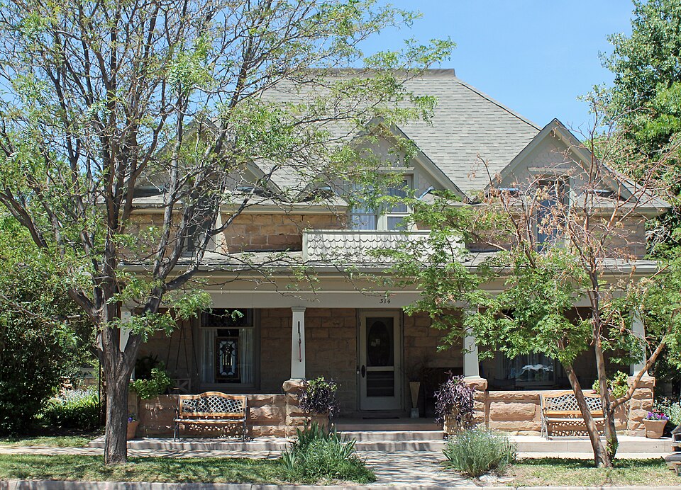
Listed on the National Register of Historic Places in 1993.
One of 10 National Register listings published here for Huerfano County · listed in 1993 · category: Building.
Sources: the case file at the National Archives · the National Register database, National Park Service
Regional context, not property-specific evidence. The federal wildfire occurrence database lists 22 fires within 5 miles of Lamme Hospital between 1995 and 2020, burning about 273 acres in total. 2 started naturally. 2 were recorded as arson. Distance is straight-line from the map coordinates, so a fire counted here may appear on a neighbouring settlement's page as well.
| Reported cause | Fires |
|---|---|
| Missing data/not specified/undetermined | 14 |
| Arson/incendiarism | 2 |
| Natural | 2 |
| Smoking | 2 |
| Misuse of fire by a minor | 1 |
| Debris and open burning | 1 |
The most recent of them, most recent first, with the day each was reported and the service that recorded it.
| Date | Cause | Size | Reported by | Name on the report |
|---|---|---|---|---|
| 5 September 2011 | Missing data/not specified/undetermined | under an acre | Colorado State Forest Service-State Headquarters | LA VETA |
| 11 September 2011 | Missing data/not specified/undetermined | under an acre | Colorado State Forest Service-State Headquarters | LA VETA |
| 12 July 2014 | Natural | under an acre | La Veta Fire Protection District | UNKNOWN |
| 11 July 2011 | Missing data/not specified/undetermined | under an acre | Colorado State Forest Service-State Headquarters | LA VETA |
| 3 June 2018 | Natural | under an acre | La Veta Fire Protection District | UNKNOWN |
| 11 June 2011 | Missing data/not specified/undetermined | under an acre | Colorado State Forest Service-State Headquarters | LA VETA |
| 5 May 2013 | Missing data/not specified/undetermined | under an acre | La Veta Fire Protection District | UNKNOWN |
| 4 April 2020 | Smoking | under an acre | La Veta Fire Protection District | N/A |
Regional context, not property-specific evidence. The federal mineral resources record lists 6 workings within 5 miles of Lamme Hospital: 6 past producers. None of them still produces. What was taken out: Sand and Gravel, Construction. Distance is straight-line from the map coordinates, so a quarry counted here may appear on a neighbouring settlement's page as well.
| Where | Site | Commodity | Status | Recorded |
|---|---|---|---|---|
| Unknown | Sand and Gravel, Construction | Past Producer | ||
| Unknown | Sand and Gravel, Construction | Past Producer | ||
| Unknown | Sand and Gravel, Construction | Past Producer | ||
| Unknown | Sand and Gravel, Construction | Past Producer | ||
| Unknown | Sand and Gravel, Construction | Past Producer | ||
| Unknown | Sand and Gravel, Construction | Past Producer |
Regional context, not property-specific evidence. The National Weather Service names La Veta, the town this property stands in, in 32 storm reports between 2000 and 2024: 14 flash flood, 9 heavy rain, 6 hail, 1 lightning. No death or injury is recorded in these reports. Each account below is quoted exactly as the forecast office filed it, from the NOAA Storm Events Database, and each date opens the federal record of that event.
| When | Event | Place named | Harm | What the report says |
|---|---|---|---|---|
| June 2000 | Lightning | La Veta | $40,000 | A summer house was totally destroyed by a lightning started fire. |
| July 2014 | Flash Flood | La Veta | $3,000 | no account filed |
| June 2024 | Flash Flood | La Veta | - | Heavy rainfall led to some water over short stretches of Hwy 160, county roads, ditches, and other low-lying areas. No other notable impacts reported. Radar-estimated rainfall of 1.5-2.0 inches occurred over impacted areas within warning area. |
| June 2024 | Thunderstorm Wind | La Veta | - | Public source (via mPing) reported wind damage with 1 inch tree limbs broken and shingles blown off. |
| June 2023 | Hail | La Veta | - | Public reported. |
| June 2023 | Heavy Rain | La Veta | - | There was 1.6 inches of rain reported. |
| July 2022 | Heavy Rain | La Veta | - | Heavy rainfall of 1.53 inches. |
| July 2022 | Heavy Rain | La Veta | - | Heavy rainfall of 1.82 inches measured at Harrison Bridge near Cucharas, in one hour. |
| July 2021 | Flash Flood | La Veta | - | Road 421 was overtopped for hundreds of yards. |
| August 2021 | Heavy Rain | La Veta | - | Heavy rainfall of 3.70 inches. |
| July 2021 | Heavy Rain | La Veta | - | Heavy rainfall of 3.45 inches. |
| May 2021 | Heavy Rain | La Veta | - | Heavy rain of 1.70 inches, La Veta. |
| May 2021 | Heavy Rain | La Veta | - | Heavy rain of 2.54 inches, 5 miles north northeast Spanish Peaks. |
| May 2020 | Heavy Rain | La Veta | - | One-hour total. |
| August 2020 | Heavy Rain | La Veta | - | Heavy rainfall of 1.9 inches. |
| August 2020 | Flash Flood | La Veta | - | Rushing water across CR 421 along Indian creek, about a foot deep. Road is impassable. |
| August 2020 | Debris Flow | La Veta | - | Mud slide across Highway 12 has closed the road down from mm 13-14, per CSP Pueblo. |
| September 2019 | Flash Flood | La Veta | - | County road 430 is submerged by heavy flows from Middle Creek. |
| July 2019 | Flash Flood | La Veta | - | Water has over-topped CR 430. |
| July 2019 | Flash Flood | La Veta | - | Highway 12 in La Veta has been closed with water flowing across the road surface. Water was at least 4 inches deep. |
| July 2019 | Flash Flood | La Veta | - | County Road 440 has been washed out with possible damage to nearby railroad tracks. |
| July 2019 | Flash Flood | La Veta | - | At least 2 feet of water rapidly flowing across CR 430. Looks to impact at least 100 yards of the road surface. |
| July 2019 | Flash Flood | La Veta | - | Middle Creek has over topped its banks with water flowing across CR 430. |
| August 2016 | Flash Flood | La Veta | - | A storm produced heavy rain and flash flooding of drainages and roadways east of East Spanish Peak. |
| July 2013 | Flash Flood | La Veta | - | Several county roads, including Shangri-La subdivision and CR 340, experienced flooding and washouts within the East Peak burn scar north of East Spanish Peak. |
| July 2006 | Flash Flood | La Veta | - | Heavy thunderstorm rains and subsequent flooding caused road damage near La Veta in Huerfano County. |
| May 2021 | Hail | La Veta | - | no account filed |
| August 2018 | Hail | La Veta | - | no account filed |
| August 2018 | Hail | La Veta | - | no account filed |
| July 2014 | Flash Flood | La Veta | - | no account filed |
| June 2007 | Hail | La Veta | - | no account filed |
| June 2007 | Hail | La Veta | - | no account filed |
No historic map-sheet match is published for this property yet. That does not mean no map exists. This record needs a coordinate-quality review before it can be joined to a sheet boundary. Browse the county's mapped places while that work is pending.
Other National Register properties close enough to walk or drive between, ordered by distance from this one. Both positions come from the same geocoding pass that matched these properties to their map sheets.
| Photograph | Property | Distance | Listed |
|---|---|---|---|
 | Francisco Plaza | under 500 feet | 1986 |
| Smith, Edwin L. Building | under 500 feet | 2020 |
| National Archives record | The nomination case file for reference 93001376 in Record Group 79. |
| Huerfano County | All 10 listed properties in this county. |