 Block
From the record
One of 110 National Register listings published here for Larimer County · listed in 1994 · category: District.
Sources: the case file at the National Archives · the National Register database, National Park Service
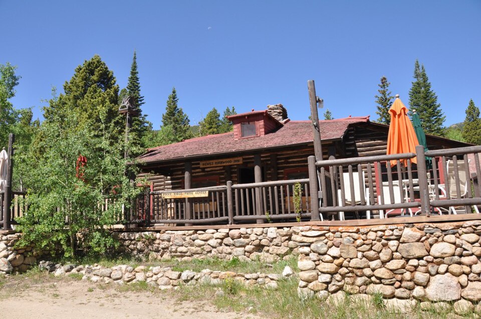
Listed on the National Register of Historic Places in 1994.
One of 110 National Register listings published here for Larimer County · listed in 1994 · category: District.
Sources: the case file at the National Archives · the National Register database, National Park Service
Regional context, not property-specific evidence. The federal wildfire occurrence database lists 143 fires within 5 miles of Hewes-Kirkwood Inn between 1992 and 2020, burning about 18 acres in total. 19 started naturally. None was recorded as arson. Distance is straight-line from the map coordinates, so a fire counted here may appear on a neighbouring settlement's page as well.
| Reported cause | Fires |
|---|---|
| Missing data/not specified/undetermined | 78 |
| Recreation and ceremony | 32 |
| Natural | 19 |
| Equipment and vehicle use | 8 |
| Power generation/transmission/distribution | 3 |
| Debris and open burning | 3 |
The most recent of them, most recent first, with the day each was reported and the service that recorded it.
| Date | Cause | Size | Reported by | Name on the report |
|---|---|---|---|---|
| 6 September 2010 | Missing data/not specified/undetermined | under an acre | Colorado State Forest Service-State Headquarters | not named |
| 26 September 1992 | Recreation and ceremony | under an acre | Arapaho and Roosevelt National Forests and Pawnee National Grassland | not named |
| 24 September 2002 | Equipment and vehicle use | under an acre | Rocky Mountain National Park | LONE PEAK |
| 20 September 1994 | Recreation and ceremony | under an acre | Arapaho and Roosevelt National Forests and Pawnee National Grassland | ALLENSPARK #1 |
| 19 September 2015 | Debris and open burning | under an acre | Allenspark Fire Protection District | UNKNOWN |
| 14 September 2017 | Missing data/not specified/undetermined | under an acre | Allenspark Fire Protection District | UNKNOWN |
| 14 September 2017 | Recreation and ceremony | under an acre | Arapaho and Roosevelt National Forests and Pawnee National Grassland | TWIN TRAIL |
| 11 September 2017 | Missing data/not specified/undetermined | under an acre | Allenspark Fire Protection District | UNKNOWN |
Regional context, not property-specific evidence. The federal mineral resources record lists 3 workings within 5 miles of Hewes-Kirkwood Inn: 2 occurrences, 1 past producer. None of them still produces. What was taken out: Gold, Beryllium. Distance is straight-line from the map coordinates, so a quarry counted here may appear on a neighbouring settlement's page as well.
| Where | Site | Commodity | Status | Recorded |
|---|---|---|---|---|
| Twin Sister | Beryllium | Past Producer | ||
| Unknown | Gold | Occurrence | Gold | |
| Unknown | Gold | Occurrence | Gold |
Regional context, not property-specific evidence. The National Weather Service names Estes Park, the town this property stands in, in 20 storm reports between 1996 and 2023: 11 hail, 6 lightning, 1 flash flood, 1 tornado. The reports record 2 deaths and 13 injuries. Each account below is quoted exactly as the forecast office filed it, from the NOAA Storm Events Database, and each date opens the federal record of that event.
| When | Event | Place named | Harm | What the report says |
|---|---|---|---|---|
| July 1999 | Lightning | Estes Park | 1 killed, 2 hurt | Lightning killed a 35-yr old man and seriously injured his wife and young daughter. The family was hiking near the Gore Range Overlook along Trail Ridge Road when the thunderstorm developed, at an elevation of 11,700 feet. |
| August 1999 | Lightning | Estes Park | 1 killed, 2 hurt | Lightning killed one hiker and injured two others, while they were hiking a remote drainage in Rocky Mountain National Park. |
| August 1998 | Lightning | Estes Park | 6 hurt | Six people received minor injuries when lightning struck a nearby scenic overlook atop Trail Ridge Road. The charge apparently travelled across the ground and shocked the group. |
| October 2000 | Lightning | Estes Park | 2 hurt | Two people were injured when they were struck by lightning at the Forest Canyon Overlook, at nearly 12,000 feet elevation along Trail Ridge Road. The thunderstorm formed rapidly overhead. One of the victims was badly burned, the other had no visible injuries. |
| August 2019 | Lightning | Estes Park | 1 hurt | A hiker was seriously injured by lightning while hiking in Rocky Mountain National Park. |
| July 2011 | Lightning | Estes Park | $5,000 | Lightning sparked three fires. |
| July 2022 | Hail | Estes Park | - | Torrential hail and rain occurred in the town of Estes Park. The hail piled up to a foot deep and snowplows were called in to remove it. |
| June 2021 | Heavy Rain | Estes Park | - | Moderate to heavy rainfall associated with a thunderstorm produced minor flooding along Trail Ridge Road. |
| May 2018 | Tornado (EF0) | Estes Park | - | A weak tornado touched down briefly near Bear Lake with no observable damage. |
| September 2013 | Flash Flood | Estes Park | - | Heavy rain caused five very small dams in the Big Elk Meadows area to fail. As a result, a family became trapped when a county road was washed out and floodwaters damaged their home. Road closures included: U.S. 34 east/west, between Loveland and Estes Park; CO14 east/west, between Walden and Ted's Place. Larimer County Roads 27E, 25E, 52E and 54E were all closed near La Porte due to flash flooding. Several roads were also washed out southwest of Loveland and north of Fort Collins. |
| June 2023 | Hail | Estes Park | - | no account filed |
| June 2016 | Hail | Estes Park | - | no account filed |
| July 2010 | Hail | Estes Park | - | no account filed |
| July 2007 | Hail | Estes Park | - | no account filed |
| June 2006 | Hail | Estes Park | - | no account filed |
| July 2005 | Hail | Estes Park | - | no account filed |
| June 2004 | Hail | Estes Park | - | no account filed |
| June 1999 | Hail | Estes Park | - | no account filed |
| June 1996 | Hail | Estes Park | - | no account filed |
| June 1996 | Hail | Estes Park | - | no account filed |
No historic map-sheet match is published for this property yet. That does not mean no map exists. This record needs a coordinate-quality review before it can be joined to a sheet boundary. Browse the county's mapped places while that work is pending.
Other National Register properties close enough to walk or drive between, ordered by distance from this one. Both positions come from the same geocoding pass that matched these properties to their map sheets.
| Photograph | Property | Distance | Listed |
|---|---|---|---|
| Leiffer House | 0.6 miles | 1978 | |
| Enos Mills Homestead Cabin | 1.0 miles | 1973 | |
 | East Longs Peak Trail-Longs Peak Trail-Keyhole Route-Shelf Trail | 1.9 miles | 2007 |
 | Twin Sisters Lookout | 2.3 miles | 1992 |
 | Baldpate Inn | 2.7 miles | 1996 |
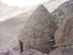 | Agnes Vaille Shelter | 3.5 miles | 1992 |
| National Archives record | The nomination case file for reference 94001254 in Record Group 79. |
| Larimer County | All 110 listed properties in this county. |