Listed on the National Register of Historic Places in 2001.
From the record
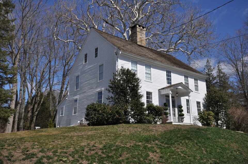
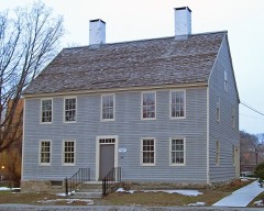
“John Ely House is a historic house at 54 Milwaukee Avenue in Bethel, Connecticut. Built in 1792, it is well-preserved example of period domestic architecture, and is further notable for a procession of owners important in the community's history.”
Wikipedia article Rev. John Ely House, CC BY-SA 4.0.
One of 298 National Register listings published here for Fairfield County · listed in 2001 · category: Building.
National Register reference number.01000400- the number the National Park Service assigned this property when it was listed, and the key its nomination file is catalogued under at the National Archives.
The assemblage of dwellings, stores, factories, and shops constituting the village of Bethel is neither upon a hill nor in a valley, nor yet is it on a plain. Still there are hills and valleys, and upon the sides and summits of the hills, and in the lower grounds, the dwellings, the stores, and the factories are located. The grassy plain upon our western border, and now included in the borough of Bethel, is the only level ground of any considerable extent within the limits of the town. It certainly appears to be the only feasible situation in or upon which to locate a town site, and even this is of comparatively moderate extent. It is only a few years - certainly within the memory of many citizens now living - that this district seemed of small account, but within the last thirty-five years it has made wonderful strides towards metropolitan dignity. It has a number of fine residences, as good as the best in town. In Grassy Plain, also, you may find the best constructed, if not the largest, hat-factory in Bethel. It is a large structure, built of brick, and its business is conducted by the well-known firm of 0. Benedict & Co. In good times, when hats are in lively demand and all hands - numbering one hundred or more - are at work, it can turn out from one hundred and twenty-five dozen to one hundred and fifty dozen hats per day.
As Bethel was a portion of Danbury at the date of the settlement of this part of the country, it follows naturally that a great deal of the early history of the younger place will be found in the records of the older one. Our town records were kept in Danbury, we voted at Danbury at Presidential elections, at State elections, and at town-meetings for many, many years. But as the first settlers came from Norwalk, they were obliged to pass through the territory now belonging to Bethel in order to reach their new homes, on streets now called South and Main Streets in the borough of Danbury. And these first settlers - the pioneers - had no smooth highway through Redding. Their first path was through the woods on the west side of the pond, and between that and tlie mountain. Tlie pond jio\y called "Sympang" (a good old Indian name it is) was, until the last quarter of a century, or perchance thirty-five years at most, known as " Milking- Yard Pond." The high hill on the west was always in the past called " Milking- Yard Mountain," and the broken, hillocky land (perhaps one hundred acres) lying between pond and mountain was and still is known by the name of " Milking- Yard Farm." The name came naturally enough. More than fifty yeai's ago, in the tender years of infancy and childhood, did the writer hear from the old Eevolutionary grandsire about the trouble the early settlers had with their cattle, particularly the cows, for before these pioneers had time to fence their grants, purchases, or farms, said cows would leave their " pastures fresh" in the upcountry and return to the familiar scenes where now stands Norwalk. To prevent the exodus of the beasts a fence was built across the milking-yard farm, socalled, from the south end of the pond to the mountain on the west, the distance not being more than thirty rods. Here the progress of the cows towards their old home by the shore was stayed ; and from on what is now Danbury's Main Street lads and lasses, grave fathers and sedate mothers rode on horseback a distance of three miles to milk the cows, for there Avere no wagons hereabout in those early days. We can hardly imagine the fun there must have been. Each horse, furnished with saddle and pillion for the occasion, would carry from two to four gay passengers. The cows having been milked, were left to their own " sweet will," while man and maiden returned with brimming pails of the healthful fluid. And thus it continued until the settlers could com})lete their houses and fence their fields.
Regional context, not property-specific
evidence. The
federal wildfire occurrence database
lists 13 fires within 5 miles of Rev. John Ely House
between 1994 and 2020, burning about 46 acres in total. None started naturally. 2 were recorded as arson.
Distance is straight-line from the map coordinates, so a fire counted
here may appear on a neighbouring settlement's page as well.
Reported cause
Fires
Missing data/not specified/undetermined
6
Misuse of fire by a minor
2
Debris and open burning
2
Arson/incendiarism
2
Recreation and ceremony
1
The most recent of
them, most recent first, with the day each was reported and the service
that recorded it.
Regional context, not property-specific
evidence. The federal mineral resources record lists
30 workings within 5 miles of Rev. John Ely House: 22 past producers, 5 producers, 1 occurrence, 1 unknown.
5 still produce. What was taken out: Sand and Gravel, Construction, Stone, Stone, Crushed/Broken, Garnet. Distance is straight-line from the
map coordinates, so a quarry counted here may appear on a neighbouring
settlement's page as well.
Regional context, not property-specific
evidence. The National Weather Service names
Bethel, the town this property stands in, in 22 storm reports between 1995 and 2020: 12 thunderstorm wind, 4 hail, 3 flash flood, 2 flood.
No death or injury is recorded in these reports. Each account below is quoted exactly as the forecast office
filed it, from the NOAA Storm Events Database, and each date
opens the federal record of that event.
Super saturated grounds caused a 70 ft. tree to fall on a house on Great Plains Rd in Danbury. Another tree fell on a house on Hudson Dr. in New Fairfield, taking down the utility wires from the road to the home. The sewer system backed up into the Bethel Police Dept. on Plumtrees Rd. and was inundated by a mix of rain water and raw sewage.
Numerous trees and power lines downed as a result of very strong thunderstorm wind gusts. The hardest hit area was along the northern portion of route 202.
No historic map-sheet match is published
for this property yet. That does not mean no map exists. This record needs
a coordinate-quality review before it can be joined to a sheet boundary.
Browse the county's mapped places while that work is
pending.
Listed places nearby
6 within 8 miles
Other National Register properties close
enough to walk or drive between, ordered by distance from this one. Both
positions come from the same geocoding pass that matched these properties
to their map sheets.
Listing record. National Park Service National Register of Historic Places, listed-properties dataset, current to 2026-05-22.
Map join. Address geocoded through the United States Census geocoder, then tested against the published boundary of every sheet in the USGS Historical Topographic Map Collection.
How this page is made. Listing fields come from federal records; map-sheet coverage is a labelled coordinate-to-boundary calculation, not a source-field claim.
Wildfire. Short, Karen C. 2022. Spatial wildfire occurrence data for the United States, 1992-2020 [FPA_FOD_20221014]. 6th Edition. Fort Collins, CO: Forest Service Research Data Archive. https://doi.org/10.2737/RDS-2013-0009.6 Collected with United States Government funding and usable without additional permissions or fees.
Mines and quarries. USGS Mineral Resources Data System (MRDS) https://mrdata.usgs.gov/mrds/ A work of the United States government, no copyright under 17 U.S.C. 105.
Storms. NOAA National Centers for Environmental Information, Storm Events Database https://www.ncei.noaa.gov/stormevents/ A work of the United States government, no copyright under 17 U.S.C. 105. Narratives are quoted verbatim from the National Weather Service report and are not edited or summarised.
 Block