 Block
From the record
One of 197 National Register listings published here for New London County · listed in 2025 · category: Building.
Sources: the National Register database, National Park Service
Listed on the National Register of Historic Places in 2025.
One of 197 National Register listings published here for New London County · listed in 2025 · category: Building.
Sources: the National Register database, National Park Service
The chapter on Groton Town in History of New London County, Connecticut, with Biographical Sketches of Many of Its Pioneers and Prominent Men, published 1882 names Groton. This is what it says, exactly as the scans read.
DuMNG this period a choice selection from these names will be found upon the roll of the Assembly from this town. We will hasten to show the patriotic part Groton also took in the agitation which preceded the battles of Concord, Lexington, and Bunker Hill, and the heroic action of her sons at Bunker Hill and during the entire war for independence, culminating in the battle on Groton Heights. We have already said that the town of Groton was settled by men and women that took an interest in the cause of education, and their successors, at the dawn of the Revolution, took a deep interest in the progress of liberty. They viewed with just indignation every measure of repression adopted by Great Britain tending to curtail independence of thought and action among the colonies. The presence of such men as Ebenezer, John, and William Ledyard, Silas Deane, Thomas Mumford, and the young men of the Avery, Morgan, Gallup, Allyn, Gere, Packer, Burrows, Billings, Fanning, Niles, Williams, Fish, Starr, Latham, Perkins, Stoddard, Hurlbut, Chester, Eldredge, and other families in the frequent town-meetings of Groton accounts for the bold and patriotic spirit which everywhere animates their public meetings. To begin with the year 1774, when the colonies were greatly excited by successive acts of Parliament, and especially by the act of Parliament which shut up the port of Boston, we copy the records, mostly verbatim, to justify the claim we make of enlightened patriotism in our country towns, and of this town in particular. At a town-meeting held in Groton on Monday, the 20th day of June, a.d. 1774, William AVilliams, Esq., moderator, -
Passage source: History of New London County, Connecticut, with Biographical Sketches of Many of Its Pioneers and Prominent Men, published 1882.
The Committee of Inspection for 1775 has Hon. William Williams for chairman, and the new names of Simeon Avery, Stephen Billings, Rev. Park Avery, and Nathan Gallup. The others are as before. In January, 1775, Thomas Mumford, Esq., and Lieut. Nathan Gallup were appointed agents of the town "to represent to the Honorable General Assembly the situation and circumstances of said town of Groton, the need and necessity of a Fortification on Groton Heights near the ferry, and to obtain an order to draw money out of the colonial treasury for whatever cost they have been or may be at for the purposes aforesaid, with officers to take care of the same." As the result of this movement, Fort Griswold was built, mainly by the hands of the patriotic citizens of Groton.
Passage source: History of New London County, Connecticut, with Biographical Sketches of Many of Its Pioneers and Prominent Men, published 1882.
Machine-read from a century-old scan, so expect the errors a machine makes: misspelled names, dropped words, stray characters.
Read the whole chapter on Groton Town - 15,472 words on its settlement, mills, schools and churches.
Regional context, not property-specific evidence. The federal wildfire occurrence database lists 29 fires within 5 miles of Shepherd of the Sea Chapel between 1992 and 2020, burning about 108 acres in total. None started naturally. 3 were recorded as arson. Distance is straight-line from the map coordinates, so a fire counted here may appear on a neighbouring settlement's page as well.
| Reported cause | Fires |
|---|---|
| Missing data/not specified/undetermined | 17 |
| Debris and open burning | 5 |
| Recreation and ceremony | 3 |
| Arson/incendiarism | 3 |
| Equipment and vehicle use | 1 |
The most recent of them, most recent first, with the day each was reported and the service that recorded it.
| Date | Cause | Size | Reported by | Name on the report |
|---|---|---|---|---|
| 29 August 2007 | Arson/incendiarism | under an acre | Connecticut Division of Forestry | not named |
| 11 August 2007 | Arson/incendiarism | under an acre | Connecticut Division of Forestry | not named |
| 25 July 2016 | Missing data/not specified/undetermined | 4.2 acres | Connecticut Division of Forestry | 983 LONG COVE RD |
| 21 July 2016 | Missing data/not specified/undetermined | 2.0 acres | Connecticut Division of Forestry | WHALEHEAD ROAD LEDYARD |
| 18 July 2008 | Missing data/not specified/undetermined | under an acre | Connecticut Division of Forestry | not named |
| 14 July 2007 | Arson/incendiarism | under an acre | Connecticut Division of Forestry | not named |
| 2 May 2015 | Missing data/not specified/undetermined | 8.0 acres | Connecticut Division of Forestry | not named |
| 13 May 2020 | Debris and open burning | 2.4 acres | Connecticut Division of Forestry | MAID MARION LANE |
Regional context, not property-specific evidence. The federal mineral resources record lists 52 workings within 5 miles of Shepherd of the Sea Chapel: 43 past producers, 7 producers, 1 occurrence, 1 plant. 8 still produce. What was taken out: Stone, Dimension, Granite, Sand and Gravel, Construction, Stone. Distance is straight-line from the map coordinates, so a quarry counted here may appear on a neighbouring settlement's page as well.
| Where | Site | Commodity | Status | Recorded |
|---|---|---|---|---|
| Flatrock Quarry | Niobium (Columbium), REE | Occurrence | Monazite, Eschynite | |
| Gneiss Rock Quarry No. Ak-008 | Stone | Past Producer | Gneiss | |
| Gneiss Rock Quarry No. Ak-009 | Stone | Past Producer | Gneiss | |
| Granite Rock Quarry No. Ak-016 | Stone | Past Producer | Granite | |
| Quartzite and Gneiss Rock Quarry No. Ak-007 | Stone | Past Producer | Gneiss | |
| Eckerlein Quarries | Granite | Past Producer | ||
| Flat Rock Quarries | Granite | Past Producer | ||
| Goos Granite Gneiss Rock Quarry | Granite | Past Producer | ||
| Granite Dike Rock Quarry #Ak-015 | Granite | Past Producer | ||
| Granite Quarries | Granite | Past Producer |
Regional context, not property-specific evidence. The National Weather Service names Groton, the town this property stands in, in 4 storm reports between 2005 and 2017: 2 thunderstorm wind, 1 flood, 1 flash flood. No death or injury is recorded in these reports. Each account below is quoted exactly as the forecast office filed it, from the NOAA Storm Events Database, and each date opens the federal record of that event.
| When | Event | Place named | Harm | What the report says |
|---|---|---|---|---|
| September 2017 | Thunderstorm Wind | Groton | $10,000 | Multiple trees were reported down over the western and middle sections of the town. Including a tree falling into a building at 1 Crouch Street, trees down across Eastern Point Road, and a utility pole and wires down on Thames Street. |
| July 2009 | Thunderstorm Wind | Groton | $5,000 | A boat was reported overturned at Eastern Point Beach, with minor damage. |
| March 2007 | Flash Flood | Groton | - | Multiple Basements flooded and roads closed with 3-4 FT of water across roadways. |
| December 2005 | Flood | Groton | - | no account filed |
No historic map-sheet match is published for this property yet. That does not mean no map exists. This record needs a coordinate-quality review before it can be joined to a sheet boundary. Browse the county's mapped places while that work is pending.
Other National Register properties close enough to walk or drive between, ordered by distance from this one. Both positions come from the same geocoding pass that matched these properties to their map sheets.
| Photograph | Property | Distance | Listed |
|---|---|---|---|
 | U.S.S. NAUTILUS (submarine) | 1.1 miles | 1979 |
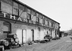 | Thames Shipyard | 1.5 miles | 1975 |
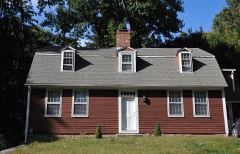 | Perkins-Bill House | 1.6 miles | 2000 |
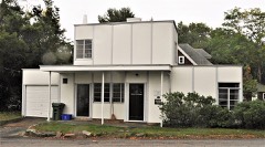 | Winslow Ames House | 1.8 miles | 1995 |
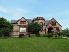 | Groton Bank Historic District | 1.8 miles | 1983 |
 | House at 130 Mohegan Avenue | 1.8 miles | 2009 |
| National Archives record | The nomination case file for reference 100011538 in Record Group 79. |
| New London County | All 197 listed properties in this county. |