Listed on the National Register of Historic Places in 2013.
From the record
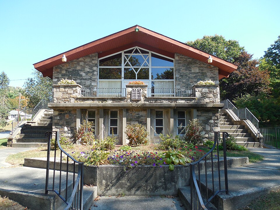
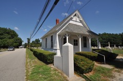
“Temple Beth Israel is an historic former Orthodox and Conservative Jewish synagogue building, located at 39 Killingly Drive in the Danielson village of Killingly, Connecticut, in the United States.”
Wikipedia article Temple Beth Israel (Danielson, Connecticut), CC BY-SA 4.0.
One of 82 National Register listings published here for Windham County · listed in 2013 · category: Building.
The first settler south of Lake Mashapaug was James Danielson, of Block Island, who in 1707 purchased of Major Fitch " the neck of land" between the Quinebaug and Assawaga rivers, for a hundred and seventy pounds. Mr. Danielson had served in the Narragansett war, and his name appears on the list of officers and soldiers who received the township of Voluntown in recompense for their services. Tradition tells us that he passed through the Whetstone country on an expedition against the Nipmucks, and stopping to rest his company on the interval between these rivers, was so well pleased with the locality that he then declared that when the war should be ended he would settle there. Nothing more is known of him until thirty years later, when he bought the land from the junction of the rivers, " extending up stream to the middle of the long interval." Tradition adds that he first traded with the natives, receiving for a trifle all that he could see from the top of a high tree, but found that Major Fitch had, forestalled him, so then he bought out his claim. Mr. Danielson at once took possession of his purchase, built a garrison house near its southern extremity and was soon known as one of the most prominent men in the new settlement. No other settler appeared in this vicinity for several years. The land south from i^cquiunk - the name given by the Indians to this locality - was held by Plainfield proprietors, under their purchase from Owaneco, and no attempt was made for many, years to bring it into market.
The settlers in this locality were few in number, but their remoteness from the seat of government and independent mode of settlement made the organization of a town government very desirable. Their deeds of land transfer had to be recorded in Hartford, Plainfield and Canterbury. In May, 1708, the assembly granted town privileges to the people here, the patent of which set forth the bounds as follows : " Northerly on the line of the Massachusetts Province (it being by estimation about) five miles from the line between this Colony and the Colony ' of Rhode Island and the river called Assawaug ; easterly on the said line between the said colonies ; southerly, partly on the northern boundary of Plainfield and partly on a line to be continued east from the northeast corner bounds of Plainfield to the said line between the said Colonies ; the said northern boundary of Plainfield being settled by order of the General Court, May the 11th, 1699, and westerly on the aforesaid river ; the said township being by estimation about eight or nine miles in length and five or six miles in breadth, be the same more or less." The men named in the patent, as representing the proprietors, were Colonel Robert Treat, Major James Fitch, Captain Dan Wetherell, Joseph Haynes, Samuel Andrew, George Denison, James Danielson, David Jacobs, Samuel Randall, Peter Aspinwall and Joseph Cady.
Regional context, not property-specific
evidence. The
federal wildfire occurrence database
lists 196 fires within 5 miles of Temple Beth Israel
between 1992 and 2020, burning about 242 acres in total. None started naturally. 27 were recorded as arson.
Distance is straight-line from the map coordinates, so a fire counted
here may appear on a neighbouring settlement's page as well.
Reported cause
Fires
Missing data/not specified/undetermined
113
Arson/incendiarism
27
Recreation and ceremony
25
Debris and open burning
13
Misuse of fire by a minor
8
Smoking
7
Railroad operations and maintenance
2
Equipment and vehicle use
1
The most recent of
them, most recent first, with the day each was reported and the service
that recorded it.
Regional context, not property-specific
evidence. The federal mineral resources record lists
14 workings within 5 miles of Temple Beth Israel: 7 past producers, 6 producers, 1 unknown.
6 still produce. What was taken out: Sand and Gravel, Construction, Stone, Crushed/Broken, Stone, Dimension, Granite. Distance is straight-line from the
map coordinates, so a quarry counted here may appear on a neighbouring
settlement's page as well.
Regional context, not property-specific
evidence. The National Weather Service names
Danielson, the town this property stands in, in 6 storm reports between 2006 and 2023: 6 thunderstorm wind.
No death or injury is recorded in these reports. Each account below is quoted exactly as the forecast office
filed it, from the NOAA Storm Events Database, and each date
opens the federal record of that event.
No historic map-sheet match is published
for this property yet. That does not mean no map exists. This record needs
a coordinate-quality review before it can be joined to a sheet boundary.
Browse the county's mapped places while that work is
pending.
Listed places nearby
6 within 8 miles
Other National Register properties close
enough to walk or drive between, ordered by distance from this one. Both
positions come from the same geocoding pass that matched these properties
to their map sheets.
Listing record. National Park Service National Register of Historic Places, listed-properties dataset, current to 2026-05-22.
Map join. Address geocoded through the United States Census geocoder, then tested against the published boundary of every sheet in the USGS Historical Topographic Map Collection.
How this page is made. Listing fields come from federal records; map-sheet coverage is a labelled coordinate-to-boundary calculation, not a source-field claim.
Wildfire. Short, Karen C. 2022. Spatial wildfire occurrence data for the United States, 1992-2020 [FPA_FOD_20221014]. 6th Edition. Fort Collins, CO: Forest Service Research Data Archive. https://doi.org/10.2737/RDS-2013-0009.6 Collected with United States Government funding and usable without additional permissions or fees.
Mines and quarries. USGS Mineral Resources Data System (MRDS) https://mrdata.usgs.gov/mrds/ A work of the United States government, no copyright under 17 U.S.C. 105.
Storms. NOAA National Centers for Environmental Information, Storm Events Database https://www.ncei.noaa.gov/stormevents/ A work of the United States government, no copyright under 17 U.S.C. 105. Narratives are quoted verbatim from the National Weather Service report and are not edited or summarised.
 Block