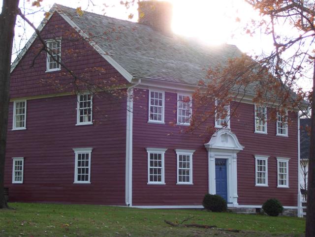
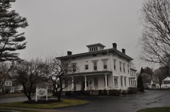
Built in 1750. Listed on the National Register of Historic Places in 1973.
From the record
“The Captain David Judson House is a historic house at 967 Academy Hill in Stratford, Connecticut. The new house was built on the stone foundation and incorporates the chimney of the original house built on the site in 1638 by Judson's great-grandfather William.”
Wikipedia article Captain David Judson House, CC BY-SA 4.0.
One of 298 National Register listings published here for Fairfield County · listed in 1973 · category: Building · built in 1750.
National Register reference number.73001946- the number the National Park Service assigned this property when it was listed, and the key its nomination file is catalogued under at the National Archives.
HE task of making this book, such as it is, is ended. The work upon it as the history of one of the oldest towns in the State, including one of the youngest and most prosperous cities, has been very attractive and entertaining, and the only regret the author has concerning it is that the income from the sale of the work would not pay for another year's labor, by which a degree of completeness, somewhat satisfactory, might have been attained. This is especially applicable to the genealogies, which in their present state are only the beginning of what might have been secured ; which is true, after all the gratuitious labor, put upon them for several years, contributed by the Rev. B. L. Swan, formerly pastor in Stratford, Bridgeport and Monroe, in which he collected a large amount of historical facts which have made the work much more complete than it otherwise would have been.
The aid received by the most cordial and continuous commendatory support of the Fairfield County Historical Society, and the financial support rendered by several of its members, have been, not only greatly helpful to the work, but without these the enterprise would have gone no further than the publication of the first one hundred and eighty pages. Much cordial friendly aid has been rendered by the town clerks, Mr. Henry P. Stagg of Stratford, and Mr. Daniel Maloney of Fairfield, they having spared no effort for the success of the work.
Regional context, not property-specific
evidence. The
federal wildfire occurrence database
lists 48 fires within 5 miles of Capt. David Judson House
between 1998 and 2020, burning about 273 acres in total. None started naturally. 6 were recorded as arson.
Distance is straight-line from the map coordinates, so a fire counted
here may appear on a neighbouring settlement's page as well.
Reported cause
Fires
Missing data/not specified/undetermined
38
Arson/incendiarism
6
Debris and open burning
2
Equipment and vehicle use
1
Fireworks
1
The most recent of
them, most recent first, with the day each was reported and the service
that recorded it.
Regional context, not property-specific
evidence. The federal mineral resources record lists
13 workings within 5 miles of Capt. David Judson House: 9 past producers, 2 unknowns, 1 occurrence, 1 plant.
1 still produces. What was taken out: Granite, Stone, Dimension, Stone, Crushed/Broken, Sand and Gravel, Construction. Distance is straight-line from the
map coordinates, so a quarry counted here may appear on a neighbouring
settlement's page as well.
Regional context, not property-specific
evidence. The National Weather Service names
Stratford, the town this property stands in, in 30 storm reports between 1993 and 2024: 14 flash flood, 11 thunderstorm wind, 2 funnel cloud, 2 hail.
The reports record 1 injury. Each account below is quoted exactly as the forecast office
filed it, from the NOAA Storm Events Database, and each date
opens the federal record of that event.
Hundreds of trees were reported down in Stratford, with the Lordship section hardest hit, with the Paradise Green section a close second. Several structures as well as a few cars were reported to have trees fall on them. One person was injured when a tree branch fell on the car they were in, and a police car had its windshield blown out by the winds.
Shingles were torn off a house near the corner of Nichols Road and North Avenue. This damage marked the southwest end of a 0.8 mile wide damage swath that extended northeast to Wilcoxson and Main, where trees were down. The microburst then traveled southeast to the mouth of the Housatonic River, downing dozens of trees and power lines, including some on top of vehicles.
A large tree was uprooted and a large shed picked up by winds and dropped on top of another shed 6 feet away in the Success Hill section of Bridgeport.
Multiple roads were closed due to flooding in Bridgeport including the intersections of Bishop Avenue and Connecticut Avenue, Lincoln Avenue and Arlington Street, Gregory Street and Columbia Street, East Washington Street and East Main Street, and Seaview Avenue at the I-95 exit ramp.
Many roads on the east side of Bridgeport were flooded. There were road closures and property damage due to the flooding. The intersection of Arctic St. and Pembroke St. had several inches of water on it, which also covered the side walks.
Severe flooding occurred on Terrill Rd. in Stratford. Water levels were approximately 2 feet high with residents using kayaks and other floatation devices on the street to manuver through the high waters.
A car was stranded in high waters under a flooded viaduct at East Main St. and Crescent Ave. in Bridgeport. The 2 occupants (an adult and a child) were rescued by local firefighters. A new school on Waterview Ave. in Bridgeport was also flooded.
A gust to 59 mph was recorded at the Sikorsky Memorial Airport National Weather Service Office in Stratford. One small plane flipped over. Additionally, considerable tree and power line damage was reported in Greenwich and Darien by Darien Police.
No historic map-sheet match is published
for this property yet. That does not mean no map exists. This record needs
a coordinate-quality review before it can be joined to a sheet boundary.
Browse the county's mapped places while that work is
pending.
Listed places nearby
6 within 8 miles
Other National Register properties close
enough to walk or drive between, ordered by distance from this one. Both
positions come from the same geocoding pass that matched these properties
to their map sheets.
Listing record. National Park Service National Register of Historic Places, listed-properties dataset, current to 2026-05-22.
Map join. Address geocoded through the United States Census geocoder, then tested against the published boundary of every sheet in the USGS Historical Topographic Map Collection.
How this page is made. Listing fields come from federal records; map-sheet coverage is a labelled coordinate-to-boundary calculation, not a source-field claim.
Wildfire. Short, Karen C. 2022. Spatial wildfire occurrence data for the United States, 1992-2020 [FPA_FOD_20221014]. 6th Edition. Fort Collins, CO: Forest Service Research Data Archive. https://doi.org/10.2737/RDS-2013-0009.6 Collected with United States Government funding and usable without additional permissions or fees.
Mines and quarries. USGS Mineral Resources Data System (MRDS) https://mrdata.usgs.gov/mrds/ A work of the United States government, no copyright under 17 U.S.C. 105.
Storms. NOAA National Centers for Environmental Information, Storm Events Database https://www.ncei.noaa.gov/stormevents/ A work of the United States government, no copyright under 17 U.S.C. 105. Narratives are quoted verbatim from the National Weather Service report and are not edited or summarised.
 Block