BlockBefore
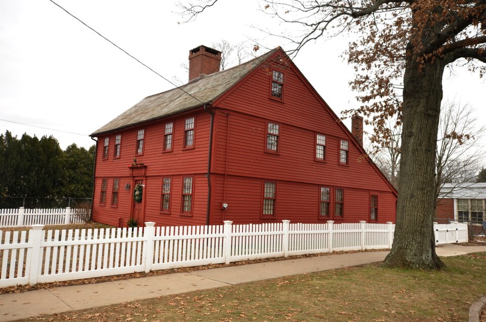
Photograph of Moses Andrews House
Photograph by Magicpiano, CC BY-SA 4.0. Via Wikimedia Commons.

Moses Andrews House

Listed on the National Register of Historic Places in 1978.

From the record

“The Moses Andrews House is a historic house museum at 424 West Main Street in Meriden, Connecticut. Built about 1760, it is one of a small number of surviving 18th-century houses in the city.”

Wikipedia article Moses Andrews House, CC BY-SA 4.0.

One of 272 National Register listings published here for New Haven County · listed in 1978 · category: Building.

Sources: the Wikipedia article · the case file at the National Archives · the National Register database, National Park Service

The listing

  • What is counted as historic. The nomination lists 1 building as contributing to the listing.
  • Listed as. Andrews, Moses, House - the National Register files a house under its owner's surname.
  • Address. 424 W. Main St., Meriden, 06451
  • When was it listed? December 1978
  • Category. building
  • Town. Meriden town
  • National Register reference number. 78002859 - the number the National Park Service assigned this property when it was listed, and the key its nomination file is catalogued under at the National Archives.

Fires near this property

55 since 1996

Regional context, not property-specific evidence. The federal wildfire occurrence database lists 55 fires within 5 miles of Moses Andrews House between 1996 and 2020, burning about 36 acres in total. None started naturally. 6 were recorded as arson. Distance is straight-line from the map coordinates, so a fire counted here may appear on a neighbouring settlement's page as well.

Reported cause Fires
Missing data/not specified/undetermined36
Arson/incendiarism6
Misuse of fire by a minor4
Recreation and ceremony3
Debris and open burning2
Smoking1
Other causes1
Fireworks1
Equipment and vehicle use1

The most recent of them, most recent first, with the day each was reported and the service that recorded it.

DateCause SizeReported by Name on the report
24 September 2017Missing data/not specified/undeterminedunder an acreConnecticut Division of ForestryRTE. 5 AND NORTH COLONY DRIVE
17 September 2017Missing data/not specified/undeterminedunder an acreConnecticut Division of Forestry600 MERIDEN RD.
3 August 2015Other causesunder an acreConnecticut Division of Forestrynot named
2 August 1999Missing data/not specified/undeterminedunder an acreConnecticut Division of Forestrynot named
18 August 2002Missing data/not specified/undetermined2.0 acresConnecticut Division of Forestrynot named
15 August 2020Missing data/not specified/undeterminedunder an acreConnecticut Division of Forestry126 KICKAPOO ROAD
14 August 2020Missing data/not specified/undeterminedunder an acreConnecticut Division of Forestry99 MATTABESECK ROAD
10 August 2001Missing data/not specified/undeterminedunder an acreConnecticut Division of Forestrynot named

Every fire recorded in New Haven County

Mines and quarries near this property

10 of 31 shown

Regional context, not property-specific evidence. The federal mineral resources record lists 31 workings within 5 miles of Moses Andrews House: 25 past producers, 4 producers, 1 occurrence, 1 unknown. 4 still produce. What was taken out: Barium-Barite, Copper, Stone, Crushed/Broken, Stone, Dimension. Distance is straight-line from the map coordinates, so a quarry counted here may appear on a neighbouring settlement's page as well.

Where SiteCommodity StatusRecorded
Bellamy Copper Valley MineSulfur, Copper, Barium-BaritePast ProducerVoid Filling And Replacement
New Haven Mineral Co. Barite MineBarium-Barite, Copper, Silver, StrontiumPast ProducerBarite
Sandstone QuarryFlagstonePast Producer
Cheshire North Haven PitSand and Gravel, ConstructionProducer
Meridan-Wallingford MineSand and Gravel, ConstructionPast ProducerSedimentary
Meridan-Wallingford MineSand and Gravel, ConstructionProducer
Basalt Rock Quarry No. Dj-0Stone, DimensionPast Producer
Bellamy-Copper Valley MineCopperPast Producer
Brownstone Sandstone Rock Quarries No. Dj-037Stone, DimensionPast Producer

Every working recorded in New Haven County

Storms near this property

19 since 1995

Regional context, not property-specific evidence. The National Weather Service names Meriden, the town this property stands in, in 19 storm reports between 1995 and 2024: 9 thunderstorm wind, 4 hail, 3 flash flood, 2 lightning. No death or injury is recorded in these reports. Each account below is quoted exactly as the forecast office filed it, from the NOAA Storm Events Database, and each date opens the federal record of that event.

WhenEvent Place namedHarm What the report says
July 2009Thunderstorm WindMeriden$7,500Main Street was closed due to multiple trees down across the road.
August 2013Thunderstorm WindMeriden$3,000A few trees were reported down on I-691 in Meriden.
June 2011LightningMeriden$3,000Numerous lightning strikes were reported in Meriden.
May 2010Thunderstorm WindMeriden$3,000Numerous trees and power lines were downed due to a gust front.
June 2015Thunderstorm WindMeriden$2,000A large tree was reported down, blocking Mayflower Lane.
July 2008Thunderstorm WindMeriden$2,000Trees and wires were downed along the I-691 corridor.
June 2009Thunderstorm WindMeriden$1,000Two power lines were downed at 63 Elizabeth Road.
May 2010Thunderstorm WindMeriden$200A large tree branch was downed by severe winds.
May 2010Thunderstorm WindMeriden$200A large tree branch was downed.
August 2024HailMeriden-Multiple reports and pictures from Wallingford of 1.00 inch to 1.50 inch hail.
September 2021Flash FloodMeriden-A car was partially submerged in flood waters on Mill Street near State Street in Meriden. Mill Street was closed due to heavy flooding.
July 2021Flash FloodMeriden-Flowing flood waters up the the hood of cars were reported on Cook Avenue in Meriden.
December 2018Flash FloodMeriden-Route 15 was closed northbound at Exit 68W in Meriden due to flooding.
August 2008HailMeriden-Quarter size hail was reported near the intersection of I-91 and I-691.
February 2008FloodMeriden-Hanover Street to Cook Avenue closed due to flooding.
July 2012HailMeriden-no account filed
July 1998Thunderstorm WindMeriden-no account filed
August 1997LightningMeriden-no account filed
July 1995HailMeriden-no account filed

Every storm recorded in New Haven County

Map coverage status

No historic map-sheet match is published for this property yet. That does not mean no map exists. This record needs a coordinate-quality review before it can be joined to a sheet boundary. Browse the county's mapped places while that work is pending.

Listed places nearby

6 within 8 miles

Other National Register properties close enough to walk or drive between, ordered by distance from this one. Both positions come from the same geocoding pass that matched these properties to their map sheets.

Sources for this property

National Archives recordThe nomination case file for reference 78002859 in Record Group 79.
Wikipedia articleCommunity-written account of this property, licensed CC BY-SA.
New Haven CountyAll 272 listed properties in this county.

Provenance

  • Listing record. National Park Service National Register of Historic Places, listed-properties dataset, current to 2026-05-22.
  • Map join. Address geocoded through the United States Census geocoder, then tested against the published boundary of every sheet in the USGS Historical Topographic Map Collection.
  • How this page is made. Listing fields come from federal records; map-sheet coverage is a labelled coordinate-to-boundary calculation, not a source-field claim.
  • Wildfire. Short, Karen C. 2022. Spatial wildfire occurrence data for the United States, 1992-2020 [FPA_FOD_20221014]. 6th Edition. Fort Collins, CO: Forest Service Research Data Archive. https://doi.org/10.2737/RDS-2013-0009.6 Collected with United States Government funding and usable without additional permissions or fees.
  • Mines and quarries. USGS Mineral Resources Data System (MRDS) https://mrdata.usgs.gov/mrds/ A work of the United States government, no copyright under 17 U.S.C. 105.
  • Storms. NOAA National Centers for Environmental Information, Storm Events Database https://www.ncei.noaa.gov/stormevents/ A work of the United States government, no copyright under 17 U.S.C. 105. Narratives are quoted verbatim from the National Weather Service report and are not edited or summarised.