BlockBefore
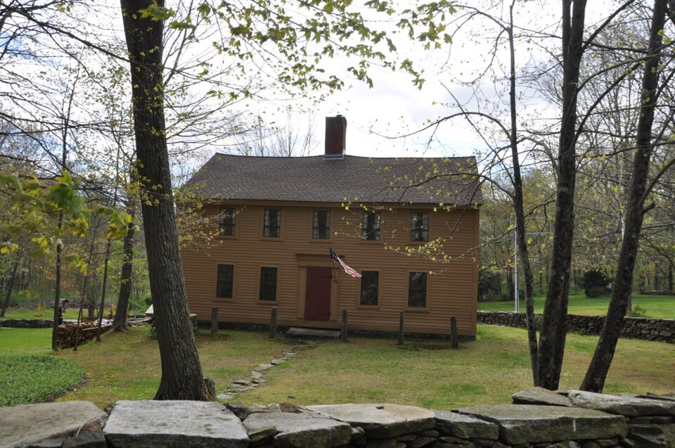
Photograph of John Cady House
Photograph by User:Magicpiano, CC BY-SA 4.0. Via Wikimedia Commons.

John Cady House

Listed on the National Register of Historic Places in 1982.

From the record

“The John Cady House, also known historically as the Babcock Tavern, is a historic house at 484 Mile Hill Road in Tolland, Connecticut. With a distinctive construction history dating to 1753, it serves as an important window into the construction methods and techniques of the 18th and 19th centuries.”

Wikipedia article John Cady House, CC BY-SA 4.0.

One of 47 National Register listings published here for Tolland County · listed in 1982 · category: Building.

Sources: the Wikipedia article · the case file at the National Archives · the National Register database, National Park Service

The listing

  • What is counted as historic. The nomination lists 1 building as contributing to the listing.
  • Listed as. Cady, John, House - the National Register files a house under its owner's surname.
  • Address. 484 Mile Hill Rd., Tolland, 06084
  • When was it listed? April 1982
  • Category. building
  • Town. Tolland town
  • National Register reference number. 82004390 - the number the National Park Service assigned this property when it was listed, and the key its nomination file is catalogued under at the National Archives.

Fires near this property

176 since 1992

Regional context, not property-specific evidence. The federal wildfire occurrence database lists 176 fires within 5 miles of John Cady House between 1992 and 2020, burning about 228 acres in total. None started naturally. 7 were recorded as arson. Distance is straight-line from the map coordinates, so a fire counted here may appear on a neighbouring settlement's page as well.

Reported cause Fires
Missing data/not specified/undetermined127
Recreation and ceremony13
Debris and open burning12
Smoking10
Arson/incendiarism7
Equipment and vehicle use4
Power generation/transmission/distribution2
Misuse of fire by a minor1

The most recent of them, most recent first, with the day each was reported and the service that recorded it.

DateCause SizeReported by Name on the report
5 September 2016Missing data/not specified/undeterminedunder an acreConnecticut Division of Forestry255 TOLLAND STAGE RD TOLLAND CT
3 September 2011Missing data/not specified/undeterminedunder an acreConnecticut Division of ForestryTOLLAND
25 September 2019Missing data/not specified/undeterminedunder an acreConnecticut Division of Forestrynot named
24 September 2009Recreation and ceremonyunder an acreConnecticut Division of Forestrynot named
14 September 2015Missing data/not specified/undeterminedunder an acreConnecticut Division of Forestrynot named
14 September 2009Missing data/not specified/undeterminedunder an acreConnecticut Division of Forestrynot named
7 August 2016Missing data/not specified/undeterminedunder an acreConnecticut Division of Forestry347 TOLLAND STAGE RD TOLLAND CT
4 August 2015Missing data/not specified/undeterminedunder an acreConnecticut Division of Forestrynot named

Every fire recorded in Tolland County

Mines and quarries near this property

10 of 15 shown

Regional context, not property-specific evidence. The federal mineral resources record lists 15 workings within 5 miles of John Cady House: 8 past producers, 6 producers, 1 unknown. 6 still produce. What was taken out: Stone, Dimension, Stone, Crushed/Broken, Sand and Gravel, Construction. Distance is straight-line from the map coordinates, so a quarry counted here may appear on a neighbouring settlement's page as well.

Where SiteCommodity StatusRecorded
Coventry PitSand and Gravel, ConstructionPast Producer
Bolton Notch QuarryStone, Crushed/BrokenProducer
Tolland QuarryStone, Crushed/BrokenUnknown
Box Mountain QuarryStone, DimensionProducer
Burgund Hill QuarriesStone, DimensionPast Producer
Flaggy Quartzite Rock Quarry No. Bi-008Stone, DimensionProducer
Flaggy Quartzite Rock Quarry No. Bi-009Stone, DimensionProducer
Flaggy Quartzite Rock Quarry No. Bi-010Stone, DimensionProducer1945
Flaggy Quartzite Rock Quarry No. Bi-011Stone, DimensionPast Producer1843
Flaggy Quartzite Rock Quarry No. Bi-012Stone, DimensionProducer

Every working recorded in Tolland County

Storms near this property

36 since 1994

Regional context, not property-specific evidence. The National Weather Service names Tolland, the town this property stands in, in 36 storm reports between 1994 and 2024: 27 thunderstorm wind, 8 hail, 1 heavy rain. No death or injury is recorded in these reports. Each account below is quoted exactly as the forecast office filed it, from the NOAA Storm Events Database, and each date opens the federal record of that event.

WhenEvent Place namedHarm What the report says
July 2014Thunderstorm WindTolland$50,000A microburst occurred with winds 80-90 mph downing numerous trees and wires on Interstate 195, Goose Lane, and Cedar Mill, Reed and Mile Hill Roads.
July 2016Thunderstorm WindTolland$30,000Trees and wires on Apple Road, Glenn View Terrace, Gehring Road, and Shenipsit Lake Road were downed by thunderstorm winds. One of these trees was downed onto a house.
June 2012Thunderstorm WindTolland$30,000Trees and wires on Route 30, Doyle Road, and Robin Circle were downed by thunderstorm winds.
July 2013Thunderstorm WindTolland$25,000A severe thunderstorm downed several trees and large branches on Mountain Spring Road in Tolland. While several eyewitnesses reported seeing a funnel cloud, the survey team found no evidence of a tornado touching down. All of the downed trees were blown down in the same direction indicating straight line winds.
May 2010Thunderstorm WindTolland$15,000Trees were downed by thunderstorm winds, blocking a road.
June 2010Thunderstorm WindTolland$15,000A tree and utility pole on Route 83 were downed by thunderstorm winds. In addition, wires were downed in parts of town. An amateur radio operator recorded a wind gust of 58 mph on their home weather station.
February 2016Thunderstorm WindTolland$10,000Trees and wires were downed by severe thunderstorm winds.
July 2014Thunderstorm WindTolland$10,000Trees and wires were downed on Merrow Road in Tolland.
June 2012Thunderstorm WindTolland$10,000A tree and wires were downed by thunderstorm winds on Crystal Lake Road and Old Post Road.
September 2012Thunderstorm WindTolland$10,000Trees and wires were downed on Woodland Street and the intersection of Reed Road and Timber Trail.
August 2006Thunderstorm WindTolland$10,000no account filed
July 2008Thunderstorm WindTolland$8,000Trees and wires on Melissa Way and Tolland Stage Road were downed by thunderstorm winds.
September 2008Thunderstorm WindTolland$8,000Multiple trees and wires on Routes 74 and 195 were downed by thunderstorm winds.
February 2016Thunderstorm WindTolland$5,000Power lines on Anthony Road between Virginia Lane and Rhodes Road in Tolland were downed by thunderstorm winds.
June 2013Thunderstorm WindTolland$5,000A tree and wires on Mountain Spring Road were downed by thunderstorm winds.
November 2013Thunderstorm WindTolland$5,000A tree was downed onto wires on Loehr Road by thunderstorm winds.
September 2012Thunderstorm WindTolland$5,000Wires on Clark Road were downed by thunderstorm winds.
June 2020Thunderstorm WindTolland$2,500In Tolland, trees and wires were down on Old Post Road. Trees and wires also were down on Sugar Hill Road.
September 2018Thunderstorm WindTolland$2,000At 3:20 PM EST, wind brought a tree and wires down on Skungamaug Road in Tolland.
July 2020Thunderstorm WindTolland$1,600In Tolland, trees and wires were down on both Grandview Street and Weigold Road.
June 2024Thunderstorm WindTolland$1,500In Tolland, several trees and large limbs were down in town on South River Rd and Merrow Rd.
July 2023Thunderstorm WindTolland$1,300In Tolland, trees were down on wires on an unspecified street. Report relayed by amateur radio.
June 2021Thunderstorm WindTolland$1,300In Tolland, trees and wires were down on Rhodes Road.
July 2022Thunderstorm WindTolland$800In Tolland, the Fire Dept. reported a tree down on wires on Pilgrim Drive. Report relayed via amateur radio.
August 2022Thunderstorm WindTolland$500In Tolland, a tree was down on wires on Goose Lane.
September 2019HailTolland-Quarter size hail was reported in Tolland.
April 1995Thunderstorm WindTolland-Lots of trees and power lines were blown down in the city of Tolland, as reported by the local police.
June 1994HailTolland-Dime-size hail was reported.
August 1994Thunderstorm WindTolland-Many trees were reported blown down.
June 2012HailTolland-no account filed
May 2010HailTolland-no account filed
June 2010HailTolland-no account filed
August 2006HailTolland-no account filed
June 2001HailTolland-no account filed
August 1996Heavy RainTolland-no account filed

Every storm recorded in Tolland County

Map coverage status

No historic map-sheet match is published for this property yet. That does not mean no map exists. This record needs a coordinate-quality review before it can be joined to a sheet boundary. Browse the county's mapped places while that work is pending.

Listed places nearby

6 within 8 miles

Other National Register properties close enough to walk or drive between, ordered by distance from this one. Both positions come from the same geocoding pass that matched these properties to their map sheets.

Photograph PropertyDistance Listed
Loomis-Pomeroy House2.6 miles1994
Minterburn Mill3.1 miles1984
Tolland Green Historic District3.2 miles1997
Tolland County Courthouse3.2 miles1977
Coventry Glass Factory Historic District3.4 miles1987
Rockville Historic District3.5 miles1984

Sources for this property

National Archives recordThe nomination case file for reference 82004390 in Record Group 79.
Wikipedia articleCommunity-written account of this property, licensed CC BY-SA.
Tolland CountyAll 47 listed properties in this county.

Provenance

  • Listing record. National Park Service National Register of Historic Places, listed-properties dataset, current to 2026-05-22.
  • Map join. Address geocoded through the United States Census geocoder, then tested against the published boundary of every sheet in the USGS Historical Topographic Map Collection.
  • How this page is made. Listing fields come from federal records; map-sheet coverage is a labelled coordinate-to-boundary calculation, not a source-field claim.
  • Wildfire. Short, Karen C. 2022. Spatial wildfire occurrence data for the United States, 1992-2020 [FPA_FOD_20221014]. 6th Edition. Fort Collins, CO: Forest Service Research Data Archive. https://doi.org/10.2737/RDS-2013-0009.6 Collected with United States Government funding and usable without additional permissions or fees.
  • Mines and quarries. USGS Mineral Resources Data System (MRDS) https://mrdata.usgs.gov/mrds/ A work of the United States government, no copyright under 17 U.S.C. 105.
  • Storms. NOAA National Centers for Environmental Information, Storm Events Database https://www.ncei.noaa.gov/stormevents/ A work of the United States government, no copyright under 17 U.S.C. 105. Narratives are quoted verbatim from the National Weather Service report and are not edited or summarised.