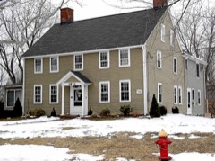
Listed on the National Register of Historic Places in 1982.
From the record
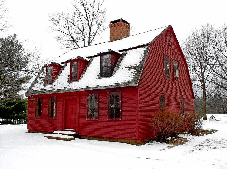
“The Makens Bemont House, commonly called the Huguenot House, is a historic house museum at 307 Burnside Avenue in East Hartford, Connecticut. Built in 1761, it is one of the town's few surviving 18th-century buildings, and is one of several buildings located in Martin Park that are operated by the Historical Society of East Hartford as the Historical Houses at Martin Park.”
Wikipedia article Makens Bemont House, CC BY-SA 4.0.
One of 451 National Register listings published here for Hartford County · listed in 1982 · category: Building.
National Register reference number.82004397- the number the National Park Service assigned this property when it was listed, and the key its nomination file is catalogued under at the National Archives.
The town of Hartford once included in its l)oundaries the territory of the present towns of East Hartford and Manchester. Deeds from the Indians of all its land have been preserved, excepting of the territory now covered by East Hartford. A deed of this was probably given, as allusions to its purchase occur in the records of early lay-outs and distributions of the land. The history of this territory (long known as the " three miles " tract), and of the " five miles " purchase, made later, is included in that of Hartford until 1783, when these two sections were made a separate town, Avith bounds extending from the Great River to the Bolton town line, and known as East Hartford. The original boundary of the town of Plartford on this side the river on the south waj5 " att the' mouth of Pewter pott Brooke att the lower side of Hoccano, and there to run due east into the Country 3 miles;" and on the north, at " the Riverett's mouth [l)y the Indians called Podanke] that falls into the saide greate River of" Conectecott, and there the said Hartford is to runn due east into the Countrey."
The petition of the inhal)itants asking for the " liberty of a minister" among them was dated May, 1694, and in October of that year permission was given. The society was known as the Third Ecclesiastical Society of Hartford, and included all of the town of Hartford on this side the Great River, - now the towns of East Hartford and Manchester. All persons living on this side were to pay their rates toward its maintenance. The earliest preserved record of a meeting is of one held Dec. 29, 1699, wdien a committee was appointed " to see about the meeting-house" - probably already begun. A rate of threepence in the pound was laid, - one penny payalde in corn, the rest in work if any chose. The meetinii-house was built on a little hill which once hlled the triangle formed by the roads at the north end of the Hockanum causeway. It was not fully completed for several years. In 1707 a rate of <£45 was voted for -' seating- and sealing- " the meeting-house, two thirds payable in timber delivered at the water side of the meeting-house. In 1713 galleries were built, and in 1718 four green casements ordered for the south windows. The structure was very plain, and was used until about 1740. A minister's house was begun in 1699, and a rate of £200 was laid to com]:)leto it. It was built on the west side of Main Street, not far from the meeting-house.
Regional context, not property-specific
evidence. The
federal wildfire occurrence database
lists 13 fires within 5 miles of Makens Bemont House
between 1992 and 2020, burning about 210 acres in total. None started naturally. 4 were recorded as arson.
Distance is straight-line from the map coordinates, so a fire counted
here may appear on a neighbouring settlement's page as well.
Reported cause
Fires
Missing data/not specified/undetermined
5
Arson/incendiarism
4
Recreation and ceremony
1
Smoking
1
Debris and open burning
1
Power generation/transmission/distribution
1
The most recent of
them, most recent first, with the day each was reported and the service
that recorded it.
Regional context, not property-specific
evidence. The federal mineral resources record lists
21 workings within 5 miles of Makens Bemont House: 11 past producers, 8 producers, 2 plants.
10 still produce. What was taken out: Sand and Gravel, Construction, Clay, Stone, Dimension, Flagstone. Distance is straight-line from the
map coordinates, so a quarry counted here may appear on a neighbouring
settlement's page as well.
Regional context, not property-specific
evidence. The National Weather Service names
East Hartford, the town this property stands in, in 8 storm reports between 1996 and 2021: 5 thunderstorm wind, 3 flash flood.
No death or injury is recorded in these reports. Each account below is quoted exactly as the forecast office
filed it, from the NOAA Storm Events Database, and each date
opens the federal record of that event.
In East Hartford, Willow Brook went out of its banks, inundating parking lots and roadways at Rentschler Field at Pratt & Whitney Stadium. Roads and buildings also were flooded elsewhere in town, including several homes.
No historic map-sheet match is published
for this property yet. That does not mean no map exists. This record needs
a coordinate-quality review before it can be joined to a sheet boundary.
Browse the county's mapped places while that work is
pending.
Listed places nearby
6 within 8 miles
Other National Register properties close
enough to walk or drive between, ordered by distance from this one. Both
positions come from the same geocoding pass that matched these properties
to their map sheets.
Listing record. National Park Service National Register of Historic Places, listed-properties dataset, current to 2026-05-22.
Map join. Address geocoded through the United States Census geocoder, then tested against the published boundary of every sheet in the USGS Historical Topographic Map Collection.
How this page is made. Listing fields come from federal records; map-sheet coverage is a labelled coordinate-to-boundary calculation, not a source-field claim.
Wildfire. Short, Karen C. 2022. Spatial wildfire occurrence data for the United States, 1992-2020 [FPA_FOD_20221014]. 6th Edition. Fort Collins, CO: Forest Service Research Data Archive. https://doi.org/10.2737/RDS-2013-0009.6 Collected with United States Government funding and usable without additional permissions or fees.
Mines and quarries. USGS Mineral Resources Data System (MRDS) https://mrdata.usgs.gov/mrds/ A work of the United States government, no copyright under 17 U.S.C. 105.
Storms. NOAA National Centers for Environmental Information, Storm Events Database https://www.ncei.noaa.gov/stormevents/ A work of the United States government, no copyright under 17 U.S.C. 105. Narratives are quoted verbatim from the National Weather Service report and are not edited or summarised.
 Block