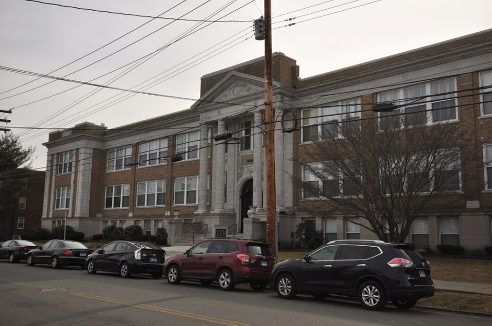
Built in 1926 (Neoclassical architecture). Listed on the National Register of Historic Places in 1985.
From the record
“The Old West Haven High School is a historic former school building at 278 Main Street in West Haven, Connecticut. Built in 1926 during a period of rapid population growth, it served the city as a high school and then junior high school until 1983.”
Wikipedia article Old West Haven High School, CC BY-SA 4.0.
One of 272 National Register listings published here for New Haven County · listed in 1985 · category: Building · built in 1926, Neoclassical architecture.
National Register reference number.85003368- the number the National Park Service assigned this property when it was listed, and the key its nomination file is catalogued under at the National Archives.
Fires near this property
151 since 1993
Regional context, not property-specific
evidence. The
federal wildfire occurrence database
lists 151 fires within 5 miles of Old West Haven High School
between 1993 and 2020, burning about 114 acres in total. None started naturally. 8 were recorded as arson.
Distance is straight-line from the map coordinates, so a fire counted
here may appear on a neighbouring settlement's page as well.
Reported cause
Fires
Missing data/not specified/undetermined
115
Debris and open burning
12
Smoking
10
Arson/incendiarism
8
Misuse of fire by a minor
2
Equipment and vehicle use
2
Recreation and ceremony
2
The most recent of
them, most recent first, with the day each was reported and the service
that recorded it.
Regional context, not property-specific
evidence. The federal mineral resources record lists
28 workings within 5 miles of Old West Haven High School: 19 past producers, 8 producers, 1 plant.
9 still produce. What was taken out: Stone, Crushed/Broken, Stone, Dimension, Limestone, General, Gold. Distance is straight-line from the
map coordinates, so a quarry counted here may appear on a neighbouring
settlement's page as well.
Regional context, not property-specific
evidence. The National Weather Service names
West Haven, the town this property stands in, in 7 storm reports between 2001 and 2020: 3 thunderstorm wind, 2 hail, 2 flash flood.
No death or injury is recorded in these reports. Each account below is quoted exactly as the forecast office
filed it, from the NOAA Storm Events Database, and each date
opens the federal record of that event.
No historic map-sheet match is published
for this property yet. That does not mean no map exists. This record needs
a coordinate-quality review before it can be joined to a sheet boundary.
Browse the county's mapped places while that work is
pending.
Listed places nearby
6 within 8 miles
Other National Register properties close
enough to walk or drive between, ordered by distance from this one. Both
positions come from the same geocoding pass that matched these properties
to their map sheets.
Listing record. National Park Service National Register of Historic Places, listed-properties dataset, current to 2026-05-22.
Map join. Address geocoded through the United States Census geocoder, then tested against the published boundary of every sheet in the USGS Historical Topographic Map Collection.
How this page is made. Listing fields come from federal records; map-sheet coverage is a labelled coordinate-to-boundary calculation, not a source-field claim.
Wildfire. Short, Karen C. 2022. Spatial wildfire occurrence data for the United States, 1992-2020 [FPA_FOD_20221014]. 6th Edition. Fort Collins, CO: Forest Service Research Data Archive. https://doi.org/10.2737/RDS-2013-0009.6 Collected with United States Government funding and usable without additional permissions or fees.
Mines and quarries. USGS Mineral Resources Data System (MRDS) https://mrdata.usgs.gov/mrds/ A work of the United States government, no copyright under 17 U.S.C. 105.
Storms. NOAA National Centers for Environmental Information, Storm Events Database https://www.ncei.noaa.gov/stormevents/ A work of the United States government, no copyright under 17 U.S.C. 105. Narratives are quoted verbatim from the National Weather Service report and are not edited or summarised.
 Block