BlockBefore
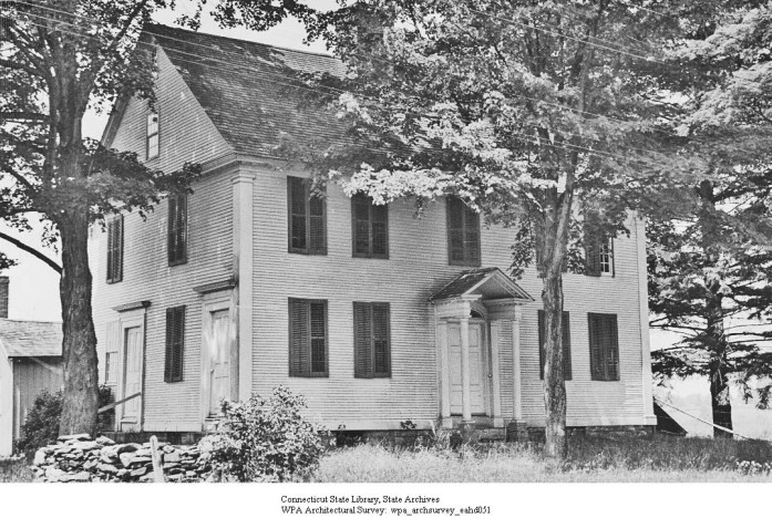
Photograph of Warner House
Photograph by WPA Architectural Survey, Public domain. Via Wikimedia Commons.

Warner House

Listed on the National Register of Historic Places in 1987.

From the record

“The Warner House is a historic house at 307 Town Street in East Haddam, Connecticut. Built in 1738, it is notable for its high quality interior woodwork and hardware, the latter of which were probably made by some of its owners.”

Wikipedia article Warner House (East Haddam, Connecticut), CC BY-SA 4.0.

One of 124 National Register listings published here for Middlesex County · listed in 1987 · category: Building.

Sources: the Wikipedia article · the case file at the National Archives · the National Register database, National Park Service · the Wikipedia article
The listing

  • Address. 307 Town St., East Haddam, 06423
  • When was it listed? February 1987
  • Category. building
  • Town. East Haddam town
  • National Register reference number. 87000174 - the number the National Park Service assigned this property when it was listed, and the key its nomination file is catalogued under at the National Archives.

The ground it stands on

43,998 words

The chapter on East Haddam Town in History of Middlesex County, Connecticut, with Biographical Sketches of Its Prominent Men, published 1884 names East Haddam. This is what it says, exactly as the scans read.

A tract of land, of which East Haddam is a part, extending from Chatham line to Chester Cove, reaching six miles easterly and westerly from the river, was purchased from four Indian kings, in 1662, for 30 coats, of a value not exceeding $100. The tract thus purchased was taken up by 28 persons, mostly young men from the vicinity of Hartford, who settled on the northern part of this land on the west side of the river. Barber says their names were Ackley, Arnold, Bailey, Brainerd, Brooks, Clarke, Cone, Gates, Shayler, two Spencers, two Smiths, Ventres, Wells, Bates, Butler, Corbe, Dibble, Ganes, Hannison, Jones, Luxford, Parents, Piper, Stan nard, Webb, and Wiat.

Passage source: History of Middlesex County, Connecticut, with Biographical Sketches of Its Prominent Men, published 1884.

About six years afterward, the privileges of a town were granted this colony, and the tract was called Haddam, from Haddam in England. This was about tlie zoth town founded in the State. No settlement was made on the east side of the river till some two years later, or about 1670. All the inhabitants on both sides of the river formed one society until 1700, when they formed two societies, but it was not till 1734 that the town was divided agreeably to the divisions of the societies; the west society retaining the name of Haddam, while the east took the name of East Haddam. The first settlement of East Haddam was begun at Creek Row, about the year 1670, more than 200 years ago. The first house, it is said, stood a few rods northeast of the site where Mason Gates' house now stands. Quite a number of houses were erected in this vicinity, and were occupied by the Gates, the Brainerds, and the Cones, and the same family names are peculiar to this neighborhood. Field, in his history, claims that the settlement at the Creek Row commenced in 1685; which appears to be an error, as from a document found in the colony records, it is certain that " Robert Chapman had a dwelling-house in East Haddam, north of the Creek Row, in 1674." It seems to be conceded on all sides that the settlement at Creek Row was first; then it must have commenced as early as 1670. Besides, as the land was purchased, and the settlement commenced in Haddam in 1662, it is hardly supposable that 23 years would pass by before any attempt was made to settle the east side of the river.

Passage source: History of Middlesex County, Connecticut, with Biographical Sketches of Its Prominent Men, published 1884.

Machine-read from a century-old scan, so expect the errors a machine makes: misspelled names, dropped words, stray characters.

Read the whole chapter on East Haddam Town - 43,998 words on its settlement, mills, schools and churches.

Fires near this property

257 since 1992

Regional context, not property-specific evidence. The federal wildfire occurrence database lists 257 fires within 5 miles of Warner House between 1992 and 2020, burning about 458 acres in total. 1 started naturally. 3 were recorded as arson. Distance is straight-line from the map coordinates, so a fire counted here may appear on a neighbouring settlement's page as well.

Reported cause Fires
Missing data/not specified/undetermined140
Recreation and ceremony37
Debris and open burning37
Misuse of fire by a minor19
Smoking10
Equipment and vehicle use5
Arson/incendiarism3
Railroad operations and maintenance2
Other causes1
Natural1
Power generation/transmission/distribution1
Fireworks1

The most recent of them, most recent first, with the day each was reported and the service that recorded it.

DateCause SizeReported by Name on the report
8 September 2015Arson/incendiarism10 acresConnecticut Division of Forestrynot named
6 September 2015Recreation and ceremony1.0 acresConnecticut Division of Forestrynot named
5 September 2015Debris and open burningunder an acreConnecticut Division of Forestrynot named
3 September 2019Missing data/not specified/undeterminedunder an acreConnecticut Division of Forestrynot named
22 September 2019Missing data/not specified/undeterminedunder an acreConnecticut Division of Forestrynot named
2 September 2017Recreation and ceremonyunder an acreConnecticut Division of Forestry81 SCHULMAN VESELAK
26 August 2017Missing data/not specified/undeterminedunder an acreConnecticut Division of ForestryNUCCI LANE
26 August 2010Missing data/not specified/undetermined1.0 acresConnecticut Division of Forestrynot named

Every fire recorded in Middlesex County

Mines and quarries near this property

10 of 22 shown

Regional context, not property-specific evidence. The federal mineral resources record lists 22 workings within 5 miles of Warner House: 18 past producers, 2 producers, 1 occurrence, 1 prospect. 2 still produce. What was taken out: Granite, Stone, Dimension, Feldspar, Beryllium. Distance is straight-line from the map coordinates, so a quarry counted here may appear on a neighbouring settlement's page as well.

Where SiteCommodity StatusRecorded
Arnold Pegmatite QuarryFeldspar, QuartzProducer
Bainerd QuarryFeldspar, Mica, BerylliumPast Producer
Gillette Gem Tourmaline, Mineral Specimens, Mica, Feldspar Mine (AlsoGemstone, Mica, FeldsparPast Producer1896
Gillette QuarryTin, Feldspar, Semiprecious Gemstone, MicaPast Producer1896
Granitic Gneiss Rock Quarry No. Cj-061StonePast ProducerGneiss
Connecticut Valley Sand and StoneSand and Gravel, ConstructionProducer
Haddam Pit Hood & Smith PitSand and Gravel, ConstructionPast Producer
Hood and Smith Sand & Gravel PitSand and Gravel, ConstructionPast ProducerSedimentary
Mt. Tom Beryl ProspectBerylliumOccurrencePegmatite Dike
Mt. Tom Beryl ProspectBerylliumProspect

Every working recorded in Middlesex County

Storms near this property

2 since 1998

Regional context, not property-specific evidence. The National Weather Service names East Haddam, the town this property stands in, in 2 storm reports between 1998 and 2004: 1 lightning, 1 hail. No death or injury is recorded in these reports. Each account below is quoted exactly as the forecast office filed it, from the NOAA Storm Events Database, and each date opens the federal record of that event.

WhenEvent Place namedHarm What the report says
July 2004HailEast Haddam-no account filed
June 1998LightningEast Haddam-no account filed

Every storm recorded in Middlesex County

Map coverage status

No historic map-sheet match is published for this property yet. That does not mean no map exists. This record needs a coordinate-quality review before it can be joined to a sheet boundary. Browse the county's mapped places while that work is pending.

Listed places nearby

6 within 8 miles

Other National Register properties close enough to walk or drive between, ordered by distance from this one. Both positions come from the same geocoding pass that matched these properties to their map sheets.

Photograph PropertyDistance Listed
East Haddam Historic District1.1 miles1983
Goodspeed Opera House1.1 miles1971
Camp Bethel1.5 miles2007
Little Haddam Historic District1.8 miles1996
Seventh Sister2.1 miles1986
Hadlyme North Historic District2.5 miles1988

Sources for this property

National Archives recordThe nomination case file for reference 87000174 in Record Group 79.
Wikipedia articleCommunity-written account of this property, licensed CC BY-SA.
Middlesex CountyAll 124 listed properties in this county.

Provenance

  • Listing record. National Park Service National Register of Historic Places, listed-properties dataset, current to 2026-05-22.
  • Map join. Address geocoded through the United States Census geocoder, then tested against the published boundary of every sheet in the USGS Historical Topographic Map Collection.
  • How this page is made. Listing fields come from federal records; map-sheet coverage is a labelled coordinate-to-boundary calculation, not a source-field claim.
  • Wildfire. Short, Karen C. 2022. Spatial wildfire occurrence data for the United States, 1992-2020 [FPA_FOD_20221014]. 6th Edition. Fort Collins, CO: Forest Service Research Data Archive. https://doi.org/10.2737/RDS-2013-0009.6 Collected with United States Government funding and usable without additional permissions or fees.
  • Mines and quarries. USGS Mineral Resources Data System (MRDS) https://mrdata.usgs.gov/mrds/ A work of the United States government, no copyright under 17 U.S.C. 105.
  • Storms. NOAA National Centers for Environmental Information, Storm Events Database https://www.ncei.noaa.gov/stormevents/ A work of the United States government, no copyright under 17 U.S.C. 105. Narratives are quoted verbatim from the National Weather Service report and are not edited or summarised.