Listed on the National Register of Historic Places in 1988.
From the record
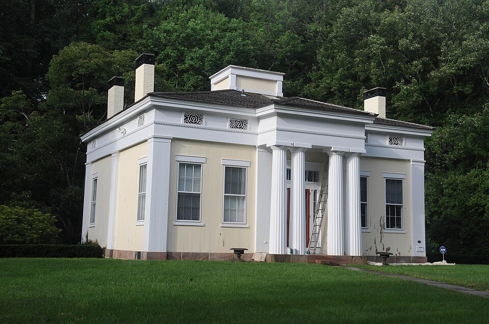
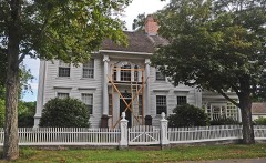
“The Charles Daniels House is a historic house at 43 Liberty Street in Chester, Connecticut. Built about 1830 for a local factory owner and moved to its present site in 1978, it is a prominent example of high-style Greek Revival architecture with a temple front, possibly designed by the firm of Ithiel Town.”
Wikipedia article Charles Daniels House, CC BY-SA 4.0.
One of 124 National Register listings published here for Middlesex County · listed in 1988 · category: Building.
National Register reference number.88000094- the number the National Park Service assigned this property when it was listed, and the key its nomination file is catalogued under at the National Archives.
THE town was originally known as Pattaconk Quarter of Saybrook, and subsequently as the Fourth Ecclesiastical Society of that town. It is bounded on the north by Haddam, east by Connecticut River, south by the South or Saw Mill Cove, and by the brook running into it as far west as the center of the Deep River bridge on the county road; thence due west to the Kil- Hngworth line; and west by Killingworth; being about five miles long, east and west, and more than three miles wide between north and south. It was incorporated as a town in 1836, and in 1856 a small portion of the south part was re-annexed to Saybrook. The portion of the town lying north of Chester Cove was called Pattaconk, Pataquonk, or Pattakonck. According to Dr. Trumbull's definition, it means a round or wigwam-shaped hill, a sweating place. The hill from which this section of the town took its name is now known as Fort Hill, near Warner's ferry, where it is supposed the Indians had a fort, and a sweating place to which they resorted in case of sickness. The process of sweating was performed by digging a hole in the ground and placing hot stones in it, then laying the patient over the hole, covered with skins or blankets, and after sweating a sufficient length of time, plunging in the river. There were two other sweating places between the north end of the county and the , mouth of the river; one in Chatham (old boundary), at a place called Indian Hill, and the other in Lyme, nearly opposite Saybrook Point, at a place known as Hothouse Swamp.
When the Indians sold the territory of Haddam to the white people, in 1662, it was claimed by both parties that it extended south to the Chester Cove or Pattaconk River, and the Indians reserved to themselves Thirty Mile Island, or Haddam Island, and forty acres in Pattaconk, Twenty Mile, or Lord's Island, having previously been sold to John Culiick. The forty acres reservation, it is supposed, extended from the south side of Pattaconk Hill to Parker's Point, bordering on the river. The Indians remained on these reservations many years; but a controversy arose between Saybrook and Haddam in regard to the boundary between the towns, and on the settlement of the matter by the General Court, in 1664, by giving Saybrook two miles north of the Pattaconk River, the Indian reservation was found to be in the limits of Saybrook. There has always been sorhe doubt in the minds of many in regard to the justice of this settlement of the boundary, but all parties had to abide by it, and the Indians, finding that their reservation of forty acres was in Saybrook, petitioned the authorities of that town to respect their rights in said reservation; but there is no evidence that they did so. In May 1705, Keepuquam and other Indians made application to the General Court for the quiet possession of the forty acres reservation, claiming it as an ancient right of their ancestors, and representing that they met with opposition to their claim from the inhabitants of Saybrook. The hearing of the matter by the General Court was deferred until the October session, and notice of the pending of the matter was served upon the selectmen of Saybrook, with orders to appear and answer to the complaint of the Indians. It is not known what disposition was finally made of the complaint.
Regional context, not property-specific
evidence. The
federal wildfire occurrence database
lists 181 fires within 5 miles of Charles Daniels House
between 1992 and 2020, burning about 210 acres in total. None started naturally. 2 were recorded as arson.
Distance is straight-line from the map coordinates, so a fire counted
here may appear on a neighbouring settlement's page as well.
Reported cause
Fires
Missing data/not specified/undetermined
94
Debris and open burning
33
Recreation and ceremony
24
Misuse of fire by a minor
11
Smoking
9
Railroad operations and maintenance
3
Equipment and vehicle use
2
Power generation/transmission/distribution
2
Arson/incendiarism
2
Other causes
1
The most recent of
them, most recent first, with the day each was reported and the service
that recorded it.
Regional context, not property-specific
evidence. The federal mineral resources record lists
13 workings within 5 miles of Charles Daniels House: 12 past producers, 1 producer.
1 still produces. What was taken out: Granite, Sand and Gravel, Construction, Stone, Dimension, Beryllium. Distance is straight-line from the
map coordinates, so a quarry counted here may appear on a neighbouring
settlement's page as well.
Regional context, not property-specific
evidence. The National Weather Service names
Chester, the town this property stands in, in 10 storm reports between 1996 and 2021: 5 thunderstorm wind, 2 hail, 1 tornado, 1 heavy rain.
No death or injury is recorded in these reports. Each account below is quoted exactly as the forecast office
filed it, from the NOAA Storm Events Database, and each date
opens the federal record of that event.
No historic map-sheet match is published
for this property yet. That does not mean no map exists. This record needs
a coordinate-quality review before it can be joined to a sheet boundary.
Browse the county's mapped places while that work is
pending.
Listed places nearby
6 within 8 miles
Other National Register properties close
enough to walk or drive between, ordered by distance from this one. Both
positions come from the same geocoding pass that matched these properties
to their map sheets.
Listing record. National Park Service National Register of Historic Places, listed-properties dataset, current to 2026-05-22.
Map join. Address geocoded through the United States Census geocoder, then tested against the published boundary of every sheet in the USGS Historical Topographic Map Collection.
How this page is made. Listing fields come from federal records; map-sheet coverage is a labelled coordinate-to-boundary calculation, not a source-field claim.
Wildfire. Short, Karen C. 2022. Spatial wildfire occurrence data for the United States, 1992-2020 [FPA_FOD_20221014]. 6th Edition. Fort Collins, CO: Forest Service Research Data Archive. https://doi.org/10.2737/RDS-2013-0009.6 Collected with United States Government funding and usable without additional permissions or fees.
Mines and quarries. USGS Mineral Resources Data System (MRDS) https://mrdata.usgs.gov/mrds/ A work of the United States government, no copyright under 17 U.S.C. 105.
Storms. NOAA National Centers for Environmental Information, Storm Events Database https://www.ncei.noaa.gov/stormevents/ A work of the United States government, no copyright under 17 U.S.C. 105. Narratives are quoted verbatim from the National Weather Service report and are not edited or summarised.
 Block